
Inter-American Highway
Encyclopedia

Central America
Central America is the central geographic region of the Americas. It is the southernmost, isthmian portion of the North American continent, which connects with South America on the southeast. When considered part of the unified continental model, it is considered a subcontinent...
n section of the Pan-American Highway
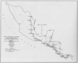
Pan-American Highway
The Pan-American Highway is a network of roads measuring about in total length. Except for an rainforest break, called the Darién Gap, the road links the mainland nations of the Americas in a connected highway system. According to Guinness World Records, the Pan-American Highway is the world's...
and spans 3,400 miles (5,470 km) between Nuevo Laredo
Nuevo Laredo
Nuevo Laredo is a city located in the Municipality of Nuevo Laredo in the Mexican state of Tamaulipas. The city lies on the banks of the Río Grande, across from the United States city of Laredo, Texas. The 2010 census population of the city was 373,725. Nuevo Laredo is part of the Laredo-Nuevo...
, Mexico
Mexico
The United Mexican States , commonly known as Mexico , is a federal constitutional republic in North America. It is bordered on the north by the United States; on the south and west by the Pacific Ocean; on the southeast by Guatemala, Belize, and the Caribbean Sea; and on the east by the Gulf of...
, and Panama City
Panama City
Panama is the capital and largest city of the Republic of Panama. It has a population of 880,691, with a total metro population of 1,272,672, and it is located at the Pacific entrance of the Panama Canal, in the province of the same name. The city is the political and administrative center of the...
, Panama
Panama
Panama , officially the Republic of Panama , is the southernmost country of Central America. Situated on the isthmus connecting North and South America, it is bordered by Costa Rica to the northwest, Colombia to the southeast, the Caribbean Sea to the north and the Pacific Ocean to the south. The...
.
The idea of a road being built across all of Central America became a tangible goal in 1923 as the United States
United States
The United States of America is a federal constitutional republic comprising fifty states and a federal district...
began conducting aerial surveys using the U.S. Army’s
United States Army
The United States Army is the main branch of the United States Armed Forces responsible for land-based military operations. It is the largest and oldest established branch of the U.S. military, and is one of seven U.S. uniformed services...
new photo reconnaissance and photographic aerial mapping technology. However, the aerial mapping effort was not directly tied to the upcoming Inter-American Highway project and was conducted with the cooperation of several of the Central American republics.
By 1940, the U.S. had a strong presence in Central America, especially in Panama. The U.S. owned and operated both the Panama Canal
Panama Canal
The Panama Canal is a ship canal in Panama that joins the Atlantic Ocean and the Pacific Ocean and is a key conduit for international maritime trade. Built from 1904 to 1914, the canal has seen annual traffic rise from about 1,000 ships early on to 14,702 vessels measuring a total of 309.6...
and the Panama Railroad, but with the looming war in Europe
Europe
Europe is, by convention, one of the world's seven continents. Comprising the westernmost peninsula of Eurasia, Europe is generally 'divided' from Asia to its east by the watershed divides of the Ural and Caucasus Mountains, the Ural River, the Caspian and Black Seas, and the waterways connecting...
, the U.S. felt it necessary to establish a more direct connection with Panama. Therefore, the U.S. and Panamanian governments agreed to begin the construction of a trans-isthmus highway located outside of the Canal Zone. Thus, the construction of the actual Inter-American Highway was instigated by the U.S. as a safety precaution at the beginning of World War II
World War II
World War II, or the Second World War , was a global conflict lasting from 1939 to 1945, involving most of the world's nations—including all of the great powers—eventually forming two opposing military alliances: the Allies and the Axis...
.
As with the Panama Canal project, the principal engineers and administrators of the highway construction were supplied by the United States. Working and living conditions varied depending on the location and season, but they were described by the North America
North America
North America is a continent wholly within the Northern Hemisphere and almost wholly within the Western Hemisphere. It is also considered a northern subcontinent of the Americas...
n crew as "primitive" and they recall their experiences as both "hilarious and tragic." For those stationed in larger cities, their families were allowed to come and stay with them as an incentive to keep them from returning to the U.S.
Many pieces of what is now the Inter-American Highway were constructed independently by individual countries prior to 1940. However, these roads only existed between large cities and were not in very good condition. Unlike in the United States, transportation in Central America had progressed rapidly from ox-cart paths to air transport creating numerous gaps in the ground transportation network. One of the greatest challenges faced by the workers was bridging these gaps.
Progress on the IAH was painstakingly slow due to the isolation of the building sites and frequent natural obstacles such as mountains and rivers. Nonetheless, construction on the IAH was hastened as the threat of the German
Germany
Germany , officially the Federal Republic of Germany , is a federal parliamentary republic in Europe. The country consists of 16 states while the capital and largest city is Berlin. Germany covers an area of 357,021 km2 and has a largely temperate seasonal climate...
U-boats in the Atlantic
Atlantic Ocean
The Atlantic Ocean is the second-largest of the world's oceanic divisions. With a total area of about , it covers approximately 20% of the Earth's surface and about 26% of its water surface area...
and Caribbean
Caribbean Sea
The Caribbean Sea is a sea of the Atlantic Ocean located in the tropics of the Western hemisphere. It is bounded by Mexico and Central America to the west and southwest, to the north by the Greater Antilles, and to the east by the Lesser Antilles....
increased. As part of the U.S. war effort, the U.S. Army Corps of Engineers began the construction of a "Military Road" in conjunction with the IAH. This group of engineers was allowed access to all the Central American nations involved in the original highway project due to the war emergency status of the Military Road.
The construction of both the IAH and the auxiliary military road progressed at a breakneck speed, and construction supplies quickly ran out. The scarcity of construction material only served to augment local unease concerning the project since local merchants had no precedence over imported materials from the U.S. or shipping rights, and therefore made little profit from the whole affair. Although construction did not directly benefit local business, it did provide employment of many of the local people. However, this positive impact only lasted as long as the construction team was in an area. For example, after the German submarine threat subsided (due to the presence of the U.S. Navy) the Army Corps ceased construction on the Military Road project, suddenly leaving many people unemployed and upset.
After the Army engineers left Central America, IAH construction started back up at full steam, having inherited a significant amount of supplies and equipment from the abandoned military project. By 1946, the IAH was ready for inspection by U.S. diplomats and engineers, but was far from being finished. Most of the road was only passable by Jeep
Jeep
Jeep is an automobile marque of Chrysler . The first Willys Jeeps were produced in 1941 with the first civilian models in 1945, making it the oldest off-road vehicle and sport utility vehicle brand. It inspired a number of other light utility vehicles, such as the Land Rover which is the second...
, but the basic road outline had been carved out of the surrounding jungle and mountains. The road was finally finished in 1967 and existed as a continuous strip of gravel, dirt, or asphalt between Panama and Mexico. The only section of the IAH that was constructed without any form of U.S. aid was the 1,600 mile strip between Nuevo Laredo and Malacatán
Malacatán
Malacatán is a municipality in the San Marcos department of Guatemala, located to the west of San Marcos town. It is fairly close to the border with Mexico - the border-crossing point is in the nearby village of El Carmen.-Sports:...
on the Mexico-Guatemala border.