
Klondike Highway
Encyclopedia

Alaska
Alaska is the largest state in the United States by area. It is situated in the northwest extremity of the North American continent, with Canada to the east, the Arctic Ocean to the north, and the Pacific Ocean to the west and south, with Russia further west across the Bering Strait...
n coastal town of Skagway
Skagway, Alaska
Skagway is a first-class borough in Alaska, on the Alaska Panhandle. It was formerly a city first incorporated in 1900 that was re-incorporated as a borough on June 25, 2007. As of the 2000 census, the population of the city was 862...
to Yukon
Yukon
Yukon is the westernmost and smallest of Canada's three federal territories. It was named after the Yukon River. The word Yukon means "Great River" in Gwich’in....
's Dawson City
Dawson City, Yukon
The Town of the City of Dawson or Dawson City is a town in the Yukon, Canada.The population was 1,327 at the 2006 census. The area draws some 60,000 visitors each year...
and its route somewhat parallels that used by prospectors in the 1898 Klondike Gold Rush
Klondike Gold Rush
The Klondike Gold Rush, also called the Yukon Gold Rush, the Alaska Gold Rush and the Last Great Gold Rush, was an attempt by an estimated 100,000 people to travel to the Klondike region the Yukon in north-western Canada between 1897 and 1899 in the hope of successfully prospecting for gold...
.
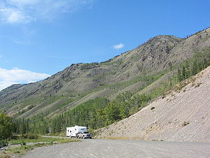
It winds in the state of Alaska for 24 kilometres (14.9 mi), up through the White Pass
White Pass
White Pass is a mountain pass through the Boundary Ranges of the Coast Mountains on the border of the U.S. state of Alaska and the province of British Columbia, Canada...
in the Coast Mountains
Coast Mountains
The Coast Mountains are a major mountain range, in the Pacific Coast Ranges, of western North America, extending from southwestern Yukon through the Alaska Panhandle and virtually all of the Coast of British Columbia. They are so-named because of their proximity to the sea coast, and are often...
where it crosses the Canadian border to British Columbia
British Columbia
British Columbia is the westernmost of Canada's provinces and is known for its natural beauty, as reflected in its Latin motto, Splendor sine occasu . Its name was chosen by Queen Victoria in 1858...
(BC) for 56 kilometres (34.8 mi), then enters Yukon
Yukon
Yukon is the westernmost and smallest of Canada's three federal territories. It was named after the Yukon River. The word Yukon means "Great River" in Gwich’in....
where it reaches the Alaska Highway
Alaska Highway
The Alaska Highway was constructed during World War II for the purpose of connecting the contiguous U.S. to Alaska through Canada. It begins at the junction with several Canadian highways in Dawson Creek, British Columbia and runs to Delta Junction, Alaska, via Whitehorse, Yukon...
near Whitehorse
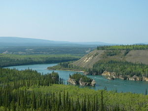
Whitehorse, Yukon
Whitehorse is Yukon's capital and largest city . It was incorporated in 1950 and is located at kilometre 1476 on the Alaska Highway in southern Yukon. Whitehorse's downtown and Riverdale areas occupy both shores of the Yukon River, which originates in British Columbia and meets the Bering Sea in...
and shares a short section with that highway until north of Whitehorse, where it diverges once more to Dawson City. The highway is 712 kilometres (442.4 mi) long.
In the Yukon, the Klondike Highway is marked as Yukon Highway 2. In Alaska, the Highway is marked as Alaska Route 98 (as in "route of 1898"). Until 1978, the unopened section between the BC border and Carcross had no official highway number, while the section north of Carcross to the Alaska Highway was Highway 5, and the section from Stewart Crossing to Dawson was Highway 3. The BC section is now maintained by the Yukon government as a natural extension of Highway 2.
South Klondike Highway
The original 53 km (32.9 mi) section known locally as the Carcross Road was actually made into a part of the Alaska Highway in 1942, until the Marsh LakeMarsh Lake
Marsh Lake is a widening of the Yukon River southeast of Whitehorse, Yukon, Canada. It is over 30 kilometres long and ranges from three to four kilometres wide.The co-ordinates of the lake are , and is 2,147 feet above sea level...
route was opened the next year. As Yukon Highway 5, it formed a loop road with Highway 6, the Tagish Road
Tagish Road
The Tagish Road is a 33-mile road, now hard surfaced, that links Jake's Corner on the Alaska Highway with Carcross, Yukon on the Klondike Highway. One mile from Jake's Corner is the terminus of the Atlin Road...
(now numbered as 8). It was renumbered as Highway 2 in 1978, being incorporated into the Klondike Highway designation. The road underwent alignment improvements during the 1980s. Residents living as far south as 25 kilometres (15.5 mi) from the Alaska Highway still give their residential addresses as historic mile measurements that start at zero at the Alaska Highway, even though the distances are no longer accurate, and kilometre posts count distance from Skagway's ferry terminal.
Construction of the "Carcross-Skagway Road" began in the 1950s, was abandoned partway up a mountain from Skagway, resumed in 1976-1977 and was completed between Skagway and Carcross
Carcross, Yukon
Carcross, originally known as Caribou Crossing, is an unincorporated community in the Territory of Yukon, Canada on Bennett Lake and Nares Lake. It has a population of 431 and is home to the Carcross/Tagish First Nation....
in August 1978. It was only open for a few weeks before seasonal closure. The first full summer season of use was in 1979.
The highway originally was built for tourist traffic, but in 1986 became important as a commercial transportation route, coincident with what seemed to be inevitable abandonment of the White Pass and Yukon Route
White Pass and Yukon Route
The White Pass and Yukon Route is a Canadian and U.S. Class II narrow gauge railroad linking the port of Skagway, Alaska, with Whitehorse, the capital of Yukon. An isolated system, it has no direct connection to any other railroad. Equipment, freight and passengers are ferried by ship through the...
railway. The new owners of the Faro
Faro, Yukon
Faro is a small town in the central Yukon, Canada, formerly the home of the largest open pit lead–zinc mine in the world as well as a significant producer of silver and other natural resource ventures. The mine was built by the Ralph M. Parsons Construction Company of the USA with General...
mine secured government agreement to open the highway for trucking. The last winter closure ended in the spring of 1986.
The Carcross-Skagway Road portion of the highway underwent substantial rerouting, widening and paving in the late 1980s and early 1990s. Although mining product does not currently traverse the highway, fuel tankers continue to travel the highway, which remains a popular tourist route (cars, RVs, buses), and provides an economic means for the White Pass railway to offer train excursions connecting at Fraser
Fraser, British Columbia
Fraser, British Columbia is a location on the Klondike Highway in northwestern British Columbia. It has no permanent residents or businesses. A Canada Border Services Agency port of entry is located here, along with a Yukon territorial government highway maintenance camp and a privately-owned...
to buses from or toward points north.
North Klondike Highway
The quality of roads from Whitehorse to Dawson City prior to 1950 was poor and only for the hardiest of travelers and motorized vehicles. The "Whitehorse-Mayo Road," Yukon's original Highway 2, extended along today's route from Whitehorse to Stewart Crossing, then turned northeast to MayoMayo, Yukon
Mayo is a village in the Yukon, Canada, along the Silver Trail and the Stewart River. The population was 248 in 2006. It is also the home of the First Nation of Nacho Nyak Dun, whose primary language is Northern Tutchone. Nacho Nyak Dun translates into "big river people". It is serviced by Mayo...
, Elsa
Elsa, Yukon
Elsa is a privately owned mining town based on silver, lead, and zinc in Yukon, Canada. It is located between the valley of the Stewart River to the south and the Mackenzie Mountains to the north. It is to the north of Whitehorse, and east of the Alaskan border...
and Keno City
Keno City, Yukon
Keno City is a small community in the Yukon at the end of the Silver Trail highway. Population was about 20 in 2001. Keno City was the site of a former silver-lead mining area proximal to Keno Hill. Keno City is 13 kilometres away from the Elsa, Yukon, which is owned by Alexco Resource Corp who...
. The last of three bridges was finished in 1960 to replace ferries at Carmacks, Pelly Crossing
Pelly Crossing, Yukon
Pelly Crossing is community in the Yukon, Canada. It lies where the Klondike Highway crosses the Pelly River. Population in 2008 was 291.It is the home of the Selkirk First Nation, and home to the Northern Tutchone culture. Cultural displays and artifacts are housed in a replica of Big Jonathan House...
and Stewart Crossing.
Yukon's original Highway 3, the Dawson-Mayo Road, was opened in September 1955 between Stewart Crossing and Dawson City. The Dawson-Mayo Road became part of Highway 2 in 1978 and was named the Klondike Highway, while the road northeast from Stewart Crossing became Highway 11, and was later named the Silver Trail
Silver Trail
The Silver Trail connects the communities of Mayo, Elsa and Keno City with the Klondike Highway at Stewart Crossing, where that highway crosses the Stewart River....
.
Even as of 1979, the entire Klondike Highway was gravel, but by 1982, some paving had been laid down as far north as Carmacks. Rebuilding and some rerouting was completed in the late 1980s.
The first 30 odd km of the North Klondike Highway are still often known as the Mayo Road to the residents of Whitehorse. Although kilometric distance markers have been in place since the early 1980s, residents in this area still identify their residential address as a mile measurement along the Mayo Road.
See also
- List of Yukon territorial highways
- List of Alaska Routes
- List of Canadian highways by province
- Overland Trail (Yukon)Overland Trail (Yukon)The Overland Trail was a Klondike Gold Rush-era transportation route between Whitehorse, Yukon and Dawson City in the Canadian Yukon Territory. It was built in 1902 at a cost of CDN$129,000 after the White Pass and Yukon Route railroad won a contract to deliver mail to the Dawson City gold fields...
Sources
- Internet travelog of Jim Teresco. Specifically Skagway, June 23, 2001, pictures 11 and 12 and their associated captions. Retrieved 2005-02-18.