

Watson Lake, Yukon
Encyclopedia
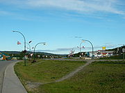
Town
A town is a human settlement larger than a village but smaller than a city. The size a settlement must be in order to be called a "town" varies considerably in different parts of the world, so that, for example, many American "small towns" seem to British people to be no more than villages, while...
at historical mile 635 on the Alaska Highway
Alaska Highway
The Alaska Highway was constructed during World War II for the purpose of connecting the contiguous U.S. to Alaska through Canada. It begins at the junction with several Canadian highways in Dawson Creek, British Columbia and runs to Delta Junction, Alaska, via Whitehorse, Yukon...
in the southeastern Yukon
Yukon
Yukon is the westernmost and smallest of Canada's three federal territories. It was named after the Yukon River. The word Yukon means "Great River" in Gwich’in....
close to the British Columbia
British Columbia
British Columbia is the westernmost of Canada's provinces and is known for its natural beauty, as reflected in its Latin motto, Splendor sine occasu . Its name was chosen by Queen Victoria in 1858...
border. Population in December 2004 was 1,547 (Yukon Bureau of Statistics).
Watson Lake is near the Liard River
Liard River
The Liard River flows through Yukon, British Columbia and the Northwest Territories, Canada. Rising in the Saint Cyr Range of the Pelly Mountains in southeastern Yukon, it flows southeast through British Columbia, marking the northern end of the Rocky Mountains and then curving northeast back...
, at the junction of the Robert Campbell Highway
Robert Campbell Highway
Yukon Highway 4, also known as the Robert Campbell Highway or Campbell Highway, is a road between Watson Lake, Yukon on the Alaska Highway to Carmacks, Yukon on the Klondike Highway. It is long and mostly gravel-surfaced...
and the Alaska Highway
Alaska Highway
The Alaska Highway was constructed during World War II for the purpose of connecting the contiguous U.S. to Alaska through Canada. It begins at the junction with several Canadian highways in Dawson Creek, British Columbia and runs to Delta Junction, Alaska, via Whitehorse, Yukon...
. The Cassiar Highway's northern end is 22 kilometres west of Watson Lake. The town is also served by the Watson Lake Airport
Watson Lake Airport
Watson Lake Airport is located west of Watson Lake, Yukon, Canada, and is operated by the Yukon government. The paved asphalt runway is long and is at an elevation of ....
; the airport was formerly served by Canadian Pacific Airlines and other local and regional airlines, but now only provides corporate and charter services.
Watson Lake is the main centre of the small forestry
Forestry
Forestry is the interdisciplinary profession embracing the science, art, and craft of creating, managing, using, and conserving forests and associated resources in a sustainable manner to meet desired goals, needs, and values for human benefit. Forestry is practiced in plantations and natural stands...
industry in the Yukon and has been a service centre for the mining
Mining
Mining is the extraction of valuable minerals or other geological materials from the earth, from an ore body, vein or seam. The term also includes the removal of soil. Materials recovered by mining include base metals, precious metals, iron, uranium, coal, diamonds, limestone, oil shale, rock...
industry, especially for the Cassiar
Cassiar, British Columbia
Cassiar is a ghost town in British Columbia, Canada. It was a small company-owned asbestos mining town located in the Cassiar Mountains of Northern British Columbia north of Dease Lake. After forty years of operation, starting in 1952, the mine was unexpectedly forced to close in 1992...
asbestos
Asbestos
Asbestos is a set of six naturally occurring silicate minerals used commercially for their desirable physical properties. They all have in common their eponymous, asbestiform habit: long, thin fibrous crystals...
mine in northern British Columbia
British Columbia
British Columbia is the westernmost of Canada's provinces and is known for its natural beauty, as reflected in its Latin motto, Splendor sine occasu . Its name was chosen by Queen Victoria in 1858...
and the Cantung
Cantung Mine
Cantung Mine is a tungsten producer in the Nahanni area of the Northwest Territories, Canada, located northeast of Watson Lake in the Flat River Valley of the Selwyn Range close to the Yukon border. Tungsten was originally discovered in the area in 1954 by prospectors. Cantung Mine operated from...
tungsten
Tungsten
Tungsten , also known as wolfram , is a chemical element with the chemical symbol W and atomic number 74.A hard, rare metal under standard conditions when uncombined, tungsten is found naturally on Earth only in chemical compounds. It was identified as a new element in 1781, and first isolated as...
mine on the Yukon-Northwest Territories
Northwest Territories
The Northwest Territories is a federal territory of Canada.Located in northern Canada, the territory borders Canada's two other territories, Yukon to the west and Nunavut to the east, and three provinces: British Columbia to the southwest, and Alberta and Saskatchewan to the south...
border in the Mackenzie Mountains
Mackenzie Mountains
The Mackenzie Mountains are a mountain range forming part of the Yukon-Northwest Territories boundary between the Liard and Peel rivers. The range is named in honour of Canada's second Prime Minister Alexander Mackenzie. Nahanni National Park Reserve is in the Mackenzie Mountains.The Mackenzie...
.
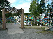
Tourist attractions in Watson Lake include the Northern Lights Centre and the much-imitated original Signpost Forest
Sign post forest
Sign Post Forest is a collection of signs at Watson Lake, Yukon and is one of the most famous of the landmarks along the Alaska Highway. It was started by a homesick GI in 1942. Visitors may add their own signs to the 75,000 already present.-Origin:...
. The Signpost Forest was started in 1942 by a homesick U.S. Army
United States Army Corps of Engineers
The United States Army Corps of Engineers is a federal agency and a major Army command made up of some 38,000 civilian and military personnel, making it the world's largest public engineering, design and construction management agency...
G.I. working on the Alaska Highway
Alaska Highway
The Alaska Highway was constructed during World War II for the purpose of connecting the contiguous U.S. to Alaska through Canada. It begins at the junction with several Canadian highways in Dawson Creek, British Columbia and runs to Delta Junction, Alaska, via Whitehorse, Yukon...
, who put up a sign with the name of his home town and the distance. Others followed suit and the tradition continues to this day. Today there are more than 76.000 (aug 2010) signs of various types depicting locations across the world. The Signpost Forest is one of four roadside attractions featured on the first series of the Canadian Roadside Attractions Series issued by Canada Post
Canada Post stamp releases (2005-2009)
In the latter half of the decade, Canada Post continued to issue a large number of stamps with different designs and themes. One of the key changes in the decade was that Canada Post issued series of stamps on a yearly basis. An example is the 400th Anniversary of the French Settlement in North...
on July 6, 2009.
Watson Lake and the neighbouring Upper Liard
Upper Liard, Yukon
Upper Liard is a chiefly First Nation settlement immediately west of Watson Lake in Canada's Yukon. It is situated at historical mile 642 of the Alaska Highway. Population in 2001 according to the Census was 159. Most of the residents are citizens of the Liard River First Nation, who also...
settlement are the home of the Liard River First Nation
Liard River First Nation
The Liard River First Nation, also known s the Liard First Nation is a First Nation in the southeastern Yukon Territory in Canada. Its main centres are Upper Liard, Yukon and Watson Lake, Yukon along the Alaska Highway...
, a member of the Kaska
Kaska
The Kaska or Kaska Dena are a First Nations people living mainly in northern British Columbia and the southeastern Yukon in Canada. The Kaska language originally spoken by the Kaska is an Athabaskan language....
Dena Council. The Two Mile area immediately north of the core of town is a concentrated area of First Nations residents, while the town extends five miles (8 km) out to the turn-off of Airport Road. (Originally, Airport Road extended directly to the Alaska Highway, but most of it is now part of the Campbell highway.)
Climate
Like most of the Yukon, Watson Lake has a subarctic climateSubarctic climate
The subarctic climate is a climate characterized by long, usually very cold winters, and short, cool to mild summers. It is found on large landmasses, away from the moderating effects of an ocean, generally at latitudes from 50° to 70°N poleward of the humid continental climates...
. Watson Lake experiences annual temperature average daily highs of 21°C (70°F) in July and average daily lows of -29°C (-20°F) in January. Record high temperature was 34°C (93°F) in May 1983 and the lowest was -59°C (-74°F) in January 1947. Watson Lake has more precipitation than other parts of the Yukon with an average annual snowfall of 197 cm (77.6 inches) and 255 mm (10 inches) of rainfall, resulting in larger trees and a more viable forest industry.