

Northern Cape
Encyclopedia
The Northern Cape is the largest and most sparsely populated province
of South Africa. It was created in 1994 when the Cape Province
was split up. Its capital is Kimberley. It includes the Kalahari Gemsbok National Park
, part of an international park shared with Botswana
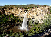
. It also includes the Augrabies Falls and the diamond mining regions in Kimberley and Alexander Bay
. The Namaqualand
region in the west is famous for its Namaqualand daisies. The southern towns of De Aar and Colesberg
, in the Great Karoo, are major transport nodes between Johannesburg
, Cape Town
and Port Elizabeth. In the northeast, Kuruman
is famous as a mission
station and also for its 'eye'. The Orange River
flows through the province, forming the borders with the Free State
in the southeast and with Namibia
to the northwest. The river is also used to irrigate the many vineyards in the arid region near Upington.
Native speakers of Afrikaans comprise a higher percentage of the population in the Northern Cape than in any other province. The Northern Cape's four official languages are Afrikaans, Tswana
, Xhosa
, and English
. Minorities speak the other official languages of South Africa, and a few people speak Khoisan languages
such as Nama and Khwe.
The provincial motto, Sa ||a !aĩsi 'uĩsi (“We go to a better life”), is in the Nǀu language of the Nǁnǂe (ǂKhomani) people. It was given in 1997 by one of the language's last speakers, Ms. Elsie Vaalbooi
of Rietfontein, who has since died. It was South Africa's first officially registered motto in a Khoisan language. Subsequently, South Africa's national motto, !Ke e /xarra //ke, was derived from the extinct Northern Cape ǀXam language.
in 1994, the others being Western Cape
to the south and Eastern Cape
to the southeast. Politically, it had been dominated since 1994 by the African National Congress
(ANC). Ethnic issues are important in the politics of the Northern Cape. For example, it is the site of the controversial Orania settlement, whose leaders have called for a Volkstaat
for the Afrikaner people in the province.
The Northern Cape is also the home of over 1,000 San
who immigrated from Namibia
following the independence of the country; they had served as trackers and scouts for the South African government during the war
, and feared reprisals from their former foes. They were awarded a settlement in Platfontein in 1999 by the Mandela government.
The precolonial history of the Northern Cape is reflected in a rich, mainly Stone Age, archaeological heritage
. Cave sites include Wonderwerk Cave
near Kuruman, which has a uniquely long sequence stretching from the turn of the twentieth century at the surface to more than 1 million (and possibly nearly 2 million) years in its basal layer (where stone tools, occurring in very low density, may be Oldowan). Many sites across the province, mostly in open air locales or in sediments alongside rivers or pans, document Earlier, Middle
and Later Stone Age habitation. From Later Stone Age times, mainly, there is a wealth of rock art
sites – most of which are in the form of rock engravings such as at Wildebeest Kuil
and many sites in the area known as ǀXam -ka !kau, in the Karoo. They occur on hilltops, slopes, rock outcrops and occasionally (as in the case of Driekops Eiland
near Kimberley), in a river bed. In the north eastern part of the province there are sites attributable to the Iron Age such as Dithakong
. Environmental factors have meant that the spread of Iron Age farming westwards (from the 17th century – but dating from the early first millennium AD in the eastern part of South Africa) was constrained mainly to the area east of the Langeberg Mountains, but with evidence of influence as far as the Upington area in the eighteenth century. From that period the archaeological record also reflects the development of a complex colonial frontier when precolonial social formations were considerably disrupted and there is an increasing 'fabric heavy' imprint of built structures, ash-heaps, and so on. The copper mines of Namaqualand and the diamond rush to the Kimberley area resulted in industrial archaeological landscapes in those areas which herald the modern era in South African history.
All archaeological traces in the Northern Cape that are greater than 100 years old are automatically protected by the South African Heritage Resources Act, while some are formally protected by declaration as either Provincial Heritage Sites (e.g. Wildebeest Kuil
and Nooitgedacht
) or National Heritage Sites (e.g. Wonderwerk Cave). The archaeology of the Richtersveld is part of the universal cultural value recognised in the area’s listing as a World Heritage Site
, while sites included on South Africa's Tentative List for World Heritage inscription include Wonderwerk Cave
and the ǀXam and ǂKhomani heartland.
 The Northern Cape is South Africa's largest province, and distances between towns are enormous due to its sparse population. Its size is just shy of the size of the American state of Montana
and slightly larger than that of Germany. The province is dominated by the Karoo
Basin and consists mostly of sedimentary rocks and some Dolerite intrusions. The south and south-east of the province is high-lying (1200m-1900m) in the Roggeveld and Nuweveld districts. The west coast is dominated by the Namaqualand
region, famous for its spring flowers. This area is hilly to mountainous and consists of Granites and other metamorphic rocks. The central areas are generally flat with interspersed salt pans. Kimberlite
intrusions punctuate the Karoo rocks, giving the province its most precious natural resource, Diamonds. The north is primarily Kalahari Desert, characterised by parallel red sand dunes and acacia tree dry savanna.
Northern Cape has a shoreline in the west on the South Atlantic Ocean. It borders the following areas of Namibia and Botswana:
Domestically, it borders the following provinces:
(or Gariep) River Basin, draining the interior of South Africa westwards into the Atlantic Ocean. (The political philosopher Neville Alexander
has used the idea of the ‘Garieb’ as a metaphor for nationhood in South Africa, a flowing together, in preference to the rainbow metaphor where the diverse colours remain distinct.)
The principal tributary of the Orange is the Vaal River
, which flows through part of the Northern Cape from the vicinity of Warrenton
. The Vaal, in turn, has tributaries within the province: the Harts River
and the Riet River
, which has its own major tributary, the Modder River
.
Above the Orange-Vaal confluence, the Seekoei River drains part of the northeastern Karoo into the Orange River above the Van der Kloof Dam.
Next downstream from the Orange-Vaal confluence is the Brak River, which flows non-perennially from the south and is in turn fed by the Ongers River, rising in the vicinities of Hanover
and Richmond
respectively.
Along the Orange River near the town of Kakamas, the Hartebeest River drains the central Karoo
. Above Kenhardt the Hartebeest is known as the Sak River, which has its source on the northern side of the escarpment, southeast of Williston
.
Further downstream from Kakamas, below the Augrabies Falls, and seldom actually flowing into the Orange River, is the Molopo River
, which comes down from the Kalahari in the north. With its tributary, the Nossob River
, it defines part of the international boundary between South Africa and Botswana
. Further tributaries of the Molopo River
include the Kuruman River, fed by the Moshaweng River and Kgokgole River, and the Matlhwaring River.
Flowing west into the Atlantic, in Namaqualand
, is the Buffels River and, further south, the Groen River.
, which often receives snow and temperatures occasionally drop below the -10 C mark.
, which are subdivided into 27 local municipalities
.
Population 10,000+
Population < 10,000
, the Northern Cape also has a substantial agricultural area around the Orange River
, including most of South Africa's sultana vineyards. Some Wine of Origin areas have been demarcated. The Orange River also attracts visitors who enjoy rafting tours around Vioolsdrif
. Extensive sheep raising is the basis of the economy in the southern Karoo
areas of the province.
and English
. Since 2001, the majority of the Northern Cape population has been Coloured
.
Some San people still follow their traditional hunter-gatherer
lifestyle in the Kalahari area of the Northern Cape. The area, especially along the Orange
and Vaal rivers, is rich in San rock engravings. A good collection can be seen at the McGregor Museum
in Kimberley. The province is also rich in fossils.
Provinces of South Africa
South Africa is currently divided into nine provinces. On the eve of the 1994 general election, South Africa's former homelands, also known as Bantustans, were reintegrated and the four existing provinces were divided into nine. The twelfth, thirteenth and sixteenth amendments to the constitution...
of South Africa. It was created in 1994 when the Cape Province
Cape Province
The Province of the Cape of Good Hope was a province in the Union of South Africa and subsequently the Republic of South Africa...
was split up. Its capital is Kimberley. It includes the Kalahari Gemsbok National Park
Kgalagadi Transfrontier Park
Kgalagadi Transfrontier Park is a large wildlife preserve and conservation area in southern Africa. The park straddles the border between South Africa and Botswana and comprises two adjoining national parks: Kalahari Gemsbok National Park in South Africa and Gemsbok National Park in Botswana. The...
, part of an international park shared with Botswana
Botswana
Botswana, officially the Republic of Botswana , is a landlocked country located in Southern Africa. The citizens are referred to as "Batswana" . Formerly the British protectorate of Bechuanaland, Botswana adopted its new name after becoming independent within the Commonwealth on 30 September 1966...
. It also includes the Augrabies Falls and the diamond mining regions in Kimberley and Alexander Bay
Alexander Bay, Northern Cape
Alexander Bay is a town in the extreme north-west of South Africa, also known as the region of Little Namaqualand. It is located on the southern bank of the Orange River mouth. It was named for Sir James Alexander, who was the first person to map the area whilst on a Royal Geographical Society...
. The Namaqualand
Namaqualand
Namaqualand is an arid region of Namibia and South Africa, extending along the west coast over and covering a total area of 170,000 square miles/440,000 km². It is divided by the lower course of the Orange River into two portions - Little Namaqualand to the south and Great Namaqualand to the...
region in the west is famous for its Namaqualand daisies. The southern towns of De Aar and Colesberg
Colesberg
Colesberg is a town with 17,354 inhabitants in the Northern Cape province of South Africa, located on the main road from Cape Town to Johannesburg....
, in the Great Karoo, are major transport nodes between Johannesburg
Johannesburg
Johannesburg also known as Jozi, Jo'burg or Egoli, is the largest city in South Africa, by population. Johannesburg is the provincial capital of Gauteng, the wealthiest province in South Africa, having the largest economy of any metropolitan region in Sub-Saharan Africa...
, Cape Town
Cape Town
Cape Town is the second-most populous city in South Africa, and the provincial capital and primate city of the Western Cape. As the seat of the National Parliament, it is also the legislative capital of the country. It forms part of the City of Cape Town metropolitan municipality...
and Port Elizabeth. In the northeast, Kuruman
Kuruman
Kuruman is a town with 12,701 inhabitants in Northern Cape province of South Africa, famous for its scenic beauty and the Eye of Kuruman, a geological feature bringing water from deep underground to the surface in the Kalahari Desert....
is famous as a mission
Mission (station)
A religious mission or mission station is a location for missionary work.While primarily a Christian term, the concept of the religious "mission" is also used prominently by the Church of Scientology and their Scientology Missions International....
station and also for its 'eye'. The Orange River
Orange River
The Orange River , Gariep River, Groote River or Senqu River is the longest river in South Africa. It rises in the Drakensberg mountains in Lesotho, flowing westwards through South Africa to the Atlantic Ocean...
flows through the province, forming the borders with the Free State
Free State
The Free State is a province of South Africa. Its capital is Bloemfontein, which is also South Africa's judicial capital. Its historical origins lie in the Orange Free State Boer republic and later Orange Free State Province. The current borders of the province date from 1994 when the Bantustans...
in the southeast and with Namibia
Namibia
Namibia, officially the Republic of Namibia , is a country in southern Africa whose western border is the Atlantic Ocean. It shares land borders with Angola and Zambia to the north, Botswana to the east and South Africa to the south and east. It gained independence from South Africa on 21 March...
to the northwest. The river is also used to irrigate the many vineyards in the arid region near Upington.
Native speakers of Afrikaans comprise a higher percentage of the population in the Northern Cape than in any other province. The Northern Cape's four official languages are Afrikaans, Tswana
Tswana language
Tswana or Setswana is a language spoken in Southern Africa by about 4.5 million people. It is a Bantu language belonging to the Niger–Congo language family within the Sotho languages branch of Zone S , and is closely related to the Northern- and Southern Sotho languages, as well as the Kgalagadi...
, Xhosa
Xhosa language
Xhosa is one of the official languages of South Africa. Xhosa is spoken by approximately 7.9 million people, or about 18% of the South African population. Like most Bantu languages, Xhosa is a tonal language, that is, the same sequence of consonants and vowels can have different meanings when said...
, and English
South African English
The term South African English is applied to the first-language dialects of English spoken by South Africans, with the L1 English variety spoken by Zimbabweans, Zambians and Namibians, being recognised as offshoots.There is some social and regional variation within South African English...
. Minorities speak the other official languages of South Africa, and a few people speak Khoisan languages
Khoisan languages
The Khoisan languages are the click languages of Africa which do not belong to other language families. They include languages indigenous to southern and eastern Africa, though some, such as the Khoi languages, appear to have moved to their current locations not long before the Bantu expansion...
such as Nama and Khwe.
The provincial motto, Sa ||a !aĩsi 'uĩsi (“We go to a better life”), is in the Nǀu language of the Nǁnǂe (ǂKhomani) people. It was given in 1997 by one of the language's last speakers, Ms. Elsie Vaalbooi
Elsie Vaalbooi
Elsie Vaalbooi of Rietfontein in the Northern Cape was a South African woman who was a member of the ǂKhomani San or Bushmen and one of the last speakers of the Nǁng language. In the 1990s there was concern amongst the ǂKhomani leadership about loss of the Nǁng language: many of those of the...
of Rietfontein, who has since died. It was South Africa's first officially registered motto in a Khoisan language. Subsequently, South Africa's national motto, !Ke e /xarra //ke, was derived from the extinct Northern Cape ǀXam language.
History
The Northern Cape was one of three provinces carved out of the Cape ProvinceCape Province
The Province of the Cape of Good Hope was a province in the Union of South Africa and subsequently the Republic of South Africa...
in 1994, the others being Western Cape
Western Cape
The Western Cape is a province in the south west of South Africa. The capital is Cape Town. Prior to 1994, the region that now forms the Western Cape was part of the much larger Cape Province...
to the south and Eastern Cape
Eastern Cape
The Eastern Cape is a province of South Africa. Its capital is Bhisho, but its two largest cities are Port Elizabeth and East London. It was formed in 1994 out of the "independent" Xhosa homelands of Transkei and Ciskei, together with the eastern portion of the Cape Province...
to the southeast. Politically, it had been dominated since 1994 by the African National Congress
African National Congress
The African National Congress is South Africa's governing Africanist political party, supported by its tripartite alliance with the Congress of South African Trade Unions and the South African Communist Party , since the establishment of non-racial democracy in April 1994. It defines itself as a...
(ANC). Ethnic issues are important in the politics of the Northern Cape. For example, it is the site of the controversial Orania settlement, whose leaders have called for a Volkstaat
Volkstaat
Volkstaat is a proposal for the establishment of self determination for the Boer and Afrikaners minority in South Africa according to federal principles, alluding to full independence in the form of a homeland for Boer and Afrikaners....
for the Afrikaner people in the province.
The Northern Cape is also the home of over 1,000 San
Bushmen
The indigenous people of Southern Africa, whose territory spans most areas of South Africa, Zimbabwe, Lesotho, Mozambique, Swaziland, Botswana, Namibia, and Angola, are variously referred to as Bushmen, San, Sho, Barwa, Kung, or Khwe...
who immigrated from Namibia
Namibia
Namibia, officially the Republic of Namibia , is a country in southern Africa whose western border is the Atlantic Ocean. It shares land borders with Angola and Zambia to the north, Botswana to the east and South Africa to the south and east. It gained independence from South Africa on 21 March...
following the independence of the country; they had served as trackers and scouts for the South African government during the war
Namibian War of Independence
See also South African Border War.The Namibian War of Independence, also known as the South African Border War, which lasted from 1966 to 1988, was a guerrilla war, which the nationalist South-West Africa People's Organization and others, fought against the apartheid government in South...
, and feared reprisals from their former foes. They were awarded a settlement in Platfontein in 1999 by the Mandela government.
The precolonial history of the Northern Cape is reflected in a rich, mainly Stone Age, archaeological heritage
Wiktionary
Wiktionary is a multilingual, web-based project to create a free content dictionary, available in 158 languages...
. Cave sites include Wonderwerk Cave
Wonderwerk Cave
Wonderwerk Cave is an archaeological site, formed originally as an ancient solution cavity in Dolomite rocks of the Kuruman Hills, situated between Danielskuil and Kuruman in the Northern Cape Province, South Africa. It is a National Heritage Site within a servitude ceded to and managed as a...
near Kuruman, which has a uniquely long sequence stretching from the turn of the twentieth century at the surface to more than 1 million (and possibly nearly 2 million) years in its basal layer (where stone tools, occurring in very low density, may be Oldowan). Many sites across the province, mostly in open air locales or in sediments alongside rivers or pans, document Earlier, Middle
Middle Stone Age
The Middle Stone Age was a period of African Prehistory between Early Stone Age and Late Stone Age. It is generally considered to have begun around 280,000 years ago and ended around 50-25,000 years ago. The beginnings of particular MSA stone tools have their origins as far back as 550-500,000...
and Later Stone Age habitation. From Later Stone Age times, mainly, there is a wealth of rock art
Rock art
Rock art is a term used in archaeology for any human-made markings made on natural stone. They can be divided into:*Petroglyphs - carvings into stone surfaces*Pictographs - rock and cave paintings...
sites – most of which are in the form of rock engravings such as at Wildebeest Kuil
Wildebeest Kuil Rock Art Centre
Wildebeest Kuil Rock Art Centre is a rock engraving site with visitor centre on land owned by the !Xun and Khwe San situated about 16 km from Kimberley, Northern Cape, South Africa. It is a declared Provincial Heritage Site managed by the Northern Cape Rock Art Trust in association with the...
and many sites in the area known as ǀXam -ka !kau, in the Karoo. They occur on hilltops, slopes, rock outcrops and occasionally (as in the case of Driekops Eiland
Driekops Eiland
Driekops Eiland is a rock engraving or petroglyph site in the bed of the Riet River close to the town of Plooysburg, near Kimberley, Northern Cape, South Africa.-The engravings:...
near Kimberley), in a river bed. In the north eastern part of the province there are sites attributable to the Iron Age such as Dithakong
Dithakong
Dithakong is the name of a place east of Kuruman in the Northern Cape, South Africa, which had been a major destination for several of the earliest nineteenth century expditions from the Cape to the interior of the subcontinent...
. Environmental factors have meant that the spread of Iron Age farming westwards (from the 17th century – but dating from the early first millennium AD in the eastern part of South Africa) was constrained mainly to the area east of the Langeberg Mountains, but with evidence of influence as far as the Upington area in the eighteenth century. From that period the archaeological record also reflects the development of a complex colonial frontier when precolonial social formations were considerably disrupted and there is an increasing 'fabric heavy' imprint of built structures, ash-heaps, and so on. The copper mines of Namaqualand and the diamond rush to the Kimberley area resulted in industrial archaeological landscapes in those areas which herald the modern era in South African history.
All archaeological traces in the Northern Cape that are greater than 100 years old are automatically protected by the South African Heritage Resources Act, while some are formally protected by declaration as either Provincial Heritage Sites (e.g. Wildebeest Kuil
Wildebeest Kuil Rock Art Centre
Wildebeest Kuil Rock Art Centre is a rock engraving site with visitor centre on land owned by the !Xun and Khwe San situated about 16 km from Kimberley, Northern Cape, South Africa. It is a declared Provincial Heritage Site managed by the Northern Cape Rock Art Trust in association with the...
and Nooitgedacht
Nooitgedacht Glacial Pavements
The Nooitgedacht Glacial Pavements comprise a geological feature between Kimberley and Barkly West, South Africa, pertaining to the Palaeozoic-age Dwyka Ice Age, or Karoo Ice Age, where the glacially scoured ancient bedrock was used, substantially more recently, during the Later Stone Age period...
) or National Heritage Sites (e.g. Wonderwerk Cave). The archaeology of the Richtersveld is part of the universal cultural value recognised in the area’s listing as a World Heritage Site
World Heritage Site
A UNESCO World Heritage Site is a place that is listed by the UNESCO as of special cultural or physical significance...
, while sites included on South Africa's Tentative List for World Heritage inscription include Wonderwerk Cave
Wonderwerk Cave
Wonderwerk Cave is an archaeological site, formed originally as an ancient solution cavity in Dolomite rocks of the Kuruman Hills, situated between Danielskuil and Kuruman in the Northern Cape Province, South Africa. It is a National Heritage Site within a servitude ceded to and managed as a...
and the ǀXam and ǂKhomani heartland.
Geography
Montana
Montana is a state in the Western United States. The western third of Montana contains numerous mountain ranges. Smaller, "island ranges" are found in the central third of the state, for a total of 77 named ranges of the Rocky Mountains. This geographical fact is reflected in the state's name,...
and slightly larger than that of Germany. The province is dominated by the Karoo
Karoo
The Karoo is a semi-desert region of South Africa. It has two main sub-regions - the Great Karoo in the north and the Little Karoo in the south. The 'High' Karoo is one of the distinct physiographic provinces of the larger South African Platform division.-Great Karoo:The Great Karoo has an area of...
Basin and consists mostly of sedimentary rocks and some Dolerite intrusions. The south and south-east of the province is high-lying (1200m-1900m) in the Roggeveld and Nuweveld districts. The west coast is dominated by the Namaqualand
Namaqualand
Namaqualand is an arid region of Namibia and South Africa, extending along the west coast over and covering a total area of 170,000 square miles/440,000 km². It is divided by the lower course of the Orange River into two portions - Little Namaqualand to the south and Great Namaqualand to the...
region, famous for its spring flowers. This area is hilly to mountainous and consists of Granites and other metamorphic rocks. The central areas are generally flat with interspersed salt pans. Kimberlite
Kimberlite
Kimberlite is a type of potassic volcanic rock best known for sometimes containing diamonds. It is named after the town of Kimberley in South Africa, where the discovery of an diamond in 1871 spawned a diamond rush, eventually creating the Big Hole....
intrusions punctuate the Karoo rocks, giving the province its most precious natural resource, Diamonds. The north is primarily Kalahari Desert, characterised by parallel red sand dunes and acacia tree dry savanna.
Northern Cape has a shoreline in the west on the South Atlantic Ocean. It borders the following areas of Namibia and Botswana:
- Karas Region, NamibiaKaras RegionThe Karas Region is the southernmost region of Namibia. The name assigned to the region reflects the prominence of the Karas mountain range in its southern part...
– northwest - Hardap Region, NamibiaHardap RegionHardap is one of the thirteen regions of Namibia. It is home to the Hardap Dam.Hardap stretches the entire width of Namibia, from the Atlantic Ocean in the west to Namibia's eastern national border. In the northeast, it borders the Kgalagadi District of Botswana, and in the southeast, it borders...
– far northwest - Kgalagadi District, BotswanaKgalagadiKgalagadi is a district in southwest Botswana, lying along the country's border with Namibia and South Africa. The administrative center is Tshabong. Kgalagadi covers a vast area of the Kalahari Desert. It has a total area of 105,200 km², and has a population of only 42,000...
– north
Domestically, it borders the following provinces:
- North WestNorth West (South African province)North West is a province of South Africa. Its capital is Mafikeng. The province is located to the west of the major population centre of Gauteng.-History:...
– northeast - Free StateFree StateThe Free State is a province of South Africa. Its capital is Bloemfontein, which is also South Africa's judicial capital. Its historical origins lie in the Orange Free State Boer republic and later Orange Free State Province. The current borders of the province date from 1994 when the Bantustans...
– east - Eastern CapeEastern CapeThe Eastern Cape is a province of South Africa. Its capital is Bhisho, but its two largest cities are Port Elizabeth and East London. It was formed in 1994 out of the "independent" Xhosa homelands of Transkei and Ciskei, together with the eastern portion of the Cape Province...
– southeast - Western CapeWestern CapeThe Western Cape is a province in the south west of South Africa. The capital is Cape Town. Prior to 1994, the region that now forms the Western Cape was part of the much larger Cape Province...
– south and southwest
Rivers
The major river system is the OrangeOrange River
The Orange River , Gariep River, Groote River or Senqu River is the longest river in South Africa. It rises in the Drakensberg mountains in Lesotho, flowing westwards through South Africa to the Atlantic Ocean...
(or Gariep) River Basin, draining the interior of South Africa westwards into the Atlantic Ocean. (The political philosopher Neville Alexander
Neville Alexander
Neville Edward Alexander is a proponent of a multilingual South Africa and a former revolutionary who spent ten years on Robben Island with Nelson Mandela.-Early life:...
has used the idea of the ‘Garieb’ as a metaphor for nationhood in South Africa, a flowing together, in preference to the rainbow metaphor where the diverse colours remain distinct.)
The principal tributary of the Orange is the Vaal River
Vaal River
The Vaal River is the largest tributary of the Orange River in South Africa. The river has its source in the Drakensberg mountains in Mpumalanga, east of Johannesburg and about 30 km north of Ermelo and only about 240 km from the Indian Ocean. It then flows westwards to its conjunction...
, which flows through part of the Northern Cape from the vicinity of Warrenton
Warrenton, Northern Cape
Warrenton is an agricultural town with a population of 25,100 situated in the Vaalharts Irrigation Scheme on the banks of the Vaal River in the Northern Cape Province of South Africa....
. The Vaal, in turn, has tributaries within the province: the Harts River
Harts River
The Harts River is a northern tributary of the Vaal River, which in turn is the largest tributary of the Orange River ....
and the Riet River
Riet River
The Riet River is a westward-flowing tributary of the Vaal River in central South Africa, of which a major tributary, in turn, is the Modder River. In precolonial times the Riet was known as the Gama-!ab , a !Kora name meaning muddy...
, which has its own major tributary, the Modder River
Modder River
The Modder River is a river in South Africa that forms part of the border between the Northern Cape and the Free State provinces.Modder River may also refer to:* Modder River, Northern Cape - A small town in the Northern Cape....
.
Above the Orange-Vaal confluence, the Seekoei River drains part of the northeastern Karoo into the Orange River above the Van der Kloof Dam.
Next downstream from the Orange-Vaal confluence is the Brak River, which flows non-perennially from the south and is in turn fed by the Ongers River, rising in the vicinities of Hanover
Hanover, Northern Cape
Hanover, a small town in the Northern Cape Province of South Africa, is named after Hanover in Germany. The town was established in 1854.Much of the farming in the area is with Merino sheep.- Tourist attractions :...
and Richmond
Richmond, Northern Cape
Richmond is a town in the central Karoo region of the Northern Cape Province, South Africa. It is situated on the main N1 route.-Origin, architecture and history:The town was established in 1843 in one of the coldest parts of South Africa's inland plateau...
respectively.
Along the Orange River near the town of Kakamas, the Hartebeest River drains the central Karoo
Karoo
The Karoo is a semi-desert region of South Africa. It has two main sub-regions - the Great Karoo in the north and the Little Karoo in the south. The 'High' Karoo is one of the distinct physiographic provinces of the larger South African Platform division.-Great Karoo:The Great Karoo has an area of...
. Above Kenhardt the Hartebeest is known as the Sak River, which has its source on the northern side of the escarpment, southeast of Williston
Williston, Northern Cape
Williston is a town in Northern Cape, South Africa. Originally settled by people from Germany, the town was renamed in honor of Hampden Willis in 1883.-References:...
.
Further downstream from Kakamas, below the Augrabies Falls, and seldom actually flowing into the Orange River, is the Molopo River
Molopo River
The Molopo River is located in southern Africa. The river generally flows to the southwest from its source, and has a length of approximately 960 kilometres. River flow is intermittent. When in flood, the flow discharges into the Orange River, which it meets downstream of Augrabies Falls National...
, which comes down from the Kalahari in the north. With its tributary, the Nossob River
Nossob River
The Nossob River is a dry river bed in eastern Namibia and the Kalahari region of South Africa and Botswana. It covers a distance of 740km and last flooded in 1989...
, it defines part of the international boundary between South Africa and Botswana
Botswana
Botswana, officially the Republic of Botswana , is a landlocked country located in Southern Africa. The citizens are referred to as "Batswana" . Formerly the British protectorate of Bechuanaland, Botswana adopted its new name after becoming independent within the Commonwealth on 30 September 1966...
. Further tributaries of the Molopo River
Molopo River
The Molopo River is located in southern Africa. The river generally flows to the southwest from its source, and has a length of approximately 960 kilometres. River flow is intermittent. When in flood, the flow discharges into the Orange River, which it meets downstream of Augrabies Falls National...
include the Kuruman River, fed by the Moshaweng River and Kgokgole River, and the Matlhwaring River.
Flowing west into the Atlantic, in Namaqualand
Namaqualand
Namaqualand is an arid region of Namibia and South Africa, extending along the west coast over and covering a total area of 170,000 square miles/440,000 km². It is divided by the lower course of the Orange River into two portions - Little Namaqualand to the south and Great Namaqualand to the...
, is the Buffels River and, further south, the Groen River.
Mountains
- LangebergLangebergThe Langeberg Mountain Range is a mountain range situated in the Western Cape Province of South Africa. The range runs in a generally east-west direction and is approximately 170 km long. The Langeberg's most westerly point is located 35 km west of the town of Swellendam; the range ends some 30 km...
- Korannaberg
- Skurweberge
- Kuruman Hills and Asbestos MountainsAsbestos MountainsThe Asbestos Mountains is a range of hills in the Northern Cape province of South Africa, stretching SSW from Kuruman, where the range is known as the Kuruman Hills, to Prieska...
- Ghaap Plateau
- Jan Swart se Berge
- Kareeberge
- KamiesbergeKamiesbergeThe Kamiesberge , is a mountain range of jumbled granite inselbergs or bornhardts dotted over sandy plains and centered around Kamieskroon in Namaqualand in South Africa. In appearance the range is very like the Matopos of Zimbabwe...
- RichtersveldRichtersveldThe Richtersveld is a mountainous desert landscape characterised by rugged kloofs and high mountains, situated in South Africa’s Northern Cape province. It is full of changing scenery from flat sandy plains, to craggy sharp mountains of volcanic rock and the lushness of the Orange River, which...
mountains - Hantamberge
Climate
Mostly arid to semi-arid, few areas in the province receive more than 400 mm (15.7 in) of rainfall per annum and the average annual rainfall over the province is 202 mm (8 in). Rainfall generally increases from west to east from a minimum average of 20 mm (0.78740157480315 in) to a maximum of 540 mm (21.3 in) per year. The west experiences most rainfall in winter, while the east receives most of its moisture from late summer thunderstorms. Many areas experience extreme heat, with the hottest temperatures in South Africa measured along the Namibian border. Summers maximums are generally 30 °C (86 °F) or higher, sometimes higher than 40 °C (104 °F). Winters are usually frosty and clear, with southern areas sometimes becoming bitterly cold, such as SutherlandSutherland, Northern Cape
- External links :* * *...
, which often receives snow and temperatures occasionally drop below the -10 C mark.
- KimberleyKimberley, Northern CapeKimberley is a city in South Africa, and the capital of the Northern Cape. It is located near the confluence of the Vaal and Orange Rivers. The town has considerable historical significance due its diamond mining past and siege during the Second Boer War...
averages: January maximum: 33 °C (min: 18 °C), June maximum: 18 °C (min: 3 °C), annual precipitation: 414 mm (16.3 in) - SpringbokSpringbok, Northern CapeSpringbok is the largest town in the Namaqualand area in the Northern Cape province of South Africa. it had a population of 10,294. Springbok is located on the N7 national road which connects the Cape with Namibia, and at the western end of the N14, which connects it with Upington and Pretoria...
averages: January maximum: 30 °C (min: 15 °C), July maximum: 17 °C (min: 7 °C), annual precipitation: 195 mm (7.7 in) - SutherlandSutherland, Northern Cape- External links :* * *...
averages: January maximum: 27 °C (min: 9 °C), July maximum: 13 °C (min: -3 °C), annual precipitation: 237 mm (9.3 in)
Municipalities
The Northern Cape Province is divided into five district municipalitiesDistrict municipality (South Africa)
In South Africa, a district municipality or Category C municipality is a municipality which executes some of the functions of local government for a district. The district municipality will in turn comprise several local municipalities, with which it shares the functions of local government...
, which are subdivided into 27 local municipalities
Local municipality (South Africa)
In South Africa, a local municipality or Category B municipality is a type of municipality that serves as the third, and most local, tier of local government...
.
|
|
Siyanda District Municipality Siyanda is one of the 5 districts of the Northern Cape province of South Africa. The seat of Siyanda is Upington. The majority of its 209 883 people speak Afrikaans...
|
Frances Baard District Municipality Frances Baard is one of the 5 districts of Northern Cape province of South Africa. The seat of Frances Baard is Kimberley. The majority of its 324 814 people speak Afrikaans . The district code is DC9....
|
|
Cities and towns
Population 50,000+- KimberleyKimberley, Northern CapeKimberley is a city in South Africa, and the capital of the Northern Cape. It is located near the confluence of the Vaal and Orange Rivers. The town has considerable historical significance due its diamond mining past and siege during the Second Boer War...
- UpingtonUpington, Northern CapeUpington is a town founded in 1884 and located in the Northern Cape province of South Africa, on the banks of the Orange River. The town was named after Sir Thomas Upington, Attorney-General and then Prime Minister of the Cape. It originated as a mission station established in 1875 and run by...
Population 10,000+
- Barkly West
- ColesbergColesbergColesberg is a town with 17,354 inhabitants in the Northern Cape province of South Africa, located on the main road from Cape Town to Johannesburg....
- De Aar
- Jan KempdorpJan KempdorpJan Kempdorp is an agricultural town situated in the centre of the Vaalharts Irrigation Scheme in the Northern Cape province of South Africa.Originally, the border between the Cape and Transvaal provinces ran through the town, making it the only town in South Africa that was in two provinces.During...
- KathuKathuKathu is a town in South Africa, and the iron ore capital of the Northern Cape province. Its name means "town under the trees", after the Camel Thorn forest it is situated in. The phrase "the town under the trees" was coined by an engineer working in the town in the early 1990 as part of a...
- KurumanKurumanKuruman is a town with 12,701 inhabitants in Northern Cape province of South Africa, famous for its scenic beauty and the Eye of Kuruman, a geological feature bringing water from deep underground to the surface in the Kalahari Desert....
- Postmasburg
- Prieska
- SpringbokSpringbok, Northern CapeSpringbok is the largest town in the Namaqualand area in the Northern Cape province of South Africa. it had a population of 10,294. Springbok is located on the N7 national road which connects the Cape with Namibia, and at the western end of the N14, which connects it with Upington and Pretoria...
- Victoria WestVictoria WestVictoria West is a town in the central Karoo region of South Africa's Northern Cape province. It is situated on the main N12 route, at an elevation of . It is the seat of the Ubuntu Local Municipality within the Pixley ka Seme DM....
- WarrentonWarrenton, Northern CapeWarrenton is an agricultural town with a population of 25,100 situated in the Vaalharts Irrigation Scheme on the banks of the Vaal River in the Northern Cape Province of South Africa....
Population < 10,000
- Carnarvon
- GariesGariesGaries is a small agricultural centre situated in South Africa's Northern Cape province about 110 km south of Springbok, the chief town of the Namaqualand district. Current population approximately 1500....
- Griekwastad
- Groblershoop
- HartswaterHartswaterHartswater is an agricultural town serving the northern section of the Vaalharts Irrigation Scheme in the Northern Cape province of South Africa. The town was laid out in 1948...
- KeimoesKeimoesKeimoes is a town in the Northern Cape province of South Africa. It lies on the Orange River and is about halfway between Upington and Kakamas....
- Pofadder
- Port NollothPort NollothPort Nolloth is a town and domestic seaport in the Namaqualand region on the northwestern coast of South Africa, 89 miles northwest of Springbok....
- StrydenburgStrydenburgStrydenburg is a town in the east of the Northern Cape province in South Africa. Seventy-seven km north of Britstown, it was laid out by the Dutch Reformed Church on the farm Roodepan in 1892. It also lies on the N12, which separates the actual town from its township.- External links :*...
- SutherlandSutherland, Northern Cape- External links :* * *...
- VanderkloofVanderkloofVanderkloof is a town in the Northern Cape province of South Africa. It's located on the Orange River and near the Rolfontein Nature Reserve....
Economy
Most famous for the diamond mines around KimberleyKimberley, Northern Cape
Kimberley is a city in South Africa, and the capital of the Northern Cape. It is located near the confluence of the Vaal and Orange Rivers. The town has considerable historical significance due its diamond mining past and siege during the Second Boer War...
, the Northern Cape also has a substantial agricultural area around the Orange River
Orange River
The Orange River , Gariep River, Groote River or Senqu River is the longest river in South Africa. It rises in the Drakensberg mountains in Lesotho, flowing westwards through South Africa to the Atlantic Ocean...
, including most of South Africa's sultana vineyards. Some Wine of Origin areas have been demarcated. The Orange River also attracts visitors who enjoy rafting tours around Vioolsdrif
Vioolsdrif
Vioolsdrif is a village on the Orange River in the north-western part of South Africa, known as Namaqualand.- Origin of name :The name in Afrikaans means 'the ford of the violin'. It is reportedly named after Jan Viool , who is said to have played the fiddle in these parts in the nineteenth century...
. Extensive sheep raising is the basis of the economy in the southern Karoo
Karoo
The Karoo is a semi-desert region of South Africa. It has two main sub-regions - the Great Karoo in the north and the Little Karoo in the south. The 'High' Karoo is one of the distinct physiographic provinces of the larger South African Platform division.-Great Karoo:The Great Karoo has an area of...
areas of the province.
Demographics
About 68% of the population speak Afrikaans, with other languages being Setswana, XhosaXhosa language
Xhosa is one of the official languages of South Africa. Xhosa is spoken by approximately 7.9 million people, or about 18% of the South African population. Like most Bantu languages, Xhosa is a tonal language, that is, the same sequence of consonants and vowels can have different meanings when said...
and English
South African English
The term South African English is applied to the first-language dialects of English spoken by South Africans, with the L1 English variety spoken by Zimbabweans, Zambians and Namibians, being recognised as offshoots.There is some social and regional variation within South African English...
. Since 2001, the majority of the Northern Cape population has been Coloured
Coloured
In the South African, Namibian, Zambian, Botswana and Zimbabwean context, the term Coloured refers to an heterogenous ethnic group who possess ancestry from Europe, various Khoisan and Bantu tribes of Southern Africa, West Africa, Indonesia, Madagascar, Malaya, India, Mozambique,...
.
Some San people still follow their traditional hunter-gatherer
Hunter-gatherer
A hunter-gatherer or forage society is one in which most or all food is obtained from wild plants and animals, in contrast to agricultural societies which rely mainly on domesticated species. Hunting and gathering was the ancestral subsistence mode of Homo, and all modern humans were...
lifestyle in the Kalahari area of the Northern Cape. The area, especially along the Orange
Orange River
The Orange River , Gariep River, Groote River or Senqu River is the longest river in South Africa. It rises in the Drakensberg mountains in Lesotho, flowing westwards through South Africa to the Atlantic Ocean...
and Vaal rivers, is rich in San rock engravings. A good collection can be seen at the McGregor Museum
McGregor Museum
The McGregor Museum in Kimberley, South Africa, originally known as the Alexander McGregor Memorial Museum, is a province-aided museum established in 1907.- Overview :...
in Kimberley. The province is also rich in fossils.
See also
- Griqualand WestGriqualand WestGriqualand West is an area of central South Africa with an area of 40,000 km² that now forms part of the Northern Cape Province. It was inhabited by the Griqua people - a semi-nomadic, Afrikaans-speaking nation of mixed-race origin, who established several states outside the expanding frontier...
- List of Speakers of the Northern Cape Provincial Legislature