
Karas Region
Encyclopedia
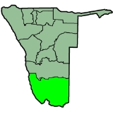
The Karas Region is the southernmost region
of Namibia
. The name assigned to the region reflects the prominence of the Karas mountain range
in its southern part. The Karas region is considered as a natural organic administrative and economic unit and includes the magisterial districts of Keetmanshoop
, Karasburg
, Bethanie and Lüderitz
.
Karas' western border is the shores of the Atlantic Ocean
. Its location in Namibia's south means that it shares a long border in the south and east with the Northern Cape
Province of South Africa. Domestically, it borders only the Hardap Region
, to the north.
Karas is subdivided into six electoral constituencies
:
with 65% of the votes. No other candidate received more than 10%.
and the Orange River have gained significantly in importance.
A further characteristic of the Region is the harbour town of Lüderitz and its fishing
and boat building industry, the diamond areas along the coast, both on and off shore, with Oranjemund
as the main centre, mining enterprises in the southern part of Namibia
(Klein Karas area, Rosh Pinah), the Kudu Gas field in the Atlantic Ocean
near Lüderitz
and small-scale industries in Lüderitz
and Keetmanshoop
.
The Hot Water Springs at Ai-Ais
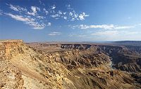
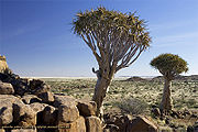
, and in future probably also the Hot Water Springs in Warmbad, the Kokerboom forest near Keetmanshoop, the Fish River Canyon
which is the second largest in the world, the Brukaros Mountain (a former volcano) near Berseba, the coastal town Lüderitz and several guest and game farms gave become important tourist attractions. The tourism industry has the potential for further expansion.
 The economic growth potential of the area is considerable but needs an intensive general development policy. It is a profitable tax-generating area, which predominantly comes from diamond
mining
for the central government.
The main railway line and two main trunk roads give access to South Africa
. Keetmanshoop is considered as the capital of the south and has direct air, railway and road links with Windhoek
. Its airport is of international standard and suitable for international air traffic. The airfield at Kolmanskop near Lüderitz is regularly visited by Air Namibia
on its flights to Cape Town
and Windhoek. Well developed landing facilities also exist at Oranjemund.
The region comprises six constituencies
: Keetmanshoop Urban
, Berseba
, Lüderitz, Oranjemund, Karasburg
, and Keetmanshoop Rural
.
Investment rewards for all
Potential for the tourism investor abounds in a country with so many as yet unexploited sites. Hospitality venues, resorts, tour operations and adventure excursions, game farming and hunting, local and ethnic craft manufacture are but a few of many opportunities open to the investor. These enterprises have the power to absorb local workers and improve labour skills – crucial where subsistence-type economic activity is still evident in rural areas and employment opportunities limited. Many incentives to businesses that actively integrate local peoples into tourism and related service industries are available from government.
The most commonly spoken languages at home were Afrikaans
(40% of households), Nama
/Damara (26%) and Oshiwambo (23%). For those 15 years and older, the literacy rate was 87%. In terms of education, 52% of girls and 48% of boys between the ages of 6-15 were attending school, and of those 15 years and older, 77% had left school, 7% were currently at school, and 7% had never attended.
The employment rate for the labor force (67% of those 15+) was 71% employed and 29% unemployed. For those 15 years old or older and not in the labor force (24%), 28% were students, 40% homemakers, and 32% retired or unable to work.
Among households, 94% had safe water, 26% no toilet facility, 50% electricity for lighting, 81% access to radio
, and 35% had wood or charcoal for cooking. In terms of households' main sources of income, 7% derived it from farming, 69% from wages and salaries, 6% cash remittances, 5% from business or non-farming, and 10% from pension.
For every 1,000 live births there were 37 female infant deaths and 56 male. The life expectancy at birth was 61 years for females and 54 for males. Among children younger than 15, 4% had lost a mother, 6% a father, and 1% were orphaned by both parents. Three percent of the entire population had a disability, of which 22% were deaf, 29% blind, 10% had a speech disability, 13% hand disability, 27% leg disability, and 7% mental disability.
Regions of Namibia
The administrative division of Namibia is tabled by Delimitation Commissions and accepted or declined by the National Assembly. The First Delimitation Commission chaired by Judge President Johan Strydom suggested in 1992 that Namibia be divided into 13 Regions, a number that has not been amended...
of Namibia
Namibia
Namibia, officially the Republic of Namibia , is a country in southern Africa whose western border is the Atlantic Ocean. It shares land borders with Angola and Zambia to the north, Botswana to the east and South Africa to the south and east. It gained independence from South Africa on 21 March...
. The name assigned to the region reflects the prominence of the Karas mountain range
Great Karas Mountains
The Great Karas Mountains are located in the Karas Region of southern Namibia. They are located in the driest part of the country. ǁKhauxaǃnas, an uninhabited village with a ruined fortress dating to the 18th century, is located to the east of the Mountains....
in its southern part. The Karas region is considered as a natural organic administrative and economic unit and includes the magisterial districts of Keetmanshoop
Keetmanshoop
Keetmanshoop is a city in Karas Region, southern Namibia, lying on the Trans-Namib Railway from Windhoek to Upington in South Africa. It is named after Johann Keetman, a German industrialist and founder of the city....
, Karasburg
Karasburg
Karasburg is city of 4,000 inhabitants in the Karas Region of southern Namibia and the district capital of the Karasburg electoral constituency. It lies at the heart of the southern Namibian sheep farming industry.- Location :...
, Bethanie and Lüderitz
Lüderitz
Lüderitz is a harbour town in south-west Namibia, lying on one of the least hospitable coasts in Africa. It is a port developed around Robert Harbour and Shark Island.- Overview :...
.
Karas' western border is the shores of the Atlantic Ocean
Atlantic Ocean
The Atlantic Ocean is the second-largest of the world's oceanic divisions. With a total area of about , it covers approximately 20% of the Earth's surface and about 26% of its water surface area...
. Its location in Namibia's south means that it shares a long border in the south and east with the Northern Cape
Northern Cape
The Northern Cape is the largest and most sparsely populated province of South Africa. It was created in 1994 when the Cape Province was split up. Its capital is Kimberley. It includes the Kalahari Gemsbok National Park, part of an international park shared with Botswana...
Province of South Africa. Domestically, it borders only the Hardap Region
Hardap Region
Hardap is one of the thirteen regions of Namibia. It is home to the Hardap Dam.Hardap stretches the entire width of Namibia, from the Atlantic Ocean in the west to Namibia's eastern national border. In the northeast, it borders the Kgalagadi District of Botswana, and in the southeast, it borders...
, to the north.
Karas is subdivided into six electoral constituencies
Constituencies of Namibia
Each of the 13 regions in Namibia are further subdivided into electoral constituencies. The number and size of each constituency varies with the size and population of each region. There are currently 107 constituencies in Namibia...
:
- BersebaBerseba ConstituencyBerseba is a constituency in the Karas Region of Namibia. Its population is 9,195, the main settlement is Berseba. The first diamonds in Namibia were found in this area in 1898, while oil was found in 1929...
- KarasburgKarasburg ConstituencyKarasburg is a constituency in the Karas Region of Namibia, with a population of 16,000. The main towns are Karasburg and Grünau; other populated places include Warmbad and Aussenkehr, and the border settlements of Ariamsvlei and Noordoewer...
- Keetmanshoop RuralKeetmanshoop RuralKeetmanshoop Rural is an electoral constituency in the Karas Region of Namibia. It contains the Krönlein suburb of Keetmanshoop and the villages of Koës and Aroab, the settlements of Seeheim and Klein Karas, as well as several farming communities in the area...
- Keetmanshoop UrbanKeetmanshoop UrbanKeetmanshoop Urban is a constituency in the Karas Region of Namibia. Its population is 14,945. It includes the city of Keetmanshoop....
- LüderitzLüderitz ConstituencyLüderitz is a constituency in the Karas Region of Namibia. In 2004, It had a population of 13,276. It contains the major city of Lüderitz, after which the constituency is named.-Politics:...
- OranjemundOranjemund ConstituencyOranjemund is a constituency in the Karas Region of Namibia. It covers an area of 27,000 sqkm and has a population of 18,200 inhabitants. The main towns are the district capital Oranjemund and the mining town of Rosh Pinah, the constituency also contains the Sendelingsdrift border post.Economic...
Politics
The Governor of Karas Region is Bernardus Swartbooi. In the 2004 presidential election, the region supported SWAPO's Hifikepunye PohambaHifikepunye Pohamba
Hifikepunye Lucas Pohamba is the second and current President of Namibia. He won the 2004 and 2009 presidential elections overwhelmingly as the candidate of the South West Africa People's Organisation ruling party, taking office in March 2005. He has also been the President of SWAPO since...
with 65% of the votes. No other candidate received more than 10%.
Economy
The region is a predominantly small stock farming area, consisting mostly of animals such as sheep or goats. Game farming and irrigation farming along the Naute DamNaute Dam
The Naute Dam is a dam outside of Keetmanshoop, Karas Region, Namibia. It was built between 1970-1972 and was officially commissioned in September 1972. It is the third largest dam in Namibia after Hardap Dam to Naute's north and holds up to 69 million cubic metres of water...
and the Orange River have gained significantly in importance.
A further characteristic of the Region is the harbour town of Lüderitz and its fishing
Fishing
Fishing is the activity of trying to catch wild fish. Fish are normally caught in the wild. Techniques for catching fish include hand gathering, spearing, netting, angling and trapping....
and boat building industry, the diamond areas along the coast, both on and off shore, with Oranjemund
Oranjemund
Oranjemund is a town of 4,000 inhabitants situated in the extreme southwest of Namibia, on the northern bank of the Orange River mouth. It exists to service the diamond industry....
as the main centre, mining enterprises in the southern part of Namibia
Namibia
Namibia, officially the Republic of Namibia , is a country in southern Africa whose western border is the Atlantic Ocean. It shares land borders with Angola and Zambia to the north, Botswana to the east and South Africa to the south and east. It gained independence from South Africa on 21 March...
(Klein Karas area, Rosh Pinah), the Kudu Gas field in the Atlantic Ocean
Atlantic Ocean
The Atlantic Ocean is the second-largest of the world's oceanic divisions. With a total area of about , it covers approximately 20% of the Earth's surface and about 26% of its water surface area...
near Lüderitz
Lüderitz
Lüderitz is a harbour town in south-west Namibia, lying on one of the least hospitable coasts in Africa. It is a port developed around Robert Harbour and Shark Island.- Overview :...
and small-scale industries in Lüderitz
Lüderitz
Lüderitz is a harbour town in south-west Namibia, lying on one of the least hospitable coasts in Africa. It is a port developed around Robert Harbour and Shark Island.- Overview :...
and Keetmanshoop
Keetmanshoop
Keetmanshoop is a city in Karas Region, southern Namibia, lying on the Trans-Namib Railway from Windhoek to Upington in South Africa. It is named after Johann Keetman, a German industrialist and founder of the city....
.
The Hot Water Springs at Ai-Ais
Ai-Ais Hot Springs
Ai-Ais Hot Springs meaning 'burning water' in the local Nama language, refers to the sulphurous thermal hot water springs found in the area. Pronounced "eye-ice", the natural hot-spring oasis is situated at the base of the mountain peaks at the southern end of Fish River Canyon, in the Karas Region...
, and in future probably also the Hot Water Springs in Warmbad, the Kokerboom forest near Keetmanshoop, the Fish River Canyon
Fish River Canyon
The Fish River Canyon is located in the south of Namibia. It is the second largest canyon in the world and the largest in Africa, as well as the second most visited tourist attraction in Namibia. It features a gigantic ravine, in total about long, up to 27 km wide and in places almost 550 metres...
which is the second largest in the world, the Brukaros Mountain (a former volcano) near Berseba, the coastal town Lüderitz and several guest and game farms gave become important tourist attractions. The tourism industry has the potential for further expansion.
Diamond
In mineralogy, diamond is an allotrope of carbon, where the carbon atoms are arranged in a variation of the face-centered cubic crystal structure called a diamond lattice. Diamond is less stable than graphite, but the conversion rate from diamond to graphite is negligible at ambient conditions...
mining
Mining
Mining is the extraction of valuable minerals or other geological materials from the earth, from an ore body, vein or seam. The term also includes the removal of soil. Materials recovered by mining include base metals, precious metals, iron, uranium, coal, diamonds, limestone, oil shale, rock...
for the central government.
The main railway line and two main trunk roads give access to South Africa
South Africa
The Republic of South Africa is a country in southern Africa. Located at the southern tip of Africa, it is divided into nine provinces, with of coastline on the Atlantic and Indian oceans...
. Keetmanshoop is considered as the capital of the south and has direct air, railway and road links with Windhoek
Windhoek
Windhoek is the capital and largest city of the Republic of Namibia. It is located in central Namibia in the Khomas Highland plateau area, at around above sea level. The 2001 census determined Windhoek's population was 233,529...
. Its airport is of international standard and suitable for international air traffic. The airfield at Kolmanskop near Lüderitz is regularly visited by Air Namibia
Air Namibia
Air Namibia is the national airline of Namibia, headquartered in Windhoek. It operates scheduled domestic, regional, and international passenger and cargo services under IATA airline designator SW and ICAO airline designator NMB. Its international hub is Windhoek Hosea Kutako International Airport,...
on its flights to Cape Town
Cape Town
Cape Town is the second-most populous city in South Africa, and the provincial capital and primate city of the Western Cape. As the seat of the National Parliament, it is also the legislative capital of the country. It forms part of the City of Cape Town metropolitan municipality...
and Windhoek. Well developed landing facilities also exist at Oranjemund.
The region comprises six constituencies
Constituencies of Namibia
Each of the 13 regions in Namibia are further subdivided into electoral constituencies. The number and size of each constituency varies with the size and population of each region. There are currently 107 constituencies in Namibia...
: Keetmanshoop Urban
Keetmanshoop Urban
Keetmanshoop Urban is a constituency in the Karas Region of Namibia. Its population is 14,945. It includes the city of Keetmanshoop....
, Berseba
Berseba Constituency
Berseba is a constituency in the Karas Region of Namibia. Its population is 9,195, the main settlement is Berseba. The first diamonds in Namibia were found in this area in 1898, while oil was found in 1929...
, Lüderitz, Oranjemund, Karasburg
Karasburg
Karasburg is city of 4,000 inhabitants in the Karas Region of southern Namibia and the district capital of the Karasburg electoral constituency. It lies at the heart of the southern Namibian sheep farming industry.- Location :...
, and Keetmanshoop Rural
Keetmanshoop Rural
Keetmanshoop Rural is an electoral constituency in the Karas Region of Namibia. It contains the Krönlein suburb of Keetmanshoop and the villages of Koës and Aroab, the settlements of Seeheim and Klein Karas, as well as several farming communities in the area...
.
Investment rewards for all
Potential for the tourism investor abounds in a country with so many as yet unexploited sites. Hospitality venues, resorts, tour operations and adventure excursions, game farming and hunting, local and ethnic craft manufacture are but a few of many opportunities open to the investor. These enterprises have the power to absorb local workers and improve labour skills – crucial where subsistence-type economic activity is still evident in rural areas and employment opportunities limited. Many incentives to businesses that actively integrate local peoples into tourism and related service industries are available from government.
Demographics
According to the Namibia 2001 Population and Housing Census, Hardap had a population of 69,329 (32,346 females and 36,976 males or 114 males for every 100 females) growing at an annual rate of 1.3%. The fertility rate was 3.1 children per woman. 54% lived in urban areas while 46% lived in rural areas, and with an area of 161,215km2, the population density was 0.4 persons per km2. By age, 11% of the population was under 5 years old, 20% between 5-14 years, 63% between 15-59 years, and 6% 60 years and older. The population was divided into 15,481 households, with an average size of 4.1 persons. 35% of households had a female head of house, while 65% had a male. For those 15 years and older, 69% had never married, 20% married with certificate, 2% married traditionally, 5% married consentually, 1% were divorced or separated, and 2% were widowed.The most commonly spoken languages at home were Afrikaans
Afrikaans
Afrikaans is a West Germanic language, spoken natively in South Africa and Namibia. It is a daughter language of Dutch, originating in its 17th century dialects, collectively referred to as Cape Dutch .Afrikaans is a daughter language of Dutch; see , , , , , .Afrikaans was historically called Cape...
(40% of households), Nama
Nama language
The Khoekhoe language, or Khoekhoegowab, also known by the ethnic term Nàmá and previously the now-discouraged term Hottentot, is the most widespread of the Khoisan languages. It belongs to the Khoe language family, and is spoken in Namibia, Botswana, and South Africa by three ethnic groups, the...
/Damara (26%) and Oshiwambo (23%). For those 15 years and older, the literacy rate was 87%. In terms of education, 52% of girls and 48% of boys between the ages of 6-15 were attending school, and of those 15 years and older, 77% had left school, 7% were currently at school, and 7% had never attended.
The employment rate for the labor force (67% of those 15+) was 71% employed and 29% unemployed. For those 15 years old or older and not in the labor force (24%), 28% were students, 40% homemakers, and 32% retired or unable to work.
Among households, 94% had safe water, 26% no toilet facility, 50% electricity for lighting, 81% access to radio
Radio
Radio is the transmission of signals through free space by modulation of electromagnetic waves with frequencies below those of visible light. Electromagnetic radiation travels by means of oscillating electromagnetic fields that pass through the air and the vacuum of space...
, and 35% had wood or charcoal for cooking. In terms of households' main sources of income, 7% derived it from farming, 69% from wages and salaries, 6% cash remittances, 5% from business or non-farming, and 10% from pension.
For every 1,000 live births there were 37 female infant deaths and 56 male. The life expectancy at birth was 61 years for females and 54 for males. Among children younger than 15, 4% had lost a mother, 6% a father, and 1% were orphaned by both parents. Three percent of the entire population had a disability, of which 22% were deaf, 29% blind, 10% had a speech disability, 13% hand disability, 27% leg disability, and 7% mental disability.