
Kgalagadi
Encyclopedia
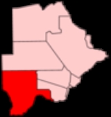
Kgalagadi is a district
in southwest Botswana
, lying along the country's border with Namibia
and South Africa
. The administrative center is Tshabong
. Kgalagadi covers a vast area of the Kalahari Desert
. It has a total area of 105,200 km², and has a population of only 42,000 (2001). More than one-third of the district is covered by the Kgalagadi Transfrontier Park
, which extends into South Africa.
Domestically, it borders the following districts of Botswana:
, which had a population of 6,591 in 2001 census while Hukuntsi
and Kang
had 3,807 and 3,744, respectively. The following is the list of villages noted separately in 2001 census in each census region.
Kgalagadi South:
Kgalagadi North:
Districts of Botswana
||Botswana is divided into 16 administrative districts: 10 rural districts and 6 urban districts. These are administered by 16 local authorities...
in southwest Botswana
Botswana
Botswana, officially the Republic of Botswana , is a landlocked country located in Southern Africa. The citizens are referred to as "Batswana" . Formerly the British protectorate of Bechuanaland, Botswana adopted its new name after becoming independent within the Commonwealth on 30 September 1966...
, lying along the country's border with Namibia
Namibia
Namibia, officially the Republic of Namibia , is a country in southern Africa whose western border is the Atlantic Ocean. It shares land borders with Angola and Zambia to the north, Botswana to the east and South Africa to the south and east. It gained independence from South Africa on 21 March...
and South Africa
South Africa
The Republic of South Africa is a country in southern Africa. Located at the southern tip of Africa, it is divided into nine provinces, with of coastline on the Atlantic and Indian oceans...
. The administrative center is Tshabong
Tshabong
Tshabong or Tsabong is the administrative centre of the Kgalagadi District, Botswana. It located in the Kalahari Desert. The population was 6,591 in 2001 census....
. Kgalagadi covers a vast area of the Kalahari Desert
Kalahari Desert
The Kalahari Desert is a large semi-arid sandy savannah in Southern Africa extending , covering much of Botswana and parts of Namibia and South Africa, as semi-desert, with huge tracts of excellent grazing after good rains. The Kalahari supports more animals and plants than a true desert...
. It has a total area of 105,200 km², and has a population of only 42,000 (2001). More than one-third of the district is covered by the Kgalagadi Transfrontier Park
Kgalagadi Transfrontier Park
Kgalagadi Transfrontier Park is a large wildlife preserve and conservation area in southern Africa. The park straddles the border between South Africa and Botswana and comprises two adjoining national parks: Kalahari Gemsbok National Park in South Africa and Gemsbok National Park in Botswana. The...
, which extends into South Africa.
Location
Kgalagadi's location causes it to border the following regions and provinces:- Omaheke Region, NamibiaOmahekeOmaheke is one of the thirteen regions of Namibia. Omaheke lies on the eastern border of Namibia and is the Western extension of the Kalahari desert. The name Omaheke is the Herero word for Sandveld. A large part of this region is known as the Sandveld...
- northwest - Hardap Region, NamibiaHardap RegionHardap is one of the thirteen regions of Namibia. It is home to the Hardap Dam.Hardap stretches the entire width of Namibia, from the Atlantic Ocean in the west to Namibia's eastern national border. In the northeast, it borders the Kgalagadi District of Botswana, and in the southeast, it borders...
- southwest - Northern Cape Province, South AfricaNorthern CapeThe Northern Cape is the largest and most sparsely populated province of South Africa. It was created in 1994 when the Cape Province was split up. Its capital is Kimberley. It includes the Kalahari Gemsbok National Park, part of an international park shared with Botswana...
- south - North West Province, South AfricaNorth West (South African province)North West is a province of South Africa. Its capital is Mafikeng. The province is located to the west of the major population centre of Gauteng.-History:...
- southeast
Domestically, it borders the following districts of Botswana:
- Ghanzi DistrictGhanzi DistrictGhanzi is a district in western Botswana, bordering Namibia in the west and extending east into much of the interior of the country. The district's administrative centre is the town of Ghanzi. Most of the eastern half of Ghanzi makes up the Central Kalahari Game Reserve...
- north - Kweneng DistrictKweneng DistrictKweneng is one of the districts of Botswana and is the recent historical homeland of the Bakwena people, the first group in Botswana converted to Christianity by famed missionary David Livingstone. Various landmarks, including Livingstone's Cave, allude to this history...
- northeast - Southern DistrictSouthern District (Botswana)Southern is one of the districts of Botswana. The capital of Southern district is Kanye, home to the Bangwaketse. It is one of the largest growing villages in Botswana. There are also other large villages in the southern district like Mushopa home to the Bakgatla-ba-ga Mmanaana, and Goodhope, home...
- east
Settlements
The largest settlement in the district is TshabongTshabong
Tshabong or Tsabong is the administrative centre of the Kgalagadi District, Botswana. It located in the Kalahari Desert. The population was 6,591 in 2001 census....
, which had a population of 6,591 in 2001 census while Hukuntsi
Hukuntsi
Hukuntsi is a village in Kgalagadi District in Botswana.Hukuntsi, meaning "four corners", is named for its status as one of the four major villages in its region of the Kgalagadi Desert. It's located 114 kilometres away from the village of Kang, off of the Gaborone-Ghanzi highway...
and Kang
Kang, Botswana
Kang is a village Kgalagadi District of Botswana. It is situated in the Kalahari Desert and lies on the Trans-Kalahari Highway between Ghanzi in the north and Sekoma in the south. Kang also provides access to the Kgalagadi Transfrontier Park in the south-west and the Central Kalahari Game Reserve...
had 3,807 and 3,744, respectively. The following is the list of villages noted separately in 2001 census in each census region.
Kgalagadi South:
- BogogoboBogogoboBogogobo is a village in Kgalagadi District of Botswana. It is located close to the border with South Africa and has a primary school. The population was 341 in 2001 census.-References:...
, BokspitsBokspitsBokspits is a village in Kgalagadi District of Botswana. It is the southernmost village in Botswana and is located close to the border with South Africa. Bokspits has a primary school and a clinic. The population was 499 in 2001 census.-References:...
, BrayBray, BotswanaBray is a village in Kgalagadi District of Botswana. It is located in the eastern part of the district, close to the border with South Africa and it has a primary school. The population was 899 in 2001 census.-References:...
, GachibanaGachibanaGachibana is a village in Kgalagadi District of Botswana. It is located close to the border with South Africa. Gachibana has a primary school, and the population was 501 in 2001 census.-References:...
, KhisaKhisaKhisa or Kisa is a village in Kgalagadi District of Botswana. It is located close to the border with South Africa, north-east of the district capital Tshabong. The population was 423 in 2001 census.-References:...
, KhuisKhuisKhuis is a village in Kgalagadi District of Botswana. It is located close to the border with South Africa. Khuis has a primary school, and the population was 755 in 2001 census.-References:...
, KhwawaKhwawaKhwawa is a village in Kgalagadi District of Botswana. It is located in the southern part of the district and has a primary school. The population was 517 in 2001 census.-References:...
, KokotshaKokotshaKokotsha is a village in Kgalagadi District of Botswana. It is located in the eastern part of the district, north of Werda. The population was 1,021 in 2001 census.-References:...
, KolonkwaneKolonkwaneKolonkwane is a village in Kgalagadi District of Botswana. It is located close to the border with South Africa and it has a primary school. The population was 591 in 2001 census.-References:...
, MakopongMakopongMakopong is a village in Kgalagadi District of Botswana. It is located close to the border with South Africa. The population was 1,501 in the 2001 census.-References:...
, MalesheMalesheMaleshe is a village in Kgalagadi District of Botswana. It is located close the capital of the district, Tshabong, and it has a primary school. The population was 389 in 2001 census....
, MaralalengMaralalengMaralaleng is a village in Kgalagadi District of Botswana. It is located east of the district capital Tshabong and has a primary school. The population was 487 in 2001 census.-References:...
, MaubeloMaubeloMaubelo is a village in Kgalagadi District of Botswana. It is located south of the district capital Tshabong and has a primary school. The population was 453 in 2001 census....
, MiddlepitsMiddlepitsMiddlepits is a village in Kgalagadi District of Botswana. It borders South Africa and has an immigration border post. There is a primary and junior secondary school. There is also health clinic which services a catchment area including five neighboring villages . Languages spoken include...
, OmawenenoOmawenenoOmaweneno is a village in Kgalagadi District of Botswana. It is located north-east of the district capital, Tshabong. The population was 1,068 in 2001 census.-References:...
, PhephengPhephengPhepheng, also known as Phepeng, Draaihoek or Draihoek, is a village in Kgalagadi District of Botswana. It is located north-east of the district capital Tshabong. The population was 1202 in 2007 census.-References:...
(Draaihoek), Rapples PanRapples PanRapples Pan is a village in Kgalagadi District of Botswana. It is located at the south-western tip of Botswana, close to South African border. It has a primary school, and the population was 278 in 2001 census.-References:...
, StruizendamStruizendamStruizendam is a village in Kgalagadi District of Botswana. It is located at the southern tip of Botswana, close to the border with South Africa, and it has a primary school. The population was 313 in 2001 census.-References:...
, TshabongTshabongTshabong or Tsabong is the administrative centre of the Kgalagadi District, Botswana. It located in the Kalahari Desert. The population was 6,591 in 2001 census....
, VaalhoekVaalhoekVaalhoek is a village in Kgalagadi District of Botswana. It is located at the southern tip of Botswana, close to the border with South Africa, and it has a primary school. The population was 346 in 2001 census.-References:...
, WerdaWerda, BotswanaWerda is a village in Kgalagadi District of Botswana. It is located close to the border with South Africa. The population was 1,961 in 2001 census.-References:...
Kgalagadi North:
- HukuntsiHukuntsiHukuntsi is a village in Kgalagadi District in Botswana.Hukuntsi, meaning "four corners", is named for its status as one of the four major villages in its region of the Kgalagadi Desert. It's located 114 kilometres away from the village of Kang, off of the Gaborone-Ghanzi highway...
, HunhukweHunhukweHunhukwe is a village in Kgalagadi District of Botswana. It is located in the northern part of the district, and it has a primary school and a clinic. The population was 431 in 2001 census.-References:...
, InalegoloInalegoloInalegolo is a village in Kgalagadi District of Botswana. It is located in the north-east part of the district, in Kalahari Desert, and it has a primary school. The population was 489 in 2001 census.-References:...
, KangKang, BotswanaKang is a village Kgalagadi District of Botswana. It is situated in the Kalahari Desert and lies on the Trans-Kalahari Highway between Ghanzi in the north and Sekoma in the south. Kang also provides access to the Kgalagadi Transfrontier Park in the south-west and the Central Kalahari Game Reserve...
, LehututuLehututuLehututu is a village in Kgalagadi District of Botswana. It is located in the Kalahari Desert, and it has primary and secondary schools. The population was 1,719 in 2001 census.-References:...
, LokgwabeLokgwabeLokgwabe is a village in Kgalagadi District of Botswana. It is located in the Kalahari Desert and the village has a primary school. The population was 1,304 in 2001 census....
, MakeMake, BotswanaMake is a village in Kgalagadi District of Botswana. It is located in the Kalahari Desert and it has a primary school. The population was 366 in 2001 census.-References:...
, MonongMonongMonong is a village in Kgalagadi District of Botswana. It is located in Kalahari Desert, and it has a primary school. The population was 172 in 2001 census.-References:...
, NcaangNcaangNcaang is a village in Kgalagadi District of Botswana. It is located in the northern part of the district, in Kalahari Desert. The population was 175 in 2001 census....
, NgwatleNgwatleNgwatle is a village in Kgalagadi District of Botswana. It is located in the Kalahari Desert, in the north-west part of the district. The population was 206 in 2001 census.-References:...
, PhuduhuduPhuduhudu, KgalagadiPhuduhudu is a village in Kgalagadi District of Botswana. It is located in the north-east part of the district, in Kalahari Desert, and it has a primary school. The population was 332 in 2001 census.-References:...
, TshaneTshaneTshane is a village in Kgalagadi District of Botswana. It is situated in Kalahari Desert, and is served by local Tshane Airport. The village has a primary school and the population was 858 in 2001 census.-References:...
, UkwiUkwiUkwi is a village in the Kalahari desert of Kgalagadi District, western Botswana, from the border with Namibia. The population was 453 in 2001 census....
, ZutswaZutswaZutswa is a village in Kgalagadi District of Botswana. It is located in the Kalahari Desert and it has a primary school. The population was 469 in 2001 census.-References:...