
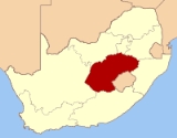
Free State
Encyclopedia
The Free State is a province
of South Africa
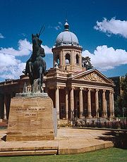
. Its capital is Bloemfontein
, which is also South Africa's judicial capital. Its historical origins lie in the Orange Free State
Boer republic and later Orange Free State Province
. The current borders of the province date from 1994 when the Bantustans were abolished and included into the provinces of South Africa. It is also the only one of the former provinces of South Africa not to undergo border changes, excluding the incorporation of Bantustans.
. The province is high-lying, with almost all land being 1,000 metres above sea level. The Drakensberg
and Maluti Mountains foothills raise the terrain to over 2,000 m in the east. The Free State lies in the heart of the Karoo
Sequence of rocks, containing shales
, mudstones, sandstones and the Drakensberg Basalt
forming the youngest capping rocks. Mineral deposits are plentiful, with gold and diamonds being of particular importance, mostly found in the north and west of the province.
and springbok
. The ridges, koppies and plains typical of the northern section are home to kudu
, red hartebeest
, white rhinoceros
and buffalo
. The African wildcat, black wildebeest, zebra
, eland
, white rhinoceros and wild dog
can be seen at the Soetdoring Nature Reserve
near Bloemfontein
.
, characterised by warm to hot summers and cool to cold winters. Areas in the east experience frequent snowfalls, especially on the higher ranges, whilst the west can be extremely hot in summer. Almost all precipitation
falls in the summer months as brief afternoon thunderstorms, with aridity increasing towards the west. Areas in the east around Harrismith
, Bethlehem
and Ficksburg
are well watered. The capital, Bloemfontein
, experiences hot, moist summers and cold, dry winters frequented by severe frost.
of Lesotho
:
Domestically, it borders the following provinces:
The Free State borders more districts of Lesotho and more provinces of South Africa than any other province.
It is traversed by the northwesterly line of equal latitude and longitude.
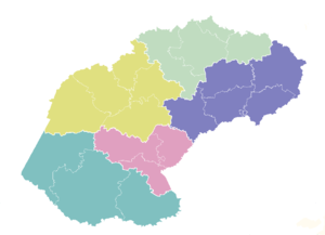 The Free State is divided into five district municipalities
(districts), subdivided into a total of 20 local municipalities :
 The Free State's major towns include:
It is also South Africa's leader in the production of biofuels, or fuel from agricultural crops, with a number of ethanol plants under construction in the grain-producing western region.
Field crops yield almost two-thirds of the gross agricultural income of the province. Animal products contribute a further 30%, with the balance generated by horticulture.
Ninety percent of the country's cherry crop is produced in the Ficksburg district, which is also home to the country's two largest asparagus canning factories. Soya, sorghum, sunflowers and wheat are cultivated in the eastern Free State, where farmers specialise in seed production. About 40% of the country's potato yield comes from the province's high-lying areas.
The main vegetable crop is asparagus, both white and green varieties. Although horticulture is expanding and becoming increasingly export-orientated, most produce leaves the province unprocessed.
The Free State's advantage in floriculture is the opposing seasons of the southern and northern hemispheres. The province exports about 1.2 million tons of cut flowers a year.
Gold mines in the Free State also supply a substantial portion of the total silver produced in the country, while considerable concentrations of uranium occurring in the gold-bearing conglomerates of the goldfields are extracted as a byproduct.
Bituminous coal is also mined, and converted to petrochemicals at Sasolburg. The Free State also produces high-quality diamonds from its kimberlite pipes and fissures, and the country's largest deposit of bentonite is found in the Koppies
district.
Some 14% of the province's manufacturing is classified as being in high-technology industries – the highest of all provincial economies. The northern Free State's chemicals sector is one of the most important in the southern hemisphere. Petrochemicals company Sasol
, based in the town of Sasolburg
, is a world leader in the production of fuels, waxes, chemicals and low-cost feedstock from coal.
is the province's prime tourist attraction. The park gets its name from the brilliant shades of gold cast by the sun on the spectacular sandstone cliffs, especially the imposing Brandwag or Sentinel Rock, which keeps vigil over the park.
 The sandstone of this region has been used for the lovely dressed-stone buildings found on the Eastern Highlands, while decoratively painted Sotho houses dot the grasslands. Some of South Africa's most valued San (Bushman) rock art is found in the Free State, particularly in the regions around Clarens
, Bethlehem
, Ficksburg
, Ladybrand
and Wepener
.
. Setswana is the main language in Tokologo
in the northwest, and in and around the area of Thaba Nchu
. It is the only province in the country with a Sesotho majority. Afrikaans
is widely spoken throughout the province, as a first language for the majority of whites and coloureds and as a second or third language by Sesotho, Setswana and isiZulu speakers. Although the numbers of first language English speakers are relatively low, it is becoming increasingly important as the language of business and government. This is further evidenced by the shift of tertiary institutions such as the University of the Free State
from Afrikaans to a dual English/Afrikaans medium of instruction.
(52.3%), Wepener
(60.2%) Ladybrand
(60.0%) and Kroonstad
(51.6%), and made up a substantial minority in Bloemfontein (45.7%) and Winburg
(36.3%).
Provinces of South Africa
South Africa is currently divided into nine provinces. On the eve of the 1994 general election, South Africa's former homelands, also known as Bantustans, were reintegrated and the four existing provinces were divided into nine. The twelfth, thirteenth and sixteenth amendments to the constitution...
of South Africa
South Africa
The Republic of South Africa is a country in southern Africa. Located at the southern tip of Africa, it is divided into nine provinces, with of coastline on the Atlantic and Indian oceans...
. Its capital is Bloemfontein
Bloemfontein
Bloemfontein is the capital city of the Free State Province of South Africa; and, as the judicial capital of the nation, one of South Africa's three national capitals – the other two being Cape Town, the legislative capital, and Pretoria, the administrative capital.Bloemfontein is popularly and...
, which is also South Africa's judicial capital. Its historical origins lie in the Orange Free State
Orange Free State
The Orange Free State was an independent Boer republic in southern Africa during the second half of the 19th century, and later a British colony and a province of the Union of South Africa. It is the historical precursor to the present-day Free State province...
Boer republic and later Orange Free State Province
Orange Free State Province
Orange Free State Province was one of the four provinces of South Africa from 1910-1994.Its predecessor was the Orange River Colony.In 1994 it was dissolved. Its borders were largely conterminous with those of the modern Free State Province...
. The current borders of the province date from 1994 when the Bantustans were abolished and included into the provinces of South Africa. It is also the only one of the former provinces of South Africa not to undergo border changes, excluding the incorporation of Bantustans.
Geography
The Free State is situated on flat boundless plains in the heart of South Africa. The rich soil and pleasant climate allow a thriving agricultural industry. With more than 30,000 farms, which produce over 70% of the country's grain, it is known locally as South Africa's breadbasketBreadbasket
The breadbasket or the granary of a country is a region which, because of richness of soil and/or advantageous climate, produces an agricultural surplus which is often considered vital for the country as a whole. Rice bowl is a similar term used in Southeast Asia...
. The province is high-lying, with almost all land being 1,000 metres above sea level. The Drakensberg
Drakensberg
The Drakensberg is the highest mountain range in Southern Africa, rising to in height. In Zulu, it is referred to as uKhahlamba , and in Sesotho as Maluti...
and Maluti Mountains foothills raise the terrain to over 2,000 m in the east. The Free State lies in the heart of the Karoo
Karoo
The Karoo is a semi-desert region of South Africa. It has two main sub-regions - the Great Karoo in the north and the Little Karoo in the south. The 'High' Karoo is one of the distinct physiographic provinces of the larger South African Platform division.-Great Karoo:The Great Karoo has an area of...
Sequence of rocks, containing shales
Shalës
Shalës is a municipality in the Elbasan District, Elbasan County, central Albania. The municipality consists of the villages Shalës, Licaj, Kurtalli, Xibrake, Xherie and Kodras....
, mudstones, sandstones and the Drakensberg Basalt
Basalt
Basalt is a common extrusive volcanic rock. It is usually grey to black and fine-grained due to rapid cooling of lava at the surface of a planet. It may be porphyritic containing larger crystals in a fine matrix, or vesicular, or frothy scoria. Unweathered basalt is black or grey...
forming the youngest capping rocks. Mineral deposits are plentiful, with gold and diamonds being of particular importance, mostly found in the north and west of the province.
Fauna and flora
The grassy plains in the south of the reserve provides ideal conditions for large herds of plain game such as black wildebeestBlack Wildebeest
The Black Wildebeest or White-tailed Gnu is one of two wildebeest species. The natural populations of this species, endemic to the southern part of Africa, have been almost completely exterminated, but the species has been reintroduced widely, both in private areas and nature reserves throughout...
and springbok
Springbok
Springbok can have the following meanings:* Springbok , a small antelope inhabiting southern and western Africa.* South Africa national rugby union team, known as the Springboks....
. The ridges, koppies and plains typical of the northern section are home to kudu
Kudu
The kudus are two species of antelope of the genus Tragelaphus:*Lesser Kudu, Tragelaphus imberbis*Greater Kudu, Tragelaphus strepsiceros- Etymology :...
, red hartebeest
Red Hartebeest
The Red Hartebeest is a species of even-toed ungulate in the Bovidae family. It is found in Southern Africa. There are more than 130,000 individuals left. The Red Hartebeest is closely related to the Tsessebe and the Topi....
, white rhinoceros
White Rhinoceros
The White Rhinoceros or Square-lipped rhinoceros is one of the five species of rhinoceros that still exist. It has a wide mouth used for grazing and is the most social of all rhino species...
and buffalo
African Buffalo
The African buffalo, affalo, nyati, Mbogo or Cape buffalo is a large African bovine. It is not closely related to the slightly larger wild Asian water buffalo, but its ancestry remains unclear...
. The African wildcat, black wildebeest, zebra
Zebra
Zebras are several species of African equids united by their distinctive black and white stripes. Their stripes come in different patterns unique to each individual. They are generally social animals that live in small harems to large herds...
, eland
Common Eland
The common eland , also known as the southern eland or eland antelope, is a savannah and plains antelope found in East and Southern Africa. It is the largest antelope in the African continent...
, white rhinoceros and wild dog
African Wild Dog
Lycaon pictus is a large canid found only in Africa, especially in savannas and lightly wooded areas. It is variously called the African wild dog, African hunting dog, Cape hunting dog, painted dog, painted wolf, painted hunting dog, spotted dog, or ornate wolf...
can be seen at the Soetdoring Nature Reserve
Soetdoring Nature Reserve
Soetdoring Nature Reserve is a nature reserve in Free State, South Africa. It covers approximately ....
near Bloemfontein
Bloemfontein
Bloemfontein is the capital city of the Free State Province of South Africa; and, as the judicial capital of the nation, one of South Africa's three national capitals – the other two being Cape Town, the legislative capital, and Pretoria, the administrative capital.Bloemfontein is popularly and...
.
Climate
The Free State experiences a continental climateContinental climate
Continental climate is a climate characterized by important annual variation in temperature due to the lack of significant bodies of water nearby...
, characterised by warm to hot summers and cool to cold winters. Areas in the east experience frequent snowfalls, especially on the higher ranges, whilst the west can be extremely hot in summer. Almost all precipitation
Precipitation (meteorology)
In meteorology, precipitation In meteorology, precipitation In meteorology, precipitation (also known as one of the classes of hydrometeors, which are atmospheric water phenomena is any product of the condensation of atmospheric water vapor that falls under gravity. The main forms of precipitation...
falls in the summer months as brief afternoon thunderstorms, with aridity increasing towards the west. Areas in the east around Harrismith
Harrismith
Harrismith, named after Sir Harry Smith, is a large town in the Free State province of South Africa, situated on the N3 highway approximately midway between Johannesburg, about 300 km north-east, and Durban. The town is at the junction with the N5 highway, which continues west towards the...
, Bethlehem
Bethlehem, Free State
Bethlehem is a town in the eastern Free State province of South Africa that is situated on the Liebenbergs river along a fertile valley just south of the Rooiberg Mountains on the N5 highway....
and Ficksburg
Ficksburg
Ficksburg is a town situated at the foot of the 450m high Imperani Mountain in Free State province, South Africa. The town was set up by General Johan Fick who won the territory in the Basotho Wars...
are well watered. The capital, Bloemfontein
Bloemfontein
Bloemfontein is the capital city of the Free State Province of South Africa; and, as the judicial capital of the nation, one of South Africa's three national capitals – the other two being Cape Town, the legislative capital, and Pretoria, the administrative capital.Bloemfontein is popularly and...
, experiences hot, moist summers and cold, dry winters frequented by severe frost.
- BloemfonteinBloemfonteinBloemfontein is the capital city of the Free State Province of South Africa; and, as the judicial capital of the nation, one of South Africa's three national capitals – the other two being Cape Town, the legislative capital, and Pretoria, the administrative capital.Bloemfontein is popularly and...
averages: January maximum: 31 °C (min: 15 °C), July maximum: 17 °C (min: -2 °C), annual precipitation: 559 mm - BethlehemBethlehem, Free StateBethlehem is a town in the eastern Free State province of South Africa that is situated on the Liebenbergs river along a fertile valley just south of the Rooiberg Mountains on the N5 highway....
averages: 27 °C (min: 13 °C), July maximum: 16 °C (min: -2 °C), annual precipitation: 680 mm
Borders
In the southeast, the Free State borders seven districtsDistricts of Lesotho
||The Kingdom of Lesotho is divided into ten districts, each headed by a district administrator. Each district has a capital known as a camptown. The districts are further subdivided into 80 constituencies, which consist of 129 local community councils. Most of the districts are named after their...
of Lesotho
Lesotho
Lesotho , officially the Kingdom of Lesotho, is a landlocked country and enclave, surrounded by the Republic of South Africa. It is just over in size with a population of approximately 2,067,000. Its capital and largest city is Maseru. Lesotho is a member of the Commonwealth of Nations. The name...
:
- MokhotlongMokhotlong DistrictMokhotlong district is a district of Lesotho. It includes the highest terrain in the Maloti Range and the source of the Senqu River, Lesotho’s primary watershed. It has an area of 4,075 km² and a population in 2006 of approximately 96,340. It is one of the poorest and most remote areas of...
– farthest to the east - Butha-ButheButha-Buthe DistrictButha-Buthe is a district of Lesotho. It has an area of 1,767 km² and a population in 2006 of approximately 109,529. Butha-Buthe is the capital or camptown, and only town in the district.-Geography:...
– northwest of Mokhotlong and northeast of Leribe - LeribeLeribe DistrictLeribè is a district of Lesotho. It has an area of 2,828 km² and a population in 2006 of approximately 298,352. Hlotse is the capital or camptown of the district. The district has one additional town, namely Maputsoe and Matukeng.-Geography:...
– southwest of Butha-Buthe and northeast of Berea - BereaBerea District-References:...
– southwest of Leribe and north of Maseru - MaseruMaseru DistrictMaseru is a district of Lesotho. It has an area of 4,279 km² and a population in 2006 of approximately 429,823. Maseru is also the name of the district's capital, and is the only city in the district. Additionally it is the capital of the country. It is the largest urban area in the country,...
– south of Berea and northeast of Mafeteng - MafetengMafeteng DistrictMafeteng is a district of Lesotho. It has an area of 2,119 km² and a population in 2006 of approximately 193,682. Mafeteng is the capital or camptown, and only town in the district.-Geography:...
– southwest of Maseru and northwest of Mohale's Hoek - Mohale's HoekMohale's Hoek DistrictMohale's Hoek is a district of Lesotho. It has an area of 3,530 km² and a population in 2006 of approximately 174,924. Mohale's Hoek is the capital city or camptown, and only town in the district.-Geography:...
– southeast of Mafeteng
Domestically, it borders the following provinces:
- KwaZulu-NatalKwaZulu-NatalKwaZulu-Natal is a province of South Africa. Prior to 1994, the territory now known as KwaZulu-Natal was made up of the province of Natal and the homeland of KwaZulu....
– east - Eastern CapeEastern CapeThe Eastern Cape is a province of South Africa. Its capital is Bhisho, but its two largest cities are Port Elizabeth and East London. It was formed in 1994 out of the "independent" Xhosa homelands of Transkei and Ciskei, together with the eastern portion of the Cape Province...
– south - Northern CapeNorthern CapeThe Northern Cape is the largest and most sparsely populated province of South Africa. It was created in 1994 when the Cape Province was split up. Its capital is Kimberley. It includes the Kalahari Gemsbok National Park, part of an international park shared with Botswana...
– west - North WestNorth West (South African province)North West is a province of South Africa. Its capital is Mafikeng. The province is located to the west of the major population centre of Gauteng.-History:...
– northwest - GautengGautengGauteng is one of the nine provinces of South Africa. It was formed from part of the old Transvaal Province after South Africa's first all-race elections on 27 April 1994...
– north - MpumalangaMpumalangaMpumalanga , is a province of South Africa. The name means east or literally "the place where the sun rises" in Swazi, Xhosa, Ndebele and Zulu. Mpumalanga lies in eastern South Africa, north of KwaZulu-Natal and bordering Swaziland and Mozambique. It constitutes 6.5% of South Africa's land area...
– northeast
The Free State borders more districts of Lesotho and more provinces of South Africa than any other province.
It is traversed by the northwesterly line of equal latitude and longitude.
Municipalities
Districts of South Africa
South Africa is divided into 52 districts . The 12th amendment to the Constitution reduced this number from 53. Another effect of this amendment is that each district is now completely contained within a province, thus eliminating cross-border districts. The districts also cover the entire area of...
(districts), subdivided into a total of 20 local municipalities :
|
Thabo Mofutsanyane District Municipality Thabo Mofutsanyana is one of the 5 districts of the Free State province of South Africa. The seat of Thabo Mofutsanyana is Witsieshoek. The majority of its 725 932 people speak Sesotho...
|
Motheo District Municipality Motheo was, until the municipal elections of 18 May 2011, a district of the Free State province of South Africa...
|
Xhariep District Municipality Xhariep is one of the 5 districts of Free State province of South Africa. The seat of Xhariep is Trompsburg. The largest language group in the 135 253 people is Afrikaans...
|
Lejweleputswa District Municipality Lejweleputswa is one of the 5 districts of Free State province of South Africa. The seat of Lejweleputswa is Welkom. The majority of its 657 019 people speak Sotho...
|
Major towns
- BloemfonteinBloemfonteinBloemfontein is the capital city of the Free State Province of South Africa; and, as the judicial capital of the nation, one of South Africa's three national capitals – the other two being Cape Town, the legislative capital, and Pretoria, the administrative capital.Bloemfontein is popularly and...
in Mangaung Metropolitan MunicipalityMangaung Metropolitan MunicipalityMangaung Metropolitan Municipality is a metropolitan municipality which governs Bloemfontein and surrounding towns in the Free State province of South Africa. Mangaung is a Sesotho name meaning "place of leopards"... - Bethlehem in Thabo MofutsanyaneThabo Mofutsanyane District MunicipalityThabo Mofutsanyana is one of the 5 districts of the Free State province of South Africa. The seat of Thabo Mofutsanyana is Witsieshoek. The majority of its 725 932 people speak Sesotho...
- SasolburgSasolburgSasolburg is a large industrial town in the far north of the Free State province of South Africa. Sasolburg is further sub-divided into three areas: Sasolburg proper, Vaalpark and Zamdela...
, ParysParysParys is a town situated on the banks of the Vaal River in the Free State province of South Africa. Population 43,791.In the eariy 1870's, towns in the northern Free State were situated very far apart and members of different churches had to travel great distances to participate in religious...
and KroonstadKroonstadKroonstad is the third-largest town in the Free State province of South Africa, and lies two hours drive from Gauteng. In the 1991 census it had a population of 110,963...
in Fezile DabiFezile Dabi District MunicipalityFezile Dabi District Municipality, formerly known as Northern Free State District Municipality, is one of the 5 districts of Free State province of South Africa. The seat of Northern Free State is Sasolburg. The majority of its 460 289 people speak Sesotho... - WelkomWelkomWelkom is a city in the Free State province of South Africa, located 160 kilometres northeast of Bloemfontein, the provincial capital. Welkom received municipal status in 1961 and was declared a city in 1968 on the 14th of February...
, OdendaalsrusOdendaalsrusOdendaalsrus is the oldest gold mining town in the Lejweleputswa District Municipality of the Free State province in South Africa.-History:It started out in 1912 as a ramshackle collection of farms and a central church that became a town. In April 1946 gold was struck on the farm Geduld near the town...
and VirginiaVirginia, Free StateVirginia is a gold mining town located in the Lejweleputswa District Municipality of the Free State province in South Africa about 140 km northeast of Bloemfontein the provincial capital...
in LejweleputswaLejweleputswa District MunicipalityLejweleputswa is one of the 5 districts of Free State province of South Africa. The seat of Lejweleputswa is Welkom. The majority of its 657 019 people speak Sotho...
Economy
The province is the granary of South Africa, with agriculture central to its economy, while mining on the rich goldfields reef is its largest employer.Agriculture
Agriculture dominates the Free State landscape, with cultivated land covering 32 000 square kilometres, and natural veld and grazing a further 87 000 square kilometres of the province.It is also South Africa's leader in the production of biofuels, or fuel from agricultural crops, with a number of ethanol plants under construction in the grain-producing western region.
Field crops yield almost two-thirds of the gross agricultural income of the province. Animal products contribute a further 30%, with the balance generated by horticulture.
Ninety percent of the country's cherry crop is produced in the Ficksburg district, which is also home to the country's two largest asparagus canning factories. Soya, sorghum, sunflowers and wheat are cultivated in the eastern Free State, where farmers specialise in seed production. About 40% of the country's potato yield comes from the province's high-lying areas.
The main vegetable crop is asparagus, both white and green varieties. Although horticulture is expanding and becoming increasingly export-orientated, most produce leaves the province unprocessed.
The Free State's advantage in floriculture is the opposing seasons of the southern and northern hemispheres. The province exports about 1.2 million tons of cut flowers a year.
Mining
The Free State is also rich in mineral wealth, gold representing 20% of the worlds total gold production. Mining is the province's major employer. The province has 12 gold mines, producing 30% of South Africa's output and making it the fifth-largest producer of gold in the world. The Harmony Gold Refinery and Rand Refinery are the only two gold refineries in South Africa.Gold mines in the Free State also supply a substantial portion of the total silver produced in the country, while considerable concentrations of uranium occurring in the gold-bearing conglomerates of the goldfields are extracted as a byproduct.
Bituminous coal is also mined, and converted to petrochemicals at Sasolburg. The Free State also produces high-quality diamonds from its kimberlite pipes and fissures, and the country's largest deposit of bentonite is found in the Koppies
Koppies
Koppies is a small town situated near the Renoster River in the Free State province of South Africa. It was originally called "Honing Kopjes" which is Dutch for "honey hills". This was due to there being Bee infestations in the nearby rocky hills, during the building of the railway line in 1904 by...
district.
Industry
Since 1989, the Free State economy has moved from dependence on primary sectors such as mining and agriculture to an economy increasingly oriented towards manufacturing and export.Some 14% of the province's manufacturing is classified as being in high-technology industries – the highest of all provincial economies. The northern Free State's chemicals sector is one of the most important in the southern hemisphere. Petrochemicals company Sasol
Sasol
Sasol Ltd. is a South African company involved in mining, energy, chemicals and synfuels. In particular, they produce petrol and diesel profitably from coal and natural gas using Fischer-Tropsch process...
, based in the town of Sasolburg
Sasolburg
Sasolburg is a large industrial town in the far north of the Free State province of South Africa. Sasolburg is further sub-divided into three areas: Sasolburg proper, Vaalpark and Zamdela...
, is a world leader in the production of fuels, waxes, chemicals and low-cost feedstock from coal.
Tourism
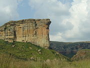
In the northeastern Free State, nestled in the rolling foothills of the Maluti mountains, the Golden Gate Highlands National ParkGolden Gate Highlands National Park
Golden Gate Highlands National Park is located in Free State, Republic of South Africa, near the Lesotho border. It covers an area of 340 km² . The park's most notable features are its golden, ochre, and orange-hued deeply eroded sandstone cliffs and outcrops, especially the Brandwag rock...
is the province's prime tourist attraction. The park gets its name from the brilliant shades of gold cast by the sun on the spectacular sandstone cliffs, especially the imposing Brandwag or Sentinel Rock, which keeps vigil over the park.
Clarens, Free State
Clarens is a small town situated in the foothills of the Maluti Mountains in the Free State province of South Africa and nicknamed the "Jewel of the Eastern Free State"...
, Bethlehem
Bethlehem, Free State
Bethlehem is a town in the eastern Free State province of South Africa that is situated on the Liebenbergs river along a fertile valley just south of the Rooiberg Mountains on the N5 highway....
, Ficksburg
Ficksburg
Ficksburg is a town situated at the foot of the 450m high Imperani Mountain in Free State province, South Africa. The town was set up by General Johan Fick who won the territory in the Basotho Wars...
, Ladybrand
Ladybrand
Ladybrand is a small agricultural town in the Free State province of South Africa, situated 18 km from Maseru, the capital of Lesotho. Ladybrand is one of five towns that forms the Mantsopa Local Municipality...
and Wepener
Wepener
Wepener is a village in the Free State, South Africa, located on the border with Lesotho. The town is named after Louw Wepener, the leader of the Boers in their war with the Basotho chief Moshoeshoe I in 1865. It was founded in 1867 on the banks of Jammersbergspruit, a tributary of the Caledon...
.
Demographics
Sesotho is the dominant home language in most of the province. isiZulu is the major language in the far eastern municipality of PhumelelaPhumelela Local Municipality
Phumelela Local Municipality is an administrative area in the Thabo Mofutsanyane District of the Free State in South Africa. The name "Phumelela" means "to succeed" in isiZulu....
. Setswana is the main language in Tokologo
Tokologo Local Municipality
Tokologo Local Municipality is an administrative area in the Lejweleputswa District of the Free State in South Africa. The name is a Setswana word meaning "freedom"....
in the northwest, and in and around the area of Thaba Nchu
Thaba Nchu
Thaba Nchu is a town in Free State, South Africa, located 60 km east of Bloemfontein. Its population is largely made up of Tswana and Sotho people. The town was settled in the 1830s and officially established in 1873...
. It is the only province in the country with a Sesotho majority. Afrikaans
Afrikaans
Afrikaans is a West Germanic language, spoken natively in South Africa and Namibia. It is a daughter language of Dutch, originating in its 17th century dialects, collectively referred to as Cape Dutch .Afrikaans is a daughter language of Dutch; see , , , , , .Afrikaans was historically called Cape...
is widely spoken throughout the province, as a first language for the majority of whites and coloureds and as a second or third language by Sesotho, Setswana and isiZulu speakers. Although the numbers of first language English speakers are relatively low, it is becoming increasingly important as the language of business and government. This is further evidenced by the shift of tertiary institutions such as the University of the Free State
University of the Free State
The University of the Free State is situated in Bloemfontein, the capital of the Free State, South Africa. The university also has a satellite campus in Qwaqwa that was, until 2003, part of the University of the North.-Academic Divisions:...
from Afrikaans to a dual English/Afrikaans medium of instruction.
Ethnicity
Despite now making up only 10% of the province's ethnic make-up, the white population of the Free State are an influential one. The vast majority of white people in the Free State are Afrikaans-speaking. In 1880 the white population made up 45.7% of the total population. In 1904 this had fallen to 36.8%. Of the 142,679 people in 1904, only 60% were born in the province. Of the 2726 European immigrants born in non-British states, 1025 came from Russian Poland. In 1904 whites made up a majority in most settlements, namely FicksburgFicksburg
Ficksburg is a town situated at the foot of the 450m high Imperani Mountain in Free State province, South Africa. The town was set up by General Johan Fick who won the territory in the Basotho Wars...
(52.3%), Wepener
Wepener
Wepener is a village in the Free State, South Africa, located on the border with Lesotho. The town is named after Louw Wepener, the leader of the Boers in their war with the Basotho chief Moshoeshoe I in 1865. It was founded in 1867 on the banks of Jammersbergspruit, a tributary of the Caledon...
(60.2%) Ladybrand
Ladybrand
Ladybrand is a small agricultural town in the Free State province of South Africa, situated 18 km from Maseru, the capital of Lesotho. Ladybrand is one of five towns that forms the Mantsopa Local Municipality...
(60.0%) and Kroonstad
Kroonstad
Kroonstad is the third-largest town in the Free State province of South Africa, and lies two hours drive from Gauteng. In the 1991 census it had a population of 110,963...
(51.6%), and made up a substantial minority in Bloemfontein (45.7%) and Winburg
Winburg
Winburg is a small mixed farming town in the Free State province of South Africa.It is the oldest proclaimed town in the Orange Free State, South Africa and thus along with Griquatown, one of the oldest settlements in South Africa located north of the Orange River.Winburg is situated midway...
(36.3%).
Education
- Universities
- University of the Free StateUniversity of the Free StateThe University of the Free State is situated in Bloemfontein, the capital of the Free State, South Africa. The university also has a satellite campus in Qwaqwa that was, until 2003, part of the University of the North.-Academic Divisions:...
(BloemfonteinBloemfonteinBloemfontein is the capital city of the Free State Province of South Africa; and, as the judicial capital of the nation, one of South Africa's three national capitals – the other two being Cape Town, the legislative capital, and Pretoria, the administrative capital.Bloemfontein is popularly and...
) - Central University of TechnologyCentral University of TechnologyCentral University of Technology, Free State or Central University of Technology is a University of Technology in Bloemfontein in the Free State province of South Africa. It was established in 1981 as "Technikon Free State". As part of the South African government's restructuring of tertiary...
(BloemfonteinBloemfonteinBloemfontein is the capital city of the Free State Province of South Africa; and, as the judicial capital of the nation, one of South Africa's three national capitals – the other two being Cape Town, the legislative capital, and Pretoria, the administrative capital.Bloemfontein is popularly and...
, WelkomWelkomWelkom is a city in the Free State province of South Africa, located 160 kilometres northeast of Bloemfontein, the provincial capital. Welkom received municipal status in 1961 and was declared a city in 1968 on the 14th of February...
)
- University of the Free State
- Other educational institutions
- Flavius Mareka FET CollegeFlavius Mareka FET CollegeFlavius Mareka FET College is situated in the Fezile Dabi District of the Free State Province, South Africa. The Flavius Mareka FET College includes the following former institutions: Kroonstad - Mphohadi - and Sasolburg Campus....
(KroonstadKroonstadKroonstad is the third-largest town in the Free State province of South Africa, and lies two hours drive from Gauteng. In the 1991 census it had a population of 110,963...
, Mphohardi, SasolburgSasolburgSasolburg is a large industrial town in the far north of the Free State province of South Africa. Sasolburg is further sub-divided into three areas: Sasolburg proper, Vaalpark and Zamdela...
)
- Flavius Mareka FET College
Provincial sport teams
- Soccer
- African Warriors (PhuthaditjhabaPhuthaditjhabaPhuthaditjhaba is a town in the Free State province of South Africa. The frequent snow on the Drakensberg mountain peaks surrounding the town led the San to call the region Qwa-Qwa . It was known as Witsiehoek to the European settlers. The area was then turned into the bantustan or homeland of...
) - Carara Kicks F.C.Carara Kicks F.C.Carara Kicks are a South African football club based in Welkom, Free State that participates in theNational First Division.The club is owned by Motebang Mokoena, the son of Free State Stars owner Mike Mokoena and serves as a feeder team to Stars who play in the Premier Soccer League.-External...
(WelkomWelkomWelkom is a city in the Free State province of South Africa, located 160 kilometres northeast of Bloemfontein, the provincial capital. Welkom received municipal status in 1961 and was declared a city in 1968 on the 14th of February...
) - Bloemfontein CelticBloemfontein CelticBloemfontein Celtic is a South African football club based in Bloemfontein, founded in 1969 as Mangaung United, and renamed in 1984 to its current name. The club currently compete in Premier Soccer League, and selected Seisa Ramabodu Stadium as their home venue...
- Free State StarsFree State StarsFree State Stars are a football club based in Bethlehem, Free State province .-History:Originally founded in 1979 and previously known as Qwa Qwa Stars, the club's franchise was sold to the Premier Soccer League in 2002....
- African Warriors (Phuthaditjhaba
- RugbyRugby unionRugby union, often simply referred to as rugby, is a full contact team sport which originated in England in the early 19th century. One of the two codes of rugby football, it is based on running with the ball in hand...
- Super Rugby:
- CheetahsCentral CheetahsThe Central Cheetahs, known for sponsorship reasons as the Toyota Cheetahs, is a South African rugby union team that entered the Super Rugby competition in 2006. The franchise area encompasses the Free State and Northern Cape. In terms of Currie Cup unions, the Cheetahs draw from Free State...
(BloemfonteinBloemfonteinBloemfontein is the capital city of the Free State Province of South Africa; and, as the judicial capital of the nation, one of South Africa's three national capitals – the other two being Cape Town, the legislative capital, and Pretoria, the administrative capital.Bloemfontein is popularly and...
) – also represent Northern CapeNorthern CapeThe Northern Cape is the largest and most sparsely populated province of South Africa. It was created in 1994 when the Cape Province was split up. Its capital is Kimberley. It includes the Kalahari Gemsbok National Park, part of an international park shared with Botswana...
- Cheetahs
- Currie CupCurrie CupThe Currie Cup tournament is South Africa's premier domestic rugby union competition, played each winter and spring , featuring teams representing either entire provinces or substantial regions within provinces...
:- Free State CheetahsFree State CheetahsThe Free State Cheetahs , currently named the Toyota Free State Cheetahs, for sponsorship reasons, are a South African rugby union team that participates in the annual Currie Cup tournament. They are governed by the Free State Rugby Union and are based at the 37,076-capacity Vodacom Park in...
(BloemfonteinBloemfonteinBloemfontein is the capital city of the Free State Province of South Africa; and, as the judicial capital of the nation, one of South Africa's three national capitals – the other two being Cape Town, the legislative capital, and Pretoria, the administrative capital.Bloemfontein is popularly and...
) - GriffonsGriffons (rugby team)The Griffons, currently referred to as the Tasol Solar Griffons for sponsorship reasons, are a South African rugby union team that participates in the annual Currie Cup tournament...
(WelkomWelkomWelkom is a city in the Free State province of South Africa, located 160 kilometres northeast of Bloemfontein, the provincial capital. Welkom received municipal status in 1961 and was declared a city in 1968 on the 14th of February...
)
- Free State Cheetahs
- Super Rugby:
- CricketCricketCricket is a bat-and-ball game played between two teams of 11 players on an oval-shaped field, at the centre of which is a rectangular 22-yard long pitch. One team bats, trying to score as many runs as possible while the other team bowls and fields, trying to dismiss the batsmen and thus limit the...
- Knights (BloemfonteinBloemfonteinBloemfontein is the capital city of the Free State Province of South Africa; and, as the judicial capital of the nation, one of South Africa's three national capitals – the other two being Cape Town, the legislative capital, and Pretoria, the administrative capital.Bloemfontein is popularly and...
)
- Knights (Bloemfontein