

Eastern Cape
Encyclopedia
The Eastern Cape is a province of South Africa
. Its capital is Bhisho, but its two largest cities are Port Elizabeth and East London. It was formed in 1994 out of the "independent" Xhosa homelands of Transkei
and Ciskei
, together with the eastern portion of the Cape Province
. Landing place and home of the 1820 settlers, the central and eastern part of the province is the traditional home of the Xhosa people. This region is the birthplace of many prominent South African politicians, such as Nelson Mandela
, Oliver Tambo
, Walter Sisulu
, Govan Mbeki
, Raymond Mhlaba
, Chris Hani
, Thabo Mbeki
, Steve Biko
and Charles Coghlan
.
and Ciskei
, together with what was previously part of the Cape Province
. This resulted in several anomalies including the fact that the Province has four superior courts (at Grahamstown, Port Elizabeth, Bhisho and Mthatha) and enclaves of Kwa-Zulu Natal in the province. The latter anomaly has fallen away with the amendments to municipal and provincial boundaries.
and current premier of Eastern Cape province is Noxolo Kiviet
of the African National Congress
.
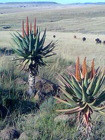
The Eastern Cape gets progressively wetter from west to east. The west is mostly semi-arid Karoo
, except in the far south, which is temperate rainforest in the Tsitsikamma region. The coast is generally rugged with interspersed beaches. Most of the province is hilly to very mountainous between Graaff-Reinet and Rhodes including the Sneeuberge
(English: Snow Mountains), Stormberge
, Winterberge
and Drakensberg
(English: Dragon Mountains). The highest point in the province is Ben Macdhui
at 3001m. The east from East London towards the Kwa-Zulu Natal border – a region known as Transkei
– is lush grassland on rolling hills, punctuated by deep gorges with intermittent forest.
Eastern Cape has a shoreline
in the south on the South Indian Ocean
. In the northeast, it borders the following districts
of Lesotho
:
Domestically, it borders the following provinces:
and Rhodes
.
 The landscape is extremely diverse. The western interior is largely arid Karoo
, while the east is well-watered and green. The Eastern Cape offers a wide array of attractions, including 800 km of untouched and pristine coastline along with some particularly splendid beaches, and "big-five
" viewing in a malaria
-free environment.
The Addo Elephant National Park
, situated 73 km from Port Elizabeth, was proclaimed in 1931. Its 743 km² offers sanctuary to 170 elephants, 400 Cape buffalo and 21 black rhino of the very scarce Kenya
n sub-species.
The province is the location of South Africa's only ski resort, Tiffindell
, which is situated near the hamlet of Rhodes
in the Southern Drakensberg
on the slopes of the highest mountain peak in the Eastern Cape (3001 m).
The National Arts Festival, held in Grahamstown
is Africa's largest and most colourful cultural event, offering a choice of the very best of both indigenous and imported talent. Every year for 11 days the town's population almost doubles, as over 50,000 people flock to the region for a feast of arts, crafts and sheer entertainment.
The Tsitsikamma National Park
is an 80 km long coastal strip between Nature's Valley and the mouth of the Storms River
. In the park the visitor finds an almost untouched natural landscape. Near the park is the Bloukrans Bridge, which is the world's third highest bungee jump.
Jeffreys Bay
is an area with some of the country's wildest coastline, which is backed by some of Africa's most spectacular sub-tropical rainforest. Famous for its "supertubes", probably South Africa's longest and most consistently good wave, it's charged with a surf vibe as relaxed as it is friendly, and this tends to soften the effect of the wealthy set who have made this part of the coast their own.
Aliwal North
, lying on a splendid agricultural plateau on the southern bank of the Orange River
, is one of the country's most popular inland resorts and is famous for its hot springs.
The rugged and unspoilt Wild Coast
is a place of spectacular scenery, and a graveyard for many vessels.
The Alexandria-Grahamstown area produces pineapples, chicory and dairy products, while coffee and tea are cultivated at Magwa. People in the former Transkei region are dependent on cattle, maize and sorghum-farming. An olive nursery has been developed in collaboration with the University of Fort Hare to form a nucleus of olive production in the Eastern Cape.
The basis of the province's fishing industry
is squid, some recreational and commercial fishing for line fish, the collection of marine resources, and access to line-catches of hake.
both have major assembly lines in the Port Elizabeth area, while East London is dominated by the large DaimlerChrysler
plant. The largest construction project in Africa is currently underway at Coega
, about 20 km north of Port Elizabeth, where a new harbour is being built. It is expected that this development will give the province a major economic boost.
With two harbours and three airports offering direct flights to the main centres, and an excellent road and rail infrastructure, the province has been earmarked as a key area for growth and economic development.
Environmentally friendly projects include the Fish River Spatial Development Initiative, the Wild Coast SDI, and two industrial development zones, the West Bank in East London and, near Port Elizabeth, Coega – the largest infrastructure development in post-apartheid South Africa. Plans for the development of the area as an export-orientated zone include the construction of the deepwater Port of Ngqura.
Other important sectors include finance, real estate, business services, wholesale and retail trade, and hotels and restaurants.
Provinces of South Africa
South Africa is currently divided into nine provinces. On the eve of the 1994 general election, South Africa's former homelands, also known as Bantustans, were reintegrated and the four existing provinces were divided into nine. The twelfth, thirteenth and sixteenth amendments to the constitution...
. Its capital is Bhisho, but its two largest cities are Port Elizabeth and East London. It was formed in 1994 out of the "independent" Xhosa homelands of Transkei
Transkei
The Transkei , officially the Republic of Transkei , was a Bantustan—an area set aside for members of a specific ethnicity—and nominal parliamentary democracy in the southeastern region of South Africa...
and Ciskei
Ciskei
Ciskei was a Bantustan in the south east of South Africa. It covered an area of 2,970 square miles , almost entirely surrounded by what was then the Cape Province, and possessed a small coastline along the shore of the Indian Ocean....
, together with the eastern portion of the Cape Province
Cape Province
The Province of the Cape of Good Hope was a province in the Union of South Africa and subsequently the Republic of South Africa...
. Landing place and home of the 1820 settlers, the central and eastern part of the province is the traditional home of the Xhosa people. This region is the birthplace of many prominent South African politicians, such as Nelson Mandela
Nelson Mandela
Nelson Rolihlahla Mandela served as President of South Africa from 1994 to 1999, and was the first South African president to be elected in a fully representative democratic election. Before his presidency, Mandela was an anti-apartheid activist, and the leader of Umkhonto we Sizwe, the armed wing...
, Oliver Tambo
Oliver Tambo
Oliver Reginald Tambo was a South African anti-apartheid politician and a central figure in the African National Congress .-Biography:Oliver Tambo was born in Bizana in eastern Pondoland in what is now Eastern Cape...
, Walter Sisulu
Walter Sisulu
Walter Max Ulyate Sisulu was a South African anti-apartheid activist and member of the African National Congress .-Family and Education:...
, Govan Mbeki
Govan Mbeki
Govan Archibald Mvuyelwa Mbeki was a South African politician, and father of the former South African president Thabo Mbeki and political economist Moeletsi Mbeki...
, Raymond Mhlaba
Raymond Mhlaba
Raymond Mhlaba was an anti-apartheid activist and leader of the African National Congress .Mhlaba spent 25 years of his life in prison. Well known for being sentenced, along with Nelson Mandela, in the Rivonia Trial, he was an active member of the ANC and the South African Communist Party all his...
, Chris Hani
Chris Hani
Chris Hani, born Martin Thembisile Hani was the leader of the South African Communist Party and chief of staff of Umkhonto we Sizwe, the armed wing of the African National Congress . He was a fierce opponent of the apartheid government...
, Thabo Mbeki
Thabo Mbeki
Thabo Mvuyelwa Mbeki is a South African politician who served two terms as the second post-apartheid President of South Africa from 14 June 1999 to 24 September 2008. He is also the brother of Moeletsi Mbeki...
, Steve Biko
Steve Biko
Stephen Biko was a noted anti-apartheid activist in South Africa in the 1960s and 1970s. A student leader, he later founded the Black Consciousness Movement which would empower and mobilize much of the urban black population. Since his death in police custody, he has been called a martyr of the...
and Charles Coghlan
Charles Patrick John Coghlan
Sir Charles Patrick John Coghlan was the first Premier of Southern Rhodesia and held office from October 1, 1923 until his death on August 28, 1927....
.
History
The Eastern Cape as a South African Province came into being in 1994 and incorporated areas from the former Xhosa homelands of the TranskeiTranskei
The Transkei , officially the Republic of Transkei , was a Bantustan—an area set aside for members of a specific ethnicity—and nominal parliamentary democracy in the southeastern region of South Africa...
and Ciskei
Ciskei
Ciskei was a Bantustan in the south east of South Africa. It covered an area of 2,970 square miles , almost entirely surrounded by what was then the Cape Province, and possessed a small coastline along the shore of the Indian Ocean....
, together with what was previously part of the Cape Province
Cape Province
The Province of the Cape of Good Hope was a province in the Union of South Africa and subsequently the Republic of South Africa...
. This resulted in several anomalies including the fact that the Province has four superior courts (at Grahamstown, Port Elizabeth, Bhisho and Mthatha) and enclaves of Kwa-Zulu Natal in the province. The latter anomaly has fallen away with the amendments to municipal and provincial boundaries.
Law and Government
The first premier was Raymond Mhlaba of the African National CongressAfrican National Congress
The African National Congress is South Africa's governing Africanist political party, supported by its tripartite alliance with the Congress of South African Trade Unions and the South African Communist Party , since the establishment of non-racial democracy in April 1994. It defines itself as a...
and current premier of Eastern Cape province is Noxolo Kiviet
Noxolo Kiviet
Noxolo Kiviet is a South African politician who is currently serving as the Premier of the Eastern Cape since 6 May 2009. She is the former speaker of the Eastern Cape Provincial Legislature . She is also a member of the African National Congress....
of the African National Congress
African National Congress
The African National Congress is South Africa's governing Africanist political party, supported by its tripartite alliance with the Congress of South African Trade Unions and the South African Communist Party , since the establishment of non-racial democracy in April 1994. It defines itself as a...
.
Geography
The Eastern Cape gets progressively wetter from west to east. The west is mostly semi-arid Karoo
Karoo
The Karoo is a semi-desert region of South Africa. It has two main sub-regions - the Great Karoo in the north and the Little Karoo in the south. The 'High' Karoo is one of the distinct physiographic provinces of the larger South African Platform division.-Great Karoo:The Great Karoo has an area of...
, except in the far south, which is temperate rainforest in the Tsitsikamma region. The coast is generally rugged with interspersed beaches. Most of the province is hilly to very mountainous between Graaff-Reinet and Rhodes including the Sneeuberge
Sneeuberge
The Sneeuberge are located in the far western portions of the Eastern Cape province of South Africa. They are the highest mountain range in South Africa outside the Drakensberg and stretch between Murraysburg of the neighbouring Western Cape, north of Graaff Reinet and almost to Cradock.They are...
(English: Snow Mountains), Stormberge
Stormberg Mountains
The Stormberg Mountains are a range of mountains situated in the Eastern Cape province of South Africa and are a subsection of the greater Drakensberg mountain range. They form part of the 'Amatola and Stormberg' region which includes major towns like Grahamstown, East London and Port Alfred.Towns...
, Winterberge
Winterberg, Eastern Cape
The Great Winterberg is an extensive east-west mountain range lying immediately north of the small towns of Bedford, Adelaide and Fort Beaufort in the Eastern Cape of South Africa. Elevation on average is about 1800 metres above sea-level. The Great Winterberg Peak north of Adelaide rises to 2371...
and Drakensberg
Drakensberg
The Drakensberg is the highest mountain range in Southern Africa, rising to in height. In Zulu, it is referred to as uKhahlamba , and in Sesotho as Maluti...
(English: Dragon Mountains). The highest point in the province is Ben Macdhui
Ben Macdhui (South Africa)
Ben Macdhui is a mountain in the Eastern Cape province of South Africa. It was named after Ben Macdhui in Scotland. It is the highest peak entirely within the Eastern Cape; KwaDuma is higher, but it lies on the border with Lesotho....
at 3001m. The east from East London towards the Kwa-Zulu Natal border – a region known as Transkei
Transkei
The Transkei , officially the Republic of Transkei , was a Bantustan—an area set aside for members of a specific ethnicity—and nominal parliamentary democracy in the southeastern region of South Africa...
– is lush grassland on rolling hills, punctuated by deep gorges with intermittent forest.
Eastern Cape has a shoreline
Coast
A coastline or seashore is the area where land meets the sea or ocean. A precise line that can be called a coastline cannot be determined due to the dynamic nature of tides. The term "coastal zone" can be used instead, which is a spatial zone where interaction of the sea and land processes occurs...
in the south on the South Indian Ocean
Indian Ocean
The Indian Ocean is the third largest of the world's oceanic divisions, covering approximately 20% of the water on the Earth's surface. It is bounded on the north by the Indian Subcontinent and Arabian Peninsula ; on the west by eastern Africa; on the east by Indochina, the Sunda Islands, and...
. In the northeast, it borders the following districts
Districts of Lesotho
||The Kingdom of Lesotho is divided into ten districts, each headed by a district administrator. Each district has a capital known as a camptown. The districts are further subdivided into 80 constituencies, which consist of 129 local community councils. Most of the districts are named after their...
of Lesotho
Lesotho
Lesotho , officially the Kingdom of Lesotho, is a landlocked country and enclave, surrounded by the Republic of South Africa. It is just over in size with a population of approximately 2,067,000. Its capital and largest city is Maseru. Lesotho is a member of the Commonwealth of Nations. The name...
:
- Mohale's HoekMohale's Hoek DistrictMohale's Hoek is a district of Lesotho. It has an area of 3,530 km² and a population in 2006 of approximately 174,924. Mohale's Hoek is the capital city or camptown, and only town in the district.-Geography:...
– west of Quthing - QuthingQuthing DistrictQuthing is a district of Lesotho. It has an area of 2,916 km² and a population in 2006 of approximately 120,502. Quthing, also known as Moyeni, is the capital of the district or camptown, and the only town in the district...
– between Mohale and Qacha's Nek - Qacha's NekQacha's Nek DistrictQacha's Nek is a district of Lesotho. It has an area of 2,349 km² and a population in 2006 of approximately 71,876. Qacha's Nek is the capital or camptown, and only town in the district.-Geography:...
– east of Quthing
Domestically, it borders the following provinces:
- Western CapeWestern CapeThe Western Cape is a province in the south west of South Africa. The capital is Cape Town. Prior to 1994, the region that now forms the Western Cape was part of the much larger Cape Province...
– west - Northern CapeNorthern CapeThe Northern Cape is the largest and most sparsely populated province of South Africa. It was created in 1994 when the Cape Province was split up. Its capital is Kimberley. It includes the Kalahari Gemsbok National Park, part of an international park shared with Botswana...
– northwest - Free StateFree StateThe Free State is a province of South Africa. Its capital is Bloemfontein, which is also South Africa's judicial capital. Its historical origins lie in the Orange Free State Boer republic and later Orange Free State Province. The current borders of the province date from 1994 when the Bantustans...
– north - KwaZulu-NatalKwaZulu-NatalKwaZulu-Natal is a province of South Africa. Prior to 1994, the territory now known as KwaZulu-Natal was made up of the province of Natal and the homeland of KwaZulu....
– far northeast
Climate
Climate is highly varied. The west is dry with sparse rain during winter of summer, with frosty winters and hot summers. The Tsitsikamma to Grahamstown receives more precipitation, which is also relatively evenly distributed and temperatures are mild. Further east, rainfall becomes more plentiful and humidity increases, becoming more subtropical along the coast with summer rainfall. The interior can become very cold in winter, with heavy snowfalls occasionally occurring in the mountainous regions between MoltenoMolteno, Eastern Cape
Molteno is a town in the Eastern Cape province of South Africa.It was founded in 1874 and named for Sir John Molteno, the first prime minister of the Cape Colony....
and Rhodes
Rhodes, Eastern Cape
Rhodes is a hamlet or small village alongside the trout rich Bell River, near Ben Macdhui in the Drakensberg mountains of the north Eastern Cape, South Africa.- History :...
.
- Port Elizabeth: Jan Max: 25 °C, Min: 18 °C; Jul Max: 20 °C, Min: 9 °C
- MoltenoMolteno, Eastern CapeMolteno is a town in the Eastern Cape province of South Africa.It was founded in 1874 and named for Sir John Molteno, the first prime minister of the Cape Colony....
& Barkly EastBarkly EastBarkly East is a town in Eastern Cape Province, South Africa, seat of the Ukhahlamba District Municipality, and 80 miles by rail E.S.E. of Aliwal North, lying in the mountainous area just south of Lesotho. The town lies at the southern tip of the Drakensberg on the Langkloofspruit, a tributary of...
: Jan Max 28 °C, Min 11 °C; Jul Max: 14 °C, Min: -7 °C
Tourism
Karoo
The Karoo is a semi-desert region of South Africa. It has two main sub-regions - the Great Karoo in the north and the Little Karoo in the south. The 'High' Karoo is one of the distinct physiographic provinces of the larger South African Platform division.-Great Karoo:The Great Karoo has an area of...
, while the east is well-watered and green. The Eastern Cape offers a wide array of attractions, including 800 km of untouched and pristine coastline along with some particularly splendid beaches, and "big-five
Big Five game
The phrase Big Five game was coined by white hunters and refers to the five most difficult animals in Africa to hunt on foot. The term is still used in most tourist and wildlife guides that discuss African wildlife safaris. The collection consists of the lion, African elephant, cape buffalo,...
" viewing in a malaria
Malaria
Malaria is a mosquito-borne infectious disease of humans and other animals caused by eukaryotic protists of the genus Plasmodium. The disease results from the multiplication of Plasmodium parasites within red blood cells, causing symptoms that typically include fever and headache, in severe cases...
-free environment.
The Addo Elephant National Park
Addo Elephant National Park
Addo Elephant National Park is an elephant park situated close to Port Elizabeth in South Africa and is recognized as one of the country's twenty national parks.- History :...
, situated 73 km from Port Elizabeth, was proclaimed in 1931. Its 743 km² offers sanctuary to 170 elephants, 400 Cape buffalo and 21 black rhino of the very scarce Kenya
Kenya
Kenya , officially known as the Republic of Kenya, is a country in East Africa that lies on the equator, with the Indian Ocean to its south-east...
n sub-species.
The province is the location of South Africa's only ski resort, Tiffindell
Tiffindell
Tiffindell Ski Resort is the only ski resort in South Africa.Located in the Southern Drakensberg, South Africa and was established in 1993. The resort is built on Ben Macdhui and has a relatively high elevation of 2810 metres .-Location:...
, which is situated near the hamlet of Rhodes
Rhodes, Eastern Cape
Rhodes is a hamlet or small village alongside the trout rich Bell River, near Ben Macdhui in the Drakensberg mountains of the north Eastern Cape, South Africa.- History :...
in the Southern Drakensberg
Drakensberg
The Drakensberg is the highest mountain range in Southern Africa, rising to in height. In Zulu, it is referred to as uKhahlamba , and in Sesotho as Maluti...
on the slopes of the highest mountain peak in the Eastern Cape (3001 m).
The National Arts Festival, held in Grahamstown
Grahamstown
Grahamstown is a city in the Eastern Cape Province of the Republic of South Africa and is the seat of the Makana municipality. The population of greater Grahamstown, as of 2003, was 124,758. The population of the surrounding areas, including the actual city was 41,799 of which 77.4% were black,...
is Africa's largest and most colourful cultural event, offering a choice of the very best of both indigenous and imported talent. Every year for 11 days the town's population almost doubles, as over 50,000 people flock to the region for a feast of arts, crafts and sheer entertainment.
The Tsitsikamma National Park
Tsitsikamma National Park
The Tsitsikamma National Park is a coastal reserve on the Garden Route in South Africa. It is well known for indigenous forests, dramatic coastline, and the Otter Trail. On 6 March 2009 it was amalgamated with the Wilderness National Park and various other areas of land to form the Garden Route...
is an 80 km long coastal strip between Nature's Valley and the mouth of the Storms River
Storms River
Storms River is a river in the Eastern Cape province of South Africa. The river mouth is located in the Tsitsikamma National Park.- See also :* Tsitsikamma National Park* Paul Sauer Bridge* List of rivers of South Africa...
. In the park the visitor finds an almost untouched natural landscape. Near the park is the Bloukrans Bridge, which is the world's third highest bungee jump.
Jeffreys Bay
Jeffreys Bay
Jeffreys Bay is a town located in the Eastern Cape province of South Africa. The town is situated just off the N2 Highway, about an hour's drive southwest of Port Elizabeth.- History :...
is an area with some of the country's wildest coastline, which is backed by some of Africa's most spectacular sub-tropical rainforest. Famous for its "supertubes", probably South Africa's longest and most consistently good wave, it's charged with a surf vibe as relaxed as it is friendly, and this tends to soften the effect of the wealthy set who have made this part of the coast their own.
Aliwal North
Aliwal North
Aliwal North is a town in central South Africa on the Orange River, Eastern Cape Province. Aliwal North is the seat of the Maletswai Local Municipality which falls within the Ukhahlamba District Municipality....
, lying on a splendid agricultural plateau on the southern bank of the Orange River
Orange River
The Orange River , Gariep River, Groote River or Senqu River is the longest river in South Africa. It rises in the Drakensberg mountains in Lesotho, flowing westwards through South Africa to the Atlantic Ocean...
, is one of the country's most popular inland resorts and is famous for its hot springs.
The rugged and unspoilt Wild Coast
Wild Coast Region, Eastern Cape
The Wild Coast is one of the four regions of the Eastern Cape, a province of South Africa. The region stretches from its border with Buffalo City in the south to the Mthamvuna River near Port Edward in the north...
is a place of spectacular scenery, and a graveyard for many vessels.
Economy
The Eastern Cape was one of the poorest provinces in South Africa. This was largely due to the poverty found in the former homelands, where subsistence agriculture predominates.Agriculture
There is much fertile land in the Eastern Cape, and agriculture is important. The fertile Langkloof Valley in the southwest has enormous deciduous fruit orchards, while sheep farming predominates in the Karoo.The Alexandria-Grahamstown area produces pineapples, chicory and dairy products, while coffee and tea are cultivated at Magwa. People in the former Transkei region are dependent on cattle, maize and sorghum-farming. An olive nursery has been developed in collaboration with the University of Fort Hare to form a nucleus of olive production in the Eastern Cape.
The basis of the province's fishing industry
Fishing industry
The fishing industry includes any industry or activity concerned with taking, culturing, processing, preserving, storing, transporting, marketing or selling fish or fish products....
is squid, some recreational and commercial fishing for line fish, the collection of marine resources, and access to line-catches of hake.
Industry
The two major industrial centres, Port Elizabeth and East London have well-developed economies based on the automotive industry. General Motors and VolkswagenVolkswagen
Volkswagen is a German automobile manufacturer and is the original and biggest-selling marque of the Volkswagen Group, which now also owns the Audi, Bentley, Bugatti, Lamborghini, SEAT, and Škoda marques and the truck manufacturer Scania.Volkswagen means "people's car" in German, where it is...
both have major assembly lines in the Port Elizabeth area, while East London is dominated by the large DaimlerChrysler
DaimlerChrysler
Daimler AG is a German car corporation. By unit sales, it is the thirteenth-largest car manufacturer and second-largest truck manufacturer in the world. In addition to automobiles, Daimler manufactures buses and provides financial services through its Daimler Financial Services arm...
plant. The largest construction project in Africa is currently underway at Coega
Coega
The Coega Industrial Development Zone covering 110 km² of land , is situated in the Nelson Mandela Municipality, Eastern Cape province of South Africa in the Nelson Mandela Metropolitan Municipality near Port Elizabeth...
, about 20 km north of Port Elizabeth, where a new harbour is being built. It is expected that this development will give the province a major economic boost.
With two harbours and three airports offering direct flights to the main centres, and an excellent road and rail infrastructure, the province has been earmarked as a key area for growth and economic development.
Environmentally friendly projects include the Fish River Spatial Development Initiative, the Wild Coast SDI, and two industrial development zones, the West Bank in East London and, near Port Elizabeth, Coega – the largest infrastructure development in post-apartheid South Africa. Plans for the development of the area as an export-orientated zone include the construction of the deepwater Port of Ngqura.
Other important sectors include finance, real estate, business services, wholesale and retail trade, and hotels and restaurants.
Municipalities
The Eastern Cape Province is divided into 38 local municipalities and one metropolitan municipality:
|
Amatole District Municipality Amathole is one of the 7 districts of Eastern Cape province of South Africa. The seat of Amathole is East London. Over 90% of its 1 664 259 people speak Xhosa . The district code is DC12...
|
Cacadu District Municipality Cacadu District Municipality is situated in the Western Portion of the Eastern Cape province, covering an area of 58 242 square kilometres. The area of the district municipality includes nine local municipalities and other portions collectively known as the District Management Areas . The seat of...
|
Chris Hani District Municipality Chris Hani is one of the 7 districts of Eastern Cape province of South Africa. The seat of Chris Hani is Queenstown. The majority of its 810 274 people speak Xhosa , although Afrikaans speaking people predominate in the far west of the district...
|
OR Tambo District Municipality OR Tambo is one of the 7 districts of Eastern Cape province of South Africa. The seat of OR Tambo is Mthatha . The vast majority of its 1 676 463 people speak Xhosa . The district is named after Oliver Tambo...
|
Ukhahlamba District Municipality Joe Gqabi is one of the 7 districts of Eastern Cape province of South Africa. The seat of Joe Gqabi is Barkly East. The majority of its 341 337 people speak IsiXhosa . The district code is DC14...
|
Education
- Universities
- Comprehensive Nelson Mandela Metropolitan UniversityNelson Mandela Metropolitan UniversityNelson Mandela Metropolitan University is a South African tertiary education institution with its main administration in the coastal city of Port Elizabeth. The merger creating the NMMU was realized in January 2005 but its history dates back to 1882 with the foundation of Port Elizabeth Art School...
(Port Elizabeth) - Rhodes UniversityRhodes UniversityRhodes University is a public research university located in Grahamstown in the Eastern Cape Province of South Africa, established in 1904. It is the province’s oldest university, and is one of the four universities in the province...
(GrahamstownGrahamstownGrahamstown is a city in the Eastern Cape Province of the Republic of South Africa and is the seat of the Makana municipality. The population of greater Grahamstown, as of 2003, was 124,758. The population of the surrounding areas, including the actual city was 41,799 of which 77.4% were black,...
) - University of Fort HareUniversity of Fort HareThe University of Fort Hare is a public university in Alice, Eastern Cape, South Africa. It was a key institution in higher education for black Africans from 1916 to 1959. It offered a Western-style, academically excellent education to students from across sub-Saharan Africa, creating a black...
(AliceAlice, Eastern CapeAlice, a town in South Africa, is named after Princess Alice, daughter of the British Queen Victoria. Many of the current political leaders in South Africa were educated at the University of Fort Hare, also the alma mater of former President Nelson Mandela...
) - Walter Sisulu University for Technology and ScienceWalter Sisulu University for Technology and ScienceWalter Sisulu University is a university of technology in Mthatha,Eastern Cape, South Africa, which came into existence on 1 July 2005 as a result of a merger between Border Technikon, Eastern Cape Technikon and the University of Transkei....
(Buffalo City, Butterworth, MthathaMthathaMthatha is the main town of the King Sabata Dalindyebo Local Municipality in Eastern Cape province of South Africa. The town has an airport, previously known by the name K. D. Matanzima Airport after former leader Kaiser Matanzima....
, QueenstownQueenstown, Eastern CapeQueenstown, named after Queen Victoria, is a town in the middle of the Eastern Cape Province of South Africa, roughly half way in between the towns of Cathcart and Sterkstroom. It is currently the commercial, administrative, and educational centre of the prosperous surrounding farming district...
)
- Comprehensive Nelson Mandela Metropolitan University
- Other educational institutions
- Port Elizabeth College
Sports
- Soccer
- Bay United F.C. (Port Elizabeth)
- Cricket
- Chevrolet WarriorsWarriors cricket teamThe Chevrolet Warriors is the name used by the combined Eastern Province and Border first class cricket teams in South Africa. The home venues of the Warriors are St George's Park, Port Elizabeth and Buffalo Park, East London....
(Port Elizabeth)
- Chevrolet Warriors
- Rugby
- Mighty ElephantsMighty ElephantsThe Eastern Province Kings are a South African rugby union team that participates in the annual Currie Cup and Vodacom Cup tournaments and are governed by the Eastern Province Rugby Union...
(Port Elizabeth) - Border BulldogsBorder BulldogsThe Border Bulldogs are a South African rugby union team that participates in the annual Currie Cup tournament. They are governed by the Border Rugby Union and are based in East London....
(East London) - Southern KingsSouthern KingsThe Southern Kings are a South African rugby union franchise. The franchise was formally announced at the opening of the Nelson Mandela Bay Stadium on 16 June 2009, in time to coincide with the 2009 British and Irish Lions tour to South Africa....
(Port Elizabeth)
- Mighty Elephants