
Hardap Region
Encyclopedia
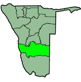
Hardap is one of the thirteen regions of Namibia
. It is home to the Hardap Dam
.
Hardap stretches the entire width of Namibia, from the Atlantic Ocean
in the west to Namibia's eastern national border. In the northeast, it borders the Kgalagadi District of Botswana
, and in the southeast, it borders the Northern Cape
Province of South Africa
. Domestically, it borders the following regions:
of Namibia for declaring Hardap Region "SWAPO territory" and urging supporters not to allow other political parties to "invade" the region. In the 2004 Presidential election, the region supported Hifikepunye Pohamba
of SWAPO with a narrow majority of the votes (52%), following by Ben Ulenga
of Congress of Democrats
(21%) and Katuutire Kaura
of the Democratic Turnhalle Alliance (16%). Four other candidates combined for the 11%. The region comprises six political constituencies
: Gibeon, Rehoboth Rural
, Rehoboth West Urban
, Rehoboth East Urban
, Mariental Urban
and Mariental Rural
.
 According to the Namibia 2001 Population and Housing Census, Hardap had a population of 68,249 (33,665 females and 34,579 males or 103 males for every 100 females) growing at an annual rate of 0.3%. The fertility rate was 3.6 children per woman. 46% lived in urban areas while 54% lived in rural areas, and with an area of 109,651km2, the population density was 0.6 persons per km2. By age, 13% of the population was under 5 years old, 23% between 5-14 years, 55% between 15-59 years, and 8% 60 years and older. The population was divided into 15,039 households, with an average size of 4.4 persons. 34% of households had a female head of house, while 66% had a male. For those 15 years and older, 54% had never married, 30% married with certificate, 1% married traditionally, 9% married concensually, 2% were divorced or separated, and 4% were widowed.
The most commonly spoken languages at home were Afrikaans
(44% of households), and Nama
/Damara (44%). For those 15 years and older, the literacy rate was 83%. In terms of education, 84% of girls and 83% of boys between the ages of 6-15 were attending school, and of those older than 15, 73% had left school, 9% were currently at school, and 13% had never attended.
The employment rate for the labor force (64% of those 15+) was 66% employed and 34% unemployed. For those 15+ years old and not in the labor force (29%), 29% were students, 37% homeakers, and 33% retired, too old, etc.
Among households, 95% had safe water, 34% no toilet facility, 51% electricity for lighting, 77% access to radio
, and 20% had wood or charcoal for cooking. In terms of household's main sources of income, 9% derived it from farming, 61% from wages and salaries, 7% cash remittances, 5% from business or non-farming, and 15% from pension.
For every 1000 live births there were 62 female infant deaths and 64 male. The life expectancy at birth was 53 years for females and 51 for males. Among children younger than 15, 4% had lost a mother, 6% a father, and 1% were orphaned by both parents. 6% of the entire population had a disability, of which 19% were deaf, 47% blind, 7% had a speech disability, 10% hand disability, 28% leg disability, and 6% mental disability.
Regions of Namibia
The administrative division of Namibia is tabled by Delimitation Commissions and accepted or declined by the National Assembly. The First Delimitation Commission chaired by Judge President Johan Strydom suggested in 1992 that Namibia be divided into 13 Regions, a number that has not been amended...
. It is home to the Hardap Dam
Hardap Dam
Hardap Dam is a dam close to Mariental, Hardap Region, Namibia. Created in 1962 while Namibia was under South African occupation, Hardap Dam is the largest Dam in the country. The reservoir dams the Fish River and has a surface area of 25 km²...
.
Hardap stretches the entire width of Namibia, from the Atlantic Ocean
Atlantic Ocean
The Atlantic Ocean is the second-largest of the world's oceanic divisions. With a total area of about , it covers approximately 20% of the Earth's surface and about 26% of its water surface area...
in the west to Namibia's eastern national border. In the northeast, it borders the Kgalagadi District of Botswana
Botswana
Botswana, officially the Republic of Botswana , is a landlocked country located in Southern Africa. The citizens are referred to as "Batswana" . Formerly the British protectorate of Bechuanaland, Botswana adopted its new name after becoming independent within the Commonwealth on 30 September 1966...
, and in the southeast, it borders the Northern Cape
Northern Cape
The Northern Cape is the largest and most sparsely populated province of South Africa. It was created in 1994 when the Cape Province was split up. Its capital is Kimberley. It includes the Kalahari Gemsbok National Park, part of an international park shared with Botswana...
Province of South Africa
South Africa
The Republic of South Africa is a country in southern Africa. Located at the southern tip of Africa, it is divided into nine provinces, with of coastline on the Atlantic and Indian oceans...
. Domestically, it borders the following regions:
- ErongoErongo RegionErongo is one of the 13 regions of Namibia. It comprises the Swakopmund magisterial district up to the Ugab River and includes Walvis Bay, Omaruru and Karibib magisterial districts. This region is named after Erongo mountain, a well known landmark in Namibia and in this area...
- northwest - KhomasKhomas RegionKhomas is one of the thirteen regions of Namibia. It contains the capital city Windhoek and provides for this reason superior transportation infrastructure. It has well-developed economical, financial, and trade sectors. Khomas Region occupies 4.5% of the land area of Namibia but has the highest...
- north central - OmahekeOmahekeOmaheke is one of the thirteen regions of Namibia. Omaheke lies on the eastern border of Namibia and is the Western extension of the Kalahari desert. The name Omaheke is the Herero word for Sandveld. A large part of this region is known as the Sandveld...
- northeast - KarasKaras RegionThe Karas Region is the southernmost region of Namibia. The name assigned to the region reflects the prominence of the Karas mountain range in its southern part...
- south
Politics
The Governor of Hardap Region is Katrina Hanse-Himarwa, a member of SWAPO. In February 2009, Hanse-Himarwa was condemned by the National Society for Human RightsNational Society for Human Rights
The National Society for Human Rights is a Saudi Arabian human rights organisation closely associated with the Saudi government and established on 10 March 2004, two years after the Human Rights First Society applied unsuccessfully for a licence...
of Namibia for declaring Hardap Region "SWAPO territory" and urging supporters not to allow other political parties to "invade" the region. In the 2004 Presidential election, the region supported Hifikepunye Pohamba
Hifikepunye Pohamba
Hifikepunye Lucas Pohamba is the second and current President of Namibia. He won the 2004 and 2009 presidential elections overwhelmingly as the candidate of the South West Africa People's Organisation ruling party, taking office in March 2005. He has also been the President of SWAPO since...
of SWAPO with a narrow majority of the votes (52%), following by Ben Ulenga
Ben Ulenga
Benjamin Ulenga is a Namibian politician. A member of the National Assembly of Namibia, he is the President of the Congress of Democrats , an opposition political party....
of Congress of Democrats
Congress of Democrats
The Congress of Democrats is a political party in Namibia, led by Ben Ulenga. It is an opposition party represented in the National Assembly.The party is an observer of the Socialist International.- 2004 elections :...
(21%) and Katuutire Kaura
Katuutire Kaura
Katuutire Kaura is a Namibian politician. He has been President of the Democratic Turnhalle Alliance since 1998 and was Leader of the Official Opposition from 2000 to 2005.Kaura was born in Ombujondjupa, Otjozondjupa Region...
of the Democratic Turnhalle Alliance (16%). Four other candidates combined for the 11%. The region comprises six political constituencies
Constituencies of Namibia
Each of the 13 regions in Namibia are further subdivided into electoral constituencies. The number and size of each constituency varies with the size and population of each region. There are currently 107 constituencies in Namibia...
: Gibeon, Rehoboth Rural
Rehoboth Rural
Rehoboth Rural is a constituency in the Hardap region of Namibia. It has a population of 7365. Among the settlements in Rehoboth Rural are Klein Aub, Khauxas, and Schlip.-2009:...
, Rehoboth West Urban
Rehoboth West Urban
Rehoboth Urban West is an electoral constituency in the Hardap region of Namibia, comprising the suburbs of Rehoboth that are situated to the west of the national road B1. It has a population of 9201.- References :...
, Rehoboth East Urban
Rehoboth East Urban
Rehoboth Urban East is an electoral constituency in the Hardap region of Namibia, comprising the suburbs of Rehoboth that are situated to the east of the national road B1. It has a population of 12,581.- References :...
, Mariental Urban
Mariental Urban
Mariental Urban is a constituency in the Hardap region of Namibia. It has a population of 11,977....
and Mariental Rural
Mariental Rural
Mariental Rural is a constituency in the Hardap region of Namibia. It has a population of 13,596....
.
Demographics
The most commonly spoken languages at home were Afrikaans
Afrikaans
Afrikaans is a West Germanic language, spoken natively in South Africa and Namibia. It is a daughter language of Dutch, originating in its 17th century dialects, collectively referred to as Cape Dutch .Afrikaans is a daughter language of Dutch; see , , , , , .Afrikaans was historically called Cape...
(44% of households), and Nama
Nama language
The Khoekhoe language, or Khoekhoegowab, also known by the ethnic term Nàmá and previously the now-discouraged term Hottentot, is the most widespread of the Khoisan languages. It belongs to the Khoe language family, and is spoken in Namibia, Botswana, and South Africa by three ethnic groups, the...
/Damara (44%). For those 15 years and older, the literacy rate was 83%. In terms of education, 84% of girls and 83% of boys between the ages of 6-15 were attending school, and of those older than 15, 73% had left school, 9% were currently at school, and 13% had never attended.
The employment rate for the labor force (64% of those 15+) was 66% employed and 34% unemployed. For those 15+ years old and not in the labor force (29%), 29% were students, 37% homeakers, and 33% retired, too old, etc.
Among households, 95% had safe water, 34% no toilet facility, 51% electricity for lighting, 77% access to radio
Radio
Radio is the transmission of signals through free space by modulation of electromagnetic waves with frequencies below those of visible light. Electromagnetic radiation travels by means of oscillating electromagnetic fields that pass through the air and the vacuum of space...
, and 20% had wood or charcoal for cooking. In terms of household's main sources of income, 9% derived it from farming, 61% from wages and salaries, 7% cash remittances, 5% from business or non-farming, and 15% from pension.
For every 1000 live births there were 62 female infant deaths and 64 male. The life expectancy at birth was 53 years for females and 51 for males. Among children younger than 15, 4% had lost a mother, 6% a father, and 1% were orphaned by both parents. 6% of the entire population had a disability, of which 19% were deaf, 47% blind, 7% had a speech disability, 10% hand disability, 28% leg disability, and 6% mental disability.