
Richtersveld
Encyclopedia
The Richtersveld is a mountainous desert
landscape characterised by rugged kloofs and high mountains, situated in South Africa
’s Northern Cape
province. It is full of changing scenery from flat sandy plains, to craggy sharp mountains of volcanic rock and the lushness of the Orange River
, which forms the border with neighbouring Namibia
. The park ranges in altitude from less than 60m (less than 200 feet) in its far North, along the Orange river, to 1377 m (4518 feet) at Cornellberg somewhat South of centre.
Located in South Africa's northern Namaqualand
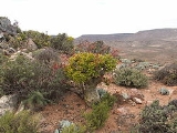
, this arid area represents a harsh landscape where water is a great scarcity and only the hardiest of lifeforms survive. Despite this, the Richtersveld is regarded as the only Arid Biodiversity Hotspot on Earth, with an astonishing variety of plant, bird and animal life (much of which is endemic).
A favourite amongst nature travellers to South Africa, the landscape is sometimes described as "martian
". Though barren and desolate at first glance, closer examination reveals the area to be rich in desert lifeforms, with an array or unique species specially adapted for survival.
Temperatures are extreme, and in summer can reach over 50°C. Rain is a very rare event.
The northern part of the area was proclaimed as a National Park in 1991 after 18 years of negotiation with the local Nama
people, who continue to live and graze their livestock in the area. It has an area of 1,624.45 square kilometres.
In June 2007, the "Richtersveld Cultural and Botanical Landscape", just to the south of the National Park and an area of equivalent size and beauty, was named a UNESCO
World Heritage Site
. Unlike the National Park, the Richtersveld Community Conservancy http://www.richtersveld-conservancy.org, which forms the core zone of the World Heritage Site, is not subject to diamond mining and is as a result the more pristine of the two areas.
and represents an example of one of the most interesting mega-ecosystems in the world, the Karoo
.
namaquanum Welw.). Literally translated, this means "half-person tree" and the name comes from the tree's resemblance to the human form; its top consists of a grouping of thick, crinkled leaves, which can make it look almost like a human head.
These trees are revered by the indigenous Nama
people as the embodiment of their ancestors, half human, half plant, mourning for their ancient Namibian home.
Also found here are gnarled quiver trees, tall aloes and a variety of other succulents.
Desert
A desert is a landscape or region that receives an extremely low amount of precipitation, less than enough to support growth of most plants. Most deserts have an average annual precipitation of less than...
landscape characterised by rugged kloofs and high mountains, situated in South Africa
South Africa
The Republic of South Africa is a country in southern Africa. Located at the southern tip of Africa, it is divided into nine provinces, with of coastline on the Atlantic and Indian oceans...
’s Northern Cape
Northern Cape
The Northern Cape is the largest and most sparsely populated province of South Africa. It was created in 1994 when the Cape Province was split up. Its capital is Kimberley. It includes the Kalahari Gemsbok National Park, part of an international park shared with Botswana...
province. It is full of changing scenery from flat sandy plains, to craggy sharp mountains of volcanic rock and the lushness of the Orange River
Orange River
The Orange River , Gariep River, Groote River or Senqu River is the longest river in South Africa. It rises in the Drakensberg mountains in Lesotho, flowing westwards through South Africa to the Atlantic Ocean...
, which forms the border with neighbouring Namibia
Namibia
Namibia, officially the Republic of Namibia , is a country in southern Africa whose western border is the Atlantic Ocean. It shares land borders with Angola and Zambia to the north, Botswana to the east and South Africa to the south and east. It gained independence from South Africa on 21 March...
. The park ranges in altitude from less than 60m (less than 200 feet) in its far North, along the Orange river, to 1377 m (4518 feet) at Cornellberg somewhat South of centre.
Located in South Africa's northern Namaqualand
Namaqualand
Namaqualand is an arid region of Namibia and South Africa, extending along the west coast over and covering a total area of 170,000 square miles/440,000 km². It is divided by the lower course of the Orange River into two portions - Little Namaqualand to the south and Great Namaqualand to the...
, this arid area represents a harsh landscape where water is a great scarcity and only the hardiest of lifeforms survive. Despite this, the Richtersveld is regarded as the only Arid Biodiversity Hotspot on Earth, with an astonishing variety of plant, bird and animal life (much of which is endemic).
A favourite amongst nature travellers to South Africa, the landscape is sometimes described as "martian
Martian
As an adjective, the term martian is used to describe anything pertaining to the planet Mars.However, a Martian is more usually a hypothetical or fictional native inhabitant of the planet Mars. Historically, life on Mars has often been hypothesized, although there is currently no solid evidence of...
". Though barren and desolate at first glance, closer examination reveals the area to be rich in desert lifeforms, with an array or unique species specially adapted for survival.
Temperatures are extreme, and in summer can reach over 50°C. Rain is a very rare event.
The northern part of the area was proclaimed as a National Park in 1991 after 18 years of negotiation with the local Nama
Namaqua
Nama are an African ethnic group of South Africa, Namibia and Botswana. They traditionally speak the Nama language of the Khoe-Kwadi language family, although many Nama now speak Afrikaans. The Nama are the largest group of the Khoikhoi people, most of whom have largely disappeared as a group,...
people, who continue to live and graze their livestock in the area. It has an area of 1,624.45 square kilometres.
In June 2007, the "Richtersveld Cultural and Botanical Landscape", just to the south of the National Park and an area of equivalent size and beauty, was named a UNESCO
UNESCO
The United Nations Educational, Scientific and Cultural Organization is a specialized agency of the United Nations...
World Heritage Site
World Heritage Site
A UNESCO World Heritage Site is a place that is listed by the UNESCO as of special cultural or physical significance...
. Unlike the National Park, the Richtersveld Community Conservancy http://www.richtersveld-conservancy.org, which forms the core zone of the World Heritage Site, is not subject to diamond mining and is as a result the more pristine of the two areas.
Climate
The climate here is harsh with temperatures of up to 53 °C having been recorded in mid-summer. Nights are cool and bring with them heavy dew. This unique climate is what has fostered such a unique ecosystem."Malmokkies"
With water so scarce, life in the Richtersveld depends on moisture from the early morning fog. Locals call it 'Ihuries' or 'Malmokkies' and it makes survival possible for a range of small reptiles, birds and mammals.Wildlife
The park boasts excellent bird watching opportunities, as well as a diverse range of animals including grey rhebok, duiker, steenbok, klipspringer, kudu, Hartman’s mountain zebra, baboon, vervet monkey, caracal and leopard.Plant life
Home to c. 650 plant species, this park boasts the world’s largest diversity of succulentsSucculent plant
Succulent plants, also known as succulents or fat plants, are water-retaining plants adapted to arid climates or soil conditions. Succulent plants store water in their leaves, stems, and also in roots...
and represents an example of one of the most interesting mega-ecosystems in the world, the Karoo
Karoo
The Karoo is a semi-desert region of South Africa. It has two main sub-regions - the Great Karoo in the north and the Little Karoo in the south. The 'High' Karoo is one of the distinct physiographic provinces of the larger South African Platform division.-Great Karoo:The Great Karoo has an area of...
.
Odd vegetation
The area is home to a number of rather unusual plants, many of which are found nowhere else on earth. Chief among these is the "Halfmensboom" (PachypodiumPachypodium
Pachypodium is a genus of succulent spine-bearing trees and shrubs, native to Africa. It belongs to the dogbane family, Apocynaceae. Pachypodium comes from a Latin form from Greek pachus and podion , hence meaning thick-footed.-Genus characteristics:All Pachypodium are succulent plants that...
namaquanum Welw.). Literally translated, this means "half-person tree" and the name comes from the tree's resemblance to the human form; its top consists of a grouping of thick, crinkled leaves, which can make it look almost like a human head.
These trees are revered by the indigenous Nama
Namaqua
Nama are an African ethnic group of South Africa, Namibia and Botswana. They traditionally speak the Nama language of the Khoe-Kwadi language family, although many Nama now speak Afrikaans. The Nama are the largest group of the Khoikhoi people, most of whom have largely disappeared as a group,...
people as the embodiment of their ancestors, half human, half plant, mourning for their ancient Namibian home.
Also found here are gnarled quiver trees, tall aloes and a variety of other succulents.
Culture
The area is inhabited by Nama and other peoples. The local community, which owns the entire area, manages the National Park in conjunction with South African National Parks and is entirely responsible for management of the World Heritage Site. Both areas are used by traditional nomadic herders to practice their ancient lifestyle and culture. It is the last place where the traditional way of life of the KhoiKhoi (of whom the Nama are the surviving clan), who once occupied the entire south-western part of Africa, survives to any great extent.See also
- Ai-Ais/Richtersveld Transfrontier ParkAi-Ais/Richtersveld Transfrontier ParkThe ǀAi-ǀAis/Richtersveld Transfrontier Park is a peace park straddling the border between South Africa and Namibia. It was formed in 2003 by combining the Namibian ǀAi-ǀAis Hot Springs Game Park and the South African Richtersveld National Park....
- List of national parks
- Ai-Ais Hot SpringsAi-Ais Hot SpringsAi-Ais Hot Springs meaning 'burning water' in the local Nama language, refers to the sulphurous thermal hot water springs found in the area. Pronounced "eye-ice", the natural hot-spring oasis is situated at the base of the mountain peaks at the southern end of Fish River Canyon, in the Karas Region...
External links
- Richtersveld National Park and the Orange River
- Ai-|Ais/Richtersveld Transfrontier National Park
- The Richtersveld Community Conservancy, core of the World Heritage Site
- A mini travel portal for those considering to visit the Richtersveld.
- The Richtersveld Municipality website.