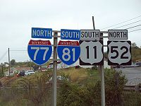
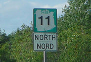
Reassurance marker
Encyclopedia
Direction, position, or indication sign
A direction sign, more fully defined as a direction, position, or indication sign by the Vienna Convention on Road Signs and Signals, is any road sign used primarily to give information about the location of either the driver or possible destinations, and are considered a subset of the informative...
that repeats the name or number of the current route. Typically posted at intervals alongside a numbered highway, the signs are intended to reassure drivers that they are traveling on the desired road (or to inform them that they are not).
North America
Highway shield
A highway shield is a sign denoting the route number of a highway, usually in the form of a symbolic shape with the route number enclosed. As the focus of the sign, the route number is usually the sign's largest element, with other items on the sign rendered in smaller sizes or contrasting colours...
displaying the road number
Road number
A road number is often assigned to a stretch of public roadway. The number chosen is often dependent on the type of road, with numbers differentiating between interstates, motorways, arterial thoroughfares, two-lane roads, and so forth.-United Kingdom:...
on an elevated pole, with a plate above or below it indicating the "official" direction of that side of the route. (The official long-range direction may differ from the short-range direction; for example, a large stretch of I-90
New York State Thruway
The New York State Thruway is a system of limited-access highways located within the state of New York in the United States. The system, known officially as the Governor Thomas E. Dewey Thruway for former New York Governor Thomas E. Dewey, is operated by the New York State Thruway Authority and...
near Buffalo, New York
Buffalo, New York
Buffalo is the second most populous city in the state of New York, after New York City. Located in Western New York on the eastern shores of Lake Erie and at the head of the Niagara River across from Fort Erie, Ontario, Buffalo is the seat of Erie County and the principal city of the...
runs north-south, although the route is officially east-west.) The direction portion of the sign confirms that the driver is going the right way along the desired road. On larger roads, reassurance markers are sometimes posted on a sign that is elevated on a gantry
Gantry (road sign)
A gantry is a traffic sign assembly in which signs are mounted on an overhead support, or railway signals supported....
.
In the United States, reassurance shields are defined in Section 2D.31 of the Manual on Uniform Traffic Control Devices
Manual on Uniform Traffic Control Devices
The Manual on Uniform Traffic Control Devices is a document issued by the Federal Highway Administration of the United States Department of Transportation to specify the standards by which traffic signs, road surface markings, and signals are designed, installed, and used...
(MUTCD). The MUTCD recommends that reassurance assemblies be placed:
- 25–200 feet (8–61 m) after intersections of numbered highways
- Between intersections in urban areas as needed
- After leaving the limits of any incorporated city or town
- Periodically in other places for reassurance purposes
The MUTCD requires a cardinal directional sign to be posted with the route shield to further reassure travelers that they are traveling the correct direction on their route. However, this standard is not always followed, especially in urban areas. One example of this is found in the Hampton Roads
Hampton Roads
Hampton Roads is the name for both a body of water and the Norfolk–Virginia Beach metropolitan area which surrounds it in southeastern Virginia, United States...
area of Virginia, where directional signs for Interstate 64
Interstate 64 in Virginia
In the U.S. state of Virginia, Interstate 64 runs east–west through the middle of the state from West Virginia to the Hampton Roads region, a total of . It is notable for crossing the mouth of the harbor of Hampton Roads on the Hampton Roads Bridge-Tunnel, the first bridge-tunnel to...
are not posted between the road's eastern terminus in Chesapeake
Chesapeake, Virginia
As of the census of 2000, there were 199,184 people, 69,900 households, and 54,172 families residing in the city. The population density was 584.6 people per square mile . There were 72,672 housing units at an average density of 213.3 per square mile...
and Interstate 264
Interstate 264 (Virginia)
Interstate 264 is an Interstate Highway in the U.S. state of Virginia. It runs from a junction with Interstate 64 and Interstate 664 near Bowers Hill in Chesapeake east into Portsmouth and through the Downtown Tunnel under the South Branch of the Elizabeth River into Norfolk...
in Norfolk
Norfolk, Virginia
Norfolk is an independent city in the Commonwealth of Virginia in the United States. With a population of 242,803 as of the 2010 Census, it is Virginia's second-largest city behind neighboring Virginia Beach....
, because the road travels in the opposite compass direction from its official designation (although the route in the Norfolk-to-Chesapeake direction is a continuation of I-64 east, it travels westward at that point).
Australia
Australia has followed different trends pertaining to highway shields. Alpha-numeric route numbering has been in use in TasmaniaTasmania
Tasmania is an Australian island and state. It is south of the continent, separated by Bass Strait. The state includes the island of Tasmania—the 26th largest island in the world—and the surrounding islands. The state has a population of 507,626 , of whom almost half reside in the greater Hobart...
since the 1970s, but in 1996 states on the mainland began conversion to the alpha-numeric system. The state of Victoria
Victoria (Australia)
Victoria is the second most populous state in Australia. Geographically the smallest mainland state, Victoria is bordered by New South Wales, South Australia, and Tasmania on Boundary Islet to the north, west and south respectively....
was the first to implement the policy. Prior to this conversion and concurrently, Federal Highway (gold-on-green squared-off bullet), National Highway (black-on-white squared-off bullet), State Highway (blue bullet), and Tourist Route (white-on-brown rounded isosceles trapezoid
Isosceles trapezoid
In Euclidean geometry, an isosceles trapezoid is a convex quadrilateral with a line of symmetry bisecting one pair of opposite sides, making it automatically a trapezoid...
) shields existed. In Victoria, Freeway shields were used (white-on-green with "F" prefix) until the late 1980s, while during the 1990s Queensland
Queensland
Queensland is a state of Australia, occupying the north-eastern section of the mainland continent. It is bordered by the Northern Territory, South Australia and New South Wales to the west, south-west and south respectively. To the east, Queensland is bordered by the Coral Sea and Pacific Ocean...
and New South Wales
New South Wales
New South Wales is a state of :Australia, located in the east of the country. It is bordered by Queensland, Victoria and South Australia to the north, south and west respectively. To the east, the state is bordered by the Tasman Sea, which forms part of the Pacific Ocean. New South Wales...
implemented a hexagonal blue-on-white Metroad
Metroad
Metroads are the primary road routes serving the Sydney and Brisbane metropolitan areas in Australia. The Metroads form a network of radial and circumferential routes throughout the city, lengths of some of which are of freeway grade.-History:...
system of urban arterial routes. When it opened, the M80 Ring Road
M80 Ring Road, Melbourne
The M80 Ring Road, more formally known as the Western Ring Road or Metropolitan Ring Road, is a freeway in Melbourne, Australia connecting the northern suburbs and the western suburbs to various freeways:* the Hume Freeway;...
used a shield similar to that of the U.S. Interstate Highway shield, with "Ring Road" written instead of "Interstate" and with two peaks rather than three.
With the introduction of the alpha-numeric system, roads that are Federally funded (Federal Highways) have a squared-off bullet encompassing the alpha-numeric designation. Freeways and dual-carriageway roads often use an "M" prefix, particularly in Victoria. In addition, trapezoidal signs are placed every 5 km on major regional highways and freeways indicating the distance to the post office of the next city or major town on the route. These signs usually only have the first letter of the destination; two or three letters are used if there is ambiguity between nearby towns or when the place name consists of two words.


New Zealand
Similar to prevalent route numbering in the Pacific region, New Zealand routes are similar to the bullet-shaped markers used in Hong Kong, but are red rather than yellow.Europe
Vienna Convention on Road Signs and Signals
The Vienna Convention on Road Signs and Signals is an international treaty designed to increase road safety and aid international road traffic by standardising the signing system for road traffic in use internationally.This convention was agreed upon by the United Nations Economic and Social...
specifies that "road identification signs" consist of the route number framed in a rectangle, a shield, or the relevant state's route classification symbol (if one exists). The extent to which such signs are used varies between countries.
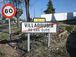
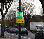
In the Republic of Ireland
Republic of Ireland
Ireland , described as the Republic of Ireland , is a sovereign state in Europe occupying approximately five-sixths of the island of the same name. Its capital is Dublin. Ireland, which had a population of 4.58 million in 2011, is a constitutional republic governed as a parliamentary democracy,...
, such signs appear normally on national routes
Roads in Ireland
The island of Ireland, comprising Northern Ireland and the Republic of Ireland, has an extensive network of tens of thousands of kilometres of public roads, usually surfaced. These roads have been developed and modernised over centuries, from trackways suitable only for walkers and horses, to...
and upgraded regional roads
Regional road
A regional road in Ireland is a class of road not forming a major route , but nevertheless forming a link in the national route network. There are over 11,600 kilometres of regional roads. Regional roads are numbered with three digit route numbers, prefixed by "R" A regional road in Ireland is a...
. Officially known as route confirmation signs, there are two variants; the smaller (featuring just the road number) is common after minor junctions, and a full route confirmation sign will feature the route number and several destinations and the distances to them (with distances not directly reached by that particular route number in brackets). Euroroute numbers have begun to appear on these signs but are not yet commonplace. On motorways and high quality dual carriageways, they appear after every junction (except on the M50
M50 motorway (Ireland)
The M50 motorway is a motorway in Ireland running in a C-shaped ring around the north-eastern, northern, western and southern sides of the capital city, Dublin. The northern end of the route is located at the entrance to the Dublin Port Tunnel. Anti-clockwise it heads northwest through the tunnel...
, on which they are not typically used). On other national, roads they appear when leaving built-up areas. Some regional roads feature route confirmation signs, but they are not common on these roads.
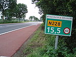
In the Netherlands, frequently-positioned hectometer posts include the route number, the distance in hectometers, and the current speed limit
Speed limit
Road speed limits are used in most countries to regulate the speed of road vehicles. Speed limits may define maximum , minimum or no speed limit and are normally indicated using a traffic sign...
. In some European countries, distance posts similar to milestone
Milestone
A milestone is one of a series of numbered markers placed along a road or boundary at intervals of one mile or occasionally, parts of a mile. They are typically located at the side of the road or in a median. They are alternatively known as mile markers, mileposts or mile posts...
s are placed at regular intervals along roadsides. As well as giving the distance to or from one end of the route, these posts include the route number.