
Mingo National Wildlife Refuge
Encyclopedia
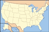
The Mingo National Wildlife Refuge is a 21,676 acre (87.7 km2) National Wildlife Refuge
located in northwestern Stoddard
and southeastern Wayne
counties in Missouri
. Its southwesternmost portion lies on the shores of Lake Wappapello
. Named after the Mingo tribe
, it was established to preserve bottomland hardwoods as well as provide waterfowl and other migratory birds in the Mississippi Flyway
with nesting, feeding, brooding, and resting habitat.
The refuge is maintained with a nine person staff with a fiscal year 2004 budget of $1.2 million.
 In 1804, the United States acquired this territory in the Louisiana Purchase
. At that time, the population of the entire Bootheel
was sparse and the swamp area was considered inaccessible. When Missouri became a state in 1821, all of the counties in southeast Missouri had settlers, except Stoddard
and Dunklin
counties, although Cape Girardeau was one of the most important river towns in Missouri.
Settlers first came to the swamp because of the vast cypress
and tupelo
forests. The giant cypress trees were the first to be used for railroad ties and building lumber. The T.J. Moss Tie Company was a large Bootheel lumbering operation, with its headquarters in Puxico, Missouri
. By 1888, T.J. Moss was the largest tie contractor in the state, and many of their ties were cut from trees taken from the swamp. A large mill was operated just north of Puxico on land now within Mingo NWR. Local sources claim that, at one time, the mill was the largest bandsaw mill in America. The lumber industry reached peak production in the Bootheel between 1900 and 1910. During its peak, the Bootheel was consistently the leading lumber-producing area of Missouri. However, by 1935 most of the large operations had ceased. The giant trees were cut and it was necessary to find lumber in other places.
The powerful and wealthy lumber companies had not lost interest in the Bootheel yet. If the land could be drained it would again become an important source of revenue. The size of the projects remained small because of the expanse involved. The lumber companies had considerable capital to invest, but demanded large grants of land for the drainage and were frequently more interested in the land than in efficiency of their drainage ditches. The Missiouri State Legislature
passed an act that allowed the formation of drainage district
s, financed by long-term bonds. For the first time, drainage projects could be adequately financed and many drainage districts were created in the Bootheel.
In 1914, more than 20 drainage districts existed in Stoddard County. One of them was the Mingo Drainage District, a small district in the Advance Lowlands near Puxico. More than $1 million was spent to make Mingo Swamp suitable for farming. A system of seven major north-south ditches was constructed to drain water from the swamp into the St. Francis River
, about 10 miles (16.1 km) south of Puxico. Except for the narrow southern extension of the district south of Puxico, the District's boundary and the Mingo NWR boundary are essentially the same. The ditches constructed by the district are used today by the refuge for water control and management.
During the Great Depression
, land values plummeted and many of the large landholders (lumber companies) defaulted on payment of taxes rather than continue to maintain unprofitable investments in the land. Throughout the Bootheel, many drainage districts were unable to meet financial obligations and defaulted on bond payments, largely because they couldn't absorb the loss of revenue created by the large landholders. Mingo District was one of these.
Drainage attempts at Mingo had not been completely successful, at least in part because of the overflow from the St. Francis River. Also, the soil was not as productive as in other areas of the Bootheel. During the 1930s, Mingo District became insolvent.
The remaining timber was cut by anyone without regard to ownership. The area was open range country. Cattle and hogs ran over the entire swamp. To maintain it in a grassy condition, the land was burned, often several times a year. Hogs and cattle became so numerous that they overflowed into the small towns near the swamp.
Indiscriminate shooting of waterfowl was common. Other wildlife species were also not faring so well. Beaver and deer had disappeared and the wild turkey were nearly extinct from the swamp.
In 1945, the United States Fish and Wildlife Service
purchased 21,676 acres (87.7 km2) of the Mingo Swamp and established the Mingo NWR. The condition of the land was deplorable. In the previous 50 years, man had reduced a beautiful swamp, lush with the growth of plants and alive with animals, into a burnt and eroded wasteland.
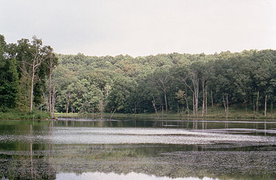
Through careful management, most of the natural plants and animals were restored. Native trees have replaced much of the brush and briers, and a canoe trip down the Mingo River will now reveal little to the casual observer of the abuses to this land in years past. Deer, wild turkey, bobcat and beaver have returned and are plentiful. The refuge is now able to accomplish its primary objective; providing food and shelter for migratory waterfowl. The establishment of the Mingo Wilderness Area
in 1976 helps ensure this protection for future generations of Americans.
ran between the Ozark Mountains and Crowley's Ridge
. Then, approximately 18,000 years ago, the river shifted, slicing its way through Crowley's Ridge to join the Ohio River
further north. The abandoned river bed developed into a rich and fertile swamp
.
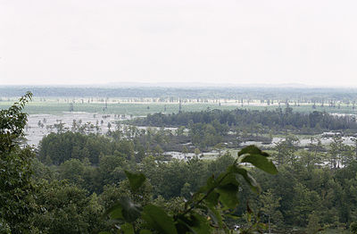
The Refuge lies in a basin formed in an ancient abandoned channel of the Mississippi River
, bordered on the west by the foothills of the Ozark Mountains, and on the east by a terrace called Crowley’s Ridge.
The refuge contains the only remaining large tract of bottomland forest of 15,000 acres (61 km2) from the original 2.5 million acres (10,000 km2) native to the bootheel of Missouri. There are seven natural areas and 99 archaeological sites.
Approximately 8000 acres (32 km2) of land are contained in the Mingo Wilderness
. Additionally, the 6,190 acre (25 km2) Missouri Department of Conservation, Duck Creek Conservation Area, http://mdc4.mdc.mo.gov/applications/moatlas/AreaSummaryPage.aspx?txtAreaID=5001, joins the refuge on the north and east boundary.
 Mingo's primary goal is to protect wilderness resources and critical habitat for migratory waterfowl. Located in the center of one of the busy Mississippi Flyway
, the refuge serves as an important resting and feeding area for migratory bird
s heading south.
In addition to resident waterfowl species, Mingo provides for migrating duck
s, geese, shorebirds, gull
s, tern
s, loon
s, grebe
s, pelican
s, cormorant
s, heron
s, bittern
s, ibis
es, rail
s, coot
s and swan
s. There are over 95 species of migratory waterfowl that have been seen at Mingo. Through year-round management of the water levels on the refuge, the feeding and resting requirements of migrating birds can be met. The refuge provides wintering habitat for over 150,000 ducks and 75,000 geese
Mingo also provides for other types of migratory and non-migratory avian species. Over 250 species of birds have been seen at Mingo. Included in this list are the peregrine falcon
, endangered whooping crane
and threatened bald eagle
.
In addition to migratory birds, Mingo provides year-round habitat for a variety of other species. Due to the diverse habitat, Mingo is home for a wide variety of lowland swamp species and upland forest and field species. Mingo is home to over 38 species of mammals, 23 species of amphibians and 37 species of reptiles. Due to wilderness protection and inaccessibility to many areas of the refuge, mammals, amphibians and reptiles are abundant but seldom seen, remaining for the most part unspoiled by man's influence.
Limited hunting for deer
, wild turkey
, squirrel
, and waterfowl
is available in designated areas of the refuge. Fishing for bass
, crappie
, bluegill
, and catfish
is a popular activity on the refuge.
 The refuge has three designated trails along with 50 miles (80.5 km) of unmarked trails:
bluffs
bordering the swamp that once was the mighty Mississippi River. This trail is rated "challenging" for hikers.
National Wildlife Refuge
National Wildlife Refuge is a designation for certain protected areas of the United States managed by the United States Fish and Wildlife Service. The National Wildlife Refuge System is the world's premiere system of public lands and waters set aside to conserve America's fish, wildlife and plants...
located in northwestern Stoddard
Stoddard County, Missouri
Stoddard County is a county located in Southeast Missouri in the United States. As of the 2000 U.S. Census, the population was 29,705. A 2008 estimate, however, showed the population to be 29,537. The county seat is Bloomfield while the largest city in the county is Dexter...
and southeastern Wayne
Wayne County, Missouri
Wayne County is a county located in the Ozark Foothills Region of Southeast Missouri in the United States. As of the 2000 U.S. Census, the population was 13,259. A 2008 estimate, however, showed the population to be 12,652. The county seat is Greenville...
counties in Missouri
Missouri
Missouri is a US state located in the Midwestern United States, bordered by Iowa, Illinois, Kentucky, Tennessee, Arkansas, Oklahoma, Kansas and Nebraska. With a 2010 population of 5,988,927, Missouri is the 18th most populous state in the nation and the fifth most populous in the Midwest. It...
. Its southwesternmost portion lies on the shores of Lake Wappapello
Lake Wappapello
Lake Wappapello is a reservoir on the St. Francis River, formed by Wappapello Dam . Created in 1941, this lake is located south of St. Louis, Missouri. Its primary purpose is flood control though it has evolved into a recreational area with ample opportunities to boat, fish, swim or camp. The...
. Named after the Mingo tribe
Mingo
The Mingo are an Iroquoian group of Native Americans made up of peoples who migrated west to the Ohio Country in the mid-eighteenth century. Anglo-Americans called these migrants mingos, a corruption of mingwe, an Eastern Algonquian name for Iroquoian-language groups in general. Mingos have also...
, it was established to preserve bottomland hardwoods as well as provide waterfowl and other migratory birds in the Mississippi Flyway
Mississippi Flyway
The Mississippi Flyway is a bird migration route that generally follows the Mississippi River in the United States and the Mackenzie River in Canada. The main endpoints of the flyway include central Canada and the region surrounding the Gulf of Mexico...
with nesting, feeding, brooding, and resting habitat.
The refuge is maintained with a nine person staff with a fiscal year 2004 budget of $1.2 million.
History
Louisiana Purchase
The Louisiana Purchase was the acquisition by the United States of America of of France's claim to the territory of Louisiana in 1803. The U.S...
. At that time, the population of the entire Bootheel
Bootheel
The Missouri Bootheel is the southeasternmost part of the state of Missouri, extending south of 36°30’ north latitude, so called because its shape in relation to the rest of the state resembles the heel of a boot. Strictly speaking, it is composed of the counties of Dunklin, New Madrid, and Pemiscot...
was sparse and the swamp area was considered inaccessible. When Missouri became a state in 1821, all of the counties in southeast Missouri had settlers, except Stoddard
Stoddard County, Missouri
Stoddard County is a county located in Southeast Missouri in the United States. As of the 2000 U.S. Census, the population was 29,705. A 2008 estimate, however, showed the population to be 29,537. The county seat is Bloomfield while the largest city in the county is Dexter...
and Dunklin
Dunklin County, Missouri
Dunklin County is a county located in the Bootheel of Southeast Missouri in the United States. As of the 2000 U.S. Census, the county's population was 33,155. A 2008 estimate, however, showed the population to be 31,454. The largest city and county seat is Kennett...
counties, although Cape Girardeau was one of the most important river towns in Missouri.
Settlers first came to the swamp because of the vast cypress
Cupressaceae
The Cupressaceae or cypress family is a conifer family with worldwide distribution. The family includes 27 to 30 genera , which include the junipers and redwoods, with about 130-140 species in total. They are monoecious, subdioecious or dioecious trees and shrubs from 1-116 m tall...
and tupelo
Tupelo
The tupelo , black gum, or pepperidge tree, genus Nyssa , is a small genus of about 9 to 11 species of trees with alternate, simple leaves...
forests. The giant cypress trees were the first to be used for railroad ties and building lumber. The T.J. Moss Tie Company was a large Bootheel lumbering operation, with its headquarters in Puxico, Missouri
Puxico, Missouri
Puxico is a city in Stoddard County, Missouri, United States. The population was 1,145 at the 2000 census.-Geography:Puxico is located at .According to the United States Census Bureau, the city has a total area of , all of it land....
. By 1888, T.J. Moss was the largest tie contractor in the state, and many of their ties were cut from trees taken from the swamp. A large mill was operated just north of Puxico on land now within Mingo NWR. Local sources claim that, at one time, the mill was the largest bandsaw mill in America. The lumber industry reached peak production in the Bootheel between 1900 and 1910. During its peak, the Bootheel was consistently the leading lumber-producing area of Missouri. However, by 1935 most of the large operations had ceased. The giant trees were cut and it was necessary to find lumber in other places.
The powerful and wealthy lumber companies had not lost interest in the Bootheel yet. If the land could be drained it would again become an important source of revenue. The size of the projects remained small because of the expanse involved. The lumber companies had considerable capital to invest, but demanded large grants of land for the drainage and were frequently more interested in the land than in efficiency of their drainage ditches. The Missiouri State Legislature
Missouri General Assembly
The Missouri General Assembly is the state legislature of the U.S. state of Missouri. The bicameral General Assembly is composed of a 34-member Senate, and a 163-member House of Representatives. Members of both houses of the General Assembly are subject to term limits...
passed an act that allowed the formation of drainage district
Drainage district
Drainage districts occur in England and Wales, varying in size from a few hundred acres to over , all in low lying areas of the country where flood risk management and land drainage are sensitive issues...
s, financed by long-term bonds. For the first time, drainage projects could be adequately financed and many drainage districts were created in the Bootheel.
In 1914, more than 20 drainage districts existed in Stoddard County. One of them was the Mingo Drainage District, a small district in the Advance Lowlands near Puxico. More than $1 million was spent to make Mingo Swamp suitable for farming. A system of seven major north-south ditches was constructed to drain water from the swamp into the St. Francis River
St. Francis River
The Saint Francis River is a tributary of the Mississippi River, about long, in southeastern Missouri and northeastern Arkansas in the United States...
, about 10 miles (16.1 km) south of Puxico. Except for the narrow southern extension of the district south of Puxico, the District's boundary and the Mingo NWR boundary are essentially the same. The ditches constructed by the district are used today by the refuge for water control and management.
During the Great Depression
Great Depression
The Great Depression was a severe worldwide economic depression in the decade preceding World War II. The timing of the Great Depression varied across nations, but in most countries it started in about 1929 and lasted until the late 1930s or early 1940s...
, land values plummeted and many of the large landholders (lumber companies) defaulted on payment of taxes rather than continue to maintain unprofitable investments in the land. Throughout the Bootheel, many drainage districts were unable to meet financial obligations and defaulted on bond payments, largely because they couldn't absorb the loss of revenue created by the large landholders. Mingo District was one of these.
Drainage attempts at Mingo had not been completely successful, at least in part because of the overflow from the St. Francis River. Also, the soil was not as productive as in other areas of the Bootheel. During the 1930s, Mingo District became insolvent.
The remaining timber was cut by anyone without regard to ownership. The area was open range country. Cattle and hogs ran over the entire swamp. To maintain it in a grassy condition, the land was burned, often several times a year. Hogs and cattle became so numerous that they overflowed into the small towns near the swamp.
Indiscriminate shooting of waterfowl was common. Other wildlife species were also not faring so well. Beaver and deer had disappeared and the wild turkey were nearly extinct from the swamp.
In 1945, the United States Fish and Wildlife Service
United States Fish and Wildlife Service
The United States Fish and Wildlife Service is a federal government agency within the United States Department of the Interior dedicated to the management of fish, wildlife, and natural habitats...
purchased 21,676 acres (87.7 km2) of the Mingo Swamp and established the Mingo NWR. The condition of the land was deplorable. In the previous 50 years, man had reduced a beautiful swamp, lush with the growth of plants and alive with animals, into a burnt and eroded wasteland.
Through careful management, most of the natural plants and animals were restored. Native trees have replaced much of the brush and briers, and a canoe trip down the Mingo River will now reveal little to the casual observer of the abuses to this land in years past. Deer, wild turkey, bobcat and beaver have returned and are plentiful. The refuge is now able to accomplish its primary objective; providing food and shelter for migratory waterfowl. The establishment of the Mingo Wilderness Area
Mingo Wilderness
Mingo Wilderness is an 8,000 acre U.S. Wilderness Area located in southeastern Missouri in the Mingo National Wildlife Refuge. It was established and governed under the Wilderness Act of 1964....
in 1976 helps ensure this protection for future generations of Americans.
Topography
Approximately, 25,000 years ago the Mississippi RiverMississippi River
The Mississippi River is the largest river system in North America. Flowing entirely in the United States, this river rises in western Minnesota and meanders slowly southwards for to the Mississippi River Delta at the Gulf of Mexico. With its many tributaries, the Mississippi's watershed drains...
ran between the Ozark Mountains and Crowley's Ridge
Crowley's Ridge
Crowley's Ridge is an unusual geological formation that rises 250 to above the alluvial plain of the Mississippi embayment in a line from southeastern Missouri to the Mississippi River near Helena, Arkansas. It is the most prominent feature in the Mississippi Alluvial Plain between Cape...
. Then, approximately 18,000 years ago, the river shifted, slicing its way through Crowley's Ridge to join the Ohio River
Ohio River
The Ohio River is the largest tributary, by volume, of the Mississippi River. At the confluence, the Ohio is even bigger than the Mississippi and, thus, is hydrologically the main stream of the whole river system, including the Allegheny River further upstream...
further north. The abandoned river bed developed into a rich and fertile swamp
Swamp
A swamp is a wetland with some flooding of large areas of land by shallow bodies of water. A swamp generally has a large number of hammocks, or dry-land protrusions, covered by aquatic vegetation, or vegetation that tolerates periodical inundation. The two main types of swamp are "true" or swamp...
.
The Refuge lies in a basin formed in an ancient abandoned channel of the Mississippi River
Mississippi River
The Mississippi River is the largest river system in North America. Flowing entirely in the United States, this river rises in western Minnesota and meanders slowly southwards for to the Mississippi River Delta at the Gulf of Mexico. With its many tributaries, the Mississippi's watershed drains...
, bordered on the west by the foothills of the Ozark Mountains, and on the east by a terrace called Crowley’s Ridge.
The refuge contains the only remaining large tract of bottomland forest of 15,000 acres (61 km2) from the original 2.5 million acres (10,000 km2) native to the bootheel of Missouri. There are seven natural areas and 99 archaeological sites.
Approximately 8000 acres (32 km2) of land are contained in the Mingo Wilderness
Mingo Wilderness
Mingo Wilderness is an 8,000 acre U.S. Wilderness Area located in southeastern Missouri in the Mingo National Wildlife Refuge. It was established and governed under the Wilderness Act of 1964....
. Additionally, the 6,190 acre (25 km2) Missouri Department of Conservation, Duck Creek Conservation Area, http://mdc4.mdc.mo.gov/applications/moatlas/AreaSummaryPage.aspx?txtAreaID=5001, joins the refuge on the north and east boundary.
Wildlife and protected species
Mississippi Flyway
The Mississippi Flyway is a bird migration route that generally follows the Mississippi River in the United States and the Mackenzie River in Canada. The main endpoints of the flyway include central Canada and the region surrounding the Gulf of Mexico...
, the refuge serves as an important resting and feeding area for migratory bird
Bird migration
Bird migration is the regular seasonal journey undertaken by many species of birds. Bird movements include those made in response to changes in food availability, habitat or weather. Sometimes, journeys are not termed "true migration" because they are irregular or in only one direction...
s heading south.
In addition to resident waterfowl species, Mingo provides for migrating duck
Duck
Duck is the common name for a large number of species in the Anatidae family of birds, which also includes swans and geese. The ducks are divided among several subfamilies in the Anatidae family; they do not represent a monophyletic group but a form taxon, since swans and geese are not considered...
s, geese, shorebirds, gull
Gull
Gulls are birds in the family Laridae. They are most closely related to the terns and only distantly related to auks, skimmers, and more distantly to the waders...
s, tern
Tern
Terns are seabirds in the family Sternidae, previously considered a subfamily of the gull family Laridae . They form a lineage with the gulls and skimmers which in turn is related to skuas and auks...
s, loon
Loon
The loons or divers are a group of aquatic birds found in many parts of North America and northern Eurasia...
s, grebe
Grebe
A grebe is a member of the Podicipediformes order, a widely distributed order of freshwater diving birds, some of which visit the sea when migrating and in winter...
s, pelican
Pelican
A pelican, derived from the Greek word πελεκυς pelekys is a large water bird with a large throat pouch, belonging to the bird family Pelecanidae....
s, cormorant
Cormorant
The bird family Phalacrocoracidae is represented by some 40 species of cormorants and shags. Several different classifications of the family have been proposed recently, and the number of genera is disputed.- Names :...
s, heron
Heron
The herons are long-legged freshwater and coastal birds in the family Ardeidae. There are 64 recognised species in this family. Some are called "egrets" or "bitterns" instead of "heron"....
s, bittern
Bittern
Bitterns are a classification of birds in the heron family, Ardeidae, a family of wading birds. Species named bitterns tend to be the shorter-necked, often more secretive members of this family...
s, ibis
Ibis
The ibises are a group of long-legged wading birds in the family Threskiornithidae....
es, rail
Rallidae
The rails, or Rallidae, are a large cosmopolitan family of small to medium-sized birds. The family exhibits considerable diversity and the family also includes the crakes, coots, and gallinules...
s, coot
Coot
Coots are medium-sized water birds that are members of the rail family Rallidae. They constitute the genus Fulica. Coots have predominantly black plumage, and, unlike many of the rails, they are usually easy to see, often swimming in open water...
s and swan
Swan
Swans, genus Cygnus, are birds of the family Anatidae, which also includes geese and ducks. Swans are grouped with the closely related geese in the subfamily Anserinae where they form the tribe Cygnini. Sometimes, they are considered a distinct subfamily, Cygninae...
s. There are over 95 species of migratory waterfowl that have been seen at Mingo. Through year-round management of the water levels on the refuge, the feeding and resting requirements of migrating birds can be met. The refuge provides wintering habitat for over 150,000 ducks and 75,000 geese
Mingo also provides for other types of migratory and non-migratory avian species. Over 250 species of birds have been seen at Mingo. Included in this list are the peregrine falcon
Peregrine Falcon
The Peregrine Falcon , also known as the Peregrine, and historically as the Duck Hawk in North America, is a widespread bird of prey in the family Falconidae. A large, crow-sized falcon, it has a blue-gray back, barred white underparts, and a black head and "moustache"...
, endangered whooping crane
Whooping Crane
The whooping crane , the tallest North American bird, is an endangered crane species named for its whooping sound. Along with the Sandhill Crane, it is one of only two crane species found in North America. The whooping crane's lifespan is estimated to be 22 to 24 years in the wild...
and threatened bald eagle
Bald Eagle
The Bald Eagle is a bird of prey found in North America. It is the national bird and symbol of the United States of America. This sea eagle has two known sub-species and forms a species pair with the White-tailed Eagle...
.
In addition to migratory birds, Mingo provides year-round habitat for a variety of other species. Due to the diverse habitat, Mingo is home for a wide variety of lowland swamp species and upland forest and field species. Mingo is home to over 38 species of mammals, 23 species of amphibians and 37 species of reptiles. Due to wilderness protection and inaccessibility to many areas of the refuge, mammals, amphibians and reptiles are abundant but seldom seen, remaining for the most part unspoiled by man's influence.
Facilities
Wildlife Observation and Photography are welcomed at the refuge. Twelve miles of refuge roadway are open daily, providing four observation overlooks and one boardwalk nature trail. A twenty-five-mile, scenic, seasonal auto tour route is open throughout April and May to view spring wildflowers and spring songbird migration and October and November for the fall foliage and waterfowl migration.Limited hunting for deer
Deer
Deer are the ruminant mammals forming the family Cervidae. Species in the Cervidae family include white-tailed deer, elk, moose, red deer, reindeer, fallow deer, roe deer and chital. Male deer of all species and female reindeer grow and shed new antlers each year...
, wild turkey
Wild Turkey
The Wild Turkey is native to North America and is the heaviest member of the Galliformes. It is the same species as the domestic turkey, which derives from the South Mexican subspecies of wild turkey .Adult wild turkeys have long reddish-yellow to grayish-green...
, squirrel
Squirrel
Squirrels belong to a large family of small or medium-sized rodents called the Sciuridae. The family includes tree squirrels, ground squirrels, chipmunks, marmots , flying squirrels, and prairie dogs. Squirrels are indigenous to the Americas, Eurasia, and Africa and have been introduced to Australia...
, and waterfowl
Waterfowl
Waterfowl are certain wildfowl of the order Anseriformes, especially members of the family Anatidae, which includes ducks, geese, and swans....
is available in designated areas of the refuge. Fishing for bass
Bass (fish)
Bass is a name shared by many different species of popular gamefish. The term encompasses both freshwater and marine species. All belong to the large order Perciformes, or perch-like fishes, and in fact the word bass comes from Middle English bars, meaning "perch."-Types of basses:*The temperate...
, crappie
Crappie
Crappie is a genus of freshwater fish in the sunfish family of order Perciformes. The type species is P. annularis, the white crappie...
, bluegill
Bluegill
The Bluegill is a species of freshwater fish sometimes referred to as bream, brim, or copper nose. It is a member of the sunfish family Centrarchidae of the order Perciformes.-Range and distribution:...
, and catfish
Catfish
Catfishes are a diverse group of ray-finned fish. Named for their prominent barbels, which resemble a cat's whiskers, catfish range in size and behavior from the heaviest and longest, the Mekong giant catfish from Southeast Asia and the second longest, the wels catfish of Eurasia, to detritivores...
is a popular activity on the refuge.
Trails
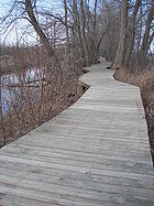
Boardwalk Nature Trail
The Boardwalk Nature Trail allows visitors to enjoy the beauty of Mingo swamp without getting wet. Down this path lies a one mile (1.6 km) loop trail through the bottomland hardwood swamp. A self-guided pamphlet of the trail is available at the Boardwalk parking lot. The path is wheelchair accessible.Bluff Trail
The 1/4 mile Bluff Trail begins at the Visitor Center and connects with the Boardwalk. It provides a fascinating hike when wildflowers are blooming in the spring. It also furnishes an interesting view of the steep limestoneLimestone
Limestone is a sedimentary rock composed largely of the minerals calcite and aragonite, which are different crystal forms of calcium carbonate . Many limestones are composed from skeletal fragments of marine organisms such as coral or foraminifera....
bluffs
Hill
A hill is a landform that extends above the surrounding terrain. Hills often have a distinct summit, although in areas with scarp/dip topography a hill may refer to a particular section of flat terrain without a massive summit A hill is a landform that extends above the surrounding terrain. Hills...
bordering the swamp that once was the mighty Mississippi River. This trail is rated "challenging" for hikers.