

List of U.S. states by time zone
Encyclopedia
Time zone
A time zone is a region on Earth that has a uniform standard time for legal, commercial, and social purposes. In order for the same clock time to always correspond to the same portion of the day as the Earth rotates , different places on the Earth need to have different clock times...
s by U.S. state
U.S. state
A U.S. state is any one of the 50 federated states of the United States of America that share sovereignty with the federal government. Because of this shared sovereignty, an American is a citizen both of the federal entity and of his or her state of domicile. Four states use the official title of...
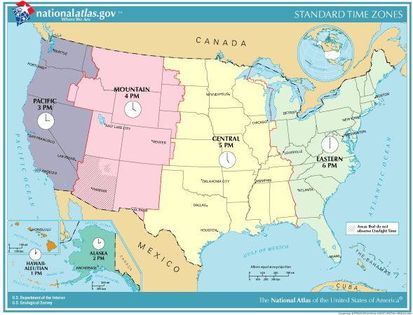
s. For more about the time zones of the U.S. see time in the United States
Time in the United States
Time in the United States, by law, is divided into nine standard time zones covering the states and its possessions, with most of the United States observing daylight saving time for part of the year....
.
Most states are entirely contained within one time zone. However, some states are in two time zones, due to geographical, socio-political or economic reasons.
States, territories, etc.
| State |
Time Zone |
DST |
Details |
|---|---|---|---|
| Alabama Alabama Alabama is a state located in the southeastern region of the United States. It is bordered by Tennessee to the north, Georgia to the east, Florida and the Gulf of Mexico to the south, and Mississippi to the west. Alabama ranks 30th in total land area and ranks second in the size of its inland... |
UTC−05:00 ET UTC−06:00 CT |
DST |
|
| Alaska Alaska Alaska is the largest state in the United States by area. It is situated in the northwest extremity of the North American continent, with Canada to the east, the Arctic Ocean to the north, and the Pacific Ocean to the west and south, with Russia further west across the Bering Strait... |
UTC−09:00 UTC−10:00 |
DST |
|
| American Samoa American Samoa American Samoa is an unincorporated territory of the United States located in the South Pacific Ocean, southeast of the sovereign state of Samoa... |
UTC−11:00 | No | Samoa Standard Time Samoa Time Zone thumb|right|250px|SST is [[UTC-11]]The Samoa Time Zone observes standard time by subtracting eleven hours from Coordinated Universal Time . The clock time in this zone is based on the mean solar time of the 165th meridian west west of the Greenwich Observatory.The zone includes the U.S... |
| Arizona Arizona Arizona ; is a state located in the southwestern region of the United States. It is also part of the western United States and the mountain west. The capital and largest city is Phoenix... |
UTC−07:00 MT | Part | Mountain. Except for the Navajo Nation Navajo Nation The Navajo Nation is a semi-autonomous Native American-governed territory covering , occupying all of northeastern Arizona, the southeastern portion of Utah, and northwestern New Mexico... , Arizona does not observe DST. |
| Arkansas Arkansas Arkansas is a state located in the southern region of the United States. Its name is an Algonquian name of the Quapaw Indians. Arkansas shares borders with six states , and its eastern border is largely defined by the Mississippi River... |
UTC−06:00 CT | DST | Central |
| California California California is a state located on the West Coast of the United States. It is by far the most populous U.S. state, and the third-largest by land area... |
UTC−08:00 PT | DST | Pacific |
| Colorado Colorado Colorado is a U.S. state that encompasses much of the Rocky Mountains as well as the northeastern portion of the Colorado Plateau and the western edge of the Great Plains... |
UTC−07:00 MT | DST | Mountain |
| Connecticut Connecticut Connecticut is a state in the New England region of the northeastern United States. It is bordered by Rhode Island to the east, Massachusetts to the north, and the state of New York to the west and the south .Connecticut is named for the Connecticut River, the major U.S. river that approximately... |
UTC−05:00 ET | DST | Eastern |
| Delaware Delaware Delaware is a U.S. state located on the Atlantic Coast in the Mid-Atlantic region of the United States. It is bordered to the south and west by Maryland, and to the north by Pennsylvania... |
UTC−05:00 ET | DST | Eastern |
| Florida Florida Florida is a state in the southeastern United States, located on the nation's Atlantic and Gulf coasts. It is bordered to the west by the Gulf of Mexico, to the north by Alabama and Georgia and to the east by the Atlantic Ocean. With a population of 18,801,310 as measured by the 2010 census, it... |
UTC−05:00 ET UTC−06:00 CT |
DST |
Florida Panhandle The Florida Panhandle, an informal, unofficial term for the northwestern part of Florida, is a strip of land roughly 200 miles long and 50 to 100 miles wide , lying between Alabama on the north and the west, Georgia also on the north, and the Gulf of Mexico to the south. Its eastern boundary is... West of the Apalachicola River Apalachicola River The Apalachicola River is a river, approximately 112 mi long in the State of Florida. This river's large watershed, known as the ACF River Basin for short, drains an area of approximately into the Gulf of Mexico. The distance to its farthest headstream in northeast Georgia is approximately 500... , except the portions of Franklin Franklin County, Florida Franklin County is a coastal county located in the panhandle of the U.S. state of Florida. As of 2000, the population was 11,057. The U.S. Census Bureau 2005 estimate for the county is 11,177... and Gulf Gulf County, Florida Gulf County is a county located in the panhandle of the U.S. state of Florida. As of 2000, the population was 13,332. The U.S. Census Bureau 2005 estimate for the county is 13,975 . Its county seat is Port St. Joe.- History :... Counties lying south of the Intracoastal Waterway Intracoastal Waterway The Intracoastal Waterway is a 3,000-mile waterway along the Atlantic and Gulf coasts of the United States. Some lengths consist of natural inlets, salt-water rivers, bays, and sounds; others are artificial canals... : UTC−06:00 CST Central Standard Time |
| Georgia Georgia (U.S. state) Georgia is a state located in the southeastern United States. It was established in 1732, the last of the original Thirteen Colonies. The state is named after King George II of Great Britain. Georgia was the fourth state to ratify the United States Constitution, on January 2, 1788... |
UTC−05:00 ET | DST | Eastern |
| Guam Guam Guam is an organized, unincorporated territory of the United States located in the western Pacific Ocean. It is one of five U.S. territories with an established civilian government. Guam is listed as one of 16 Non-Self-Governing Territories by the Special Committee on Decolonization of the United... |
UTC+10:00 | No | Chamorro Standard Time |
| Hawaii Hawaii Hawaii is the newest of the 50 U.S. states , and is the only U.S. state made up entirely of islands. It is the northernmost island group in Polynesia, occupying most of an archipelago in the central Pacific Ocean, southwest of the continental United States, southeast of Japan, and northeast of... |
UTC−10:00 | No | Hawaiian |
| Idaho Idaho Idaho is a state in the Rocky Mountain area of the United States. The state's largest city and capital is Boise. Residents are called "Idahoans". Idaho was admitted to the Union on July 3, 1890, as the 43rd state.... |
UTC−07:00 MT UTC−08:00 PT |
DST |
|
| Illinois Illinois Illinois is the fifth-most populous state of the United States of America, and is often noted for being a microcosm of the entire country. With Chicago in the northeast, small industrial cities and great agricultural productivity in central and northern Illinois, and natural resources like coal,... |
UTC−06:00 CT | DST | Central |
| Indiana Indiana Indiana is a US state, admitted to the United States as the 19th on December 11, 1816. It is located in the Midwestern United States and Great Lakes Region. With 6,483,802 residents, the state is ranked 15th in population and 16th in population density. Indiana is ranked 38th in land area and is... |
UTC−05:00 ET UTC−06:00 CT |
DST |
Time in Indiana Time in Indiana refers to the controversial time zone division of Indiana, and to the state's historical response to daylight saving time. The official dividing line between Eastern Time and Central Time has, over time, progressively moved west, from the Indiana–Ohio border, to a position where it... for more information |
| Iowa Iowa Iowa is a state located in the Midwestern United States, an area often referred to as the "American Heartland". It derives its name from the Ioway people, one of the many American Indian tribes that occupied the state at the time of European exploration. Iowa was a part of the French colony of New... |
UTC−06:00 CT | DST | Central |
| Kansas Kansas Kansas is a US state located in the Midwestern United States. It is named after the Kansas River which flows through it, which in turn was named after the Kansa Native American tribe, which inhabited the area. The tribe's name is often said to mean "people of the wind" or "people of the south... |
UTC−06:00 CT UTC−07:00 MT |
DST |
Greeley County, Kansas Greeley County is a county located in West Central Kansas, in the Central United States. As of the 2010 census, the county population was 1,247, which is the lowest in Kansas. Its county seat and largest town is Tribune... , Hamilton Hamilton County, Kansas Hamilton County is a county located in Southwest Kansas, in the Central United States. As of the 2010 census, the county population was 2,690... , Sherman Sherman County, Kansas Sherman County is a county located in the U.S. state of Kansas. As of the 2010 census, the county population was 6,010... and Wallace Wallace County, Kansas Wallace County is a county located in the U.S. state of Kansas. As of the 2010 census, the county population was 1,485. It has the second lowest population of any county in Kansas. Greeley County has the lowest. Its county seat is Sharon Springs. It was created in 1868 and named in honor of... counties: UTC−07:00 MST Mountain Standard Time |
| Kentucky Kentucky The Commonwealth of Kentucky is a state located in the East Central United States of America. As classified by the United States Census Bureau, Kentucky is a Southern state, more specifically in the East South Central region. Kentucky is one of four U.S. states constituted as a commonwealth... |
UTC−05:00 ET UTC−06:00 CT |
DST |
|
| Louisiana Louisiana Louisiana is a state located in the southern region of the United States of America. Its capital is Baton Rouge and largest city is New Orleans. Louisiana is the only state in the U.S. with political subdivisions termed parishes, which are local governments equivalent to counties... |
UTC−06:00 CT | DST | Central |
| Maine Maine Maine is a state in the New England region of the northeastern United States, bordered by the Atlantic Ocean to the east and south, New Hampshire to the west, and the Canadian provinces of Quebec to the northwest and New Brunswick to the northeast. Maine is both the northernmost and easternmost... |
UTC−05:00 ET | DST | Eastern |
| Maryland Maryland Maryland is a U.S. state located in the Mid Atlantic region of the United States, bordering Virginia, West Virginia, and the District of Columbia to its south and west; Pennsylvania to its north; and Delaware to its east... |
UTC−05:00 ET | DST | Eastern |
| Massachusetts Massachusetts The Commonwealth of Massachusetts is a state in the New England region of the northeastern United States of America. It is bordered by Rhode Island and Connecticut to the south, New York to the west, and Vermont and New Hampshire to the north; at its east lies the Atlantic Ocean. As of the 2010... |
UTC−05:00 ET | DST | Eastern |
| Michigan Michigan Michigan is a U.S. state located in the Great Lakes Region of the United States of America. The name Michigan is the French form of the Ojibwa word mishigamaa, meaning "large water" or "large lake".... |
UTC−05:00 ET UTC−06:00 CT |
DST |
Wisconsin Wisconsin is a U.S. state located in the north-central United States and is part of the Midwest. It is bordered by Minnesota to the west, Iowa to the southwest, Illinois to the south, Lake Michigan to the east, Michigan to the northeast, and Lake Superior to the north. Wisconsin's capital is... : UTC−06:00 CST Central Standard Time |
| Minnesota Minnesota Minnesota is a U.S. state located in the Midwestern United States. The twelfth largest state of the U.S., it is the twenty-first most populous, with 5.3 million residents. Minnesota was carved out of the eastern half of the Minnesota Territory and admitted to the Union as the thirty-second state... |
UTC−06:00 CT | DST | Central |
| Mississippi Mississippi Mississippi is a U.S. state located in the Southern United States. Jackson is the state capital and largest city. The name of the state derives from the Mississippi River, which flows along its western boundary, whose name comes from the Ojibwe word misi-ziibi... |
UTC−06:00 CT | DST | Central |
| Missouri Missouri Missouri is a US state located in the Midwestern United States, bordered by Iowa, Illinois, Kentucky, Tennessee, Arkansas, Oklahoma, Kansas and Nebraska. With a 2010 population of 5,988,927, Missouri is the 18th most populous state in the nation and the fifth most populous in the Midwest. It... |
UTC−06:00 CT | DST | Central |
| Montana Montana Montana is a state in the Western United States. The western third of Montana contains numerous mountain ranges. Smaller, "island ranges" are found in the central third of the state, for a total of 77 named ranges of the Rocky Mountains. This geographical fact is reflected in the state's name,... |
UTC−07:00 MT | DST | Mountain |
| Nebraska Nebraska Nebraska is a state on the Great Plains of the Midwestern United States. The state's capital is Lincoln and its largest city is Omaha, on the Missouri River.... |
UTC−06:00 CT UTC−07:00 MT |
DST |
Nebraska Panhandle The Nebraska Panhandle is an area in the west of the state of Nebraska. A panhandle is an area extending from the rest of a political unit; the Nebraska panhandle is two-thirds as broad as the rest of the state. It is approximately 100 miles east to west and 125 miles north to south... , counties with Colorado Colorado Colorado is a U.S. state that encompasses much of the Rocky Mountains as well as the northeastern portion of the Colorado Plateau and the western edge of the Great Plains... as a western boundary, and the western Sand Hills Sand Hills (Nebraska) The Sand Hills, often written Sandhills, is a region of mixed-grass prairie on grass-stabilized sand dunes in north-central Nebraska, covering just over one quarter of the state... : UTC−07:00 MST Mountain Standard Time |
| Nevada Nevada Nevada is a state in the western, mountain west, and southwestern regions of the United States. With an area of and a population of about 2.7 million, it is the 7th-largest and 35th-most populous state. Over two-thirds of Nevada's people live in the Las Vegas metropolitan area, which contains its... |
UTC−07:00 MT UTC−08:00 PT |
DST |
Jackpot, Nevada Jackpot is an unincorporated community in Elko County, Nevada, United States. The Zip Code Tabulation Area for its ZIP code, 89825, had a population of 1,189 as of the 2010 census. Located less than 1 mile from the Idaho border on U.S... and West Wendover West Wendover, Nevada West Wendover is a city in Elko County, Nevada, United States. The population was 4,721 at the 2000 census. It is part of the Elko Micropolitan Statistical Area. West Wendover is located on the eastern border of Nevada and the western edge of the Great Salt Lake Desert, and is contiguous with... : UTC−07:00 MST Mountain Standard Time |
| New Hampshire New Hampshire New Hampshire is a state in the New England region of the northeastern United States of America. The state was named after the southern English county of Hampshire. It is bordered by Massachusetts to the south, Vermont to the west, Maine and the Atlantic Ocean to the east, and the Canadian... |
UTC−05:00 ET | DST | Eastern |
| New Jersey New Jersey New Jersey is a state in the Northeastern and Middle Atlantic regions of the United States. , its population was 8,791,894. It is bordered on the north and east by the state of New York, on the southeast and south by the Atlantic Ocean, on the west by Pennsylvania and on the southwest by Delaware... |
UTC−05:00 ET | DST | Eastern |
| New Mexico New Mexico New Mexico is a state located in the southwest and western regions of the United States. New Mexico is also usually considered one of the Mountain States. With a population density of 16 per square mile, New Mexico is the sixth-most sparsely inhabited U.S... |
UTC−07:00 MT | DST | Mountain |
| New York New York New York is a state in the Northeastern region of the United States. It is the nation's third most populous state. New York is bordered by New Jersey and Pennsylvania to the south, and by Connecticut, Massachusetts and Vermont to the east... |
UTC−05:00 ET | DST | Eastern |
| North Carolina North Carolina North Carolina is a state located in the southeastern United States. The state borders South Carolina and Georgia to the south, Tennessee to the west and Virginia to the north. North Carolina contains 100 counties. Its capital is Raleigh, and its largest city is Charlotte... |
UTC−05:00 ET | DST | Eastern |
| North Dakota North Dakota North Dakota is a state located in the Midwestern region of the United States of America, along the Canadian border. The state is bordered by Canada to the north, Minnesota to the east, South Dakota to the south and Montana to the west. North Dakota is the 19th-largest state by area in the U.S.... |
UTC−06:00 CT UTC−07:00 MT |
DST |
Missouri River The Missouri River flows through the central United States, and is a tributary of the Mississippi River. It is the longest river in North America and drains the third largest area, though only the thirteenth largest by discharge. The Missouri's watershed encompasses most of the American Great... (except Morton Morton County, North Dakota -Demographics:As of the census of 2000, there were 25,303 people, 9,889 households, and 6,932 families residing in the county. The population density was 13 people per square mile . There were 10,587 housing units at an average density of 6 per square mile... and Oliver Oliver County, North Dakota -Demographics:As of the census of 2000, there were 2,065 people, 791 households, and 604 families residing in the county. The population density was 1/km² . There were 903 housing units at an average density of 0/km²... counties, and parts of Dunn Dunn County, North Dakota -Major highways:*North Dakota Highway 8*North Dakota Highway 22*North Dakota Highway 200-Demographics:As of the census of 2000, there were 3,600 people, 1,378 households, and 986 families residing in the county. The population density was 2 people per square mile . There were 1,965 housing units... , McKenzie McKenzie County, North Dakota -Major highways:* U.S. Highway 85* North Dakota Highway 22* North Dakota Highway 23* North Dakota Highway 58* North Dakota Highway 68* North Dakota Highway 73* North Dakota Highway 200* North Dakota Highway 1806-National protected areas:... , and Sioux Sioux County, North Dakota -Demographics:As of the census of 2000, there were 4,044 people, 1,095 households, and 871 families residing in the county. The population density was 4 people per square mile . There were 1,216 housing units at an average density of 1 per square mile... counties: UTC−07:00 MST Mountain Standard Time |
| Northern Mariana Islands | UTC+10:00 | No | Chamorro Standard Time |
| Ohio Ohio Ohio is a Midwestern state in the United States. The 34th largest state by area in the U.S.,it is the 7th‑most populous with over 11.5 million residents, containing several major American cities and seven metropolitan areas with populations of 500,000 or more.The state's capital is Columbus... |
UTC−05:00 ET | DST | Eastern |
| Oklahoma Oklahoma Oklahoma is a state located in the South Central region of the United States of America. With an estimated 3,751,351 residents as of the 2010 census and a land area of 68,667 square miles , Oklahoma is the 28th most populous and 20th-largest state... |
UTC−06:00 CT | DST | Central |
| Oregon Oregon Oregon is a state in the Pacific Northwest region of the United States. It is located on the Pacific coast, with Washington to the north, California to the south, Nevada on the southeast and Idaho to the east. The Columbia and Snake rivers delineate much of Oregon's northern and eastern... |
UTC−07:00 MT UTC−08:00 PT |
DST |
Malheur County, Oregon Malheur County is a county located in the southeast corner of the U.S. state of Oregon. It is included in the eight-county definition of Eastern Oregon. Most of the county observes the Mountain Time Zone, although the southern quarter of the county observes the Pacific Time Zone along with the... ): UTC−07:00 MST Mountain Standard Time |
| Pennsylvania Pennsylvania The Commonwealth of Pennsylvania is a U.S. state that is located in the Northeastern and Mid-Atlantic regions of the United States. The state borders Delaware and Maryland to the south, West Virginia to the southwest, Ohio to the west, New York and Ontario, Canada, to the north, and New Jersey to... |
UTC−05:00 ET | DST | Eastern |
| Puerto Rico Puerto Rico Puerto Rico , officially the Commonwealth of Puerto Rico , is an unincorporated territory of the United States, located in the northeastern Caribbean, east of the Dominican Republic and west of both the United States Virgin Islands and the British Virgin Islands.Puerto Rico comprises an... |
UTC−04:00 | No | Atlantic Standard Time Zone Atlantic Standard Time Zone The Atlantic Standard Time Zone is a geographical region that keeps time by subtracting four hours from either Coordinated Universal Time or Greenwich Mean Time , resulting in UTC-4 or GMT-4... |
| Rhode Island Rhode Island The state of Rhode Island and Providence Plantations, more commonly referred to as Rhode Island , is a state in the New England region of the United States. It is the smallest U.S. state by area... |
UTC−05:00 ET | DST | Eastern |
| South Carolina South Carolina South Carolina is a state in the Deep South of the United States that borders Georgia to the south, North Carolina to the north, and the Atlantic Ocean to the east. Originally part of the Province of Carolina, the Province of South Carolina was one of the 13 colonies that declared independence... |
UTC−05:00 ET | DST | Eastern |
| South Dakota South Dakota South Dakota is a state located in the Midwestern region of the United States. It is named after the Lakota and Dakota Sioux American Indian tribes. Once a part of Dakota Territory, South Dakota became a state on November 2, 1889. The state has an area of and an estimated population of just over... |
UTC−06:00 CT UTC−07:00 MT |
DST |
|
| Tennessee Tennessee Tennessee is a U.S. state located in the Southeastern United States. It has a population of 6,346,105, making it the nation's 17th-largest state by population, and covers , making it the 36th-largest by total land area... |
UTC−05:00 ET UTC−06:00 CT |
DST |
East Tennessee East Tennessee is a name given to approximately the eastern third of the U.S. state of Tennessee, one of the three Grand Divisions of Tennessee defined in state law. East Tennessee consists of 33 counties, 30 located within the Eastern Time Zone and three counties in the Central Time Zone, namely... , except Marion County Marion County, Tennessee Marion County is a county located in the U.S. state of Tennessee. As of 2000, the population was 27,776. Its county seat is Jasper.Marion County is part of the Chattanooga, TN–GA Metropolitan Statistical Area.-Geography:According to the U.S... : UTC−05:00 EST Eastern Standard Time |
| Texas Texas Texas is the second largest U.S. state by both area and population, and the largest state by area in the contiguous United States.The name, based on the Caddo word "Tejas" meaning "friends" or "allies", was applied by the Spanish to the Caddo themselves and to the region of their settlement in... |
UTC−06:00 CT UTC−07:00 MT |
DST |
Hudspeth County, Texas Hudspeth County is a county located in the U.S. state of Texas. It is one of the nine counties that comprise the Trans-Pecos region of West Texas. As of 2000, the population was 3,344. By 2010, the population had increased to 3,476. Its county seat is Sierra Blanca. The largest city is Fort Hancock... counties, and part of Culberson County Culberson County, Texas Culberson County is a county located in the U.S. state of Texas. It is one of the nine counties that comprise the Trans-Pecos region of West Texas. In 2000, its population was 2,975. Culberson was founded in 1911. It is named for David B. Culberson, a lawyer and Confederate soldier in the American... : UTC−07:00 MST Mountain Standard Time |
| Utah Utah Utah is a state in the Western United States. It was the 45th state to join the Union, on January 4, 1896. Approximately 80% of Utah's 2,763,885 people live along the Wasatch Front, centering on Salt Lake City. This leaves vast expanses of the state nearly uninhabited, making the population the... |
UTC−07:00 MT | DST | Mountain |
| Vermont Vermont Vermont is a state in the New England region of the northeastern United States of America. The state ranks 43rd in land area, , and 45th in total area. Its population according to the 2010 census, 630,337, is the second smallest in the country, larger only than Wyoming. It is the only New England... |
UTC−05:00 ET | DST | Eastern |
| Virginia Virginia The Commonwealth of Virginia , is a U.S. state on the Atlantic Coast of the Southern United States. Virginia is nicknamed the "Old Dominion" and sometimes the "Mother of Presidents" after the eight U.S. presidents born there... |
UTC−05:00 ET | DST | Eastern |
| U.S. Virgin Islands | UTC−04:00 | No | Atlantic |
| Washington | UTC−08:00 PT | DST | Pacific |
| Washington, D.C. Washington, D.C. Washington, D.C., formally the District of Columbia and commonly referred to as Washington, "the District", or simply D.C., is the capital of the United States. On July 16, 1790, the United States Congress approved the creation of a permanent national capital as permitted by the U.S. Constitution.... |
UTC−05:00 ET | DST | Eastern |
| West Virginia West Virginia West Virginia is a state in the Appalachian and Southeastern regions of the United States, bordered by Virginia to the southeast, Kentucky to the southwest, Ohio to the northwest, Pennsylvania to the northeast and Maryland to the east... |
UTC−05:00 ET | DST | Eastern |
| Wisconsin Wisconsin Wisconsin is a U.S. state located in the north-central United States and is part of the Midwest. It is bordered by Minnesota to the west, Iowa to the southwest, Illinois to the south, Lake Michigan to the east, Michigan to the northeast, and Lake Superior to the north. Wisconsin's capital is... |
UTC−06:00 CT | DST | Central |
| Wyoming Wyoming Wyoming is a state in the mountain region of the Western United States. The western two thirds of the state is covered mostly with the mountain ranges and rangelands in the foothills of the Eastern Rocky Mountains, while the eastern third of the state is high elevation prairie known as the High... |
UTC−07:00 MT | DST | Mountain |
See also
- History of time in the United States
- List of time zones
- Time in the United StatesTime in the United StatesTime in the United States, by law, is divided into nine standard time zones covering the states and its possessions, with most of the United States observing daylight saving time for part of the year....
External links
- The Official U.S. Time in each time zone
- North American Time Zone border data and images
- NIST Internet Time Service
- US time zones differences
- USNO NTP Network Time Servers
- U.S. Standard Time Zone map
- U.S. cities and towns shown in their respective time zones at Internet Accuracy Project
- Lookup US timezone offset by latitude, longitude and datetime - web service