

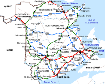
List of New Brunswick provincial highways
Encyclopedia
State highway
State highway, state road or state route can refer to one of three related concepts, two of them related to a state or provincial government in a country that is divided into states or provinces :#A...
s in the Canadian province of New Brunswick
New Brunswick
New Brunswick is one of Canada's three Maritime provinces and is the only province in the federation that is constitutionally bilingual . The provincial capital is Fredericton and Saint John is the most populous city. Greater Moncton is the largest Census Metropolitan Area...
. For a list of formerly-numbered highways, see List of former New Brunswick provincial highways.
Arterial Highways
Marked by green signs, these highways are the primary routes in the system, and Routes 1, 2, 7, 8, 11, 15, 16 and 95 are all expressways or freeways for part or all of their length. The speed limit generally ranges from 80 km/h (49.7 mph) to 110 km/h (68.4 mph) , with the highest limits on 4-lane freeway sections.| Route | Length (km) |
Length (mi) |
Southern / western terminus | Northern / eastern terminus | References |
|---|---|---|---|---|---|
| 237 | 147.3 | International Avenue to US 1 U.S. Route 1 in Maine In the U.S. state of Maine, U.S. Route 1 is a major north–south state highway serving the eastern part of the state. It parallels the Atlantic Ocean from New Hampshire north through Portland, Brunswick, and Belfast to Calais, and then the St. Croix River and the rest of the Canadian border... in Calais Calais, Maine Calais is a city in Washington County, Maine, United States. The city has three United States border crossings or also known as a Port of entry with the busiest being on the St. Croix River bordering St. Stephen, New Brunswick, Canada... |
Route 2 (TCH) New Brunswick Route 2 Route 2 is a major provincial highway in the Canadian province of New Brunswick, carrying the main route of the Trans-Canada Highway in the province... in River Glade River Glade, New Brunswick River Glade is a Canadian rural community in Westmorland County, New Brunswick.... |
||
| 514 | 319.4 | Route 185 (TCH) Quebec route 185 Route 185 is part of the Trans-Canada Highway. It travels from Saint-Antonin, Quebec to Edmundston, New Brunswick, a distance of about . It connects Autoroute 85 and New Brunswick Route 2.... near Edmundston Edmundston, New Brunswick Edmundston is a Canadian city in Madawaska County, New Brunswick.-History:During the early colonial period, the area was an important meeting place and hunting/fishing spot of the Maliseet nation. A considerable sized village was located there around the turn of the 19th century... |
Highway 104 (TCH) Nova Scotia Highway 104 Highway 104 in Nova Scotia runs from the New Brunswick border near Amherst to St. Peter's. Except for the portion on Cape Breton Island between Port Hawkesbury and St. Peter's, it is part of the Trans-Canada Highway.... near Fort Lawrence Fort Lawrence, Nova Scotia Fort Lawrence is a Canadian rural community located on the Isthmus of Chignecto in Cumberland County, Nova Scotia.Situated 1 km east of the Missaguash River which forms the inter-provincial boundary with New Brunswick, Fort Lawrence is situated on a low ridge facing Aulac to the west and... |
||
| 93.9 | 58.3 | Route 1 New Brunswick Route 1 Route 1 is an important highway in the southern part of the Canadian province of New Brunswick. It begins in the west from the Canada-United States border at St. Stephen, and runs east for to Route 2 at River Glade.... in St. Stephen St. Stephen, New Brunswick St. Stephen is a Canadian town in Charlotte County, New Brunswick, situated on the east bank of the St. Croix River at .-Climate:... |
Route 2 (TCH) New Brunswick Route 2 Route 2 is a major provincial highway in the Canadian province of New Brunswick, carrying the main route of the Trans-Canada Highway in the province... in Longs Creek |
||
| 28.3 | 17.6 | SR 6 Maine State Route 6 State Route 6 is part of Maine's system of numbered state highways, running from the Quebec border in Sandy Bay Township, to the New Brunswick border in Vanceboro. Route 6 is long and is the only highway in the state to both begin and end at the Canadian border.Most of Route 6 runs concurrently... in Vanceboro Vanceboro, Maine Vanceboro is a town in Washington County, Maine, United States. The town was named after landowner William Vance. The town is located at the eastern terminus of Maine State Route 6. Vanceboro is across the St. Croix River from St. Croix, New Brunswick, Canada, to which it is connected by the Saint... |
Route 3 New Brunswick Route 3 Route 3 is 92 kilometres long and goes from Route 1 in St. Stephen to Route 2 at Longs Creek, near Fredericton.From St. Stephen, Route 3 goes north along the west bank of Dennis Stream, through the community of Moores Mills. The road turns northeast through Lawrence Station and mostly uninhabited... in Thomaston Corner |
||
| 96.6 | 60 | Route 8 New Brunswick Route 8 Route 8 is an important highway link between northern and southern New Brunswick, Canada. 255 kilometres long, it runs from Fredericton to Bathurst via Miramichi.-Route description:... in Fredericton |
Route 1 New Brunswick Route 2 Route 2 is a major provincial highway in the Canadian province of New Brunswick, carrying the main route of the Trans-Canada Highway in the province... near Saint John Saint John, New Brunswick City of Saint John , or commonly Saint John, is the largest city in the province of New Brunswick, and the first incorporated city in Canada. The city is situated along the north shore of the Bay of Fundy at the mouth of the Saint John River. In 2006 the city proper had a population of 74,043... |
||
| 257 | 159.7 | Route 2 (TCH) New Brunswick Route 2 Route 2 is a major provincial highway in the Canadian province of New Brunswick, carrying the main route of the Trans-Canada Highway in the province... near Fredericton |
Route 11 New Brunswick Route 11 Route 11 is a provincial highway in northeastern New Brunswick, Canada. The 430-kilometre long road runs from Shediac to the Quebec border near Campbellton at the Interprovinciale Bridge, following the province's eastern and northern coastlines.... near Bathurst Bathurst, New Brunswick Bathurst is a Canadian city in Gloucester County, New Brunswick.Bathurst is situated on Bathurst Harbour, an estuary at the mouth of the Nepisiguit River at the southernmost part of Chaleur Bay.... |
||
| 144 | 89.5 | Route 8 New Brunswick Route 8 Route 8 is an important highway link between northern and southern New Brunswick, Canada. 255 kilometres long, it runs from Fredericton to Bathurst via Miramichi.-Route description:... in Fredericton |
Route 1 New Brunswick Route 1 Route 1 is an important highway in the southern part of the Canadian province of New Brunswick. It begins in the west from the Canada-United States border at St. Stephen, and runs east for to Route 2 at River Glade.... in Sussex Sussex, New Brunswick Sussex is a Canadian town in Kings County, New Brunswick.Sussex straddles the Kennebecasis River, 70 km northeast of Saint John, and is a major dairy products producer in the province... |
||
| 323 | 200.7 | Route 15 New Brunswick Route 15 Route 15 is 79 km long and is in the southeastern corner of the province of New Brunswick. Starting at the north end of the Petitcodiac River Causeway, it loops around the city of Moncton on Wheeler Boulevard, then turns northeast from Dieppe to Shediac... / Route 132 New Brunswick Route 132 Route 132 is a New Brunswick provincial collector road that runs between Dieppe and Shediac.The western section is known locally as Champlain Street which consists of a four lane undivided urban arterial. The remainder of the road is a two-lane rural facility. It connects to Route 11 at its... near Shediac Shediac, New Brunswick Shediac is a Canadian town in Westmorland County, New Brunswick.Situated on Shediac Bay, a sub-basin of the Northumberland Strait, the town calls itself the "Lobster Capital of the World" and hosts an annual festival every July which promotes its ties to lobster fishing; the largest lobster... |
Route 132 Quebec route 132 Route 132 is the longest highway in Quebec. It follows the south shore of the Saint Lawrence River from the border with the state of New York in the hamlet of Dundee , west of Montreal to the Gulf of Saint Lawrence and circles the Gaspé Peninsula... near Matapédia Matapédia, Quebec Matapédia is a village at the southern tip of the Gaspé peninsula, in Eastern Quebec, Canada. Matapedia is located on the 132 highway. Its name comes from a Mi'kmaq language word meaning "river junction", as the Matapédia River crosses it, at the junction of the Restigouche River... |
||
| 78.7 | 48.9 | Route 106 New Brunswick Route 106 Route 106 is a highway in New Brunswick, Canada; running from an intersection with Route 1 in Petitcodiac to the Trans-Canada Highway at Sackville; a distance of 91.8 kilometres.... / Route 114 New Brunswick Route 114 Route 114 is a Canadian secondary highway in southeastern New Brunswick.The route is the primary road serving the eastern part of Albert County and Fundy National Park.... in Riverview Riverview, New Brunswick Riverview is a Canadian town in Albert County, New Brunswick, Canada.Riverview is located on the south side of the Petitcodiac River, across from the cities of Moncton and Dieppe. Riverview has an area of , and a population density of... |
Route 16 (TCH) New Brunswick Route 16 Route 16 is a secondary leg of the Trans-Canada Highway . The 51 kilometre-long route goes from an interchange with the mainline TCH near the Nova Scotia border in Aulac, to the Confederation Bridge at Cape Jourimain, connecting New Brunswick to Prince Edward Island... / Route 970 New Brunswick Route 970 Route 970 is a long provincial highway located entirely in Westmorland County, New Brunswick, Canada. The highway connects Nova Scotia Route 366 at Tidnish Bridge, Nova Scotia to Route 15 and Route 16 at Port Elgin... near Port Elgin Port Elgin, New Brunswick Port Elgin is a Canadian village in Westmorland County, New Brunswick.Port Elgin is situated near the Nova Scotia border at the mouth of the Gaspareaux River where it empties into Baie Verte.-History:... |
||
| 56.1 | 34.9 | Route 2 (TCH) New Brunswick Route 2 Route 2 is a major provincial highway in the Canadian province of New Brunswick, carrying the main route of the Trans-Canada Highway in the province... in Aulac Aulac, New Brunswick Aulac is a Canadian community in Westmorland County, New Brunswick.Aulac is situated upon the Aulac Ridge, a prominent rise running west-east across the Tantramar Marshes on the Isthmus of Chignecto, approximately 2 kilometres west of the Missaguash River which forms the southern part of the... |
Route 1 (TCH) Prince Edward Island Route 1 Route 1 is a long provincial highway that serves as the Prince Edward Island section of the Trans-Canada Highway, linking Victoria, British Columbia to St. John's, Newfoundland and Labrador... on the Confederation Bridge Confederation Bridge The Confederation Bridge is a bridge spanning the Abegweit Passage of Northumberland Strait, linking Prince Edward Island with mainland New Brunswick, Canada. It was commonly referred to as the "Fixed Link" by residents of Prince Edward Island prior to its official naming. Construction took place... |
||
| 145 | 90.1 | Route 2 (TCH) New Brunswick Route 2 Route 2 is a major provincial highway in the Canadian province of New Brunswick, carrying the main route of the Trans-Canada Highway in the province... in Saint-Léonard Saint-Léonard, New Brunswick Saint-Léonard is a Canadian town in Madawaska County, New Brunswick. It is located on the east bank of the Saint John River opposite Van Buren, Maine, to which it is connected via the Saint Leonard-Van Buren Bridge. The town's economy is driven by potato farming and a J.D. Irving Limited sawmill... |
Route 11 New Brunswick Route 11 Route 11 is a provincial highway in northeastern New Brunswick, Canada. The 430-kilometre long road runs from Shediac to the Quebec border near Campbellton at the Interprovinciale Bridge, following the province's eastern and northern coastlines.... in Glencoe Glencoe, New Brunswick Glencoe is an unincorporated community in Restigouche County, New Brunswick, Canada.-References:... |
||
| 14.5 | 9 | I-95 Interstate 95 in Maine In the U.S. state of Maine, Interstate 95 is a long highway running from the New Hampshire border near Kittery, to the Canadian border near Houlton. It is the only two-digit Interstate Highway in Maine... at the Houlton–Woodstock Border Crossing |
Route 2 (TCH) New Brunswick Route 2 Route 2 is a major provincial highway in the Canadian province of New Brunswick, carrying the main route of the Trans-Canada Highway in the province... / Route 103 New Brunswick Route 103 Route 103 is a highway in New Brunswick, Canada, running from Woodstock to Florenceville along the west bank of the Saint John River, a distance of 42 kilometres.... in Woodstock Woodstock, New Brunswick Woodstock is a Canadian town in Carleton County, New Brunswick located on the west bank of the Saint John River at the mouth of the Meduxnekeag River, 92 km west of Fredericton and close to the Canada – United States border and Houlton, Maine.- History :Woodstock was settled by Loyalists... |
||
Collector Highways
Marked by blue signs. These secondary highways are sometimes the old alignments of primary highways or connector routes between towns or to and from primary highways. The speed limit is generally 80 km/h (49.7 mph). Route 100New Brunswick Route 100Route 100 is 49 kilometres long, and runs from Saint John to Hampton, New Brunswick.Route 100 follows the through route across Saint John and the Kennebecasis Valley that was used prior to the construction of the Saint John Throughway and MacKay Highway...
-- Saint JohnSaint John, New BrunswickCity of Saint John , or commonly Saint John, is the largest city in the province of New Brunswick, and the first incorporated city in Canada. The city is situated along the north shore of the Bay of Fundy at the mouth of the Saint John River. In 2006 the city proper had a population of 74,043...
- RothesayRothesay, New BrunswickRothesay is a Canadian town located in Kings County, New Brunswick. It is a bedroom community of Saint John along the Kennebecasis River.Located along the lower Kennebecasis River valley, Rothesay borders the city of Saint John to the southwest, and the neighbouring town of Quispamsis to the...
- QuispamsisQuispamsis, New BrunswickQuispamsis is a Canadian town located in Kings County, New Brunswick. It is located 20 kilometres northeast of Saint John, in the lower Kennebecasis River valley.The name is traditionally pronounced with a weak stress on either the first or last syllable....
- HamptonHampton, New BrunswickHampton is a Canadian town in Kings County, New Brunswick.Located on the Kennebecasis River 30 kilometres northeast of Saint John, Hampton is the shire town of Kings County... Route 101New Brunswick Route 101Route 101 is 76 kilometres long and runs from downtown Fredericton to a junction with Route 7 in Welsford.The highway follows Regent Street from downtown Fredericton up a large hill to the edge of the city, where it continues south to New Maryland, Nasonworth, Beaverdam and Tracy. From Tracy, the...
-- Fredericton - TracyTracy, New BrunswickTracy is a Canadian village in Sunbury County, New Brunswick.The village is situated on the North Oromocto River, approximately 40 km south of Fredericton, New Brunswick....
- Fredericton JunctionFredericton Junction, New BrunswickFredericton Junction is a Canadian village in Sunbury County, New Brunswick.Located on the Oromocto River in the western part of the county, approximately 45 km southwest of Fredericton, the community was originally named Hartt's Mills but was renamed in 1869 when the European and North American...
- WelsfordWelsford, New BrunswickWelsford is a Canadian rural community in Queens County, New Brunswick.Located in the Nerepis River valley at the foot of Mount Douglas, Welsford is north of Nerepis, New Brunswick and the town of Grand Bay-Westfield.----... Route 102New Brunswick Route 102Route 102 is a highway that follows the west bank of the Saint John River for 157 kilometres from Pokiok to Westfield. Most of the route is colloquially known as the Old River Road, as it was the original road connecting Fredericton and Saint John.The section from Pokiok to Fredericton, a former...
-- PokiokPokiok, New BrunswickPokiok is a Canadian rural community in York County, New Brunswick.Situated on the west bank of the Saint John River, west of Fredericton, and west of Nackawic, the community is home to the Pokiok Falls, which were created by the Pokiok Stream emptying over a ledge into the Saint John River...
- KingsclearKingsclear, New BrunswickKingsclear is a Canadian rural community in York County, New Brunswick.Located on the west bank of the Saint John River, 20 kilometres west of the city of Fredericton and opposite Keswick Ridge, the community includes several cottage areas along the Mactaquac Headpond and a residential subdivision...
- FrederictonFredericton, New BrunswickFredericton is the capital of the Canadian province of New Brunswick, by virtue of the provincial parliament which sits there. An important cultural, artistic, and educational centre for the province, Fredericton is home to two universities and cultural institutions such as the Beaverbrook Art...
- OromoctoOromocto, New BrunswickOromocto is a Canadian town in Sunbury County, New Brunswick.The town is located on the west bank of the St. John River at the mouth of the Oromocto River, approximately 20 kilometres southeast of Fredericton...
- GagetownGagetown, New BrunswickGagetown is a Canadian village in Queens County, New Brunswick. It is situated on the west bank of the Saint John River and is the county's shire town.-Acadians:...
- WestfieldGrand Bay-Westfield, New BrunswickGrand Bay-Westfield is a Canadian suburban town in the western part of Kings County, New Brunswick.The town is an amalgamation of the original town of Grand Bay and the neighbouring village of Westfield immediately to the north.... Route 103New Brunswick Route 103Route 103 is a highway in New Brunswick, Canada, running from Woodstock to Florenceville along the west bank of the Saint John River, a distance of 42 kilometres....
-- WoodstockWoodstock, New BrunswickWoodstock is a Canadian town in Carleton County, New Brunswick located on the west bank of the Saint John River at the mouth of the Meduxnekeag River, 92 km west of Fredericton and close to the Canada – United States border and Houlton, Maine.- History :Woodstock was settled by Loyalists...
- FlorencevilleFlorenceville, New BrunswickFlorenceville-Bristol is a Canadian town situated in the Northwest part of New Brunswick in the St. John River Valley. The town is located on the banks of the Saint John River, in Carleton County in the Canadian province of New Brunswick.The Town of Florenceville-Bristol is New Brunswick's newest... Route 104New Brunswick Route 104Route 104 is a highway in New Brunswick, Canada, running from an intersection with the Trans-Canada Highway near Hartland to an intersection with Route 105 at Mouth of Keswick , a distance of 83 kilometres....
-- HartlandHartland, New BrunswickHartland is a town in Carleton County, New Brunswick, Canada.Hartland is situated on the Saint John River in the central-western portion of the province in the agricultural heartland of Carleton County. It is the hometown of two of New Brunswick's premiers during the 20th century: Hugh John...
- MillvilleMillville, New BrunswickMillville is a Canadian village located in York County, New Brunswick.Situated on the Nackawic River approximately 58.16 kilometers northwest of Fredericton, Millville has two combination convenience stores and gas stations, as well as a volunteer fire department and several churches...
- Keswick RidgeKeswick Ridge, New BrunswickKeswick Ridge is a Canadian rural community in York County, New Brunswick. First settled by the sons and daughters of the Loyalist from the Massachusetts, the cummunity still maintains its Loyalist roots.... Route 105New Brunswick Route 105Route 105 is a highway in New Brunswick, Canada; running from Route 10 in Youngs Cove to Route 108 in Grand Falls, mostly along the east and north banks of the Saint John River, for a distance of 307 kilometres.- Route description :...
-- Grand FallsGrand Falls, New BrunswickGrand Falls is a Canadian town located in Victoria County, New Brunswick.Situated on the Saint John River, the town derives its name from a waterfall created by a series of rock ledges over which the river drops 23 metres.-Geography:Grand Falls is located in the valley of the St...
- Perth-AndoverPerth-Andover, New BrunswickPerth-Andover is a Canadian village in Victoria County, New Brunswick.The village is divided by the Saint John River with Perth on the east bank and Andover on the west bank; each was a separate community until municipal amalgamation in 1966...
- Bristol - FlorencevilleFlorenceville, New BrunswickFlorenceville-Bristol is a Canadian town situated in the Northwest part of New Brunswick in the St. John River Valley. The town is located on the banks of the Saint John River, in Carleton County in the Canadian province of New Brunswick.The Town of Florenceville-Bristol is New Brunswick's newest...
- HartlandHartland, New BrunswickHartland is a town in Carleton County, New Brunswick, Canada.Hartland is situated on the Saint John River in the central-western portion of the province in the agricultural heartland of Carleton County. It is the hometown of two of New Brunswick's premiers during the 20th century: Hugh John...
- GraftonGrafton, New BrunswickGrafton is a community in the Canadian province of New Brunswick....
- NackawicNackawic, New BrunswickNackawic is a town located 65 km west of the city of Fredericton on the east bank of the Saint John River in New Brunswick, Canada. The town occupies an area of about 9 km² and is surrounded by the parishes of Southampton and Queensbury with the Village of Millville 10 km to the north.Latitude and...
- MactaquacMactaquac, New BrunswickMactaquac is a community in the Canadian province of New Brunswick.It is home to the Mactaquac Dam, a hydro electric dam located on the St. John River....
- Fredericton - JemsegJemseg, New BrunswickJemseg is a Canadian rural community in Queens County, New Brunswick. It is located on the east bank of the Jemseg River along its short run from Grand Lake to the Saint John River...
- Youngs Cove Route 106New Brunswick Route 106Route 106 is a highway in New Brunswick, Canada; running from an intersection with Route 1 in Petitcodiac to the Trans-Canada Highway at Sackville; a distance of 91.8 kilometres....
-- PetitcodiacPetitcodiac, New BrunswickPetitcodiac is a Canadian village in Westmorland County, New Brunswick.It is named after the Petitcodiac River, which begins in the village at the junction of the North and Anagance rivers...
- SalisburySalisbury, New BrunswickSalisbury, New Brunswick is a Canadian village located in Westmorland County, New Brunswick.The village's population meets the requirements for "town" status under the Municipalities Act of the Province of New Brunswick; however, its municipal status has not been changed.-History:Salisbury first...
- Moncton - DieppeDieppe, New BrunswickDieppe is a Canadian city in Westmorland County, New Brunswick.-Geography:Dieppe is located on the Petitcodiac River east of the adjacent city of Moncton...
- MemramcookMemramcook, New BrunswickMemramcook is a Canadian village in Westmorland County, New Brunswick. Located in south-eastern New Brunswick, the community is predominantly people of Acadian descent who speak the Chiac derivative of the French language....
- DorchesterDorchester, New BrunswickDorchester is a Canadian village and shire town in Westmorland County, New Brunswick.It is located on the eastern side of the mouth of the lush Memramcook River valley near the river's discharge point into Shepody Bay...
- SackvilleSackville, New BrunswickSackville is a Canadian town in Westmorland County, New Brunswick.Mount Allison University is located in the town... Route 107New Brunswick Route 107Route 107 is a highway in New Brunswick, Canada; running from an intersection with Route 8 at Nashwaak Bridge to an intersection with Route 105 at Bristol; a distance of 100.1 kilometres....
-- Bristol - JuniperJuniper, New BrunswickJuniper is a Canadian hamlet in Carleton County, New Brunswick. Juniper is located in Aberdeen Parish. It is situated on Route 107, which runs from Route 105 at Bristol, northeast to Juniper, and then bends southeast towards Napadogan and Deersdale...
- StanleyStanley, New BrunswickStanley is a village in York County, in the Canadian province of New Brunswick.Straddling the Nashwaak River 30 km north of Fredericton, the village is home to the annual Stanley Fair, the longest continuously running agricultural fair in Canada...
- Nashwaak BridgeNashwaak Bridge, New BrunswickNashwaak Bridge is a settlement in New Brunswick.... Route 108New Brunswick Route 108Route 108 is a highway in New Brunswick, Canada; running from Trans-Canada Highway exit 75 near Grand Falls to Route 8 exit 163 at Derby Junction ; a distance of 202.9 kilometres.- Routing :...
-- Grand FallsGrand Falls, New BrunswickGrand Falls is a Canadian town located in Victoria County, New Brunswick.Situated on the Saint John River, the town derives its name from a waterfall created by a series of rock ledges over which the river drops 23 metres.-Geography:Grand Falls is located in the valley of the St...
- Plaster RockPlaster Rock, New BrunswickPlaster Rock is a Canadian village in Victoria County, New Brunswick.Located on the Tobique River, the village was founded in 1881 by Hezekiah Day and named for the gypsum found in the area, which is heated to produce plaster.The cliffs across the river from the Tobique Valley High School expose...
- RenousRenous, New BrunswickRenous is a Canadian rural community in Northumberland County, New Brunswick.Located where the Renous River discharges into the Southwest Miramichi River, Renous makes up part of the local service district of Renous-Quarryville....
- MiramichiMiramichi, New BrunswickMiramichi is the largest city in northern New Brunswick, Canada. It is situated at the mouth of the Miramichi River where it enters Miramichi Bay... Route 109New Brunswick Route 109Route 109 is a highway in New Brunswick, Canada; running along the Tobique River from Route 105 in Perth-Andover to Route 108 in Plaster Rock, a distance of 35.9 kilometres....
-- Perth-AndoverPerth-Andover, New BrunswickPerth-Andover is a Canadian village in Victoria County, New Brunswick.The village is divided by the Saint John River with Perth on the east bank and Andover on the west bank; each was a separate community until municipal amalgamation in 1966...
- Plaster RockPlaster Rock, New BrunswickPlaster Rock is a Canadian village in Victoria County, New Brunswick.Located on the Tobique River, the village was founded in 1881 by Hezekiah Day and named for the gypsum found in the area, which is heated to produce plaster.The cliffs across the river from the Tobique Valley High School expose... Route 110New Brunswick Route 110Route 110 is a highway in New Brunswick, Canada; running from Trans-Canada Highway exit 153 in Florenceville, through the village of Centreville, to the Canada-U.S. border near Bridgewater, Maine, where it continues as an unnumbered connector road named Boundary Line Road to U.S. Route 1...
-- FlorencevilleFlorenceville, New BrunswickFlorenceville-Bristol is a Canadian town situated in the Northwest part of New Brunswick in the St. John River Valley. The town is located on the banks of the Saint John River, in Carleton County in the Canadian province of New Brunswick.The Town of Florenceville-Bristol is New Brunswick's newest...
- CentrevilleCentreville, New BrunswickCentreville is a village in Carleton County, New Brunswick, Canada. As of 2006 the population was 523.Centreville has a few stores, M&D Convenience Store, Freshmart, Grandma's Restaurant & Bake Shop. There is also a Home Hardware store and two stores offering good quality ladies clothing and...
- U.S. border at Bridgewater, MaineBridgewater, MaineBridgewater is a town in Aroostook County, Maine, United States. The population was 612 at the 2000 census.-Geography:According to the United States Census Bureau, the town has a total area of , of which, of it is land and of it is water.... Route 111New Brunswick Route 111Route 111 is a highway in New Brunswick, Canada; running from Route 1 exit 137 in Rothesay to Route 1 exit 198 in Sussex Corner, a distance of 91.7 kilometres.-Route description:...
-- RothesayRothesay, New BrunswickRothesay is a Canadian town located in Kings County, New Brunswick. It is a bedroom community of Saint John along the Kennebecasis River.Located along the lower Kennebecasis River valley, Rothesay borders the city of Saint John to the southwest, and the neighbouring town of Quispamsis to the...
- Saint John AirportSaint John AirportSaint John Airport is an airport located east northeast of Saint John, New Brunswick, Canada.Part of the National Airports System, it is owned by Transport Canada and operated by Saint John Airport Inc....
- St. MartinsSt. Martins, New BrunswickSt. Martins is a Canadian village in Saint John County, New Brunswick.The picturesque community is 40 km east of Saint John and is situated on the Bay of Fundy. St. Martins was incorporated in 1967....
- Sussex CornerSussex Corner, New BrunswickSussex Corner is a Canadian village in Kings County, in south central New Brunswick.Southeast of the town of Sussex, with which it shares a border, the village was settled by Loyalists during the American Revolution... Route 112New Brunswick Route 112Route 112 is a highway in New Brunswick, Canada; running from Route 114 at the south end of the Petitcodiac River Causeway in Riverview, to an intersection with Route 10 at Coles Island. The route is 88.8 kilometres long....
-- Coles IslandColes Island, New BrunswickColes Island is a settlement in New Brunswick.Radio Canada International tranmitter is in this settlement, also known as Sackville Relay Station....
- Canaan ForksCanaan Forks, New BrunswickCanaan Forks is a Canadian rural community located in Queens County, New Brunswick....
- SalisburySalisbury, New BrunswickSalisbury, New Brunswick is a Canadian village located in Westmorland County, New Brunswick.The village's population meets the requirements for "town" status under the Municipalities Act of the Province of New Brunswick; however, its municipal status has not been changed.-History:Salisbury first...
- RiverviewRiverview, New BrunswickRiverview is a Canadian town in Albert County, New Brunswick, Canada.Riverview is located on the south side of the Petitcodiac River, across from the cities of Moncton and Dieppe. Riverview has an area of , and a population density of... Route 113New Brunswick Route 113Route 113 is a highway in the Canadian province of New Brunswick; which serves as the only highway link from the town of Shippagan and the islands off the northeast coast of the Acadian Peninsula to the mainland. The route begins at Route 11 exit 217 in Pokemouche, and ends at Birch Point at the...
-- PokemouchePokemouche, New BrunswickPokemouche is the community in the centre of the Acadian Peninsula in the Canadian province of New Brunswick....
- ShippaganShippagan, New BrunswickShippagan is a Canadian town in Gloucester County, New Brunswick.Located in the northeastern part of the Acadian Peninsula, a combination bridge-causeway connects the town with Lamèque Island to the northeast. Approximately 99% of the town's residents are Francophone.The town was founded by the...
- LamèqueLamèque, New BrunswickLamèque is a Canadian town in Gloucester County, New Brunswick.A Francophone community, it is situated on Lamèque Island, off the northeastern tip of the Acadian Peninsula...
- Miscou IslandMiscou IslandMiscou Island is a Canadian island in the Gulf of St. Lawrence at the northeastern tip of Gloucester County, New Brunswick.It is separated from neighbouring Lamèque Island to the southwest by the Miscou Channel with both islands forming Miscou Harbour.... Route 114New Brunswick Route 114Route 114 is a Canadian secondary highway in southeastern New Brunswick.The route is the primary road serving the eastern part of Albert County and Fundy National Park....
-- SussexSussex, New BrunswickSussex is a Canadian town in Kings County, New Brunswick.Sussex straddles the Kennebecasis River, 70 km northeast of Saint John, and is a major dairy products producer in the province...
- Fundy National ParkFundy National ParkFundy National Park is located on the Bay of Fundy, near the village of Alma, New Brunswick. The Park showcases both seashore habitats and highland Acadian forests...
- Riverside-AlbertRiverside-Albert, New BrunswickRiverside-Albert is a Canadian village in Albert County, New Brunswick.The village is composed of two separate communities, Riverside and Albert, which were amalgamated into a single municipality in 1966....
- HillsboroughHillsborough, New BrunswickHillsborough is a village in Albert County in the Canadian province of New Brunswick. It has a population of 1,292 . The village is situated on a hill overlooking the Petitcodiac River near Riverview, New Brunswick.- History :...
- RiverviewRiverview, New BrunswickRiverview is a Canadian town in Albert County, New Brunswick, Canada.Riverview is located on the south side of the Petitcodiac River, across from the cities of Moncton and Dieppe. Riverview has an area of , and a population density of...
- Moncton Route 115New Brunswick Route 115Route 115 is a highway in New Brunswick, Canada; running from a junction with Route 134 in the Lewisville neighbourhood of Moncton to Route 134 in Saint-François-de-Kent Route 115 is a highway in New Brunswick, Canada; running from a junction with Route 134 in the Lewisville neighbourhood of...
-- Moncton - Saint-AntoineSaint-Antoine, New BrunswickSaint-Antoine is a village in Kent County, New Brunswick, Canada. It is 35 km north of Moncton and 18km Southwest of Bouctouche. Saint-Antoine's residents are Acadian; most speak French in its local variant, Chiac....
- BouctoucheBouctouche, New BrunswickBouctouche is a Canadian town in Kent County, New Brunswick and in 2006 Census the population was 2,383.The town is located at the mouth of the Bouctouche River on the coast of the Northumberland Strait, approximately 40 kilometres northeast of Moncton.... Route 116New Brunswick Route 116Route 116 is a Canadian secondary highway in southeastern New Brunswick.-Communities along Route 116:*Salmon Creek*Briggs Corner*Gaspereau Forks*Castaway*Mortimer*Harcourt*Bryants Corner*Gaspereau Forks*Smiths Corner*Bass River*Molus River*Rexton...
-- Upper Salmon Creek - Harcourt - Elsipogtog First NationElsipogtog First NationThe Elsipogtog First Nation , formerly called the Big Cove Band, is a Mi'kmaq First Nation in New Brunswick, Canada, with a population of about 3090. The First Nation's territory comprises Richibucto Reserve #15, lying 9 km west of Rexton, New Brunswick.Elsipogtog or L'sipuktuk means River of...
- RextonRexton, New BrunswickRexton is a Canadian village in Kent County, New Brunswick.Situated on the Richibucto River, the village was originally inhabited by Mi'kmaqs, many of whose descendants still reside in the nearby Elsipogtog First Nation, formerly referred to as the Big Cove Band...- Route 117 -- Kouchibouguac National ParkKouchibouguac National ParkKouchibouguac National Park is located on the east coast of New Brunswick, north of the town of Richibucto. The park includes barrier islands, sand dunes, lagoons, salt marshes and forests. It provides habitat for seabirds, including the endangered Piping Plover, and the second largest tern colony...
- Baie-Sainte-AnneBaie-Sainte-Anne, New BrunswickBaie-Sainte-Anne is a Canadian rural community in Northumberland County, New Brunswick.It is located on the southern shore of Miramichi Bay near its opening into the Gulf of St...
- MiramichiMiramichi, New BrunswickMiramichi is the largest city in northern New Brunswick, Canada. It is situated at the mouth of the Miramichi River where it enters Miramichi Bay... - Route 118 -- BlackvilleBlackville, New BrunswickBlackville is a Canadian village in Northumberland County, New Brunswick.It is located on the Southwest Miramichi River approximately 40 kilometres southwest of Miramichi.-Economy:...
- MiramichiMiramichi, New BrunswickMiramichi is the largest city in northern New Brunswick, Canada. It is situated at the mouth of the Miramichi River where it enters Miramichi Bay... - Route 119 -- QuispamsisQuispamsis, New BrunswickQuispamsis is a Canadian town located in Kings County, New Brunswick. It is located 20 kilometres northeast of Saint John, in the lower Kennebecasis River valley.The name is traditionally pronounced with a weak stress on either the first or last syllable....
- Gondola PointGondola Point, New BrunswickGondola Point is a Canadian suburban community located in Kings County, New Brunswick.It is within the town of Quispamsis and forms a neighbourhood at the northern edge of the municipality....
-- Edmundston - Baker BrookBaker Brook, New BrunswickBaker Brook is a Canadian village in Madawaska County, New Brunswick.It is located on the Saint John River 20 kilometres west of Edmundston.The village takes its name from 19th-century sawmill businessman John Baker....
- Lac-BakerLac-Baker, New BrunswickLac Baker is a Canadian lake with an area of 6 km² located in northwestern New Brunswick on the border with Quebec.The lake drains to the south through Baker Brook into the Saint John River at the community of Baker Brook....
- QuebecQuebecQuebec or is a province in east-central Canada. It is the only Canadian province with a predominantly French-speaking population and the only one whose sole official language is French at the provincial level....
border at Saint-Jean-de-la-LandeSaint-Jean-de-la-Lande, QuebecSaint-Jean-de-la-Lande is a municipality in Quebec....  Route 121 -- HamptonHampton, New BrunswickHampton is a Canadian town in Kings County, New Brunswick.Located on the Kennebecasis River 30 kilometres northeast of Saint John, Hampton is the shire town of Kings County...
- NortonNorton, New BrunswickNorton is a Canadian village in Kings County, New Brunswick.It is situated on the Kennebecasis River 55 kilometres northeast of Saint John...
- SussexSussex, New BrunswickSussex is a Canadian town in Kings County, New Brunswick.Sussex straddles the Kennebecasis River, 70 km northeast of Saint John, and is a major dairy products producer in the province...
- Sussex CornerSussex Corner, New BrunswickSussex Corner is a Canadian village in Kings County, in south central New Brunswick.Southeast of the town of Sussex, with which it shares a border, the village was settled by Loyalists during the American Revolution...- Route 122 -- MeducticMeductic, New BrunswickMeductic is a small village located along the Saint John River in southern New Brunswick, approximately 33 kilometres southeast of Woodstock. The 2006 census data show the village to have a population of 155, making it the smallest incorporated community in the province.- History :Its name is...
- CanterburyCanterbury, New BrunswickCanterbury is a village in York County, in the Canadian province of New Brunswick.-History:Tracing its roots to the forestry and railway industries, Canterbury was once was home to over 1000 residents and served as a service centre for the surrounding area of western York County.There were at...
- FostervilleFosterville, New BrunswickFosterville is a Canadian rural community located in western York County, New Brunswick.Situated on the International Boundary in the parish of North Lake, Fosterville has a small population but is popular in the summer months with cottage owners from the state of Maine and surrounding areas in New...
- U.S. border at Orient, MaineOrient, MaineOrient is a town in Aroostook County, Maine, United States. The population was 145 at the 2000 census.-Geography:According to the United States Census Bureau, the town has a total area of , of which, of it is land and of it is water....
- Route 123 -- ChipmanChipman, New BrunswickChipman is a Canadian village in Queens County, New Brunswick.The village of Chipman is located on the banks of the Salmon River at the head of the Grand Lake, the largest freshwater lake in the Maritime provinces...
- DoaktownDoaktown, New BrunswickDoaktown is a Canadian village in Northumberland County, New Brunswick.-History:It is situated on the Southwest Miramichi River and was first settled in 1807 for use as a base for the growing lumber industry in central New Brunswick...  Route 124New Brunswick Route 124Route 124 is an east/west provincial highway in the Canadian province of New Brunswick. The road runs from Route 1 exit 175 in Norton as far as the Saint John River, where it crosses the Evandale Ferry to Evandale and an intersection with Route 102...
-- EvandaleEvandale, New BrunswickEvandale is a community in Canada, in the province of New Brunswick. It is situated on the west bank of the Saint John River, and on New Brunswick Route 102.The Evandale Ferry, a cable ferry, carries Route 124 across the river from Kars on the east bank....
- SpringfieldSpringfield, New BrunswickSpringfield is a Canadian parish in Kings County, New Brunswick.Its population in the 2006 Census was 1,572.-Delineation:Springfield Parish is defined in the Territorial Division Act as:...
- NortonNorton, New BrunswickNorton is a Canadian village in Kings County, New Brunswick.It is situated on the Kennebecasis River 55 kilometres northeast of Saint John...- Route 126 -- Moncton - Harcourt - RogersvilleRogersville, New BrunswickRogersville is a Canadian village in Northumberland County, New Brunswick.Rogersville is the home of two Trappist monasteries, Notre-Dame de l'Assomption Abbey and Notre Dame du Calvaire Abbey...
- MiramichiMiramichi, New BrunswickMiramichi is the largest city in northern New Brunswick, Canada. It is situated at the mouth of the Miramichi River where it enters Miramichi Bay... - Route 127 -- Lawrence StationLawrence Station, New BrunswickLawrence Station is a settlement in New Brunswick....
- St. AndrewsSt. Andrews, New BrunswickSt. Andrews is a Canadian town in Charlotte County, New Brunswick.It is sometimes referred to in tourism marketing by its unofficial nickname "St. Andrews-by-the-sea".-Geography:St...
- Digdeguash - Route 128 -- Moncton - Berry MillsBerry Mills, New BrunswickBerry Mills is a small, unincorporated community north-west of Moncton, New Brunswick. It is located around the main Canadian National Railway line, which was formerly the Intercolonial Railway of Canada line...
 Route 130 -- Grand FallsGrand Falls, New BrunswickGrand Falls is a Canadian town located in Victoria County, New Brunswick.Situated on the Saint John River, the town derives its name from a waterfall created by a series of rock ledges over which the river drops 23 metres.-Geography:Grand Falls is located in the valley of the St...
- Grand Falls Portage - AroostookAroostook, New BrunswickAroostook is a Canadian village in Victoria County, New Brunswick.The village is located on the west bank of the Saint John River at the mouth of the Aroostook River...
- Perth-AndoverPerth-Andover, New BrunswickPerth-Andover is a Canadian village in Victoria County, New Brunswick.The village is divided by the Saint John River with Perth on the east bank and Andover on the west bank; each was a separate community until municipal amalgamation in 1966...
- Florenceville-Bristol - HartlandHartland, New BrunswickHartland is a town in Carleton County, New Brunswick, Canada.Hartland is situated on the Saint John River in the central-western portion of the province in the agricultural heartland of Carleton County. It is the hometown of two of New Brunswick's premiers during the 20th century: Hugh John...
- WatervilleWaterville, New BrunswickWaterville can refer to two different locations in the Canadian province of New Brunswick:* Waterville, a rural community in Carleton County.* Waterville, a rural community in Sunbury County.... Route 132New Brunswick Route 132Route 132 is a New Brunswick provincial collector road that runs between Dieppe and Shediac.The western section is known locally as Champlain Street which consists of a four lane undivided urban arterial. The remainder of the road is a two-lane rural facility. It connects to Route 11 at its...
-- DieppeDieppe, New BrunswickDieppe is a Canadian city in Westmorland County, New Brunswick.-Geography:Dieppe is located on the Petitcodiac River east of the adjacent city of Moncton...
- Scoudouc - ShediacShediac, New BrunswickShediac is a Canadian town in Westmorland County, New Brunswick.Situated on Shediac Bay, a sub-basin of the Northumberland Strait, the town calls itself the "Lobster Capital of the World" and hosts an annual festival every July which promotes its ties to lobster fishing; the largest lobster... Route 133 -- ShediacShediac, New BrunswickShediac is a Canadian town in Westmorland County, New Brunswick.Situated on Shediac Bay, a sub-basin of the Northumberland Strait, the town calls itself the "Lobster Capital of the World" and hosts an annual festival every July which promotes its ties to lobster fishing; the largest lobster...
- Cap-PeleCap-Pele, New BrunswickCap-Pelé is a Canadian village in Westmorland County, New Brunswick.The community's population meets the requirements for "town" status under the Municipalities Act of the Province of New Brunswick, however there has been no move to change municipal status.-Geography:It is located on the... Route 134New Brunswick Route 134Route 134 is a Canadian secondary highway in northeast New Brunswick. The highway is actually divided by Northumberland County into a northern and southern section....
-- Moncton - ShediacShediac, New BrunswickShediac is a Canadian town in Westmorland County, New Brunswick.Situated on Shediac Bay, a sub-basin of the Northumberland Strait, the town calls itself the "Lobster Capital of the World" and hosts an annual festival every July which promotes its ties to lobster fishing; the largest lobster...
- BouctoucheBouctouche, New BrunswickBouctouche is a Canadian town in Kent County, New Brunswick and in 2006 Census the population was 2,383.The town is located at the mouth of the Bouctouche River on the coast of the Northumberland Strait, approximately 40 kilometres northeast of Moncton....
- RextonRexton, New BrunswickRexton is a Canadian village in Kent County, New Brunswick.Situated on the Richibucto River, the village was originally inhabited by Mi'kmaqs, many of whose descendants still reside in the nearby Elsipogtog First Nation, formerly referred to as the Big Cove Band...
- RichibuctoRichibucto, New BrunswickRichibucto is a Canadian town in Kent County, New Brunswick.The town is situated on the Richibucto River where it discharges into the Northumberland Strait. The town takes its name from a Mi'kmaq term meaning "river of fire"....
- St-Louis-de-Kent / AllardvilleAllardville, New BrunswickAllardville is a Canadian rural community in Gloucester County, New Brunswick.Located south of Bathurst, the community is named for Monsignor Jean Joseph August Allard....
- BathurstBathurst, New BrunswickBathurst is a Canadian city in Gloucester County, New Brunswick.Bathurst is situated on Bathurst Harbour, an estuary at the mouth of the Nepisiguit River at the southernmost part of Chaleur Bay....
- BeresfordBeresford, New BrunswickBeresford is a Canadian town in Gloucester County, New Brunswick.It is situated on the shore of Chaleur Bay immediately north of the city of Bathurst...
- BelleduneBelledune, New BrunswickBelledune is a Canadian village in Gloucester County, New Brunswick.The little community of Belledune represents an amalgamation of Jacquet River, Armstrong Brook, and Belledune in 1994...
- CharloCharlo, New BrunswickCharlo is a Canadian village in Restigouche County, New Brunswick.Situated on the south shore of Chaleur Bay, the community was first settled by Acadians in 1799 and incorporated in 1966....
- DalhousieDalhousie, New BrunswickDalhousie is a Canadian town located in Restigouche County, New Brunswick.- History :Dalhousie is the shire town of Restigouche County and dates European settlement to 1800. The Town of Dalhousie has been through some very distinct periods between its founding in 1825 and today...
- CampbelltonCampbellton, New BrunswickCampbellton is a Canadian city in Restigouche County, New Brunswick.Situated on the south bank of the Restigouche River opposite Pointe-à-la-Croix, Quebec, Campbellton was officially incorporated in 1889 and achieved city status in 1958.Forestry and tourism are major industries in the regional... Route 135New Brunswick Route 135Route 135 is a New Brunswick provincial collector road that runs between Saint-Isidore and Pokeshaw.-Communities:* Saint-Isidore* Hacheyville* Duguayville* Bois-Blanc* Paquetville* Trudel* Burnsville* Black Rock* Pokeshaw...
-- PokeshawPokeshaw, New BrunswickPokeshaw is an unincorporated village in Gloucester County , New Brunswick, Canada. It houses a formally provincial and now communal park that includes a beach, and a large rock island, Pokeshaw Island, also known as Bird Island, because of the many birds frequently seen on the top of this large...
- PaquetvillePaquetville, New BrunswickPaquetville is a Canadian village in Gloucester County, New Brunswick.It is located on the Acadian Peninsula and was founded by Monseigneur Paquet in 1873, who brought several parishioners with him from Shippagan....
- Saint-IsidoreSaint-Isidore, New BrunswickSaint-Isidore is a Canadian village in Gloucester County, New Brunswick. It is bordered by the communities of Pont-Landry, Hacheyville, Bois-Gagnon and Tilley-Road.... Route 140 -- ShediacShediac, New BrunswickShediac is a Canadian town in Westmorland County, New Brunswick.Situated on Shediac Bay, a sub-basin of the Northumberland Strait, the town calls itself the "Lobster Capital of the World" and hosts an annual festival every July which promotes its ties to lobster fishing; the largest lobster...
(Ohio Road) Route 144New Brunswick Route 144Route 144 is a Canadian secondary highway in northwest New Brunswick.The route's southern terminus is at Route 108 in Grand Falls. From there, it runs in a northwest direction, flanked by Route 2 to the east and the United States border with the state of Maine to the west. Its northern terminus is...
-- Edmundston - Saint-LéonardSaint-Léonard, New BrunswickSaint-Léonard is a Canadian town in Madawaska County, New Brunswick. It is located on the east bank of the Saint John River opposite Van Buren, Maine, to which it is connected via the Saint Leonard-Van Buren Bridge. The town's economy is driven by potato farming and a J.D. Irving Limited sawmill...
- Grand FallsGrand Falls, New BrunswickGrand Falls is a Canadian town located in Victoria County, New Brunswick.Situated on the Saint John River, the town derives its name from a waterfall created by a series of rock ledges over which the river drops 23 metres.-Geography:Grand Falls is located in the valley of the St...- Route 145 -- CaraquetCaraquet, New BrunswickCaraquet is a Canadian town in Gloucester County, New Brunswick.-Location:Situated on the shore of Chaleur Bay in the Acadian Peninsula, its name is derived from the Mi'kmaq term for meeting of two rivers...
- Bas-CaraquetBas-Caraquet, New BrunswickBas-Caraquet is a Canadian village in Gloucester County, New Brunswick.Situated on the Acadian Peninsula on the shore of Chaleur Bay, its name translates into "Lower Caraquet". It is located at the eastern entrance to Caraquet Harbour, adjacent to the town of Caraquet.Fishing is the village's... - Route 150 -- Tracadie-SheilaTracadie-Sheila, New BrunswickTracadie-Sheila [prn Tra-k-a-dee Sh-ī-la] is a Canadian town in Gloucester County, New Brunswick.Tracadie and Sheila are separate communities whose municipal governments were merged in 1991...
- Losier SettlementLosier Settlement, New BrunswickLosier Settlement is a settlement in New Brunswick....
- Six Roads  Route 160 -- AllardvilleAllardville, New BrunswickAllardville is a Canadian rural community in Gloucester County, New Brunswick.Located south of Bathurst, the community is named for Monsignor Jean Joseph August Allard....
- Saint-IsidoreSaint-Isidore, New BrunswickSaint-Isidore is a Canadian village in Gloucester County, New Brunswick. It is bordered by the communities of Pont-Landry, Hacheyville, Bois-Gagnon and Tilley-Road....
- Losier SettlementLosier Settlement, New BrunswickLosier Settlement is a settlement in New Brunswick.... Route 161New Brunswick Route 161Route 161 is a New Brunswick highway that runs for 5.0 kilometers from a junction with Route 120 at Caron Brook, to the International Bridge at Clair; in Madawaska County. The route connects to U.S. Route 1 across the Saint John River in Fort Kent, Maine....
-- Caron BrookCaron Brook, New BrunswickCaron Brook is a settlement in New Brunswick....
- ClairClair, New BrunswickClair is a Canadian village in Madawaska County, New Brunswick.Situated on the Saint John River opposite Fort Kent, Maine. The name Clair finds its roots in the community named for County Clare in Ireland. The name of the village is the result of the railroad station being located near the General...- Route 165 -- WoodstockWoodstock, New BrunswickWoodstock is a Canadian town in Carleton County, New Brunswick located on the west bank of the Saint John River at the mouth of the Meduxnekeag River, 92 km west of Fredericton and close to the Canada – United States border and Houlton, Maine.- History :Woodstock was settled by Loyalists...
- MeducticMeductic, New BrunswickMeductic is a small village located along the Saint John River in southern New Brunswick, approximately 33 kilometres southeast of Woodstock. The 2006 census data show the village to have a population of 155, making it the smallest incorporated community in the province.- History :Its name is... - Route 170 -- St. StephenSt. Stephen, New BrunswickSt. Stephen is a Canadian town in Charlotte County, New Brunswick, situated on the east bank of the St. Croix River at .-Climate:...
- WaweigWaweig, New BrunswickWaweig is a Canadian rural community in Charlotte County, New Brunswick.... - Route 172 -- St. GeorgeSt. George, New BrunswickSt. George is a Canadian town in Charlotte County, New Brunswick.St. George is nicknamed the "Granite Town" and is located on the Magaguadavic River between Passamaquoddy Bay and Lake Utopia. It is 70 km west of Saint John....
- Letete - Route 176 -- Pennfield - Blacks HarbourBlacks Harbour, New BrunswickBlacks Harbour is a Canadian village in Charlotte County, New Brunswick.Referred to simply as Blacks by locals, the village is situated on a harbour of the same name opening onto the Bay of Fundy. It is situated 15 kilometres southeast of the town of St...
 Route 177New Brunswick Route 177Route 177 is a provincial highway in the southwestern portion of the Canadian province of New Brunswick. Its main purpose is to serve the town of Grand Bay-Westfield. Route 177 is a former alignment of Route 7 and is 19.6 kilometres long....
-- Grand Bay - Westfield Route 180New Brunswick Route 180Route 180 is a collector highway in northern New Brunswick, Canada.-Communities along Route 180:* Saint-Quentin* Five Fingers* Rang-Seize* Rang-Dix-Huit* Simpson Field* South Tetagouche* Sainte-Anne* Bathurst...
-- Saint-QuentinSaint-Quentin, New BrunswickSaint-Quentin is a Canadian town in Restigouche County, New Brunswick.Saint-Quentin is located in the Appalachian Mountains, 50 kilometres west of Mount Carleton, the province's highest elevation point....
- BathurstBathurst, New BrunswickBathurst is a Canadian city in Gloucester County, New Brunswick.Bathurst is situated on Bathurst Harbour, an estuary at the mouth of the Nepisiguit River at the southernmost part of Chaleur Bay.... Route 190 -- Perth-AndoverPerth-Andover, New BrunswickPerth-Andover is a Canadian village in Victoria County, New Brunswick.The village is divided by the Saint John River with Perth on the east bank and Andover on the west bank; each was a separate community until municipal amalgamation in 1966...
- U.S. border at Fort Fairfield, MaineFort Fairfield, MaineFort Fairfield is a town in Aroostook County, Maine, United States. The population was 3,496 at the 2010 census.-Geography:According to the United States Census Bureau, the town has a total area of 78.4 square miles , of which, 76.6 square miles of it is land and 1.7 square miles ...
Local Highways
Marked by black signs. These are the tertiary routes that fill out the highway network and connect small communities and areas to more important highways. The speed limit is generally 80 km/h (49.7 mph) or lower depending on road design standards. Route 205New Brunswick Route 205Route 205 is a New Brunswick local highway that runs for 33.7 kilometres along the Saint John River and Maine border in Madawaska County. The route starts at the International Bridge in Clair and ends at English Point on Glasier Lake. The route also serves the communities of...
-- ClairClair, New BrunswickClair is a Canadian village in Madawaska County, New Brunswick.Situated on the Saint John River opposite Fort Kent, Maine. The name Clair finds its roots in the community named for County Clare in Ireland. The name of the village is the result of the railroad station being located near the General...
- Saint-François-de-MadawaskaSaint-François-de-Madawaska, New BrunswickSaint-François-de-Madawaska is a Canadian village in Madawaska County, New Brunswick.The village is known as the province's "Chicken Capital", referring to its role in the poultry industry. Former and merged names for the community include Webster's Creek and Winding Ledges.Nearby attractions...
- ConnorsConnors, New BrunswickConnors is a community in the Canadian province of New Brunswick....- Route 215New Brunswick Route 215Route 215 is a local highway in northwestern New Brunswick, Canada....
-- Saint-François-de-MadawaskaSaint-François-de-Madawaska, New BrunswickSaint-François-de-Madawaska is a Canadian village in Madawaska County, New Brunswick.The village is known as the province's "Chicken Capital", referring to its role in the poultry industry. Former and merged names for the community include Webster's Creek and Winding Ledges.Nearby attractions...
- Lac Unique - Route 289Quebec route 289Route 289 is a two-lane north/south highway on the south shore of the Saint Lawrence River in the Bas-Saint-Laurent region of eastern Quebec, Canada...
(QuebecQuebecQuebec or is a province in east-central Canada. It is the only Canadian province with a predominantly French-speaking population and the only one whose sole official language is French at the provincial level....
)  Route 218 -- Grand FallsGrand Falls, New BrunswickGrand Falls is a Canadian town located in Victoria County, New Brunswick.Situated on the Saint John River, the town derives its name from a waterfall created by a series of rock ledges over which the river drops 23 metres.-Geography:Grand Falls is located in the valley of the St...
- U.S. border crossing at Hamlin, MaineHamlin, MaineHamlin is a town in Aroostook County, Maine, United States. It is located on the Canada-US border with a border crossing into Grand Falls, New Brunswick... Route 255New Brunswick Route 255Route 255 is a local highway in northwestern New Brunswick, Canada....
-- Saint-AndréSaint-André, New BrunswickSaint-André is a Canadian village in Madawaska County, New Brunswick.Situated in a potato farming area, Saint-André was founded in 1904.-Demographics:Population trendMother tongue language -External links:*...
- Route 17New Brunswick Route 17Route 17 is long and runs from the Canada-U.S. border in Saint-Leonard to Route 11 at Tide Head near Campbellton. Saint-Quentin and Kedgwick are other towns along the route. With the exception of those towns, the highway runs almost entirely through sparsely populated forest land. It is the only... Route 260New Brunswick Route 260Route 260 is a local highway in northwestern New Brunswick, Canada.-Communities along Route 260:* Rang-Douze-Sud* Rang-Quatorze* Limerick* Saint-Martin-de-Restigouche* Thibault* Kedgwick...
-- Rang-Douze-Sud - Rang-Quatorze - Limerick - Saint-Martin-de-RestigoucheSaint-Martin-de-Restigouche, New BrunswickSaint-Martin-de-Restigouche is an unincorporated community in Restigouche County, New Brunswick, Canada.-References:...
- ThibaultThibault, New BrunswickThibault is an unincorporated community in Restigouche County, New Brunswick, Canada.-References:...
- KedgwickKedgwick, New BrunswickKedgwick is a Canadian village in Restigouche County, New Brunswick. Kedgwick was reincorporated as a rural community in 2011 when it merged with the surrounding parish of Grimmer... Route 265New Brunswick Route 265Route 265 is a local highway in northwestern New Brunswick, Canada....
-- Kedgwick RiverKedgwick River, New BrunswickKedgwick River is an unincorporated community in Restigouche County, New Brunswick, Canada.-References:...
- Six-MillesSix-Milles, New BrunswickSix-Milles is an unincorporated community in Restigouche County, New Brunswick, Canada.-References:...
- Quatre-MillesQuatre-Milles, New BrunswickQuatre-Milles is an unincorporated community in Restigouche County, New Brunswick, Canada.-References:...
- Rang-Double-NordRang-Double-Nord, New BrunswickRang-Double-Nord is an unincorporated community in Restigouche County, New Brunswick, Canada.-References:... Route 275New Brunswick Route 275Route 275 is a local highway in northeast New Brunswick, Canada .-Communities along Route 275:* Glencoe* Val-Melanson* Saint-Arthur* McKendrick* Maltais* Blair Athol* Upper Balmoral* Balmoral* Selwood* Eel River Crossing* Darlington...
-- GlencoeGlencoe, New BrunswickGlencoe is an unincorporated community in Restigouche County, New Brunswick, Canada.-References:...
- Val-MelansonVal-Melanson, New BrunswickVal-Melanson is an unincorporated community in Restigouche County, New Brunswick, Canada.-References:...
- Saint-ArthurSaint-Arthur, New BrunswickSaint-Arthur is an unincorporated community in Restigouche County, New Brunswick, Canada.-References:...
- McKendrickMcKendrick, New BrunswickMcKendrick is an unincorporated community in Restigouche County, New Brunswick, Canada.-References:...
- MaltaisMaltais, New BrunswickMaltais is an unincorporated community in Restigouche County, New Brunswick, Canada.-References:...
- Blair AtholBlair Athol, New BrunswickBlair Athol is a community in Restigouche County, New Brunswick, Canada. It is part of the village of Balmoral.-References:...
- Upper Balmoral - BalmoralBalmoral, New BrunswickBalmoral is a Canadian village in Restigouche County, New Brunswick. It is located approximately 10 kilometres south of Dalhousie. Although Balmoral's population presently meets the requirements for "town" status under the Municipalities Act of the Province of New Brunswick, the community has not...
- SelwoodSelwood, New BrunswickSelwood is a community in Restigouche County, New Brunswick, Canada. It is part of the village of Balmoral.-References:...
- Eel River CrossingEel River Crossing, New BrunswickEel River Crossing is a Canadian village in Restigouche County, New Brunswick.Usually simplified to simply Eel River, the village is situated on the Eel River...
- DarlingtonDarlington, New BrunswickDarlington is a former village in Restigouche County, New Brunswick, Canada. it is now a part of the Town of Dalhousie. It was incorporated as a Village in 1977 then merged into the Town of Dalhousie November 4, 1982. The main street through the former village was renamed Darlington Drive after... Route 280New Brunswick Route 280Route 280 is an local highway in northeast New Brunswick, Canada .-Communities along Route 280:* McLeods* Upper Dundee* Shannonvale* Dundee* Eel River Cove* Charlo...
-- McLeodsMcLeods, New BrunswickMcLeods is an unincorporated community in Restigouche County, New Brunswick, Canada.-References:...
- Upper DundeeUpper Dundee, New BrunswickUpper Dundee is an unincorporated community in Restigouche County, New Brunswick, Canada.-References:...
- ShannonvaleShannonvale, New BrunswickShannonvale is a community in Restigouche County, New Brunswick, Canada. It is part of the village of Eel River Crossing.-References:...
- DundeeDundee, New BrunswickDundee is a community in Restigouche County, New Brunswick, Canada. It is part of the village of Eel River Crossing.-References:...
- Eel River CoveEel River Cove, New BrunswickEel River Cove is a community in Restigouche County, New Brunswick, Canada. It is part of the village of Eel River Crossing.-References:...
- CharloCharlo, New BrunswickCharlo is a Canadian village in Restigouche County, New Brunswick.Situated on the south shore of Chaleur Bay, the community was first settled by Acadians in 1799 and incorporated in 1966....- Route 303New Brunswick Route 303Route 303 is a short provincial route in New Brunswick, Canada that runs from Route 11 near Dugas to an intersection with Route 320 in Maisonnette....
-- DugasDugas, New BrunswickDugas is a Canadian community in Gloucester County, New Brunswick....
- Village-des-Poirier - MaisonnetteMaisonnette, New BrunswickMaisonnette is a Canadian village in Gloucester County, New Brunswick.The fishing village is located on the north shore of Caraquet Harbour near Pointe de Maisonnette, opposite the town of Caraquet on the Acadian Peninsula.... - Route 305 -- LamèqueLamèque, New BrunswickLamèque is a Canadian town in Gloucester County, New Brunswick.A Francophone community, it is situated on Lamèque Island, off the northeastern tip of the Acadian Peninsula...
- Sainte-Marie-Saint-RaphaelSainte-Marie-Saint-Raphaël, New BrunswickSainte-Marie—Saint-Raphaël is a Canadian village in Gloucester County, New Brunswick.Located on the Acadian Peninsula, the community is an amalgamation of Sainte-Marie-sur-Mer and Saint-Raphaël-sur-Mer and is located on Lamèque Island.In May 1971, an anxious Acadian fishing population demanded a...
- Pigeon HillPigeon Hill, New BrunswickPigeon Hill is a settlement in New Brunswick.... - Route 310 -- Lamèque IslandLamèque IslandLamèque Island is a Canadian island in the Gulf of St. Lawrence at the northeastern tip of Gloucester County, New Brunswick.The island has an area measuring approximately 150 km². It is separated from mainland North America on the south by the Shippagan Gut with the island forming Lameque Bay,...
(Coteau Road) - Route 313 -- LamèqueLamèque, New BrunswickLamèque is a Canadian town in Gloucester County, New Brunswick.A Francophone community, it is situated on Lamèque Island, off the northeastern tip of the Acadian Peninsula...
- Petite-LamèquePetite-Lamèque, New BrunswickPetite-Lamèque is a settlement in New Brunswick....
- Petite-Rivière-de-l'IlePetite-Rivière-de-l'Ile, New BrunswickPetite-Rivière-de-l'Ile is a settlement in New Brunswick....
- Petit-Shippagan - Route 315New Brunswick Route 315Route 315 is a local highway in northwestern New Brunswick, Canada. The road runs from New Brunswick Route 180 in Bathurst to its northern terminus at New Brunswick Route 134 in Petit-Rocher, its route running mostly parallel to the west with New Brunswick Route 11.-Communities along Route 315:*...
-- BathurstBathurst, New BrunswickBathurst is a Canadian city in Gloucester County, New Brunswick.Bathurst is situated on Bathurst Harbour, an estuary at the mouth of the Nepisiguit River at the southernmost part of Chaleur Bay....
- DunlopDunlop, New BrunswickDunlop is a Canadian community in Gloucester County, New Brunswick....
- NigadooNigadoo, New BrunswickNigadoo is a Canadian village in Gloucester County, New Brunswick.The village is located at the mouth of the Nigadoo River on Chaleur Bay, 15 km northwest of Bathurst and adjacent to Beresford....
- LaPlanteLaPlante, New BrunswickLaPlante is a settlement in New Brunswick....
- Petit-RocherPetit-Rocher, New BrunswickPetit-Rocher is a Canadian village in Gloucester County, New Brunswick. Located on Chaleur Bay 20 km northwest of Bathurst, Petit-Rocher's residents are 92% Francophone Acadian... - Route 320New Brunswick Route 320Route 320 is a short provincial route in New Brunswick, Canada that runs from Route 11 in Grande-Anse to an intersection with Route 303 in Maisonnette....
-- Grande-AnseGrande-Anse, New BrunswickGrande-Anse is a Canadian village in Gloucester County, New Brunswick. It is near the community of Pokeshaw.The village is located on the shore of Chaleur Bay in the Acadian Peninsula region, 25 km northwest of Caraquet and 45 kilometres east of Bathurst.The village was first settled by Acadian...
- Anse-BleueAnse-Bleue, New BrunswickAnse-Bleue is a community in the Canadian province of New Brunswick. The small community is located in New Bandon Parish in Gloucester County, northern New Brunswick, on the southern shore of Chaleur Bay. Most of the population is of Acadian descent and is located along the beach....
- MaisonnetteMaisonnette, New BrunswickMaisonnette is a Canadian village in Gloucester County, New Brunswick.The fishing village is located on the north shore of Caraquet Harbour near Pointe de Maisonnette, opposite the town of Caraquet on the Acadian Peninsula.... - Route 322New Brunswick Route 322Route 322 is an local highway in northwestern New Brunswick, Canada. The road runs from New Brunswick Route 315 in Bathurst to its northern terminus at New Brunswick Route 315 in Nigadoo, running parallel to the west of the same route....
-- BathurstBathurst, New BrunswickBathurst is a Canadian city in Gloucester County, New Brunswick.Bathurst is situated on Bathurst Harbour, an estuary at the mouth of the Nepisiguit River at the southernmost part of Chaleur Bay....
- RobertvilleRobertville, New BrunswickRobertville is an unincorporated community in Gloucester County, New Brunswick, Canada.Situated northwest of the outskirts of Bathurst, it is mostly surrounded by forest...
- Saint-LaurentSaint-Laurent, New BrunswickSaint-Laurent is an unincorporated community in Gloucester County, New Brunswick, Canada.-References:...
- NigadooNigadoo, New BrunswickNigadoo is a Canadian village in Gloucester County, New Brunswick.The village is located at the mouth of the Nigadoo River on Chaleur Bay, 15 km northwest of Bathurst and adjacent to Beresford.... - Route 325 -- BertrandBertrand, New BrunswickBertrand is a Canadian village in Gloucester County, New Brunswick.The village is located on the Acadian Peninsula at the mouth of the Caraquet River where it empties into Caraquet Bay, roughly 10 km west of Caraquet....
- Trudel - Route 330 -- Black Rock - Saint-LéolinSaint-Léolin, New BrunswickSaint-Léolin is a Canadian village in Gloucester County, New Brunswick.Located on the Acadian Peninsula, the first settler to the village was Joseph Bertin in the early 19th century...
- Grande-AnseGrande-Anse, New BrunswickGrande-Anse is a Canadian village in Gloucester County, New Brunswick. It is near the community of Pokeshaw.The village is located on the shore of Chaleur Bay in the Acadian Peninsula region, 25 km northwest of Caraquet and 45 kilometres east of Bathurst.The village was first settled by Acadian... - Route 335
- Route 340
- Route 345 -- Inkerman Ferry - EvangelineÉvangéline, New BrunswickÉvangéline can refer to two separate communities in the Canadian province of New Brunswick:* Evangeline in Gloucester County.* Evangeline in Westmorland County....
- Route 11New Brunswick Route 11Route 11 is a provincial highway in northeastern New Brunswick, Canada. The 430-kilometre long road runs from Shediac to the Quebec border near Campbellton at the Interprovinciale Bridge, following the province's eastern and northern coastlines.... - Route 350 -- PokemouchePokemouche, New BrunswickPokemouche is the community in the centre of the Acadian Peninsula in the Canadian province of New Brunswick....
- Maltempec - Rang-Saint-Georges - Route 355
- Route 360 -- AllardvilleAllardville, New BrunswickAllardville is a Canadian rural community in Gloucester County, New Brunswick.Located south of Bathurst, the community is named for Monsignor Jean Joseph August Allard....
- near Brunswick Mines (Route 430) - Route 365
- Route 370
- Route 375
- Route 380
 Route 385 -- Weaver (Route 108New Brunswick Route 108Route 108 is a highway in New Brunswick, Canada; running from Trans-Canada Highway exit 75 near Grand Falls to Route 8 exit 163 at Derby Junction ; a distance of 202.9 kilometres.- Routing :...
) - Mapleview - Burntland Brook - Oxbow - Everett - Two Brooks - Blue Mountain Bend - Riley Brook - Nictau - Mount Carleton Provincial ParkMount Carleton Provincial ParkMount Carleton Provincial Park, established in 1970, is the largest provincial park in the Province of New Brunswick, Canada. Encompassing 174 km² in the remote highlands of north-central New Brunswick, the park's dominant natural features include the highest peak in the Maritimes, Mount...
- Route 180New Brunswick Route 180Route 180 is a collector highway in northern New Brunswick, Canada.-Communities along Route 180:* Saint-Quentin* Five Fingers* Rang-Seize* Rang-Dix-Huit* Simpson Field* South Tetagouche* Sainte-Anne* Bathurst...
(Saint-Quentin to Bathurst)- Route 390 -- Plaster RockPlaster Rock, New BrunswickPlaster Rock is a Canadian village in Victoria County, New Brunswick.Located on the Tobique River, the village was founded in 1881 by Hezekiah Day and named for the gypsum found in the area, which is heated to produce plaster.The cliffs across the river from the Tobique Valley High School expose...
- Wapske - OdellOdell, New BrunswickOdell is a Canadian community in Victoria County, New Brunswick....
- ArthuretteArthurette, New BrunswickArthurette is a Canadian farming community in Victoria County, New Brunswick. It is located on the Tobique River halfway between the villages of Plaster Rock and Perth-Andover.Former New Brunswick Premier John McNair was raised in Arthurette....
- Rowena - Tobique Narrows - Route 395 -- HazedeanHazeldean, New BrunswickHazeldean is a community in the Canadian province of New Brunswick. It is located along Highway 108 halfway between Plaster Rock and New Denmark. In the early part of the 20th century, the community sprung up around a train station. Today, there are approximately 200 residents in Hazeldean....
- AnfieldAnfield, New BrunswickAnfield is a community in the Canadian province of New Brunswick....
- McLaughlin - Route 109New Brunswick Route 109Route 109 is a highway in New Brunswick, Canada; running along the Tobique River from Route 105 in Perth-Andover to Route 108 in Plaster Rock, a distance of 35.9 kilometres.... - Route 415 -- Quarryville - Warwick Settlement - Red Bank
- Route 420 -- Derby Junction - Red BankRed Bank, New BrunswickRed Bank, New Brunswick is a small rural community in Northumberland County, New Brunswick, Canada. It is located approximately 20 km west of Miramichi, New Brunswick, at the mouth of the Little Southwest Miramichi River, at its confluence with the Northwest Miramichi River...
- SillikersSillikers, New BrunswickSillikers is a Canadian rural community in Northumberland County, New Brunswick.It is located on the Southwest Miramichi River along Highway 420....
- Interchange with Route 108 (Renous) - Route 425 -- Red Bank - Sunny Corner - Whitney - Strathadam - Eel Ground - MiramichiMiramichi, New BrunswickMiramichi is the largest city in northern New Brunswick, Canada. It is situated at the mouth of the Miramichi River where it enters Miramichi Bay...
- Route 430 -- MiramichiMiramichi, New BrunswickMiramichi is the largest city in northern New Brunswick, Canada. It is situated at the mouth of the Miramichi River where it enters Miramichi Bay...
-- Heath Steele -- Bathurst Mines -- BathurstBathurst, New BrunswickBathurst is a Canadian city in Gloucester County, New Brunswick.Bathurst is situated on Bathurst Harbour, an estuary at the mouth of the Nepisiguit River at the southernmost part of Chaleur Bay.... - Route 435 -- Whitney (Route 425) -- Maple Glen (Route 430)
- Route 440 -- RogersvilleRogersville, New BrunswickRogersville is a Canadian village in Northumberland County, New Brunswick.Rogersville is the home of two Trappist monasteries, Notre-Dame de l'Assomption Abbey and Notre Dame du Calvaire Abbey...
- Shediac Ridge - RosairevilleRosaireville, New BrunswickRosaireville is a community in the Canadian province of New Brunswick....
- St. Margaret'sSt. Margarets, New BrunswickSt. Margarets is a settlement in New Brunswick.... - Route 445 -- LagacévilleLagacéville, New BrunswickLagacéville is a community in the Canadian province of New Brunswick....
- FairisleFairisle, New BrunswickFairisle is a community in the Canadian province of New Brunswick....
- Covedell - Route 450 -- Village-Saint-LaurentVillage-Saint-Laurent, New BrunswickVillage-Saint-Laurent is a settlement in New Brunswick....
- LagacévilleLagacéville, New BrunswickLagacéville is a community in the Canadian province of New Brunswick....
- LavilletteLavillette, New BrunswickLavillette is a community in the Canadian province of New Brunswick, in Alnwick Parish of Northumberland County. It is in the Acadian Peninsula region.-References:...
- Route 8New Brunswick Route 8Route 8 is an important highway link between northern and southern New Brunswick, Canada. 255 kilometres long, it runs from Fredericton to Bathurst via Miramichi.-Route description:... - Route 455 -- NeguacNeguac, New BrunswickNeguac is a Canadian village in Northumberland County, New Brunswick.Situated on the north shore of Miramichi Bay at the southern end of the Acadian Peninsula, the village is located 44 kilometres northeast of Miramichi...
- FairisleFairisle, New BrunswickFairisle is a community in the Canadian province of New Brunswick....
- LavilletteLavillette, New BrunswickLavillette is a community in the Canadian province of New Brunswick, in Alnwick Parish of Northumberland County. It is in the Acadian Peninsula region.-References:... - Route 460 -- NeguacNeguac, New BrunswickNeguac is a Canadian village in Northumberland County, New Brunswick.Situated on the north shore of Miramichi Bay at the southern end of the Acadian Peninsula, the village is located 44 kilometres northeast of Miramichi...
- Price Settlement - Gaythorne - TabusintacTabusintac, New BrunswickTabusintac is a small community in Northumberland County in the Canadian province of New Brunswick. It is situated on the north side of Miramichi Bay-See also:*Tabusintac 9... - Route 465 -- Coal Branch - Ford's Mills - Smith's Corner
- Route 470 -- Ford's Mills - Pine Ridge - Mundleville
- Route 475 -- BouctoucheBouctouche, New BrunswickBouctouche is a Canadian town in Kent County, New Brunswick and in 2006 Census the population was 2,383.The town is located at the mouth of the Bouctouche River on the coast of the Northumberland Strait, approximately 40 kilometres northeast of Moncton....
- Baie de Bouctouche - St.-Edouard-de-Kent - Sainte-Anne-de-Kent - Route 480 -- KouchibouguacKouchibouguac, New BrunswickKouchibouguac is a community in the Canadian province of New Brunswick....
- AcadievilleAcadieville, New BrunswickAcadieville is a Canadian parish in Kent County, New Brunswick.Its population in the 2006 Census was 826.-Delineation:Acadieville Parish is defined in the Territorial Division Act as:-History:...
- Acadie SidingAcadie Siding, New BrunswickAcadie Siding is a community in the Canadian province of New Brunswick.... - Route 485 -- Canaan - Route 490
- Route 490 -- MonctonMoncton, New BrunswickMoncton is a Canadian city, located in Westmorland County, New Brunswick. The city is situated in southeastern New Brunswick, within the Petitcodiac River Valley, and lies at the geographic centre of the Maritime Provinces...
- Irishtown - McLean Settlement - Pine Ridge - Brown's Yard - Bass River - Route 495 -- RextonRexton, New BrunswickRexton is a Canadian village in Kent County, New Brunswick.Situated on the Richibucto River, the village was originally inhabited by Mi'kmaqs, many of whose descendants still reside in the nearby Elsipogtog First Nation, formerly referred to as the Big Cove Band...
- Mundleville - Murphy Settlement - Sainte-Marie-de-KentSainte-Marie-de-Kent, New BrunswickSainte-Marie-de-Kent is a Canadian village located in Kent County, New Brunswick. It is in the parish of Saint Mary.... - Route 505
- Route 510
- Route 515
- Route 525
- Route 530
- Route 535
- Route 540New Brunswick Route 540Route 540 is a long provincial highway located in western New Brunswick, Canada. The highway begins in Graham Corner at a junction with Route 122 and travels north to a terminus at Route 550 in Lindsay.-Route description:...
- Route 550 -- WoodstockWoodstock, New BrunswickWoodstock is a Canadian town in Carleton County, New Brunswick located on the west bank of the Saint John River at the mouth of the Meduxnekeag River, 92 km west of Fredericton and close to the Canada – United States border and Houlton, Maine.- History :Woodstock was settled by Loyalists...
- BloomfieldBloomfield, New BrunswickBloomfield is a community in the Canadian province of New Brunswick. It is located in Carleton County. Unincorporated area in the Parish of Wilmot. Located about 20 kilometers from Woodstock and about the same from the Centreville area...
- Tracey Mills (Route 110New Brunswick Route 110Route 110 is a highway in New Brunswick, Canada; running from Trans-Canada Highway exit 153 in Florenceville, through the village of Centreville, to the Canada-U.S. border near Bridgewater, Maine, where it continues as an unnumbered connector road named Boundary Line Road to U.S. Route 1...
) - Route 555 -- WoodstockWoodstock, New BrunswickWoodstock is a Canadian town in Carleton County, New Brunswick located on the west bank of the Saint John River at the mouth of the Meduxnekeag River, 92 km west of Fredericton and close to the Canada – United States border and Houlton, Maine.- History :Woodstock was settled by Loyalists...
- Richmond Corner - Route 95New Brunswick Route 95Route 95 is a long provincial highway in New Brunswick, which serves a connector route between Interstate 95 and U.S. Route 2 at the Houlton–Woodstock Border Crossing near Houlton, Maine, United States to Route 2, which is part of the Trans-Canada Highway, in Woodstock, New Brunswick, Canada... - Route 560 -- WoodstockWoodstock, New BrunswickWoodstock is a Canadian town in Carleton County, New Brunswick located on the west bank of the Saint John River at the mouth of the Meduxnekeag River, 92 km west of Fredericton and close to the Canada – United States border and Houlton, Maine.- History :Woodstock was settled by Loyalists...
- LakevilleLakeville, New BrunswickLakeville is a community in the Canadian province of New Brunswick. This small village is located between Centreville and Woodstock. It is located on route 560 in Carleton County. It has two churches, a post office, a fire hall, a park, a community center and no school. Students from the area are...
- CentrevilleCentreville, New BrunswickCentreville is a village in Carleton County, New Brunswick, Canada. As of 2006 the population was 523.Centreville has a few stores, M&D Convenience Store, Freshmart, Grandma's Restaurant & Bake Shop. There is also a Home Hardware store and two stores offering good quality ladies clothing and...
- River de Chute (Route 130) - Route 565
- Route 570
- Route 575
- Route 580
- Route 585 -- Upper Woodstock - GraftonGrafton, New BrunswickGrafton is a community in the Canadian province of New Brunswick....
- Hawkins Corner
- Route 590 -- Jacksonville (Route 560) - WatervilleWaterville, New BrunswickWaterville can refer to two different locations in the Canadian province of New Brunswick:* Waterville, a rural community in Carleton County.* Waterville, a rural community in Sunbury County....
(Route 130) - Route 595 -- Route 585 - Bull LakeBull Lake, New BrunswickBull Lake is a settlement in New Brunswick....
- Temperance ValeTemperance Vale, New BrunswickTemperance Vale is a community in York County, New Brunswick, Canada. A farming and logging area, it was first settled c. 1860 by children of the United Empire Loyalist families who came to Queensbury, New Brunswick in 1784...
- Route 605 - Route 605 -- MillvilleMillville, New BrunswickMillville is a Canadian village located in York County, New Brunswick.Situated on the Nackawic River approximately 58.16 kilometers northwest of Fredericton, Millville has two combination convenience stores and gas stations, as well as a volunteer fire department and several churches...
- NackawicNackawic, New BrunswickNackawic is a town located 65 km west of the city of Fredericton on the east bank of the Saint John River in New Brunswick, Canada. The town occupies an area of about 9 km² and is surrounded by the parishes of Southampton and Queensbury with the Village of Millville 10 km to the north.Latitude and... - Route 610 -- Upper QueensburyUpper Queensbury, New BrunswickUpper Queensbury is a settlement in New Brunswick....
- Upper Caverhill - Upper Hainesville - Route 615 -- MactaquacMactaquac, New BrunswickMactaquac is a community in the Canadian province of New Brunswick.It is home to the Mactaquac Dam, a hydro electric dam located on the St. John River....
- Springfield -- Upper Caverhill - Route 616 -- Keswick RidgeKeswick Ridge, New BrunswickKeswick Ridge is a Canadian rural community in York County, New Brunswick. First settled by the sons and daughters of the Loyalist from the Massachusetts, the cummunity still maintains its Loyalist roots....
- ZealandZealand, New BrunswickZealand is a Canadian rural community in York County, New Brunswick.It is located on the Keswick River, a tributary of the St. John River, between the communities of Burtts Corner and Millville.-History:... - Route 617 -- Burtts CornerBurtts Corner, New BrunswickBurtts Corner is a Canadian rural community in York County, New Brunswick.It is located on the Keswick River, a tributary of the St. John River, between the communities of Keswick and Zealand.-History:...
- Birdton - Route 620 (Hamtown Corner) - Route 620 -- FrederictonFredericton, New BrunswickFredericton is the capital of the Canadian province of New Brunswick, by virtue of the provincial parliament which sits there. An important cultural, artistic, and educational centre for the province, Fredericton is home to two universities and cultural institutions such as the Beaverbrook Art...
- Tay Creek - StanleyStanley, New BrunswickStanley is a village in York County, in the Canadian province of New Brunswick.Straddling the Nashwaak River 30 km north of Fredericton, the village is home to the annual Stanley Fair, the longest continuously running agricultural fair in Canada... - Route 625 -- BoiestownBoiestown, New BrunswickBoiestown is a Canadian rural community in Northumberland County, New Brunswick.It is situated on the Southwest Miramichi River approximately 60 kilometres northeast of Fredericton, near the province's geographic centre....
- Parker RidgeParker Ridge, New BrunswickParker Ridge is a settlement in New Brunswick....
- Cross Creek - Route 628 -- FrederictonFredericton, New BrunswickFredericton is the capital of the Canadian province of New Brunswick, by virtue of the provincial parliament which sits there. An important cultural, artistic, and educational centre for the province, Fredericton is home to two universities and cultural institutions such as the Beaverbrook Art...
- PenniacPenniac, New BrunswickPenniac is a community in the Canadian province of New Brunswick, located about 10 kilometres northeast of Fredericton. Penniac has a proud rural heritage. Many families have been living in the area for several generations....
- Durham BridgeDurham Bridge, New BrunswickDurham Bridge is a settlement in New Brunswick....
- TaymouthTaymouth, New BrunswickTaymouth is a community in York County in the Canadian province of New Brunswick. The former school has been turned into the Taymouth Community Centre, in which one upper floor room has become a fitness centre.... - Route 630 -- CanterburyCanterbury, New BrunswickCanterbury is a village in York County, in the Canadian province of New Brunswick.-History:Tracing its roots to the forestry and railway industries, Canterbury was once was home to over 1000 residents and served as a service centre for the surrounding area of western York County.There were at...
- AndersonvilleAndersonville, New BrunswickAndersonville is a community in the Canadian province of New Brunswick.... - Route 635 -- Prince WilliamPrince William, New BrunswickPrince William is a settlement in York County, New Brunswick....
- Lake GeorgeLake George, New BrunswickLake George is a Canadian rural community in York County, New Brunswick.Located 45 kilometres west of the city of Fredericton, the community derives its name from the lake of the same name....
- Magaguadavic - York Mills - Route 636 -- Lake GeorgeLake George, New BrunswickLake George is a Canadian rural community in York County, New Brunswick.Located 45 kilometres west of the city of Fredericton, the community derives its name from the lake of the same name....
- HarveyHarvey, New BrunswickHarvey is a village in York County, in the Canadian province of New Brunswick.Situated at the southeastern end of Cranberry Lake, the village is approximately 35 km southwest of Fredericton... - Route 640 -- FrederictonFredericton, New BrunswickFredericton is the capital of the Canadian province of New Brunswick, by virtue of the provincial parliament which sits there. An important cultural, artistic, and educational centre for the province, Fredericton is home to two universities and cultural institutions such as the Beaverbrook Art...
- HanwellHanwell, New BrunswickHanwell is a Canadian suburban community in York County, New Brunswick.Hanwell is both a community and local service district immediately southwest of Fredericton and functions primarily as a suburb/exurb for that city....
- Acton - Route 645 -- Hurley Corner (Route 640) - Rooth - TracyTracy, New BrunswickTracy is a Canadian village in Sunbury County, New Brunswick.The village is situated on the North Oromocto River, approximately 40 km south of Fredericton, New Brunswick....
- Route 655 -- NasonworthNasonworth, New BrunswickNasonworth is a community in the Canadian province of New Brunswick....
- Waasis - LincolnLincoln, New BrunswickLincoln is a Canadian suburban community in Sunbury County, New Brunswick.Located on the west bank of the Saint John River between Fredericton and Oromocto, Lincoln was one of the original United Empire Loyalist settlements established in the province following the American Revolution.The current... - Route 670 -- Lakeville Corner - RipplesRipples, New BrunswickRipples is a community in the Canadian province of New Brunswick near the village of Minto. It also housed a World War Two internment camp, from 1942-1945. This camp held internees of many different nationalities. The most famous prisoner was Camillien Houde, mayor of Montreal at the time, who was...
- Albrights CornerAlbrights Corner, New BrunswickAlbrights Corner is a community in the Canadian province of New Brunswick.Albright's Corner was originally called Little River but popularly became named after the late Thomas Sidney Albright , who owned and operated a farm and general store there for many years. His widow Lillian continued to...  Route 690 -- SheffieldSheffield, New BrunswickSheffield is a community in Sunbury County in the Canadian province of New Brunswick. The founder of Burpee Seed, W. Atlee Burpee was from Sheffield....
- Lakeville Corner - Douglas Harbour - Newcastle Creek - MintoMinto, New BrunswickMinto is a Canadian village straddling the border of Sunbury County and Queens County, New Brunswick. Located on the north shore of Grand Lake, approximately 50 kilometres northeast of Fredericton, its population meets the requirements for "town" status under the Municipalities Act of the... Route 695New Brunswick Route 695Route 695 is a local highway which begins at an intersection with Route 124 in Springfield, New Brunswick and runs north by northwest for 34 kilometers to its terminus with Route 105 in Jemseg....
-- SpringfieldSpringfield, New BrunswickSpringfield is a Canadian parish in Kings County, New Brunswick.Its population in the 2006 Census was 1,572.-Delineation:Springfield Parish is defined in the Territorial Division Act as:...
- Cambridge-NarrowsCambridge-Narrows, New BrunswickCambridge-Narrows is a Canadian village located in Queens County, New Brunswick.The village straddles Washedemoak Lake, a widening of the Canaan River, several kilometres upstream of the Saint John River....
- JemsegJemseg, New BrunswickJemseg is a Canadian rural community in Queens County, New Brunswick. It is located on the east bank of the Jemseg River along its short run from Grand Lake to the Saint John River... Route 705New Brunswick Route 705Route 705 is a highway in New Brunswick, Canada that runs from an intersection of Route 124 in Kars to an intersection with Route 710 in Henderson Settlement, a distance of 31.3 kilometers. In 2009, the cable ferry service connecting Route 705 in Wickham to Route 102 in Hampstead was cancelled by...
-- Kars - Wickham - MacDonald Point - Belyea's Cove - Henderson Settlement Route 710New Brunswick Route 710Route 710 is a highway in New Brunswick, Canada that runs from an intersection of Route 124 in Hatfield Point to an intersection with Route 10 in Long Creek.-Communities:* Hatfield Point* The Grant* Henderson Settlement* Big Cove* Cambridge-Narrows...
-- Hatfield Point - Henderson Settlement - Big Cove - Cambridge-NarrowsCambridge-Narrows, New BrunswickCambridge-Narrows is a Canadian village located in Queens County, New Brunswick.The village straddles Washedemoak Lake, a widening of the Canaan River, several kilometres upstream of the Saint John River....
- CodysCodys, New BrunswickCodys is a community in Queens County, New Brunswick named after the United Empire Loyalist Cody Family. The 2006 Canadian Census found a population of 406.-Notable residents:* H. A. Cody, novelist* Judson Hetherington, politician .-References:...
- Chambers Corner Route 715 -- JemsegJemseg, New BrunswickJemseg is a Canadian rural community in Queens County, New Brunswick. It is located on the east bank of the Jemseg River along its short run from Grand Lake to the Saint John River...
- Lower Cambridge - Cambridge-NarrowsCambridge-Narrows, New BrunswickCambridge-Narrows is a Canadian village located in Queens County, New Brunswick.The village straddles Washedemoak Lake, a widening of the Canaan River, several kilometres upstream of the Saint John River....
- Coles IslandColes Island, New BrunswickColes Island is a settlement in New Brunswick.Radio Canada International tranmitter is in this settlement, also known as Sackville Relay Station....- Route 725 -- St. StephenSt. Stephen, New BrunswickSt. Stephen is a Canadian town in Charlotte County, New Brunswick, situated on the east bank of the St. Croix River at .-Climate:...
- Little RidgeLittle Ridge, New BrunswickLittle Ridge is a small community just outside Alma, New Brunswick.It has a population of 21 and a summer population of 33. It is also a rocky ridge which most of the community is on. Fog from the Bay of Fundy often gets blown in from the southwest and gets trapped on its Western edge. The...
- St. Croix River - Route 730 -- Upper Little Ridge - Scotch Ridge - Basswood Ridge - DeWolfe
- Route 735 -- St. StephenSt. Stephen, New BrunswickSt. Stephen is a Canadian town in Charlotte County, New Brunswick, situated on the east bank of the St. Croix River at .-Climate:...
- Scotch Ridge - St. Croix River - Route 740 -- St. StephenSt. Stephen, New BrunswickSt. Stephen is a Canadian town in Charlotte County, New Brunswick, situated on the east bank of the St. Croix River at .-Climate:...
- Basswood Ridge - Route 745 -- Moores MillsMoores Mills, New BrunswickMoores Mills is a Canadian rural community in Charlotte County, New Brunswick.It is near Saint David Ridge, northeast of St. Stephen....
- Oak Hill - Canoose - St. Croix River - Route 750 - HoneydaleHoneydale, New BrunswickIs a small community in Charlotte County NB.Which was first called Green Meadows.but a local store keeper started keeping honeybees'So the railroad men that worked on the tracksstarted calling the place Honeydale....
- Moores MillsMoores Mills, New BrunswickMoores Mills is a Canadian rural community in Charlotte County, New Brunswick.It is near Saint David Ridge, northeast of St. Stephen....
- Maxwell Crossing - St. StephenSt. Stephen, New BrunswickSt. Stephen is a Canadian town in Charlotte County, New Brunswick, situated on the east bank of the St. Croix River at .-Climate:... - Route 755 -- AndersonvilleAndersonville, New BrunswickAndersonville is a community in the Canadian province of New Brunswick....
- HoneydaleHoneydale, New BrunswickIs a small community in Charlotte County NB.Which was first called Green Meadows.but a local store keeper started keeping honeybees'So the railroad men that worked on the tracksstarted calling the place Honeydale....
- Oak BayOak Bay, New BrunswickOak Bay is a Canadian rural community in Charlotte County, New Brunswick.... - Route 760 -- Oak BayOak Bay, New BrunswickOak Bay is a Canadian rural community in Charlotte County, New Brunswick....
- WaweigWaweig, New BrunswickWaweig is a Canadian rural community in Charlotte County, New Brunswick....
- ElmsvilleElmsville, New BrunswickElmsville is Located in the parish of St. Patrick, Charlotte County, New Brunswick. It covers a vast territory of rural picturesque countryside. With a population of 57, Elmsville is 3.5 km by 0.8 km in size. Three roads make up this small area and they include Route 760 , Boyd Road, and...
- Bethel (Route 1New Brunswick Route 1Route 1 is an important highway in the southern part of the Canadian province of New Brunswick. It begins in the west from the Canada-United States border at St. Stephen, and runs east for to Route 2 at River Glade....
) - Route 770 -- Route 127 - Rollingdam - Clarence Ridge - Bonny River - St. GeorgeSt. George, New BrunswickSt. George is a Canadian town in Charlotte County, New Brunswick.St. George is nicknamed the "Granite Town" and is located on the Magaguadavic River between Passamaquoddy Bay and Lake Utopia. It is 70 km west of Saint John....
- Route 772 -- Deer IslandDeer Island, New BrunswickDeer Island is a Canadian island located in the Bay of Fundy at the entrance to Passamaquoddy Bay.Elizabeth Rolfe died here in 1635. She was born in 1620 to English colonist John Rolfe and his third wife Jane Pierce. Her husband was John Milner of Nansemond, Virginia. At 45 km², the island is the...
- Route 774 -- Campobello IslandCampobello Island, New BrunswickCampobello Island is a Canadian island located at the entrance to Passamaquoddy Bay, adjacent to the entrance to Cobscook Bay, and within the Bay of Fundy...
- Route 776New Brunswick Route 776Route 776 is a provincial highway in New Brunswick, Canada. It serves as the main road on Charlotte County's Grand Manan Island, following the entire eastern coast of the island....
-- Grand Manan Island - Route 780 -- St. GeorgeSt. George, New BrunswickSt. George is a Canadian town in Charlotte County, New Brunswick.St. George is nicknamed the "Granite Town" and is located on the Magaguadavic River between Passamaquoddy Bay and Lake Utopia. It is 70 km west of Saint John....
- Utopia - Old Saint John Road - Lepreau - Route 785 -- Pennfield - Utopia - Mount Pleasant - BlissvilleBlissville, New BrunswickBlissville is a Canadian parish in Sunbury County, New Brunswick.Its population in the 2006 Census was 848.-Delineation:Blissville Parish is defined in the Territorial Division Act as:-References:...
- Route 790 -- Lepreau - Dipper Harbour - Chance Harbour - Musquash
- Route 795 (temporarily decommissioned) -- Lepreau - Wetmore Creek (Lepreau Village Road/Wetmore Creek Road)
- Route 820 -- Loch Lomond - Upham - Upperton (Route 111New Brunswick Route 111Route 111 is a highway in New Brunswick, Canada; running from Route 1 exit 137 in Rothesay to Route 1 exit 198 in Sussex Corner, a distance of 91.7 kilometres.-Route description:...
)  Route 825 -- Loch Lomond - Garnett Settlement - Gardner CreekGardner Creek, New BrunswickGardner Creek is a community in Saint John County, New Brunswick, Canada.-References:*...
- Simonds Route 845New Brunswick Route 845Route 845 is a Canadian highway in Kings County, New Brunswick.The road passes along the southern side of the Kingston Peninsula.Route 845 begins within the town limits of Hampton at an intersection with Route 121. Next comes the village of Kingston, followed by the village of Clifton Royal which...
-- KingstonKingston, New BrunswickKingston is a rural Canadian community in Kings County, New Brunswick.Located on the Kingston Peninsula, the village was settled in 1783 by Loyalists at the conclusion of the American Revolution....
- HamptonHampton, New BrunswickHampton is a Canadian town in Kings County, New Brunswick.Located on the Kennebecasis River 30 kilometres northeast of Saint John, Hampton is the shire town of Kings County... Route 850New Brunswick Route 850Route 850 is a Canadian highway in Kings County, New Brunswick.The 27 kilometre road passes along the northern side of the Kingston Peninsula.Route 850 begins near Springfield at an intersection with Route 124...
-- KingstonKingston, New BrunswickKingston is a rural Canadian community in Kings County, New Brunswick.Located on the Kingston Peninsula, the village was settled in 1783 by Loyalists at the conclusion of the American Revolution....
- Urquhart - Erbs Cove - Long Point - Keirsteadville - SpringfieldSpringfield, New BrunswickSpringfield is a Canadian parish in Kings County, New Brunswick.Its population in the 2006 Census was 1,572.-Delineation:Springfield Parish is defined in the Territorial Division Act as:... Route 855 -- SpringfieldSpringfield, New BrunswickSpringfield is a Canadian parish in Kings County, New Brunswick.Its population in the 2006 Census was 1,572.-Delineation:Springfield Parish is defined in the Territorial Division Act as:...
- BloomfieldBloomfield, New BrunswickBloomfield is a community in the Canadian province of New Brunswick. It is located in Carleton County. Unincorporated area in the Parish of Wilmot. Located about 20 kilometers from Woodstock and about the same from the Centreville area...- Route 860 -- Saint JohnSaint John, New BrunswickCity of Saint John , or commonly Saint John, is the largest city in the province of New Brunswick, and the first incorporated city in Canada. The city is situated along the north shore of the Bay of Fundy at the mouth of the Saint John River. In 2006 the city proper had a population of 74,043...
- RothesayRothesay, New BrunswickRothesay is a Canadian town located in Kings County, New Brunswick. It is a bedroom community of Saint John along the Kennebecasis River.Located along the lower Kennebecasis River valley, Rothesay borders the city of Saint John to the southwest, and the neighbouring town of Quispamsis to the...
(Wells) - French Village - TitusvilleTitusville, New BrunswickTitusville is a rural Canadian community in Kings County, New Brunswick.The village centre is located at the intersection of New Brunswick Route 860 and Titusville Road. Titusville Road connects with New Brunswick Route 820.-References:...
- Clover Hill - Route 865 -- NortonNorton, New BrunswickNorton is a Canadian village in Kings County, New Brunswick.It is situated on the Kennebecasis River 55 kilometres northeast of Saint John...
- Clover Hill - Hillsdale - Route 870 -- SpringfieldSpringfield, New BrunswickSpringfield is a Canadian parish in Kings County, New Brunswick.Its population in the 2006 Census was 1,572.-Delineation:Springfield Parish is defined in the Territorial Division Act as:...
- Belleisle CreekBelleisle Creek, New BrunswickBelleisle Creek is a Canadian rural community in Kings County, New Brunswick, northwest of the town of Sussex. Belleisle Creek is surrounded by rolling hills of the Caledonia Highlands. It records some of the highest snowfalls in the Maritime Provinces....
- Kierstead Mountain - Route 875 -- Belleisle CreekBelleisle Creek, New BrunswickBelleisle Creek is a Canadian rural community in Kings County, New Brunswick, northwest of the town of Sussex. Belleisle Creek is surrounded by rolling hills of the Caledonia Highlands. It records some of the highest snowfalls in the Maritime Provinces....
- Searsville - Lower Millstream - Route 880 -- ApohaquiApohaqui, New BrunswickApohaqui is a Canadian rural community in Kings County, New Brunswick.The name Apohaqui was translated from the Maliseet language, and means "The joining of two waters" or "the joining of two rivers"...
- BerwickBerwick, New BrunswickBerwick is a community in the Canadian province of New Brunswick....
- HavelockHavelock, New BrunswickHavelock, New Brunswick is a Canadian rural community in Kings County, New Brunswick.Havelock was named after Sir Henry Havelock and was previously known as Butternut Ridge.Havelock is at the junction of Route 885 and Route 880...
- Route 112New Brunswick Route 112Route 112 is a highway in New Brunswick, Canada; running from Route 114 at the south end of the Petitcodiac River Causeway in Riverview, to an intersection with Route 10 at Coles Island. The route is 88.8 kilometres long.... - Route 885 -- PetitcodiacPetitcodiac, New BrunswickPetitcodiac is a Canadian village in Westmorland County, New Brunswick.It is named after the Petitcodiac River, which begins in the village at the junction of the North and Anagance rivers...
- HavelockHavelock, New BrunswickHavelock, New Brunswick is a Canadian rural community in Kings County, New Brunswick.Havelock was named after Sir Henry Havelock and was previously known as Butternut Ridge.Havelock is at the junction of Route 885 and Route 880...
- New Canaan - Route 890 -- SussexSussex, New BrunswickSussex is a Canadian town in Kings County, New Brunswick.Sussex straddles the Kennebecasis River, 70 km northeast of Saint John, and is a major dairy products producer in the province...
- CornhillCornhill, New BrunswickCorn Hill is a community in Kings County near the villages of Havelock and Petitcodiac in the Canadian province of New Brunswick. The earliest land claims were granted in 1810....
- SalisburySalisbury, New BrunswickSalisbury, New Brunswick is a Canadian village located in Westmorland County, New Brunswick.The village's population meets the requirements for "town" status under the Municipalities Act of the Province of New Brunswick; however, its municipal status has not been changed.-History:Salisbury first... - Route 895 -- AnaganceAnagance, New BrunswickAnagance is a community in the Canadian province of New Brunswick....
- Portage Vale - Goshen - ElginElgin, New BrunswickElgin is a Canadian rural community in Albert County, New Brunswick.It is situated in the western part of the county, approximately 14 kilometres south of Petitcodiac on Highway 905....
- Little River - CoverdaleCoverdale, New BrunswickCoverdale is a Canadian parish in Albert County, New Brunswick.Its population in the 2006 Census was 4,144.-Delineation:Coverdale Parish is defined in the Territorial Division Act as:-References:... - Route 905 -- PetitcodiacPetitcodiac, New BrunswickPetitcodiac is a Canadian village in Westmorland County, New Brunswick.It is named after the Petitcodiac River, which begins in the village at the junction of the North and Anagance rivers...
- ElginElgin, New BrunswickElgin is a Canadian rural community in Albert County, New Brunswick.It is situated in the western part of the county, approximately 14 kilometres south of Petitcodiac on Highway 905.... - Route 910 -- CoverdaleCoverdale, New BrunswickCoverdale is a Canadian parish in Albert County, New Brunswick.Its population in the 2006 Census was 4,144.-Delineation:Coverdale Parish is defined in the Territorial Division Act as:-References:...
- Caledonia Mountain - HillsboroughHillsborough, New BrunswickHillsborough is a village in Albert County in the Canadian province of New Brunswick. It has a population of 1,292 . The village is situated on a hill overlooking the Petitcodiac River near Riverview, New Brunswick.- History :... - Route 915New Brunswick Route 915Route 915 is a long provincial highway located entirely in Albert County, New Brunswick, Canada. The highway begins at Route 114 in Alma and travels along the northwestern shores of the Bay of Fundy before turning back north to end at Route 114 in south Riverside-Albert.-Route description:Route...
-- Riverside-AlbertRiverside-Albert, New BrunswickRiverside-Albert is a Canadian village in Albert County, New Brunswick.The village is composed of two separate communities, Riverside and Albert, which were amalgamated into a single municipality in 1966....
- Cape Enrage - AlmaAlma, New BrunswickAlma is a village in the parish of Alma, Albert County, New Brunswick, Canada. The village is centered on the small delta of the Upper Salmon River and Cleveland Brook, where they empty into Salisbury Bay.... - Route 925 -- DieppeDieppe, New BrunswickDieppe is a Canadian city in Westmorland County, New Brunswick.-Geography:Dieppe is located on the Petitcodiac River east of the adjacent city of Moncton...
- Dover - MemramcookMemramcook, New BrunswickMemramcook is a Canadian village in Westmorland County, New Brunswick. Located in south-eastern New Brunswick, the community is predominantly people of Acadian descent who speak the Chiac derivative of the French language.... - Route 933 -- MemramcookMemramcook, New BrunswickMemramcook is a Canadian village in Westmorland County, New Brunswick. Located in south-eastern New Brunswick, the community is predominantly people of Acadian descent who speak the Chiac derivative of the French language....
- Haute-Aboujagane - Barachois - Route 935 -- DorchesterDorchester, New BrunswickDorchester is a Canadian village and shire town in Westmorland County, New Brunswick.It is located on the eastern side of the mouth of the lush Memramcook River valley near the river's discharge point into Shepody Bay...
- Johnson's Mills - SackvilleSackville, New BrunswickSackville is a Canadian town in Westmorland County, New Brunswick.Mount Allison University is located in the town... - Route 940 -- SackvilleSackville, New BrunswickSackville is a Canadian town in Westmorland County, New Brunswick.Mount Allison University is located in the town...
- ShemogueShemogue, New BrunswickShemogue is a community in the Canadian province of New Brunswick....  Route 945New Brunswick Route 945Route 945 is a Canadian highway in Westmorland County, New Brunswick.The road runs from an intersection with Route 933 at Haute Aboujagane in the west to an intersection with Route 133 in Cap-Pelé in the east.-Communities along Route 945:*Haute Aboujagane...
-- Haute-Aboujagane - Beaubassin-Est - Cap-PeléCap-Pele, New BrunswickCap-Pelé is a Canadian village in Westmorland County, New Brunswick.The community's population meets the requirements for "town" status under the Municipalities Act of the Province of New Brunswick, however there has been no move to change municipal status.-Geography:It is located on the... Route 950New Brunswick Route 950Route 950 is a Canadian highway in Westmorland County, New Brunswick.The 22 kilometre road runs from an intersection with Route 15 at Cap-Pelé to an intersection with Route 15 to the east in Shemogue.-Communities along Route 950:*Cap-Pelé*Bas-Cap-Pelé...
-- Cap-PeléCap-Pele, New BrunswickCap-Pelé is a Canadian village in Westmorland County, New Brunswick.The community's population meets the requirements for "town" status under the Municipalities Act of the Province of New Brunswick, however there has been no move to change municipal status.-Geography:It is located on the...
- Petit-Cap - ShemogueShemogue, New BrunswickShemogue is a community in the Canadian province of New Brunswick.... Route 955New Brunswick Route 955Route 955 is a Canadian highway in Westmorland County, New Brunswick.The 33 kilometre road runs from an intersection with Route 15 at Mates Corner to an intersection with the Immigrant Road in Cape Tormentine....
-- Mates Corner - Chapmans Corner - Cadman Corner - Murray Corner - Spence Settlement - Bayfield - Cape Tormentine Route 960New Brunswick Route 960Route 960 is a Canadian highway in Westmorland County, New Brunswick.The 26 kilometre road runs from an intersection with Route 16 at Timber River to an intersection with the Immigrant Road in Cape Tormentine....
-- Port ElginPort Elgin, New BrunswickPort Elgin is a Canadian village in Westmorland County, New Brunswick.Port Elgin is situated near the Nova Scotia border at the mouth of the Gaspareaux River where it empties into Baie Verte.-History:...
- Upper Cape - Cape Spear - Cape TormentineCape Tormentine, New BrunswickCape Tormentine is a Canadian rural community in Westmorland County, New Brunswick.The community derives its name from a headland of the same name which extends into the Northumberland Strait, forming the easternmost point in the province.-Railway:... Route 970New Brunswick Route 970Route 970 is a long provincial highway located entirely in Westmorland County, New Brunswick, Canada. The highway connects Nova Scotia Route 366 at Tidnish Bridge, Nova Scotia to Route 15 and Route 16 at Port Elgin...
-- Port ElginPort Elgin, New BrunswickPort Elgin is a Canadian village in Westmorland County, New Brunswick.Port Elgin is situated near the Nova Scotia border at the mouth of the Gaspareaux River where it empties into Baie Verte.-History:...
- Baie VerteBaie Verte, New BrunswickBaie Verte is a community in Westmorland County in the Canadian province of New Brunswick.The community is situated near the Confederation Bridge to Prince Edward Island and is surrounded by a large area of salt marsh. It is home to the Winegarden Estate vineyard and the Waterfowl Village....
- (Nova ScotiaNova ScotiaNova Scotia is one of Canada's three Maritime provinces and is the most populous province in Atlantic Canada. The name of the province is Latin for "New Scotland," but "Nova Scotia" is the recognized, English-language name of the province. The provincial capital is Halifax. Nova Scotia is the...
)
Other Highways
The following roads are designated provincial highways by the New Brunswick Department of Transportation, but have no signed numerical designation:- St. Stephen Drive, St. StephenSt. Stephen, New BrunswickSt. Stephen is a Canadian town in Charlotte County, New Brunswick, situated on the east bank of the St. Croix River at .-Climate:...
(4.2 km): Constructed in the early 1990s, St. Stephen Boulevard will be part of a Route 1 extension to a new international bridge under construction west of St. Stephen. - Westmorland Street BridgeWestmorland Street BridgeThe Westmorland Street Bridge is a bridge crossing the Saint John River in Fredericton, New Brunswick, Canada.-Structure:Opened in 1981, the Westmorland Street Bridge is an extension of Westmorland Street in Fredericton's central business district and connects with Route 105 in Nashwaaksis, a...
, FrederictonFredericton, New BrunswickFredericton is the capital of the Canadian province of New Brunswick, by virtue of the provincial parliament which sits there. An important cultural, artistic, and educational centre for the province, Fredericton is home to two universities and cultural institutions such as the Beaverbrook Art...
(1.6 km) - Prospect Street Extension, Fredericton (2.7 km): A former alignment of Route 2New Brunswick Route 2Route 2 is a major provincial highway in the Canadian province of New Brunswick, carrying the main route of the Trans-Canada Highway in the province...
from Hanwell Road (Route 640) to Woodstock Road (Route 102New Brunswick Route 102Route 102 is a highway that follows the west bank of the Saint John River for 157 kilometres from Pokiok to Westfield. Most of the route is colloquially known as the Old River Road, as it was the original road connecting Fredericton and Saint John.The section from Pokiok to Fredericton, a former...
). - Vanier Boulevard, BathurstBathurst, New BrunswickBathurst is a Canadian city in Gloucester County, New Brunswick.Bathurst is situated on Bathurst Harbour, an estuary at the mouth of the Nepisiguit River at the southernmost part of Chaleur Bay....
(1.7 km): A continuation of Route 180New Brunswick Route 180Route 180 is a collector highway in northern New Brunswick, Canada.-Communities along Route 180:* Saint-Quentin* Five Fingers* Rang-Seize* Rang-Dix-Huit* Simpson Field* South Tetagouche* Sainte-Anne* Bathurst...
from Route 11New Brunswick Route 11Route 11 is a provincial highway in northeastern New Brunswick, Canada. The 430-kilometre long road runs from Shediac to the Quebec border near Campbellton at the Interprovinciale Bridge, following the province's eastern and northern coastlines....
to St. Peter Boulevard (Route 134New Brunswick Route 134Route 134 is a Canadian secondary highway in northeast New Brunswick. The highway is actually divided by Northumberland County into a northern and southern section....
). - Rue Principale, Tracadie-SheilaTracadie-Sheila, New BrunswickTracadie-Sheila [prn Tra-k-a-dee Sh-ī-la] is a Canadian town in Gloucester County, New Brunswick.Tracadie and Sheila are separate communities whose municipal governments were merged in 1991...
(7.4 km): A former alignment of Route 11New Brunswick Route 11Route 11 is a provincial highway in northeastern New Brunswick, Canada. The 430-kilometre long road runs from Shediac to the Quebec border near Campbellton at the Interprovinciale Bridge, following the province's eastern and northern coastlines....
. - Palmer Brook Connector (1.6 km): Connector from Route 100New Brunswick Route 100Route 100 is 49 kilometres long, and runs from Saint John to Hampton, New Brunswick.Route 100 follows the through route across Saint John and the Kennebecasis Valley that was used prior to the construction of the Saint John Throughway and MacKay Highway...
to Route 1New Brunswick Route 1Route 1 is an important highway in the southern part of the Canadian province of New Brunswick. It begins in the west from the Canada-United States border at St. Stephen, and runs east for to Route 2 at River Glade....
east of QuispamsisQuispamsis, New BrunswickQuispamsis is a Canadian town located in Kings County, New Brunswick. It is located 20 kilometres northeast of Saint John, in the lower Kennebecasis River valley.The name is traditionally pronounced with a weak stress on either the first or last syllable....
, and former alignment of Route 1. - Gunningsville BridgeGunningsville BridgeThe Gunningsville Bridge has been a name given to five different bridges that crossed the Petitcodiac River between Moncton and Riverview, New Brunswick, Canada. The latest Gunningsville Bridge opened on November 19, 2005...
and approaches, Moncton to RiverviewRiverview, New BrunswickRiverview is a Canadian town in Albert County, New Brunswick, Canada.Riverview is located on the south side of the Petitcodiac River, across from the cities of Moncton and Dieppe. Riverview has an area of , and a population density of...
(2.2 km)