
New Brunswick Route 114
Encyclopedia
Canada
Canada is a North American country consisting of ten provinces and three territories. Located in the northern part of the continent, it extends from the Atlantic Ocean in the east to the Pacific Ocean in the west, and northward into the Arctic Ocean...
secondary highway in southeastern New Brunswick
New Brunswick
New Brunswick is one of Canada's three Maritime provinces and is the only province in the federation that is constitutionally bilingual . The provincial capital is Fredericton and Saint John is the most populous city. Greater Moncton is the largest Census Metropolitan Area...
.
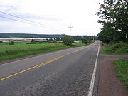
The route is the primary road serving the eastern part of Albert County
Albert County, New Brunswick
Albert County is located in southeastern New Brunswick, Canada on the Chignecto Bay of the Bay of Fundy. Prior to the abolition of county government in 1967, the county seat was Hopewell Cape...
and Fundy National Park
Fundy National Park
Fundy National Park is located on the Bay of Fundy, near the village of Alma, New Brunswick. The Park showcases both seashore habitats and highland Acadian forests...
.
Route 114's western terminus is at Route 1
New Brunswick Route 1
Route 1 is an important highway in the southern part of the Canadian province of New Brunswick. It begins in the west from the Canada-United States border at St. Stephen, and runs east for to Route 2 at River Glade....
exit 198 near Sussex Corner
Sussex Corner, New Brunswick
Sussex Corner is a Canadian village in Kings County, in south central New Brunswick.Southeast of the town of Sussex, with which it shares a border, the village was settled by Loyalists during the American Revolution...
. From there, the route follows the former Trans-Canada Highway
New Brunswick Route 2
Route 2 is a major provincial highway in the Canadian province of New Brunswick, carrying the main route of the Trans-Canada Highway in the province...
to Penobsquis
Penobsquis, New Brunswick
Penobsquis is a Canadian village in New Brunswick.It is located east of Sussex in the Kennebecasis River valley. The area has many dairy farms....
, where it turns southeast to Fundy National Park. At the park's headquarters, Route 114 descends a hill to the village of Alma
Alma, New Brunswick
Alma is a village in the parish of Alma, Albert County, New Brunswick, Canada. The village is centered on the small delta of the Upper Salmon River and Cleveland Brook, where they empty into Salisbury Bay....
.
The route continues east to Riverside-Albert
Riverside-Albert, New Brunswick
Riverside-Albert is a Canadian village in Albert County, New Brunswick.The village is composed of two separate communities, Riverside and Albert, which were amalgamated into a single municipality in 1966....
, then runs along the western coast of Shepody Bay
Shepody Bay
Shepody Bay is a 122 km² coastal wetland in New Brunswick, Canada. It was designated a Ramsar wetland of international importance on May 27, 1987, is a globally significant Important Bird Area, and is part of the Western Hemisphere Shorebird Reserve Network...
to the shire town of Hopewell Cape. Following the west bank of the Petitcodiac River
Petitcodiac River
The Petitcodiac River is a Canadian river in south-eastern New Brunswick. The river runs about through the province's Westmorland, Albert, and Kings counties, draining a watershed area of about . The region around the river features valleys, ridges, and rolling hills, and is home to a diverse...
, Route 114 turns north through Hillsborough
Hillsborough, New Brunswick
Hillsborough is a village in Albert County in the Canadian province of New Brunswick. It has a population of 1,292 . The village is situated on a hill overlooking the Petitcodiac River near Riverview, New Brunswick.- History :...
to the Moncton
Moncton, New Brunswick
Moncton is a Canadian city, located in Westmorland County, New Brunswick. The city is situated in southeastern New Brunswick, within the Petitcodiac River Valley, and lies at the geographic centre of the Maritime Provinces...
suburb of Riverview
Riverview, New Brunswick
Riverview is a Canadian town in Albert County, New Brunswick, Canada.Riverview is located on the south side of the Petitcodiac River, across from the cities of Moncton and Dieppe. Riverview has an area of , and a population density of...
. Route 114 crosses the Petitcodiac River Causeway to Moncton, where it ends at a traffic circle
Traffic circle
A traffic circle or rotary is a type of circular intersection in which traffic must travel in one direction around a central island. In some countries, traffic entering the circle has the right-of-way and drivers in the circle must yield. In many other countries, traffic entering the circle must...
.