
New Brunswick Route 15
Encyclopedia
New Brunswick
New Brunswick is one of Canada's three Maritime provinces and is the only province in the federation that is constitutionally bilingual . The provincial capital is Fredericton and Saint John is the most populous city. Greater Moncton is the largest Census Metropolitan Area...
. Starting at the north end of the Petitcodiac River Causeway, it loops around the city of Moncton on Wheeler Boulevard, then turns northeast from Dieppe
Dieppe, New Brunswick
Dieppe is a Canadian city in Westmorland County, New Brunswick.-Geography:Dieppe is located on the Petitcodiac River east of the adjacent city of Moncton...
to Shediac
Shediac, New Brunswick
Shediac is a Canadian town in Westmorland County, New Brunswick.Situated on Shediac Bay, a sub-basin of the Northumberland Strait, the town calls itself the "Lobster Capital of the World" and hosts an annual festival every July which promotes its ties to lobster fishing; the largest lobster...
. From there, it turns east and bypasses Cap-Pele
Cap-Pele, New Brunswick
Cap-Pelé is a Canadian village in Westmorland County, New Brunswick.The community's population meets the requirements for "town" status under the Municipalities Act of the Province of New Brunswick, however there has been no move to change municipal status.-Geography:It is located on the...
, then southeast to meet the Trans-Canada Highway
Trans-Canada Highway
The Trans-Canada Highway is a federal-provincial highway system that joins the ten provinces of Canada. It is, along with the Trans-Siberian Highway and Australia's Highway 1, one of the world's longest national highways, with the main route spanning 8,030 km...
at Port Elgin
Port Elgin, New Brunswick
Port Elgin is a Canadian village in Westmorland County, New Brunswick.Port Elgin is situated near the Nova Scotia border at the mouth of the Gaspareaux River where it empties into Baie Verte.-History:...
.
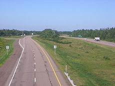
The highway is a divided freeway from Moncton to just east of Shediac, where it remains a controlled-access highway
Controlled-access highway
A controlled-access highway is a highway designed exclusively for high-speed vehicular traffic, with all traffic flow and ingress/egress regulated...
until east of Cap-Pele.
History
Route 15 only extended from Shediac to Port Elgin until the early 1970s, when the Shediac Four-Lane Highway (the first rural expressway in New Brunswick) was built from Dieppe to Shediac. Its construction was controversial, with critics alleging that it was only built to give Moncton-area politicians better access to their summer cottageCottage
__toc__In modern usage, a cottage is usually a modest, often cozy dwelling, typically in a rural or semi-rural location. However there are cottage-style dwellings in cities, and in places such as Canada the term exists with no connotations of size at all...
s in the Shediac area. A two-lane bypass of Shediac itself was built shortly afterward.
The Wheeler Boulevard was developed and constructed through the 1970s and 1980s, and was fully complete by 1989.
A two-lane bypass of Cap-Pele opened to traffic in 1998. Since then it has proven itself to be a most important and beneficial highway a lifeblood giving artery to the rest of southeastern New Brunswick.
Major intersections
| Location | Exit Number | Intersecting Roads |
|---|---|---|
| Moncton | 0 | Baig Boulevard |
| Moncton | 1 | St. George Street |
| Moncton | 3 | Killam Drive / Berry Mills Road (Route 128) |
| Moncton | 5 | Mountain Road (Route 126) |
| Moncton | 6 | Mapleton Road |
| Moncton | 7 | Connaught Avenue / Morton Avenue |
| Moncton | 8 | Archibald Street / Université de Moncton Université de Moncton The Université de Moncton is a French language university located in Moncton, New Brunswick serving the Acadian community of Atlantic Canada... |
| Moncton | 9** | Lewisville Road ( Route 134 Route 134New Brunswick Route 134 Route 134 is a Canadian secondary highway in northeast New Brunswick. The highway is actually divided by Northumberland County into a northern and southern section.... ) |
| Moncton (Halls Creek) | 9** | Main Street ( Route 106 Route 106New Brunswick Route 106 Route 106 is a highway in New Brunswick, Canada; running from an intersection with Route 1 in Petitcodiac to the Trans-Canada Highway at Sackville; a distance of 91.8 kilometres.... ) |
| Dieppe Dieppe, New Brunswick Dieppe is a Canadian city in Westmorland County, New Brunswick.-Geography:Dieppe is located on the Petitcodiac River east of the adjacent city of Moncton... |
10 | Paul Street |
| Dieppe | 16 | Dieppe Boulevard |
| Dieppe | 17 | Greater Moncton International Airport Greater Moncton International Airport Greater Moncton International Airport or Moncton/Greater Moncton International Airport is located in the city of Dieppe east northeast of downtown Moncton, New Brunswick, Canada... (eastbound only) |
| Dieppe | 19 | Route 2 New Brunswick Route 2 Route 2 is a major provincial highway in the Canadian province of New Brunswick, carrying the main route of the Trans-Canada Highway in the province... |
| Shediac Shediac, New Brunswick Shediac is a Canadian town in Westmorland County, New Brunswick.Situated on Shediac Bay, a sub-basin of the Northumberland Strait, the town calls itself the "Lobster Capital of the World" and hosts an annual festival every July which promotes its ties to lobster fishing; the largest lobster... |
31 |  Route 11 Route 11New Brunswick Route 11 Route 11 is a provincial highway in northeastern New Brunswick, Canada. The 430-kilometre long road runs from Shediac to the Quebec border near Campbellton at the Interprovinciale Bridge, following the province's eastern and northern coastlines.... / Scoudouc Road (  Route 132 Route 132New Brunswick Route 132 Route 132 is a New Brunswick provincial collector road that runs between Dieppe and Shediac.The western section is known locally as Champlain Street which consists of a four lane undivided urban arterial. The remainder of the road is a two-lane rural facility. It connects to Route 11 at its... ) |
| Shediac | 37 | Ohio Road (Route 140) |
| Barachois | 43 | Route 933 |
| Robichaud | 46 | Chemin Acadie (Route 133) |
| Cap-Pele Cap-Pele, New Brunswick Cap-Pelé is a Canadian village in Westmorland County, New Brunswick.The community's population meets the requirements for "town" status under the Municipalities Act of the Province of New Brunswick, however there has been no move to change municipal status.-Geography:It is located on the... |
53 | Route 950 New Brunswick Route 950 Route 950 is a Canadian highway in Westmorland County, New Brunswick.The 22 kilometre road runs from an intersection with Route 15 at Cap-Pelé to an intersection with Route 15 to the east in Shemogue.-Communities along Route 950:*Cap-Pelé*Bas-Cap-Pelé... |
| Cap-Pele | 58** | Chemin Acadie (Route 133) |
- * At-grade intersection
- ** At-grade intersection, exit number not posted (kilometre-post used)