

New Brunswick Route 11
Encyclopedia
Route 11 is a provincial highway in northeastern New Brunswick
, Canada
. The 430-kilometre long road runs from Shediac
to the Quebec
border near Campbellton
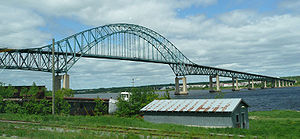
at the Interprovinciale Bridge
, following the province's eastern and northern coastlines.
Between Shediac and Miramichi
, and between Bathurst
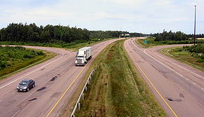
and Campbellton, it is a two-lane road with some sections designed as a Super 2 expressway
. The highway is twinned for 2 kilometres in the Shediac region near the Route 15
interchange.
in Shediac
. It runs northward as a Super 2 controlled-access highway, several kilometres inland from the Gulf of St. Lawrence, passing the towns of Bouctouche
and Richibucto
as well as Kouchibouguac National Park
. The highway reverts to a 2-lane uncontrolled access highway between the national park and the city of Miramichi
to the northwest. The highway crosses the Miramichi River
in the Miramichi borough of Chatham
on the Centennial Bridge
.
Immediately after crossing the Miramichi River, Route 11 interchanges with Route 8
(which turns north toward Bathurst
on the direct route off the bridge). To follow Route 11, one must take the exit at the interchange and then continue on a 2-lane uncontrolled access highway northeast along the coast of Miramichi Bay
and the Gulf of St. Lawrence as it runs around the perimeter of the Acadian Peninsula
. Through this region, Route 11 typically forms the main street through most of the coastal towns and settlements such as Neguac
, Caraquet
, Bertrand
, Grande-Anse
, and Stonehaven
. The only exception is a recently opened Super 2 controlled access bypass of the town of Tracadie-Sheila
.
Route 11 interchanges again with Route 8 at Bathurst
where Route 8 has its northern terminus. Route 11 becomes a Super 2 controlled access highway from Bathurst, running northwest several kilometres inland from the coast of Chaleur Bay
to the village of Tide Head
several kilometres west of the city of Campbellton
. At Tide Head, Route 11 interchanges in a T-intersection with Route 17
(Route 17 is a continuation of the direct Route 11 right-of-way).
To follow Route 11 further west to its northern terminus, one must turn at the intersection onto a 2-lane uncontrolled access local road which runs north to the Restigouche River
, then turn west and follow the river to the Interprovinciale Bridge
which crosses the river at Matapedia, Quebec
.
 Since the late 1960s, Route 11 has received several upgrades and re-designations as it progresses toward eventually becoming an expressway.
The most significant upgrade to the entire highway route along the east coast of New Brunswick was the opening of the Centennial Bridge
which replaced a ferry service and bypassed the town of Chatham
in 1967.
In 1972 a new 4-lane expressway opened between Moncton and Shediac, which was then referred to as the Shediac Four-Lane Highway or Shediac Expressway (it was subsequently numbered Route 15 and is known as the Veterans Memorial Highway). Prior to this new expressway, Route 11 followed the Shediac Road from Shediac to Moncton, terminating at Route 2
, the Trans-Canada Highway
in Lakeville
. Route 11's southern terminus was then changed to the current interchange at Route 15 in Shediac.
Controlled access Super 2 expressway sections on Route 11 were completed during the 1970s in Bathurst and the Campbellton-Dalhousie area, as well as between Shediac and Bouctouche.
During the 1980s and into the early 1990s, two long stretches of Super 2 expressway were completed on Route 11; one running from Bouctouche to Kouchibouguac National Park (bypassing Richibucto), and another running between Bathurst and Charlo, where the existing Super 2 section running east from Campbellton ended. The Super 2 section in Bathurst was also extended eastward past Salmon Beach
at the city's east end.
A bypass of Tracadie-Sheila
opened to traffic in 2002. Also, an extension to that existing bypass should be done by 2009, linking the northern end and Six-Roads, near Pokemouche.
Route 11 has recently been identified for major upgrades following completion of the twinning project on the Trans-Canada Highway (Route 2) in 2007. Initial design work is being done for upgrading the existing 4-lane section from Route 15 to Shediac Bridge (2 km), followed by construction of a new 4-lane section from Shediac Bridge to Bouctouche (twinning the existing Super 2 section).
Twinning advocates wish to have Route 11 upgraded as a 4-lane expressway for the entire section between Miramichi and Moncton, although this project will be competing for priority with similar upgrades being planned for Route 8
between Fredericton and Miramichi, Route 1
between Lepreau and St. Stephen, and Route 7
between Grand Bay-Westfield and Oromocto.
New Brunswick
New Brunswick is one of Canada's three Maritime provinces and is the only province in the federation that is constitutionally bilingual . The provincial capital is Fredericton and Saint John is the most populous city. Greater Moncton is the largest Census Metropolitan Area...
, Canada
Canada
Canada is a North American country consisting of ten provinces and three territories. Located in the northern part of the continent, it extends from the Atlantic Ocean in the east to the Pacific Ocean in the west, and northward into the Arctic Ocean...
. The 430-kilometre long road runs from Shediac
Shediac, New Brunswick
Shediac is a Canadian town in Westmorland County, New Brunswick.Situated on Shediac Bay, a sub-basin of the Northumberland Strait, the town calls itself the "Lobster Capital of the World" and hosts an annual festival every July which promotes its ties to lobster fishing; the largest lobster...
to the Quebec
Quebec
Quebec or is a province in east-central Canada. It is the only Canadian province with a predominantly French-speaking population and the only one whose sole official language is French at the provincial level....
border near Campbellton
Campbellton, New Brunswick
Campbellton is a Canadian city in Restigouche County, New Brunswick.Situated on the south bank of the Restigouche River opposite Pointe-à-la-Croix, Quebec, Campbellton was officially incorporated in 1889 and achieved city status in 1958.Forestry and tourism are major industries in the regional...
at the Interprovinciale Bridge
Interprovinciale Bridge
The Interprovinciale Bridge that crosses the Restigouche River from Matapédia, Quebec to Flatlands, New Brunswick connecting New Brunswick Route 11 to Quebec Route 132....
, following the province's eastern and northern coastlines.
Between Shediac and Miramichi
Miramichi, New Brunswick
Miramichi is the largest city in northern New Brunswick, Canada. It is situated at the mouth of the Miramichi River where it enters Miramichi Bay...
, and between Bathurst
Bathurst, New Brunswick
Bathurst is a Canadian city in Gloucester County, New Brunswick.Bathurst is situated on Bathurst Harbour, an estuary at the mouth of the Nepisiguit River at the southernmost part of Chaleur Bay....
and Campbellton, it is a two-lane road with some sections designed as a Super 2 expressway
Limited-access road
A limited-access road known by various terms worldwide, including limited-access highway, dual-carriageway and expressway, is a highway or arterial road for high-speed traffic which has many or most characteristics of a controlled-access highway , including limited or no access to adjacent...
. The highway is twinned for 2 kilometres in the Shediac region near the Route 15
New Brunswick Route 15
Route 15 is 79 km long and is in the southeastern corner of the province of New Brunswick. Starting at the north end of the Petitcodiac River Causeway, it loops around the city of Moncton on Wheeler Boulevard, then turns northeast from Dieppe to Shediac...
interchange.
Route description
The highway's southern terminus is at the interchange with Route 15New Brunswick Route 15
Route 15 is 79 km long and is in the southeastern corner of the province of New Brunswick. Starting at the north end of the Petitcodiac River Causeway, it loops around the city of Moncton on Wheeler Boulevard, then turns northeast from Dieppe to Shediac...
in Shediac
Shediac, New Brunswick
Shediac is a Canadian town in Westmorland County, New Brunswick.Situated on Shediac Bay, a sub-basin of the Northumberland Strait, the town calls itself the "Lobster Capital of the World" and hosts an annual festival every July which promotes its ties to lobster fishing; the largest lobster...
. It runs northward as a Super 2 controlled-access highway, several kilometres inland from the Gulf of St. Lawrence, passing the towns of Bouctouche
Bouctouche, New Brunswick
Bouctouche is a Canadian town in Kent County, New Brunswick and in 2006 Census the population was 2,383.The town is located at the mouth of the Bouctouche River on the coast of the Northumberland Strait, approximately 40 kilometres northeast of Moncton....
and Richibucto
Richibucto, New Brunswick
Richibucto is a Canadian town in Kent County, New Brunswick.The town is situated on the Richibucto River where it discharges into the Northumberland Strait. The town takes its name from a Mi'kmaq term meaning "river of fire"....
as well as Kouchibouguac National Park
Kouchibouguac National Park
Kouchibouguac National Park is located on the east coast of New Brunswick, north of the town of Richibucto. The park includes barrier islands, sand dunes, lagoons, salt marshes and forests. It provides habitat for seabirds, including the endangered Piping Plover, and the second largest tern colony...
. The highway reverts to a 2-lane uncontrolled access highway between the national park and the city of Miramichi
Miramichi, New Brunswick
Miramichi is the largest city in northern New Brunswick, Canada. It is situated at the mouth of the Miramichi River where it enters Miramichi Bay...
to the northwest. The highway crosses the Miramichi River
Miramichi River
The Miramichi River is a Canadian river located in the east-central part of New Brunswick. The river drains into Miramichi Bay in the Gulf of St. Lawrence...
in the Miramichi borough of Chatham
Chatham, New Brunswick
Chatham is a Canadian urban neighbourhood in the city of Miramichi, New Brunswick.Prior to municipal amalgamation in 1995, Chatham was an incorporated town in Northumberland County along the south bank of the Miramichi River opposite Douglastown...
on the Centennial Bridge
Centennial Bridge (New Brunswick)
Centennial Bridge is an arch truss bridge crossing the Miramichi River in Northumberland County, New Brunswick, Canada. The bridge is 1.1 km long, and carries New Brunswick Route 11 over the river, connecting Douglastown on the north bank with Chatham on the south bank; both communities were...
.
Immediately after crossing the Miramichi River, Route 11 interchanges with Route 8
New Brunswick Route 8
Route 8 is an important highway link between northern and southern New Brunswick, Canada. 255 kilometres long, it runs from Fredericton to Bathurst via Miramichi.-Route description:...
(which turns north toward Bathurst
Bathurst, New Brunswick
Bathurst is a Canadian city in Gloucester County, New Brunswick.Bathurst is situated on Bathurst Harbour, an estuary at the mouth of the Nepisiguit River at the southernmost part of Chaleur Bay....
on the direct route off the bridge). To follow Route 11, one must take the exit at the interchange and then continue on a 2-lane uncontrolled access highway northeast along the coast of Miramichi Bay
Miramichi Bay
Miramichi Bay is an estuary located on the west coast of the Gulf of St. Lawrence in New Brunswick, at the mouth of the Miramichi River. Miramichi Bay is separated into the "inner bay" and the "outer bay", with the division being a line of uninhabited barrier islands which are continually reshaped...
and the Gulf of St. Lawrence as it runs around the perimeter of the Acadian Peninsula
Acadian Peninsula
The Acadian Peninsula is situated in the northeastern corner of New Brunswick, Canada, encompassing portions of Gloucester and Northumberland Counties. It derives its name from the large Acadian population located there...
. Through this region, Route 11 typically forms the main street through most of the coastal towns and settlements such as Neguac
Neguac, New Brunswick
Neguac is a Canadian village in Northumberland County, New Brunswick.Situated on the north shore of Miramichi Bay at the southern end of the Acadian Peninsula, the village is located 44 kilometres northeast of Miramichi...
, Caraquet
Caraquet, New Brunswick
Caraquet is a Canadian town in Gloucester County, New Brunswick.-Location:Situated on the shore of Chaleur Bay in the Acadian Peninsula, its name is derived from the Mi'kmaq term for meeting of two rivers...
, Bertrand
Bertrand, New Brunswick
Bertrand is a Canadian village in Gloucester County, New Brunswick.The village is located on the Acadian Peninsula at the mouth of the Caraquet River where it empties into Caraquet Bay, roughly 10 km west of Caraquet....
, Grande-Anse
Grande-Anse, New Brunswick
Grande-Anse is a Canadian village in Gloucester County, New Brunswick. It is near the community of Pokeshaw.The village is located on the shore of Chaleur Bay in the Acadian Peninsula region, 25 km northwest of Caraquet and 45 kilometres east of Bathurst.The village was first settled by Acadian...
, and Stonehaven
Stonehaven, New Brunswick
Stonehaven is a Canadian rural community in Gloucester County, New Brunswick, in the parish of New Bandon. Situated about east of Bathurst on Route 11, Stonehaven is on the southern shore of the Baie des Chaleurs ....
. The only exception is a recently opened Super 2 controlled access bypass of the town of Tracadie-Sheila
Tracadie-Sheila, New Brunswick
Tracadie-Sheila [prn Tra-k-a-dee Sh-ī-la] is a Canadian town in Gloucester County, New Brunswick.Tracadie and Sheila are separate communities whose municipal governments were merged in 1991...
.
Route 11 interchanges again with Route 8 at Bathurst
Bathurst, New Brunswick
Bathurst is a Canadian city in Gloucester County, New Brunswick.Bathurst is situated on Bathurst Harbour, an estuary at the mouth of the Nepisiguit River at the southernmost part of Chaleur Bay....
where Route 8 has its northern terminus. Route 11 becomes a Super 2 controlled access highway from Bathurst, running northwest several kilometres inland from the coast of Chaleur Bay
Chaleur Bay
frame| Satellite image of Chaleur Bay . Chaleur Bay is the large bay opening to the east;the [[Gaspé Peninsula]] appears to the north and the [[Gulf of St...
to the village of Tide Head
Tide Head, New Brunswick
Tide Head is a Canadian village in Restigouche County, New Brunswick.-Geography:Located on the south bank of the Restigouche River 10 km west of Campbellton, the village is situated where the tides on the Restigouche River cease to become visible, the reason for its name.-History:The first...
several kilometres west of the city of Campbellton
Campbellton, New Brunswick
Campbellton is a Canadian city in Restigouche County, New Brunswick.Situated on the south bank of the Restigouche River opposite Pointe-à-la-Croix, Quebec, Campbellton was officially incorporated in 1889 and achieved city status in 1958.Forestry and tourism are major industries in the regional...
. At Tide Head, Route 11 interchanges in a T-intersection with Route 17
New Brunswick Route 17
Route 17 is long and runs from the Canada-U.S. border in Saint-Leonard to Route 11 at Tide Head near Campbellton. Saint-Quentin and Kedgwick are other towns along the route. With the exception of those towns, the highway runs almost entirely through sparsely populated forest land. It is the only...
(Route 17 is a continuation of the direct Route 11 right-of-way).
To follow Route 11 further west to its northern terminus, one must turn at the intersection onto a 2-lane uncontrolled access local road which runs north to the Restigouche River
Restigouche River
The Restigouche River is a river that flows across the northwestern part of the province of New Brunswick and the southeastern part of Quebec....
, then turn west and follow the river to the Interprovinciale Bridge
Interprovinciale Bridge
The Interprovinciale Bridge that crosses the Restigouche River from Matapédia, Quebec to Flatlands, New Brunswick connecting New Brunswick Route 11 to Quebec Route 132....
which crosses the river at Matapedia, Quebec
Matapédia, Quebec
Matapédia is a village at the southern tip of the Gaspé peninsula, in Eastern Quebec, Canada. Matapedia is located on the 132 highway. Its name comes from a Mi'kmaq language word meaning "river junction", as the Matapédia River crosses it, at the junction of the Restigouche River...
.
History
The most significant upgrade to the entire highway route along the east coast of New Brunswick was the opening of the Centennial Bridge
Centennial Bridge (New Brunswick)
Centennial Bridge is an arch truss bridge crossing the Miramichi River in Northumberland County, New Brunswick, Canada. The bridge is 1.1 km long, and carries New Brunswick Route 11 over the river, connecting Douglastown on the north bank with Chatham on the south bank; both communities were...
which replaced a ferry service and bypassed the town of Chatham
Chatham, New Brunswick
Chatham is a Canadian urban neighbourhood in the city of Miramichi, New Brunswick.Prior to municipal amalgamation in 1995, Chatham was an incorporated town in Northumberland County along the south bank of the Miramichi River opposite Douglastown...
in 1967.
In 1972 a new 4-lane expressway opened between Moncton and Shediac, which was then referred to as the Shediac Four-Lane Highway or Shediac Expressway (it was subsequently numbered Route 15 and is known as the Veterans Memorial Highway). Prior to this new expressway, Route 11 followed the Shediac Road from Shediac to Moncton, terminating at Route 2
New Brunswick Route 2
Route 2 is a major provincial highway in the Canadian province of New Brunswick, carrying the main route of the Trans-Canada Highway in the province...
, the Trans-Canada Highway
Trans-Canada Highway
The Trans-Canada Highway is a federal-provincial highway system that joins the ten provinces of Canada. It is, along with the Trans-Siberian Highway and Australia's Highway 1, one of the world's longest national highways, with the main route spanning 8,030 km...
in Lakeville
Lakeville, New Brunswick
Lakeville is a community in the Canadian province of New Brunswick. This small village is located between Centreville and Woodstock. It is located on route 560 in Carleton County. It has two churches, a post office, a fire hall, a park, a community center and no school. Students from the area are...
. Route 11's southern terminus was then changed to the current interchange at Route 15 in Shediac.
Controlled access Super 2 expressway sections on Route 11 were completed during the 1970s in Bathurst and the Campbellton-Dalhousie area, as well as between Shediac and Bouctouche.
During the 1980s and into the early 1990s, two long stretches of Super 2 expressway were completed on Route 11; one running from Bouctouche to Kouchibouguac National Park (bypassing Richibucto), and another running between Bathurst and Charlo, where the existing Super 2 section running east from Campbellton ended. The Super 2 section in Bathurst was also extended eastward past Salmon Beach
Salmon Beach, New Brunswick
Salmon Beach is a settlement in New Brunswick....
at the city's east end.
A bypass of Tracadie-Sheila
Tracadie-Sheila, New Brunswick
Tracadie-Sheila [prn Tra-k-a-dee Sh-ī-la] is a Canadian town in Gloucester County, New Brunswick.Tracadie and Sheila are separate communities whose municipal governments were merged in 1991...
opened to traffic in 2002. Also, an extension to that existing bypass should be done by 2009, linking the northern end and Six-Roads, near Pokemouche.
Route 11 has recently been identified for major upgrades following completion of the twinning project on the Trans-Canada Highway (Route 2) in 2007. Initial design work is being done for upgrading the existing 4-lane section from Route 15 to Shediac Bridge (2 km), followed by construction of a new 4-lane section from Shediac Bridge to Bouctouche (twinning the existing Super 2 section).
Twinning advocates wish to have Route 11 upgraded as a 4-lane expressway for the entire section between Miramichi and Moncton, although this project will be competing for priority with similar upgrades being planned for Route 8
New Brunswick Route 8
Route 8 is an important highway link between northern and southern New Brunswick, Canada. 255 kilometres long, it runs from Fredericton to Bathurst via Miramichi.-Route description:...
between Fredericton and Miramichi, Route 1
New Brunswick Route 1
Route 1 is an important highway in the southern part of the Canadian province of New Brunswick. It begins in the west from the Canada-United States border at St. Stephen, and runs east for to Route 2 at River Glade....
between Lepreau and St. Stephen, and Route 7
New Brunswick Route 7
Route 7 is 97 kilometres long and runs from Fredericton, near an interchange with Route 8, to an interchange with Route 1 in Saint John. Most of the highway is either a divided expressway or has limited access....
between Grand Bay-Westfield and Oromocto.
Southern section
| Location | Exit Number | Intersecting Roads |
|---|---|---|
| Shediac Shediac, New Brunswick Shediac is a Canadian town in Westmorland County, New Brunswick.Situated on Shediac Bay, a sub-basin of the Northumberland Strait, the town calls itself the "Lobster Capital of the World" and hosts an annual festival every July which promotes its ties to lobster fishing; the largest lobster... |
0 |  Route 15 Route 15New Brunswick Route 15 Route 15 is 79 km long and is in the southeastern corner of the province of New Brunswick. Starting at the north end of the Petitcodiac River Causeway, it loops around the city of Moncton on Wheeler Boulevard, then turns northeast from Dieppe to Shediac... |
| Shediac | 1 | Main Street (Route 133) |
| Shediac | 2 | Moncton Road ( Route 134 Route 134New Brunswick Route 134 Route 134 is a Canadian secondary highway in northeast New Brunswick. The highway is actually divided by Northumberland County into a northern and southern section.... ) |
| Shediac Bridge | 7 | Shediac River Road |
| Cocagne Cocagne, New Brunswick Cocagne is a Canadian community in Kent County, New Brunswick.It is located at the mouth of the Cocagne River on the Northumberland Strait.... |
15 | Route 535 |
| McKees Mills | 27 |  Route 115 Route 115New Brunswick Route 115 Route 115 is a highway in New Brunswick, Canada; running from a junction with Route 134 in the Lewisville neighbourhood of Moncton to Route 134 in Saint-François-de-Kent Route 115 is a highway in New Brunswick, Canada; running from a junction with Route 134 in the Lewisville neighbourhood of... |
| Bouctouche Bouctouche, New Brunswick Bouctouche is a Canadian town in Kent County, New Brunswick and in 2006 Census the population was 2,383.The town is located at the mouth of the Bouctouche River on the coast of the Northumberland Strait, approximately 40 kilometres northeast of Moncton.... |
29 | Sheridan Road |
| Bouctouche | 32 | Irving Boulevard (Route 515) |
| St-Pierre-de-Kent | 36 | Route 134 |
| Ste-Anne-de-Kent | 42 | Chemin Grattan |
| Rexton Rexton, New Brunswick Rexton is a Canadian village in Kent County, New Brunswick.Situated on the Richibucto River, the village was originally inhabited by Mi'kmaqs, many of whose descendants still reside in the nearby Elsipogtog First Nation, formerly referred to as the Big Cove Band... |
53 | Main Street ( Route 134) |
| Richibucto Richibucto, New Brunswick Richibucto is a Canadian town in Kent County, New Brunswick.The town is situated on the Richibucto River where it discharges into the Northumberland Strait. The town takes its name from a Mi'kmaq term meaning "river of fire".... |
57 | Main Street ( Route 134) |
| Saint-Charles Saint-Charles, New Brunswick Saint-Charles is a settlement in Kent County, New Brunswick.... |
64 | Chemin Saint-Charles |
| St-Louis-de-Kent | 69 | Rue Beausejour |
| Kouchibouguac Kouchibouguac, New Brunswick Kouchibouguac is a community in the Canadian province of New Brunswick.... |
75 | Route 480 / Route 117 |
| Kouchibouguac | 79** | Route 134 |
| St. Margarets St. Margarets, New Brunswick St. Margarets is a settlement in New Brunswick.... |
95** | Route 440 |
| Black River Black River, New Brunswick Black River is a small community just outside of Saint John in the Canadian province of New Brunswick. There are beautiful beaches in Black River. A great place to visit the Bay of Fundy.... |
106** | Black River Road |
| Upper Napan | 115** | North Napan Road |
| Miramichi Miramichi, New Brunswick Miramichi is the largest city in northern New Brunswick, Canada. It is situated at the mouth of the Miramichi River where it enters Miramichi Bay... (Chatham) |
117** | King Street |
| Miramichi (Chatham) | 119 | University Avenue (Route 117) |
| Miramichi (Chatham) | 120 | Church Street |
| Miramichi (Douglastown) | 121** | King George Highway ( Route 8 Route 8New Brunswick Route 8 Route 8 is an important highway link between northern and southern New Brunswick, Canada. 255 kilometres long, it runs from Fredericton to Bathurst via Miramichi.-Route description:... ) |
Tracadie-Sheila Bypass
| Location | Exit Number | Intersecting Roads |
|---|---|---|
| Sheila | 192 | Chemin Pointe-des-Ferguson (Route 370) |
| Tracadie | 194 | Rue Principale |
| Tracadie | 198 | Chemin Riviere-a-la-Truite |
| Losier Settlement Losier Settlement, New Brunswick Losier Settlement is a settlement in New Brunswick.... |
203 | Rue Principale |
Northern section
| Location | Exit Number | Intersecting Roads |
|---|---|---|
| Janeville Janeville, New Brunswick Janeville is a community in the Canadian province of New Brunswick.... |
282** | Chemin des Caps (Route 191) |
| Bathurst Bathurst, New Brunswick Bathurst is a Canadian city in Gloucester County, New Brunswick.Bathurst is situated on Bathurst Harbour, an estuary at the mouth of the Nepisiguit River at the southernmost part of Chaleur Bay.... |
300 | Miramichi Avenue ( Route 134 New Brunswick Route 134 Route 134 is a Canadian secondary highway in northeast New Brunswick. The highway is actually divided by Northumberland County into a northern and southern section.... ) |
| Bathurst | 301 | Route 8 New Brunswick Route 8 Route 8 is an important highway link between northern and southern New Brunswick, Canada. 255 kilometres long, it runs from Fredericton to Bathurst via Miramichi.-Route description:... |
| Bathurst / Big River Big River, New Brunswick Big River is a Canadian rural community in Gloucester County, New Brunswick.... |
304 | King Street (Route 430) |
| Bathurst | 308 | St-Anne Street |
| Bathurst | 310 | Vanier Boulevard (Route 180 New Brunswick Route 180 Route 180 is a collector highway in northern New Brunswick, Canada.-Communities along Route 180:* Saint-Quentin* Five Fingers* Rang-Seize* Rang-Dix-Huit* Simpson Field* South Tetagouche* Sainte-Anne* Bathurst... ) |
| Bathurst | 311 | Sunset Drive (Route 315 New Brunswick Route 315 Route 315 is a local highway in northwestern New Brunswick, Canada. The road runs from New Brunswick Route 180 in Bathurst to its northern terminus at New Brunswick Route 134 in Petit-Rocher, its route running mostly parallel to the west with New Brunswick Route 11.-Communities along Route 315:*... ) |
| Beresford Beresford, New Brunswick Beresford is a Canadian town in Gloucester County, New Brunswick.It is situated on the shore of Chaleur Bay immediately north of the city of Bathurst... |
318 | Chemin Acadie |
| Nigadoo Nigadoo, New Brunswick Nigadoo is a Canadian village in Gloucester County, New Brunswick.The village is located at the mouth of the Nigadoo River on Chaleur Bay, 15 km northwest of Bathurst and adjacent to Beresford.... |
321 | Chemin du Moulin |
| Petit-Rocher Petit-Rocher, New Brunswick Petit-Rocher is a Canadian village in Gloucester County, New Brunswick. Located on Chaleur Bay 20 km northwest of Bathurst, Petit-Rocher's residents are 92% Francophone Acadian... |
326 | Chemin Laplante |
| Pointe-Verte Pointe-Verte, New Brunswick Pointe-Verte is a Canadian village in Gloucester County, New Brunswick.Located on Chaleur Bay 30 km north of Bathurst, the village's main industry is lobster and scallop fishing, as well as forestry.... |
333 | Chemin de la Gare |
| Belledune Belledune, New Brunswick Belledune is a Canadian village in Gloucester County, New Brunswick.The little community of Belledune represents an amalgamation of Jacquet River, Armstrong Brook, and Belledune in 1994... |
344 | Chemin Turgeon |
| Jacquet River Jacquet River, New Brunswick Jacquet River is a former municipality in Restigouche County, New Brunswick, Canada. It is now part of the municipality of Belledune, and has a population of about 1,200 people.... |
351 | Jacquet River Drive |
| Nash Creek Nash Creek, New Brunswick Nash Creek is a Canadian rural community in Restigouche County, New Brunswick.Located in the eastern part of the county along the south shore of Chaleur Bay, Nash Creek derives its name from a creek of the same name.... |
357 | Hayes Road |
| Charlo Charlo, New Brunswick Charlo is a Canadian village in Restigouche County, New Brunswick.Situated on the south shore of Chaleur Bay, the community was first settled by Acadians in 1799 and incorporated in 1966.... |
375 | MacPherson Road |
| Charlo | 385 | Craig Road |
| Eel River Crossing Eel River Crossing, New Brunswick Eel River Crossing is a Canadian village in Restigouche County, New Brunswick.Usually simplified to simply Eel River, the village is situated on the Eel River... |
388 | Route 280 New Brunswick Route 280 Route 280 is an local highway in northeast New Brunswick, Canada .-Communities along Route 280:* McLeods* Upper Dundee* Shannonvale* Dundee* Eel River Cove* Charlo... |
| Dalhousie Dalhousie, New Brunswick Dalhousie is a Canadian town located in Restigouche County, New Brunswick.- History :Dalhousie is the shire town of Restigouche County and dates European settlement to 1800. The Town of Dalhousie has been through some very distinct periods between its founding in 1825 and today... |
391 | Darlington Road ( Route 275 Route 275New Brunswick Route 275 Route 275 is a local highway in northeast New Brunswick, Canada .-Communities along Route 275:* Glencoe* Val-Melanson* Saint-Arthur* McKendrick* Maltais* Blair Athol* Upper Balmoral* Balmoral* Selwood* Eel River Crossing* Darlington... ) |
| Dalhousie Junction Dalhousie Junction, New Brunswick Dalhousie Junction is an unincorporated community in Restigouche County, New Brunswick, Canada.-References:... |
397 | Blair Malcolm Road |
| Dundee Dundee, New Brunswick Dundee is a community in Restigouche County, New Brunswick, Canada. It is part of the village of Eel River Crossing.-References:... |
403 | Route 280 |
| Campbellton Campbellton, New Brunswick Campbellton is a Canadian city in Restigouche County, New Brunswick.Situated on the south bank of the Restigouche River opposite Pointe-à-la-Croix, Quebec, Campbellton was officially incorporated in 1889 and achieved city status in 1958.Forestry and tourism are major industries in the regional... |
412 | Lily Lake Road |
| Atholville Atholville, New Brunswick Atholville is a Canadian village in Restigouche County A4L, New Brunswick.It is located on the south bank of the Restigouche River upstream and west of the city of Campbellton.... |
415 | Val d'Amour Road (Route 270) |
| Tide Head Tide Head, New Brunswick Tide Head is a Canadian village in Restigouche County, New Brunswick.-Geography:Located on the south bank of the Restigouche River 10 km west of Campbellton, the village is situated where the tides on the Restigouche River cease to become visible, the reason for its name.-History:The first... |
423** |  Route 17 Route 17New Brunswick Route 17 Route 17 is long and runs from the Canada-U.S. border in Saint-Leonard to Route 11 at Tide Head near Campbellton. Saint-Quentin and Kedgwick are other towns along the route. With the exception of those towns, the highway runs almost entirely through sparsely populated forest land. It is the only... |