

New Brunswick Route 1
Encyclopedia
Route 1 is an important highway in the southern part of the Canadian
province of New Brunswick
. It begins in the west from the Canada-United States border
at St. Stephen
, and runs east for 231 kilometres (143.5 mi) to Route 2
at River Glade
.
The eastern 155 km of Route 1 has been upgraded to a 4-lane controlled-access freeway (from Lepreau to River Glade). The remaining 86 km western portion of the highway running through Charlotte County
is mostly 2-lane (non-divided) with a mixture of controlled and non-controlled access; this section is scheduled to be upgraded by 2013.
. The development of controlled access expressway
s only began in the 1960s and only around the largest communities. The majority of early provincial highway improvements merely consisted of upgrading local roads.
, then back north and east (still along local roads) until reaching Saint John
where it followed Manawagonish Road through the former city of Lancaster and was later diverted to follow the "Golden Mile" immediately south of Manawagonish Road. It crossed the Saint John River at the Reversing Falls Bridge
before proceeding on Douglas Avenue into the north end of the city. From there it went over to Rothesay Avenue and followed the shores of the Kennebecasis River
up the valley to Sussex where it ended.
 The earliest significant upgrade to this routing came in the late 1960s during an urban-renewal project in Saint John which saw the construction of a new highway (the Saint John Throughway) to bypass increased truck traffic around the city. Several alignment options were examined with the majority of citizens wanting the highway to go north of the city through the suburb of Millidgeville
from where an easier crossing of the Reversing Falls
gorge could be attempted.
However, the city, along with the provincial and federal governments, decided to bargain with the Canadian Pacific Railway
(CPR) to purchase the majority of the Mill Street Yard near the neo-gothic
Union Station for a highway alignment which would run through the middle of the city (somewhat like the infamous Interstate 93
alignment which was built through Boston).
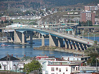
The removal of the rail yard and historic station coincided with the federally-controlled National Harbours Board building the 4-lane Saint John Harbour Bridge
downstream of the Reversing Falls which opened in 1968. Part of this deal involved the NHB collecting a 25¢ toll in each direction, however the toll cannot be raised without federal, provincial and municipal agreement, until 2007 when the toll was increased to 50¢. The new bridge also had the added effect of cutting the upper part of Saint John Harbour off from large ship traffic.
In a related project, in 1969, the federal and provincial governments worked with CPR to revamp the Saint John-Digby ferry service by building a new terminal in the city's west end, along with interchanges off the new expressway.
in the west, to where it met Rothesay Avenue in the east at Coldbrook but its construction coincided with the decline of rail traffic and rise of truck traffic and personal automobile travel. The Saint John area soon saw the growth of suburbs in the towns of Rothesay and Quispamsis in the Kennebecasis River valley, which were located just outside the Bay of Fundy's "fog belt."
In the 1970s, an extension to the throughway was built east from Rothesay Avenue to just past the town of Quispamsis where Route 1 reverted to local roads up the valley to Hampton and beyond. This controlled-access 2-lane section bypassing these towns was named the Mackay Highway, having been built through a stretch of timberland formerly owned by the locally prominent Mackay family.
In the mid-1990s, a 2-lane bypass of Hampton was built up the Kennebecasis Valley from where the Mackay Highway ended, rejoining local roads at Norton. Another bypass was built from Oak Bay to Digdeguash to avoid the circuitous routing down the St. Andrews peninsula and through the town of the same name. Further 2-lane bypasses were built around St. George and on the outskirts of Sussex where an interchange with the Trans-Canada Highway
was built.
who was focused on improving the province's business climate. One of the government's major tasks was to revamp provincial transportation infrastructure and McKenna entered into aggressive negotiations with the federal government of prime minister Brian Mulroney
to secure federal funding of new highway projects. McKenna viewed the Trans-Canada and Route 1 in New Brunswick as being partially a federal responsibility since they funnelled the majority of Atlantic Canada's highway traffic to the U.S. and central Canada. The signing of the Canada-U.S. Free Trade Agreement in 1989, coupled with federal approval for numerous railway line abandonments in the Maritimes during the 1980s, led to predictions of further highway traffic growth on New Brunswick highways in the 1990s.
Under the remainder of the McKenna administration's years of power (until 1997), Route 1 saw 4-lane expansion and upgrading between Lorneville to Lepreau in the west and between Coldbrook and Apohaqui
(near Sussex) in the east. A small 4-lane re-alignment was also built between St. George and Pennfield. The Trans-Canada Highway (Route 2) was also upgraded to 4-lanes between Penobsquis and Peticodiac.
Upgrades to Route 1 continued in the late 2000s, with a 4-lane section between St. Stephen and the Route 127 junction at Waweig opening to traffic in December 2008. The St. Stephen Bypass, which had been partially open since 1993 as a 2-lane controlled access route to siphon traffic to the Milltown border crossing, was also upgraded and officially became part of Route 1 at this time. The bypass was completed in November 2009 with the opening of the International Avenue Bridge
to Calais, Maine.
It was announced on September 5, 2008 that the remaining stretch of Route 1 that connects to the United States will be twinned. The estimated cost will be $1.2 Billion (including maintenance and not accounting for inflation) with PPP Canada contributing half the cost of construction for an amount estimated to be about $290 million. Work is expected to be completed by July 2013.The project will be completed in much the same manner as the upgrade and realignment of the Trans-Canada Highway. A private consortium will be chosen through a tendering process, and they will be responsible for the design, and construction for the sections not yet upgraded to 4-lane status. After construction is completed the company formed by the consortium will be responsible for the maintenance of the highway from the US-Canada border crossing, to the interchange with Route 2 at River Glade, 15 km west of Moncton.
Construction on the final 4 lane sections of Highway 1 commenced in the spring of 2010 and is slated for completion in 2013.
highway to carry the Trans-Canada Highway
(Route 2
) in a new alignment from a point west of Fredericton
to a point on the existing TCH west of Moncton at River Glade
.
The toll issue was not without controversy as it led to the downfall of McKenna's successor, Camille Theriault
in 1999 to PC
leader Bernard Lord
. The highway was built, but tolls were removed from most portions of the highway before they opened and this portion of the privately built (and owned) re-alignment of the Trans-Canada Highway has a hidden toll which is charged to the provincial government, thus motorists do not directly pay for their highway usage.
The new alignment of the Trans-Canada Highway opened in October, 2001 and at this time the portion of the old TCH which ran between River Glade and Sussex was re-designated as part of Route 1, extending the eastern terminus of this highway approximately 40 km (24.9 mi). Plans called for completion of a 4-lane bypass to replace the old TCH alignment around Sussex and construction took place from 2000–2004. A portion of the old TCH alignment from Sussex toward Fredericton has been re-designated as Route 10
and a re-aligned interchange has been built at Sussex.
led to the redesign of highway exit 119. Exit 119-B, west-bound, was widened to allow these longer transport truck configurations to navigate the exit. On the opposite side of the highway, the two east-bound on-ramps were combined into a wider single ramp, again to allow easier navigation for the longer transport trucks to navigate.
A east-bound exit was never officially available at exit 128, as it was only a private truck entrance into Strescon's property. In the fall of 2007, this exit was rebuilt into an official exit to allow east-bound traffic access to Rothesay Ave. East-bound traffic can now exit/enter to/from Rothesay Ave (via Ashburn Road) and west-bound traffic can exit/enter to/from Foster Thurston Drive. There is no overpass at this exit.
by 2012.
!Location
!km
!#
!Destinations
!Notes
|-
|rowspan=3|St Stephen
|
|4
| Church St.
|-
|
|7
| to
|-
|
|9
| to
|signed as 9A and 9B eastbound
|-
|Oak Bay
|
|13
|St. David Ridge Road to
|-
|Waweig
|
|25
|
|
|-
|Digdeguash
|
|39
|
|At-grade
|-
|Bethel
|42
|
|
|At-grade
|-
|rowspan=2|St. George
|
|52
|Brunswick Street to
|At-grade, eastbound access only
|-
|
|56
|
|-
|Pennfield
|
|60
|
|-
|Lepreau
|
|86
|
|-
|Musquash
|
|96
|
|-
|Prince of Wales
|
|103
|Prince of Wales
|-
|rowspan=12|Saint John
|
|112
|
|-
|
|114
|
|-
|
|117
|
|Westbound exit only
|-
|
|119
|
|Signed as exits 119A (Bleury Street) and 119B (Catherwood Street)
|-
|
|120
|Ludlow Street, Market Place – Digby Ferry
|-
|
|121
|
|Eastbound exit and westbound entrance
|-
|
|122
|
|Eastbound exit and westbound entrance
|-
|
|123
|
|-
|
|125
|
|No eastbound exit
|-
|
|128
|
|eastbound only
|-
|
|128
|Foster Thurston Drive
|westbound only
|-
|
|129
|
|-
|rowspan=2|Rothesay
|
|133
|
|-
|
|137
|
|Signed as exits 137A (Route 111) and 137B (to Route 100)
|-
|rowspan=2|Quispamsis
|
|141
|
|-
|
|142
|
|Eastbound exit and westbound entrance
|-
|Hampton
|
|158
|
|-
|Bloomfield
|
|166
|Bloomfield
|-
|Norton
|
|175
|
|-
|rowspan=3|Sussex
|
|192
|
|-
|
|193
|
|No westbound entrance
|-
|
|195
|
|-
|Sussex Corner
|
|198
|
|-
|Penobsquis
|
|211
|
|-
|Anagance
|
|223
|
|-
|Petitcodiac
|
|233
|
|-
|rowspan=2|River Glade
|
|239
|
|-
|240
|
|
|Eastbound exit and westbound entrance
Canada
Canada is a North American country consisting of ten provinces and three territories. Located in the northern part of the continent, it extends from the Atlantic Ocean in the east to the Pacific Ocean in the west, and northward into the Arctic Ocean...
province of New Brunswick
New Brunswick
New Brunswick is one of Canada's three Maritime provinces and is the only province in the federation that is constitutionally bilingual . The provincial capital is Fredericton and Saint John is the most populous city. Greater Moncton is the largest Census Metropolitan Area...
. It begins in the west from the Canada-United States border
Canada-United States border
The Canada–United States border, officially known as the International Boundary, is the longest border in the world. The terrestrial boundary is 8,891 kilometers long, including 2,475 kilometres shared with Alaska...
at St. Stephen
St. Stephen, New Brunswick
St. Stephen is a Canadian town in Charlotte County, New Brunswick, situated on the east bank of the St. Croix River at .-Climate:...
, and runs east for 231 kilometres (143.5 mi) to Route 2
New Brunswick Route 2
Route 2 is a major provincial highway in the Canadian province of New Brunswick, carrying the main route of the Trans-Canada Highway in the province...
at River Glade
River Glade, New Brunswick
River Glade is a Canadian rural community in Westmorland County, New Brunswick....
.
The eastern 155 km of Route 1 has been upgraded to a 4-lane controlled-access freeway (from Lepreau to River Glade). The remaining 86 km western portion of the highway running through Charlotte County
Charlotte County, New Brunswick
Charlotte County is located in the southwestern portion of New Brunswick, Canada.In most of the county, fishing and aquaculture dominate the local economy, although the town of St. Andrews is a tourist mecca and St...
is mostly 2-lane (non-divided) with a mixture of controlled and non-controlled access; this section is scheduled to be upgraded by 2013.
History
The majority of road development in New Brunswick follows settlement patterns which pre-dated motor transport, thus most communities developed along navigable waterways or were served by railwaysRail transport
Rail transport is a means of conveyance of passengers and goods by way of wheeled vehicles running on rail tracks. In contrast to road transport, where vehicles merely run on a prepared surface, rail vehicles are also directionally guided by the tracks they run on...
. The development of controlled access expressway
Limited-access road
A limited-access road known by various terms worldwide, including limited-access highway, dual-carriageway and expressway, is a highway or arterial road for high-speed traffic which has many or most characteristics of a controlled-access highway , including limited or no access to adjacent...
s only began in the 1960s and only around the largest communities. The majority of early provincial highway improvements merely consisted of upgrading local roads.
Early route
Route 1 initially followed local roads from St. Stephen eastward to Oak Bay where it swung south to the town of St. AndrewsSt. Andrews, New Brunswick
St. Andrews is a Canadian town in Charlotte County, New Brunswick.It is sometimes referred to in tourism marketing by its unofficial nickname "St. Andrews-by-the-sea".-Geography:St...
, then back north and east (still along local roads) until reaching Saint John
Saint John, New Brunswick
City of Saint John , or commonly Saint John, is the largest city in the province of New Brunswick, and the first incorporated city in Canada. The city is situated along the north shore of the Bay of Fundy at the mouth of the Saint John River. In 2006 the city proper had a population of 74,043...
where it followed Manawagonish Road through the former city of Lancaster and was later diverted to follow the "Golden Mile" immediately south of Manawagonish Road. It crossed the Saint John River at the Reversing Falls Bridge
Reversing Falls Bridge
The Reversing Falls Bridge is a 2-lane highway bridge crossing the Saint John River at Saint John, New Brunswick, Canada. It carries New Brunswick Route 100 across the river and there is no toll for its use.-History:...
before proceeding on Douglas Avenue into the north end of the city. From there it went over to Rothesay Avenue and followed the shores of the Kennebecasis River
Kennebecasis River
The Kennebecasis River is a tributary of the Saint John River in southern New Brunswick, Canada. The name Kennebecasis is thought to be derived from the Mi'kmaq "Kenepekachiachk", meaning "little long bay place." It runs for approximately 95 kilometres, draining an area in the Caledonia Highlands,...
up the valley to Sussex where it ended.
Saint John Throughway
Millidgeville, New Brunswick
Millidgeville is a Canadian neighbourhood in the city of Saint John, New Brunswick.Millidgeville is situated on the northern edge of the city, on Brothers Cove off the Kennebecasis River at the point where that westerly flowing river meets the southerly flowing St. John River...
from where an easier crossing of the Reversing Falls
Reversing Falls
The Reversing Falls are a series of rapids on the Saint John River located in Saint John, New Brunswick, Canada, where the river runs through a narrow gorge before emptying into the Bay of Fundy....
gorge could be attempted.
However, the city, along with the provincial and federal governments, decided to bargain with the Canadian Pacific Railway
Canadian Pacific Railway
The Canadian Pacific Railway , formerly also known as CP Rail between 1968 and 1996, is a historic Canadian Class I railway founded in 1881 and now operated by Canadian Pacific Railway Limited, which began operations as legal owner in a corporate restructuring in 2001...
(CPR) to purchase the majority of the Mill Street Yard near the neo-gothic
Gothic architecture
Gothic architecture is a style of architecture that flourished during the high and late medieval period. It evolved from Romanesque architecture and was succeeded by Renaissance architecture....
Union Station for a highway alignment which would run through the middle of the city (somewhat like the infamous Interstate 93
Interstate 93
Interstate 93 is an Interstate Highway in the New England section of the United States. Its southern terminus is in Canton, Massachusetts, in the Boston metropolitan area, at Interstate 95; its northern terminus is near St. Johnsbury, Vermont, at Interstate 91...
alignment which was built through Boston).
The removal of the rail yard and historic station coincided with the federally-controlled National Harbours Board building the 4-lane Saint John Harbour Bridge
Saint John Harbour Bridge
The Saint John Harbour Bridge is a hollow box, haunched girder bridge crossing Saint John Harbour at the mouth of the Saint John River in Saint John, New Brunswick, Canada.-History:...
downstream of the Reversing Falls which opened in 1968. Part of this deal involved the NHB collecting a 25¢ toll in each direction, however the toll cannot be raised without federal, provincial and municipal agreement, until 2007 when the toll was increased to 50¢. The new bridge also had the added effect of cutting the upper part of Saint John Harbour off from large ship traffic.
In a related project, in 1969, the federal and provincial governments worked with CPR to revamp the Saint John-Digby ferry service by building a new terminal in the city's west end, along with interchanges off the new expressway.
Mackay Highway
The Saint John Throughway only extended from Spruce Lake at LornevilleLorneville, New Brunswick
Lorneville is a small Canadian coastal community located in the western part of Saint John County, New Brunswick.It is located within the boundaries of the city of Saint John.-External links:*...
in the west, to where it met Rothesay Avenue in the east at Coldbrook but its construction coincided with the decline of rail traffic and rise of truck traffic and personal automobile travel. The Saint John area soon saw the growth of suburbs in the towns of Rothesay and Quispamsis in the Kennebecasis River valley, which were located just outside the Bay of Fundy's "fog belt."
In the 1970s, an extension to the throughway was built east from Rothesay Avenue to just past the town of Quispamsis where Route 1 reverted to local roads up the valley to Hampton and beyond. This controlled-access 2-lane section bypassing these towns was named the Mackay Highway, having been built through a stretch of timberland formerly owned by the locally prominent Mackay family.
Extending controlled access
In a new focus on improving arterial highways in the province, the provincial government during the 1960s-1980s undertook other improvements to Route 1, namely in building new sections (or designating existing sections) as controlled access. This resulted in the establishment of maximum speed limits of 100 km/h (65 mph) on these sections.In the mid-1990s, a 2-lane bypass of Hampton was built up the Kennebecasis Valley from where the Mackay Highway ended, rejoining local roads at Norton. Another bypass was built from Oak Bay to Digdeguash to avoid the circuitous routing down the St. Andrews peninsula and through the town of the same name. Further 2-lane bypasses were built around St. George and on the outskirts of Sussex where an interchange with the Trans-Canada Highway
Trans-Canada Highway
The Trans-Canada Highway is a federal-provincial highway system that joins the ten provinces of Canada. It is, along with the Trans-Siberian Highway and Australia's Highway 1, one of the world's longest national highways, with the main route spanning 8,030 km...
was built.
4-lane construction
The provincial government changed in 1987 with the election of Premier Frank McKennaFrank McKenna
Francis Joseph "Frank" McKenna, PC, OC, ONB, QC is a Canadian businessman and former politician and diplomat. He is currently Deputy Chairman of the Toronto-Dominion Bank. He served as Canadian Ambassador to the United States from 2005 to 2006...
who was focused on improving the province's business climate. One of the government's major tasks was to revamp provincial transportation infrastructure and McKenna entered into aggressive negotiations with the federal government of prime minister Brian Mulroney
Brian Mulroney
Martin Brian Mulroney, was the 18th Prime Minister of Canada from September 17, 1984, to June 25, 1993 and was leader of the Progressive Conservative Party of Canada from 1983 to 1993. His tenure as Prime Minister was marked by the introduction of major economic reforms, such as the Canada-U.S...
to secure federal funding of new highway projects. McKenna viewed the Trans-Canada and Route 1 in New Brunswick as being partially a federal responsibility since they funnelled the majority of Atlantic Canada's highway traffic to the U.S. and central Canada. The signing of the Canada-U.S. Free Trade Agreement in 1989, coupled with federal approval for numerous railway line abandonments in the Maritimes during the 1980s, led to predictions of further highway traffic growth on New Brunswick highways in the 1990s.
Under the remainder of the McKenna administration's years of power (until 1997), Route 1 saw 4-lane expansion and upgrading between Lorneville to Lepreau in the west and between Coldbrook and Apohaqui
Apohaqui, New Brunswick
Apohaqui is a Canadian rural community in Kings County, New Brunswick.The name Apohaqui was translated from the Maliseet language, and means "The joining of two waters" or "the joining of two rivers"...
(near Sussex) in the east. A small 4-lane re-alignment was also built between St. George and Pennfield. The Trans-Canada Highway (Route 2) was also upgraded to 4-lanes between Penobsquis and Peticodiac.
Upgrades to Route 1 continued in the late 2000s, with a 4-lane section between St. Stephen and the Route 127 junction at Waweig opening to traffic in December 2008. The St. Stephen Bypass, which had been partially open since 1993 as a 2-lane controlled access route to siphon traffic to the Milltown border crossing, was also upgraded and officially became part of Route 1 at this time. The bypass was completed in November 2009 with the opening of the International Avenue Bridge
International Avenue Bridge
The International Avenue Bridge is an international bridge across the St. Croix River, connecting the town of St. Stephen, New Brunswick in Canada with the town of Calais, Maine in the United States....
to Calais, Maine.
It was announced on September 5, 2008 that the remaining stretch of Route 1 that connects to the United States will be twinned. The estimated cost will be $1.2 Billion (including maintenance and not accounting for inflation) with PPP Canada contributing half the cost of construction for an amount estimated to be about $290 million. Work is expected to be completed by July 2013.The project will be completed in much the same manner as the upgrade and realignment of the Trans-Canada Highway. A private consortium will be chosen through a tendering process, and they will be responsible for the design, and construction for the sections not yet upgraded to 4-lane status. After construction is completed the company formed by the consortium will be responsible for the maintenance of the highway from the US-Canada border crossing, to the interchange with Route 2 at River Glade, 15 km west of Moncton.
Construction on the final 4 lane sections of Highway 1 commenced in the spring of 2010 and is slated for completion in 2013.
Trans-Canada re-alignment
The final years of the McKenna administration saw an agreement signed with a private consortium called Maritime Road Development Corporation (led by former provincial Liberal leader and former federal Minister of Transport Douglas Young) to privately finance and build a tollToll road
A toll road is a privately or publicly built road for which a driver pays a toll for use. Structures for which tolls are charged include toll bridges and toll tunnels. Non-toll roads are financed using other sources of revenue, most typically fuel tax or general tax funds...
highway to carry the Trans-Canada Highway
Trans-Canada Highway
The Trans-Canada Highway is a federal-provincial highway system that joins the ten provinces of Canada. It is, along with the Trans-Siberian Highway and Australia's Highway 1, one of the world's longest national highways, with the main route spanning 8,030 km...
(Route 2
New Brunswick Route 2
Route 2 is a major provincial highway in the Canadian province of New Brunswick, carrying the main route of the Trans-Canada Highway in the province...
) in a new alignment from a point west of Fredericton
Fredericton, New Brunswick
Fredericton is the capital of the Canadian province of New Brunswick, by virtue of the provincial parliament which sits there. An important cultural, artistic, and educational centre for the province, Fredericton is home to two universities and cultural institutions such as the Beaverbrook Art...
to a point on the existing TCH west of Moncton at River Glade
River Glade, New Brunswick
River Glade is a Canadian rural community in Westmorland County, New Brunswick....
.
The toll issue was not without controversy as it led to the downfall of McKenna's successor, Camille Theriault
Camille Thériault
Camille Henri Thériault served as the 29th Premier of the Canadian province of New Brunswick.The son of Joséphine Martin and Norbert Thériault, a former provincial cabinet minister and Canadian Senator, Camille Thériault was born in Baie-Ste-Anne, New Brunswick, and graduated from Baie-Sainte-Anne...
in 1999 to PC
Progressive Conservative Party of New Brunswick
The Progressive Conservative Party of New Brunswick is a centre-right political party in New Brunswick, Canada. It has its origins in the pre-Canadian confederation Conservative Party that opposed the granting of responsible government to the colony...
leader Bernard Lord
Bernard Lord
Bernard Lord, ONB, QC, is a Canadian politician and lobbyist. Lord served as the 30th Premier of New Brunswick from 1999 to 2006.-Early life:...
. The highway was built, but tolls were removed from most portions of the highway before they opened and this portion of the privately built (and owned) re-alignment of the Trans-Canada Highway has a hidden toll which is charged to the provincial government, thus motorists do not directly pay for their highway usage.
The new alignment of the Trans-Canada Highway opened in October, 2001 and at this time the portion of the old TCH which ran between River Glade and Sussex was re-designated as part of Route 1, extending the eastern terminus of this highway approximately 40 km (24.9 mi). Plans called for completion of a 4-lane bypass to replace the old TCH alignment around Sussex and construction took place from 2000–2004. A portion of the old TCH alignment from Sussex toward Fredericton has been re-designated as Route 10
New Brunswick Route 10
Route 10 is 144 kilometres long and runs from Fredericton to Sussex. The road goes northeast from the Fredericton suburb of Barker's Point to the village of Minto, then loops around Grand Lake through Chipman to Youngs Cove...
and a re-aligned interchange has been built at Sussex.
Saint John exit upgrades
An experiment with Sunbury's new A-Train'sRoad train
A road train or roadtrain is a trucking concept used in remote areas of Argentina, Australia, Mexico, the United States and Canada to move freight efficiently. The term "road train" is most often used in Australia. In the U.S. and Canada the terms "triples," "turnpike doubles" and "Rocky Mountain...
led to the redesign of highway exit 119. Exit 119-B, west-bound, was widened to allow these longer transport truck configurations to navigate the exit. On the opposite side of the highway, the two east-bound on-ramps were combined into a wider single ramp, again to allow easier navigation for the longer transport trucks to navigate.
A east-bound exit was never officially available at exit 128, as it was only a private truck entrance into Strescon's property. In the fall of 2007, this exit was rebuilt into an official exit to allow east-bound traffic access to Rothesay Ave. East-bound traffic can now exit/enter to/from Rothesay Ave (via Ashburn Road) and west-bound traffic can exit/enter to/from Foster Thurston Drive. There is no overpass at this exit.
Future plans
Construction is now underway along the Saint John Throughway on the "One Mile House" interchange.The name derives from the section of Saint John located along the railway 1 mile east of the former Union Station. The interchange will be one of the most expensive ever built in the province and is intended to route truck traffic away from the Uptown and straight to the industrial parks on the East Side. It will be located immediately east of the Crown Street exit and will consist of a fly-over ramp from the westbound lanes across the highway and adjacent CN Island Yard to connect with Rothesay Avenue and Russel Street.The interchange is expected to be completedby 2012.
Exit list
{| class=wikitable!Location
!km
!#
Exit number
An exit number is a number assigned to a road junction, usually an exit from a freeway. It is usually marked on the same sign as the destinations of the exit, as well as a sign in the gore....
!Destinations
!Notes
|-
|rowspan=3|St Stephen
St. Stephen, New Brunswick
St. Stephen is a Canadian town in Charlotte County, New Brunswick, situated on the east bank of the St. Croix River at .-Climate:...
|
|4
| Church St.
|-
|
|7
| to
|-
|
|9
| to
|signed as 9A and 9B eastbound
|-
|Oak Bay
Oak Bay, New Brunswick
Oak Bay is a Canadian rural community in Charlotte County, New Brunswick....
|
|13
|St. David Ridge Road to
|-
|Waweig
Waweig, New Brunswick
Waweig is a Canadian rural community in Charlotte County, New Brunswick....
|
|25
|
|
|-
|Digdeguash
|
|39
|
|At-grade
|-
|Bethel
|42
|
|
|At-grade
|-
|rowspan=2|St. George
St. George, New Brunswick
St. George is a Canadian town in Charlotte County, New Brunswick.St. George is nicknamed the "Granite Town" and is located on the Magaguadavic River between Passamaquoddy Bay and Lake Utopia. It is 70 km west of Saint John....
|
|52
|Brunswick Street to
|At-grade, eastbound access only
|-
|
|56
|
|-
|Pennfield
|
|60
|
|-
|Lepreau
|
|86
|
|-
|Musquash
|
|96
|
|-
|Prince of Wales
Prince of Wales, New Brunswick
Prince of Wales is a Canadian rural community in Saint John County, New Brunswick. It is located just west of the city of Saint John.The community was settled in 1783 by Loyalist Lieutenant Colonel Gabiel DeVeber, who was a member of the Prince of Wales American Regiment . The PoWAR fought in the...
|
|103
|Prince of Wales
Prince of Wales, New Brunswick
Prince of Wales is a Canadian rural community in Saint John County, New Brunswick. It is located just west of the city of Saint John.The community was settled in 1783 by Loyalist Lieutenant Colonel Gabiel DeVeber, who was a member of the Prince of Wales American Regiment . The PoWAR fought in the...
|-
|rowspan=12|Saint John
Saint John, New Brunswick
City of Saint John , or commonly Saint John, is the largest city in the province of New Brunswick, and the first incorporated city in Canada. The city is situated along the north shore of the Bay of Fundy at the mouth of the Saint John River. In 2006 the city proper had a population of 74,043...
|
|112
|
|-
|
|114
|
|-
|
|117
|
|Westbound exit only
|-
|
|119
|
|Signed as exits 119A (Bleury Street) and 119B (Catherwood Street)
|-
|
|120
|Ludlow Street, Market Place – Digby Ferry
|-
|
|121
|
|Eastbound exit and westbound entrance
|-
|
|122
|
|Eastbound exit and westbound entrance
|-
|
|123
|
|-
|
|125
|
|No eastbound exit
|-
|
|128
|
|eastbound only
|-
|
|128
|Foster Thurston Drive
|westbound only
|-
|
|129
|
|-
|rowspan=2|Rothesay
Rothesay, New Brunswick
Rothesay is a Canadian town located in Kings County, New Brunswick. It is a bedroom community of Saint John along the Kennebecasis River.Located along the lower Kennebecasis River valley, Rothesay borders the city of Saint John to the southwest, and the neighbouring town of Quispamsis to the...
|
|133
|
|-
|
|137
|
|Signed as exits 137A (Route 111) and 137B (to Route 100)
|-
|rowspan=2|Quispamsis
Quispamsis, New Brunswick
Quispamsis is a Canadian town located in Kings County, New Brunswick. It is located 20 kilometres northeast of Saint John, in the lower Kennebecasis River valley.The name is traditionally pronounced with a weak stress on either the first or last syllable....
|
|141
|
|-
|
|142
|
|Eastbound exit and westbound entrance
|-
|Hampton
Hampton, New Brunswick
Hampton is a Canadian town in Kings County, New Brunswick.Located on the Kennebecasis River 30 kilometres northeast of Saint John, Hampton is the shire town of Kings County...
|
|158
|
|-
|Bloomfield
Bloomfield, New Brunswick
Bloomfield is a community in the Canadian province of New Brunswick. It is located in Carleton County. Unincorporated area in the Parish of Wilmot. Located about 20 kilometers from Woodstock and about the same from the Centreville area...
|
|166
|Bloomfield
Bloomfield, New Brunswick
Bloomfield is a community in the Canadian province of New Brunswick. It is located in Carleton County. Unincorporated area in the Parish of Wilmot. Located about 20 kilometers from Woodstock and about the same from the Centreville area...
|-
|Norton
Norton, New Brunswick
Norton is a Canadian village in Kings County, New Brunswick.It is situated on the Kennebecasis River 55 kilometres northeast of Saint John...
|
|175
|
|-
|rowspan=3|Sussex
Sussex, New Brunswick
Sussex is a Canadian town in Kings County, New Brunswick.Sussex straddles the Kennebecasis River, 70 km northeast of Saint John, and is a major dairy products producer in the province...
|
|192
|
|-
|
|193
|
|No westbound entrance
|-
|
|195
|
|-
|Sussex Corner
Sussex Corner, New Brunswick
Sussex Corner is a Canadian village in Kings County, in south central New Brunswick.Southeast of the town of Sussex, with which it shares a border, the village was settled by Loyalists during the American Revolution...
|
|198
|
|-
|Penobsquis
Penobsquis, New Brunswick
Penobsquis is a Canadian village in New Brunswick.It is located east of Sussex in the Kennebecasis River valley. The area has many dairy farms....
|
|211
|
|-
|Anagance
Anagance, New Brunswick
Anagance is a community in the Canadian province of New Brunswick....
|
|223
|
|-
|Petitcodiac
Petitcodiac, New Brunswick
Petitcodiac is a Canadian village in Westmorland County, New Brunswick.It is named after the Petitcodiac River, which begins in the village at the junction of the North and Anagance rivers...
|
|233
|
|-
|rowspan=2|River Glade
River Glade, New Brunswick
River Glade is a Canadian rural community in Westmorland County, New Brunswick....
|
|239
|
|-
|240
|
|
|Eastbound exit and westbound entrance