

List of Brisbane suburbs
Encyclopedia
Suburbs and localities (Australia)
Suburbs and localities are the names of geographic subdivisions in Australia, mainly for address purposes. The name locality is used in rural areas, while the equivalent in urban areas are suburbs. Sometimes locality is used to refer to both localities and suburbs, and they are also called address...
of Brisbane
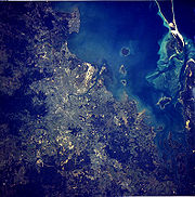
Brisbane
Brisbane is the capital and most populous city in the Australian state of Queensland and the third most populous city in Australia. Brisbane's metropolitan area has a population of over 2 million, and the South East Queensland urban conurbation, centred around Brisbane, encompasses a population of...
, Australia. The Brisbane metropolitan area, coincident with the Brisbane Statistical Division utilised by the Australian Bureau of Statistics
Australian Bureau of Statistics
The Australian Bureau of Statistics is Australia's national statistical agency. It was created as the Commonwealth Bureau of Census and Statistics on 8 December 1905, when the Census and Statistics Act 1905 was given Royal assent. It had its beginnings in section 51 of the Constitution of Australia...
, consists of the following local government areas (LGAs), with populations as of 2010:
- City of BrisbaneCity of BrisbaneThe City of Brisbane is the Local Government Area that has jurisdiction over the inner portion of the metropolitan area of Brisbane, Queensland, Australia...
(1,067,279) - City of IpswichCity of IpswichThe City of Ipswich is a Local Government Area in South East Queensland, covering an area of along the coast about southwest of Brisbane, the capital of Queensland. The City of Ipswich has a population of 162,380 .-History:...
(168,131) - Logan City (282,673)
- Moreton Bay Region (382,280)
- Redland City (142,822)
Inner suburbs
Bowen HillsBowen Hills, Queensland
Bowen Hills is an inner suburb of Brisbane, Australia, located 3 km northeast of the Brisbane CBD. It was named after a Governor of Queensland, Sir George Ferguson Bowen.-History:...
–
City
Brisbane central business district
The Brisbane central business district , sometimes referred to as the city, is a suburb of Brisbane, Queensland, Australia and is located on a point on the northern bank of the Brisbane River. The triangular shaped area is bounded by the Brisbane River to the east, south and west...
–
East Brisbane
East Brisbane, Queensland
East Brisbane is an inner suburb of Brisbane, Australia located 3 km east of the Brisbane CBD. It is predominantly residential, with some original "Queenslander" style homes, but with an increasing number of apartment blocks. Major roads include Lytton Road, Wellington Road and Latrobe...
–
Fortitude Valley –
Herston
Herston, Queensland
Herston is an inner suburb of Brisbane, Australia located 3 km north of the Brisbane CBD.- Geography :Herston is dominated by the Royal Brisbane and Women's Hospital...
–
Highgate Hill
Highgate Hill, Queensland
Highgate Hill is suburb of inner Brisbane, Australia and is located 2 km south of the Brisbane CBD on the Brisbane River. The topography of the suburb is undulating hills no more than above sea level....
–
Kangaroo Point
Kangaroo Point, Queensland
Kangaroo Point is a suburb of Brisbane, Queensland, Australia located directly east across the Brisbane River from the Brisbane central business district.- Geography :...
–
Kelvin Grove
Kelvin Grove, Queensland
Kelvin Grove is an inner northern suburb of Brisbane, Queensland, Australia located approximately 3 km from the CBD. This hilly suburb takes its name from Kelvingrove Park in Glasgow, Scotland. It is primarily residential with tree-lined streets and some commercial and light industrial...
–
New Farm
New Farm, Queensland
New Farm is an inner suburb of Brisbane, Australia, located 2 km east of the Brisbane CBD on a large bend of the Brisbane River. New Farm is partly surrounded by the Brisbane River, with land access from the north west through Fortitude Valley and from the north through...
–
Newstead
Newstead, Queensland
Newstead is a riverside suburb of the city of Brisbane, Queensland, Australia. It is situated 3 km north of the Brisbane central business district...
–
Petrie Terrace
Petrie Terrace, Queensland
Petrie Terrace is an inner-city suburb and major thoroughfare in Brisbane, Australia. It is located under 2 km to the west of the Brisbane General Post Office. The suburb is bordered to the west by Hale Street and to the east by Countess Street...
–
South Brisbane
South Brisbane, Queensland
South Brisbane is an inner city suburb of Brisbane, Australia located on the southern bank of the Brisbane River, directly connected to the central business district by the Kurilpa, Victoria and Goodwill bridges....
–
Spring Hill
Spring Hill, Queensland
Spring Hill is an inner suburb of Brisbane, Australia located 2 km north of the central business district. Parts of Spring Hill can be considered to be extensions of the Brisbane CBD.-Schools:Spring Hill is serviced by a number of schools...
–
Teneriffe
Teneriffe, Queensland
Teneriffe is an inner city suburb in Brisbane, Australia. Situated next to Teneriffe are the suburbs of Newstead, Fortitude Valley, Bowen Hills and New Farm...
–
West End
West End, Queensland
West End is an inner-city suburb of southern Brisbane.-History:West End was named by early English settlers who found the area reminiscent of the West End of London....
–
Woolloongabba
Woolloongabba, Queensland
Woolloongabba is an inner suburb of Brisbane, Australia located 4 km south of the Brisbane CBD.Experts are divided regarding the Aboriginal meaning of the name, preferring either 'whirling waters' or 'fight talk place'...
Northern suburbs
AlbionAlbion, Queensland
Albion is an inner north-eastern suburb of Brisbane, the state capital of Queensland, Australia.-Geography:Albion is bounded by Wooloowin in the north, Ascot in the east, Newstead in the south, and Windsor to the west, with Breakfast Creek defining the suburb border in its south and south-west...
–
Alderley
Alderley, Queensland
Alderley is a suburb of Brisbane, Queensland, Australia. It is north-west of the CBD. It is surrounded by Newmarket in the south, Ashgrove and Enoggera in the west, Grange and Stafford in the east and Kedron and Everton Park in the north. At the 2006 census, it had a populatio of 5,068.In...
–
Ascot
Ascot, Queensland
Ascot is a predominantly affluent residential suburb of Brisbane, Queensland, Australia, characterised by large Queenslander homes. Located from Brisbane, the suburb is well catered for in terms of public transport with many bus and train services departing from Ascot railway station...
–
Aspley
Aspley, Queensland
Aspley is a suburb of Brisbane, Queensland, Australia located about 13 kilometres north and about a half-hour drive north of the Central Business District of Brisbane...
–
Bald Hills
Bald Hills, Queensland
Bald Hills is the northernmost suburb of the Brisbane City Council in Queensland, Australia.Bald Hills is a largely residential suburb. It is mostly surrounded by bushland, but in the last few years some of the bush areas have been cleared to make way for new residential areas...
–
Banyo
Banyo, Queensland
Banyo is a northern suburb of Brisbane, Queensland. It is a community split between residential and industrial land usage, the latter being attracted by the accessibility of local transport, including the Gateway Motorway.-Description:...
–
Boondall –
Bracken Ridge
Bracken Ridge, Queensland
Bracken Ridge is a northern suburb of Brisbane, the capital city of Queensland, Australia. Its local government area is the City of Brisbane, in which it has its own ward.-Location:...
–
Bridgeman Downs
Bridgeman Downs, Queensland
Bridgeman Downs is a suburb located approximately north-west of Brisbane CBD.In November 1860 Henry St John Bridgeman bought land bounded by Albany Creek Road, Bridgeman Road and Beams Road....
–
Brighton
Brighton, Queensland
Brighton is the northernmost suburb of Brisbane City, Australia, located 19 km north of the Brisbane CBD. The Nashville locality makes up much of the southwest of the suburb.Brighton features mostly suburban housing...
–
Brisbane Airport –
Carseldine
Carseldine, Queensland
Carseldine is a suburb of Brisbane, Queensland, Australia located about north and about a half-hour drive from the Central Business District of Brisbane. It is surrounded by Bald Hills and Bracken Ridge to the North, Aspley to the South, Fitzgibbon to the East and Bridgeman Downs to the...
–
Chermside
Chermside, Queensland
Chermside is a suburb on the north side of Brisbane, Queensland, Australia.Chermside is a key destination along Queensland Transport's future Northern Busway...
–
Chermside West
Chermside West, Queensland
Chermside West is a suburb of Brisbane, Australia. It is located approximately 10 km north of the Brisbane central business district. It is located within the Brisbane City Council local government area.-External links:*...
–
Clayfield
Clayfield, Queensland
Clayfield is an inner-northern suburb of Brisbane, located approximately from the CBD. Clayfield is bordered to the north by Nundah, to the East by Ascot and Hendra, to the west by Wooloowin and to the South by Albion....
–
Deagon
Deagon, Queensland
Deagon is an outer suburb of Brisbane, Australia. It is 16 km north of the CBD.Deagon was named after William Deagon who was Mayor of Sandgate in 1882, 1883 and 1884....
–
Eagle Farm
Eagle Farm, Queensland
Eagle Farm is a largely industrial suburb of Brisbane in Queensland, Australia, situated around six kilometres from the Brisbane central business district. It is the former site of Eagle Farm Airport, Brisbane's main airport until the opening of the Brisbane Airport. Eagle Farm was also the site of...
–
Everton Park
Everton Park, Queensland
Everton Park is a suburb of Brisbane, Queensland, Australia.It is about eight kilometres north of the Brisbane CBD. The area is mainly residential, with a population of about 8000....
–
Fitzgibbon
Fitzgibbon, Queensland
Fitzgibbon is a suburb north of the Brisbane central business district in Queensland, Australia. The suburb is one of the smallest suburbs in Brisbane and was named after Abram Fitzgibbon, who was chief engineer of railways in Queensland in the 1860s. The suburb is roughly triangular in shape,...
–
Gaythorne
Gaythorne, Queensland
Gaythorne is a suburb of Brisbane, Queensland, Australia. It is located seven kilometres north-west of the Brisbane central business district. Gaythorne is situated on the slopes of Enoggera Hill. It shares some streets with the neighbouring suburb of Mitchelton. In the late 1990s it was split from...
–
Geebung
Geebung, Queensland
Geebung is a suburb of northern Brisbane, Australia. It is centred around its railway station on the Caboolture railway line. The suburb is named after the Geebung tree of the genus Persoonia which was previously known as the Geebong...
–
Gordon Park
Gordon Park, Queensland
Gordon Park is a small residential area in the middle of Brisbane's northern suburbs and the smallest suburb within Brisbane City Council. Without any major shopping centres or business, it seems like a small town instead of being close to the centre of a major city.-Profile:Gordon Park is about...
–
Grange
Grange, Queensland
Grange is an inner-northern suburb of Brisbane, capital of the Australian state of Queensland. It is located north of the central business district, on the southern side of Kedron Brook. In 2001, the population of Grange stood at 3,941....
–
Hamilton
Hamilton, Queensland
Hamilton is an inner northern suburb of Brisbane, Australia, lying on the north bank of the Brisbane River along Bulimba Reach. The area is hilly with views of the Brisbane central business district....
–
Hendra
Hendra, Queensland
Hendra is a suburb of the city of Brisbane, Queensland, Australia. It lies roughly six kilometres north-east of Brisbane central business district.- History :...
–
Kedron
Kedron, Queensland
Kedron is a northern suburb of Brisbane, Australia, centred on Gympie Road and Kedron Brook. It is close to Westfield Chermside shopping centre in the neighbouring suburb of Chermside...
–
Keperra
Keperra, Queensland
Keperra is a suburb in Brisbane, Queensland, Australia which is located approximately 9 kilometres north-west of the CBD. It has a deep and rich history, with some thinking that the name was based upon the Aboriginal term for “Kipper”...
–
Lutwyche
Lutwyche, Queensland
Lutwyche is an inner-city residential suburb of Brisbane, located 5 km north of the city's central business district. The suburb is named after Alfred Lutwyche, a judge of the Supreme Court of New South Wales who was appointed as Supreme Court judge at Moreton Bay on 21 February 1859 , shortly...
–
McDowall
McDowall, Queensland
McDowall is a northern suburb within the city of Brisbane, the capital city of Queensland, Australia.McDowall is notable for the Raven Street Reserve, which is a 24.3 hectare bushland area surrounded by urban housing and busy roads...
–
Mitchelton
Mitchelton, Queensland
Michelton is a suburb of Brisbane, in Queensland, Australia. The suburb is located 8 kilometres from the Brisbane central business district some areas of Mitchelton can be 6 km to the Brisbane central business district....
–
Myrtletown
Myrtletown, Queensland
Myrtletown is a suburb within the city of Brisbane, in Queensland, Australia. East of Pinkenba, it is situated near the northern bank of the mouth of the Brisbane River. Formerly a semi-rural residential area, the construction of the Brisbane Airport at nearby Cribb Island caused most residents...
–
Newmarket
Newmarket, Queensland
Newmarket is an inner north-western suburb of Brisbane, Queensland, Australia. It is located approximately 5 km from the Brisbane central business district and is surrounded by the suburbs of Alderley to the north, Ashgrove to the west, Kelvin Grove to the south, and Wilston to the east...
–
Northgate
Northgate, Queensland
Northgate is a suburb of Brisbane, Australia located 9 km north of the Brisbane CBD. The land area comprises industrial and residential areas...
–
Nudgee
Nudgee, Queensland
Nudgee is a suburb of Brisbane, Australia. It is north of the CBD.Nudgee was part of the Toombul Shire Council until 1925 when it was absorbed by the Brisbane City Council....
–
Nudgee Beach
Nudgee Beach, Queensland
Nudgee Beach is an outer suburb of Brisbane, Australia and also the name of the Beach located in the suburb. It is north of the Brisbane central business district where Shultz Canal enters Moreton Bay...
–
Nundah
Nundah, Queensland
Nundah is an inner suburb in the city of Brisbane, Australia, located approximately 8 kilometers north-east of the Brisbane central business district, in the local government area of the City of Brisbane....
–
Pinkenba
Pinkenba, Queensland
Pinkenba is the name of a suburb in eastern Brisbane on the northern side of the Brisbane River. Despite being less than 10 kilometres from the Brisbane central business district, it has a largely rural feel to it...
–
Sandgate
Sandgate, Queensland
Sandgate is a coastal suburb in Brisbane, Australia, located 16 km north of the Brisbane CBD. The town became a popular escape for the people of Brisbane in the early 20th century.-Geography:Sandgate is situated on the coastline, along Bramble Bay...
–
Shorncliffe
Shorncliffe, Queensland
Shorncliffe is a suburb of Brisbane, Australia. It is situated northeast of Brisbane and is the neighbouring suburb of Sandgate. The suburb comes under the jurisdiction of the Brisbane City Council.It is a small community with a village atmosphere...
–
Stafford
Stafford, Queensland
Stafford is a northern suburb of Brisbane, the state capital of Queensland, Australia.A predominantly residential suburb, including some original Queenslander-style homes and a significant number of post-war Queensland Housing Commission homes on quarter-acre blocks built around the 1940s and...
–
Stafford Heights
Stafford Heights, Queensland
Stafford Heights is a suburb of Brisbane, Australia. It is 8 km north of the Brisbane central business district and is named after its neighbour Stafford.-External links:* *...
–
Taigum
Taigum, Queensland
Taigum is a northern suburb of Brisbane in Queensland in Australia. It is about 13 kilometres north of the Brisbane central business district|CBD. It is predominantly a residential area...
–
Virginia
Virginia, Queensland
Virginia is a suburb in Brisbane, Queensland, Australia. It is located 10 km north of the Brisbane central business district. It is primarily a residential suburb with many timber and tin Queenslander style housing...
–
Wavell Heights
Wavell Heights, Queensland
Wavell Heights is a Brisbane suburb located 9 km north of the Brisbane central business district. It is named after Field Marshal Lord Wavell who was the Commander-In-Chief of the Allied Forces in the Middle East during the Second World War....
–
Wilston
Wilston, Queensland
Wilston, a suburb of Brisbane, Queensland, Australia, is located approximately three kilometres from the Brisbane central business district, and is a mixture of old and the new styles of architecture, from workers' cottages to modern architect-designed homes on Wilston Hill.Wilston is home to many...
–
Windsor
Windsor, Queensland
Windsor is an inner northern suburb of Brisbane, located about 3.5 km from the CBD. It is largely residential, featuring many old Queenslanders, although there is also considerable retail commercial activity, primarily concentrated along Lutwyche and Newmarket Roads.-History:Land was first...
–
Wooloowin
Wooloowin, Queensland
Wooloowin is an inner-north suburb of Brisbane, Australia located approximately 5-6 km north of the city's central business district. The suburb derives its name from a local Indigenous Australian term for "pigeon"...
–
Zillmere
Zillmere, Queensland
Zillmere is a suburb 14 km north of the Brisbane central business district in Queensland, Australia.-History:The Turrbal Aborigines occupied the region north of Brisbane River, including the area covered by Zillmere....
Southern suburbs
Acacia RidgeAcacia Ridge, Queensland
Acacia Ridge is a suburb of Brisbane, Queensland, Australia. Acacia Ridge is south of the central business district. The population in the 2001 census was 6648....
–
Algester
Algester, Queensland
Algester is an outer suburb of Brisbane, Queensland, Australia. It is south-west of the central business district.Algester was heavily developed after the Second World War and has also seen considerable recent development. It forms part of the Brisbane Agricultural Reserve, which once covered a...
–
Annerley
Annerley, Queensland
Annerley is a suburb of Brisbane, Australia located 6 km south of the Brisbane CBD. It was named after a town in England.-Geography:Much of the suburb is elevated, lying on a ridge that gives views of the city...
–
Archerfield
Archerfield, Queensland
Archerfield is an outer suburb of Brisbane, Australia. Archerfield is a sparsely populated suburb, with most of the land being occupied by Archerfield Airport.-Airport:...
–
Berrinba
Berrinba, Queensland
Berrinba is a suburb in the Brisbane metropolitan area in Queensland, Australia. It is split between the Brisbane and Logan City local government areas....
–
Burbank
Burbank, Queensland
Burbank is a large, greenbelt suburb in south east Brisbane, Queensland, Australia. The suburb was named after Frank Burbank, a local horse dealer. Mount Petrie lies just to the north of the suburb. Burbank has a number of small intermittent creeks winding between cleared and uncleared rolling...
–
Calamvale
Calamvale, Queensland
Calamvale is a suburb on the south side of the city of Brisbane, Australia. A relatively large suburb, it adjoins Stretton, Parkinson, Sunnybank Hills, Acacia Ridge, Algester and Drewvale. It is 18 kilometres from Brisbane's central business district....
–
Carole Park
Carole Park, Queensland
Carole Park is a suburb of Brisbane, Australia. It is south-west of the CBD of Brisbane.Carole Park is half residential, half industrial, with the Logan Motorway separating the two areas...
–
Coopers Plains
Coopers Plains, Queensland
Coopers Plains is an outer suburb of Brisbane, Australia. It is south-west of the CBD.-Transport:Coopers Plains railway station provides access to regular Citytrain services to Brisbane, Beenleigh and Gold Coast. There are many buses passing Coopers Plains, which are 120 , 135 , 123 , 598 and 599...
–
Darra
Darra, Queensland
Darra is a Brisbane suburb known for its high migrant population. It is one of the older suburbs and lies about 14 kilometres southwest of Brisbane. The houses are mainly of the Queenslander style built in the 1940s and 1950s. The majority of blocks in Darra are large enough to be subdivided, which...
–
Doolandella
Doolandella, Queensland
Doolandella is an outer suburb of Brisbane, Australia. It is south-west of the CBD.Doolandella, or Dulandella, is the Aboriginal name for the geebung tree and its fruit....
–
Drewvale
Drewvale, Queensland
Drewvale is an outer suburb of Brisbane, Australia. It is south of the CBD and borders with Logan City. Drewvale is located at the interchange of the Gateway and Logan Motorways. It is the most southern suburb of Brisbane.-External links:* *...
–
Durack
Durack, Queensland
Durack is an outer suburb of Brisbane, Australia. It is south-west of the CBD.Durack is named after Michael Durack, one of the original landholders of the area.-External links:* *...
–
Dutton Park
Dutton Park, Queensland
Dutton Park is a suburb of Brisbane, Australia located 5 km south of the Brisbane CBD. The suburb is predominantly residential, with some light industrial and commercial areas....
–
Eight Mile Plains
Eight Mile Plains, Queensland
Eight Mile Plains is a southern suburb of Brisbane, Queensland, Australia. It is located some 13 kilometres from the Brisbane central business district....
–
Ellen Grove
Ellen Grove, Queensland
Ellen Grove is an outer suburb of Brisbane, Australia and is located south-west of the Brisbane CBD.Ellen Grove was subdivided for housing around 1959, with the name of the suburb Gazetted in 1962 due to lobbying from the Ellen Grove Progress Association....
–
Fairfield
Fairfield, Queensland
Fairfield is a suburb of Brisbane, Australia located 5 km south of the Brisbane CBD on the Brisbane River. The suburb is mainly residential with house and unit accommodation.-Geography:...
–
Forest Lake
Forest Lake, Queensland
Forest Lake or "The Living Forest" as it is affectionately known, was the first Master Planned Community within the municipality of Brisbane, Queensland. It has won numerous awards for its design and had a population of 20,900 residents, as of February 2006. Delfin, the developer of Forest Lake,...
–
Greenslopes
Greenslopes, Queensland
Greenslopes is a moderately sized suburb of the city of Brisbane, state capital of Queensland, Australia."Greenslopes" is also the name of a Queensland state electorate. The electorate contains only a small fraction of the suburb of the same name...
–
Heathwood
Heathwood, Queensland
Heathwood is an outer suburb of Brisbane, Australia. It is 21 km south of the CBD.Heathwood was named after an early settler in the district.-External links:* *...
–
Holland Park
Holland Park, Queensland
Holland Park is a suburb of Brisbane, the capital city of Queensland, Australia, that is situated approximately 8 km south of the Brisbane central business district. Holland Park is an older suburb made of largely post-World War II wooden homes. In fact over 89% of dwellings are houses.Logan...
–
Holland Park West
Holland Park West, Queensland
Holland Park West is a suburb of Brisbane, Queensland, Australia. The suburb was gazetted in 1972.It is located in the inner suburbs south-east of the Brisbane central business district between the Pacific Motorway and Logan Road.-References:...
–
Inala
Inala, Queensland
Inala is a suburb of Brisbane, Australia, situated in the south-west of the metropolitan area.-History:Following World War II there was a shortage of 250,000 houses across Australia. State and Commonwealth Governments responded by making housing a priority. In Queensland alone over 4000 families...
–
Karawatha
Karawatha, Queensland
Karawatha is an outer suburb of Brisbane, Australia. It is 22 km south-east of the CBD.The naming of the suburb Karawatha originates from an Aboriginal word meaning a place with pine trees...
–
Kuraby
Kuraby, Queensland
Kuraby is a suburb of Brisbane, Queensland, Australia. It is situated approximately by road or by rail south-east of the city of Brisbane.Beenleigh Road is the main road connecting the suburb to the motorways leading to the city and further parts of Brisbane and beyond.Kuraby is serviced by fast...
–
Larapinta
Larapinta, Queensland
Larapinta is a suburb located in the southern regions of Brisbane, on the edge of the Logan shire. The suburb is sparsely populated, being mostly bushland, save for the recent construction of industry. The industrial area has become a new addition to the expansion of Brisbane's industry, including...
–
Macgregor
Macgregor, Queensland
Macgregor is a suburb in Brisbane, Queensland, Australia. Its postal code is 4109. It is in the Australian Federal electorate of Moreton and its current member is the Honourable Mr Graham Perrett MP. Most of Macgregor is in the Queensland state electorate of Sunnybank, with only the northern tip...
–
Mackenzie
Mackenzie, Queensland
Mackenzie is a small suburb located in the south-east of Brisbane, Queensland, Australia. This is an "out-back" suburb containing no large or small shopping centres. The area is partially covered by undeveloped bushland. Mount Petrie is located in Mackenzie....
–
Mansfield
Mansfield, Queensland
Mansfield is a suburb of Brisbane, Australia, situated approximately 11 kilometres south-east of the CBD. It is located in the region of the city which is now colloquially known as the "Bible Belt" due to the large number of people who have settled there to be close to Fundamentalist Christian...
–
Moorooka
Moorooka, Queensland
Moorooka is a suburb of Brisbane, the state capital of Queensland, Australia. Bordering with Toohey Forest Park, it is seven kilometres south of Brisbane's central business district...
–
Mount Gravatt
Mount Gravatt, Queensland
Mount Gravatt is the name of both a major suburb of Brisbane, Queensland, Australia and a prominent hill in this suburb. The suburb is situated in the south-east of the city and was one of Brisbane's largest...
–
Mount Gravatt East
Mount Gravatt East, Queensland
Mount Gravatt East is a suburb of Brisbane, Australia, located southeast of the central business district.Named after Mount Gravatt, a nearby landmark, the suburb was first gazetted in 1967....
–
Nathan
Nathan, Queensland
Nathan is a southern suburb of Brisbane, Australia. It was named in 1967 after Sir Matthew Nathan, Governor of Queensland from 1920 to 1926.Nathan is home to Toohey Forest Conservation Park, Griffith University's Nathan campus and the Queensland Sport and Athletics Centre which hosted the opening...
–
Oxley
Oxley, Queensland
Oxley is a south-western suburb of Brisbane located approximately 11 km from the Brisbane CBD. It was named after the early Australian explorer John Oxley. The suburb supports a mix of residential, retail and industrial land use....
–
Pallara
Pallara, Queensland
-External links:* *...
–
Parkinson
Parkinson, Queensland
Parkinson is an outer southern suburb of Brisbane, Australia. It is 19 km south of the CBD and borders Logan City.Parkinson is sparsely populated with mainly rural land use. It is in the Electoral district of Algester.-External links:* *...
–
Richlands
Richlands, Queensland
Richlands is an outer suburb of Brisbane, Australia. It is 16 km south-west of the CBD.-External links:* *...
–
Robertson
Robertson, Queensland
Robertson is an outer suburb in the south of Brisbane, Australia. It is south of the CBD.. It was officially named in July 1967 in memory of Doctor William Nathaniel Robertson who was a member of the University of Queensland Senate. It is one of several suburbs near the University of...
–
Rochedale
Rochedale, Queensland
Rochedale is an outer suburb of the city of Brisbane, Australia. It is south-east of the Brisbane central business district.- History :During convict settlement, explorers passed through the region but it was not until 1865 that the first settlers started farming the area's rich alluvial soil.The...
–
Rocklea
Rocklea, Queensland
The large Brisbane suburb of Rocklea is located 12 kilometres south of the city. At times the suburb has experienced significant flooding from the nearby Brisbane River. The west of the suburb is bordered by the Oxley Creek....
–
Runcorn
Runcorn, Queensland
Runcorn is a suburb on the south side of Brisbane, Queensland, and is about from Brisbane’s central business district. The Jagera Aboriginal people occupied most of the land south of the Brisbane River and Runcorn would have been in the territory of the Chepara clan of Eight Mile Plains, Queensland...
–
Salisbury
Salisbury, Queensland
Salisbury is a suburb of Brisbane, Australia. It is south of the Brisbane central business district.Salisbury was named after the residence of William Coote, an early Brisbane journalist and political figure, who lived in the area....
–
Seventeen Mile Rocks
Seventeen Mile Rocks, Queensland
Seventeen Mile Rocks is a suburb of Brisbane, Australia located south-west of the Brisbane CBD on the Brisbane River.Seventeen Mile Rocks is named after a collection of rocks that marked a distance of from the mouth of the Brisbane River...
–
Sinnamon Park
Sinnamon Park, Queensland
Sinnamon Park is a suburb of Brisbane, Australia located 14 km south-west of the Brisbane CBD. Sinnamon Park is named for the pioneering Sinnamon Family...
–
Stretton
Stretton, Queensland
Stretton is a suburb on the south side of Brisbane, Australia. It is 17 kilometres from the Brisbane Central Business District, and borders the suburbs of Calamvale, Sunnybank Hills, Karawatha, Kuraby, and Drewvale.- History :...
–
Sumner
Sumner, Queensland
Sumner is an outer suburb of Brisbane, Australia. It is 15 km south-west of the CBD.Sumner is split between residential and industry, with a large industrial estate Sumner Park.-External links:*...
–
Sunnybank
Sunnybank, Queensland
Sunnybank is now a suburb in Brisbane, Queensland, Australia much reduced in size from the previous suburb of Sunnybank. The separate Town of Sunnybank was absorbed into the City of Brisbane. This older Sunnybank area is still known locally as Sunnybank...
–
Sunnybank Hills
Sunnybank Hills, Queensland
Sunnybank Hills is an outer southern suburb of Brisbane about 15 kilometres from Brisbane CBD, in Queensland, Australia. It is a large suburb, and adjoins the suburbs of Calamvale, Coopers Plains, Sunnybank, Macgregor, Algester, Acacia Ridge and Runcorn....
–
Tarragindi
Tarragindi, Queensland
Tarragindi is a suburb on the southern side of Brisbane, Queensland, Australia. It is represented through the Holland Park and Moorooka Ward councillors on the Brisbane City Council.-Origin of the name:...
–
Tennyson
Tennyson, Queensland
Tennyson is a suburb of Brisbane, Australia. It is 7 km south of the CBD on the Brisbane River.The area was originally named Softstone by James Strong, one of the original settlers, but by 1897 the name was changed to Tennyson. Tennyson is named after the British poet Alfred Tennyson.The...
–
Upper Mount Gravatt
Upper Mount Gravatt, Queensland
Upper Mount Gravatt is a suburb in Brisbane, to the south of Mount Gravatt. It has increasingly become an important centre in the last 15 years...
–
Wacol
Wacol, Queensland
Wacol is a suburb of Brisbane, Australia. According to the 2001 census, a total of 4851 people lived within the boundaries of Wacol. The suburb is located on the east bank of the Brisbane River, 18 km south-west of the Brisbane central business district, on the Brisbane-Ipswich railway...
–
Willawong
Willawong, Queensland
Willawong is an outer suburb of Brisbane, Australia. It is 16 km south of the CBD.Willawong is an Aboriginal meaning ‘the junction of two creeks’.This suburb has one of the Brisbane Transport bus depots located within the suburb.-External links:*...
–
Wishart
Wishart, Queensland
Wishart is a suburb of Brisbane, Australia. It is 14 km south-east of the CBD.The Brisbane Adventist College, Mansfield State High School and Primary Schools are located near to Wishart. Bulimba Creek flows through the suburb....
–
Yeerongpilly
Yeerongpilly, Queensland
Yeerongpilly is a suburb of in Brisbane, Australia. It is 8 km south of the Brisbane central business district.Yeerongpilly is derived from the Aboriginal words "yarung" meaning sandy or gravelly or "yurong" meaning rain and "pilly" meaning gully or watercourse.Yeerongpilly grew from an area...
–
Yeronga
Yeronga, Queensland
Yeronga is a suburb of Brisbane, Australia located on the Brisbane River 7 km south of the Brisbane CBD. Yeronga is a residential suburb. It is home to the Yeronga Devils.-Transport:There is a Yeronga train station on the Beenleigh railway line....
Eastern suburbs
BalmoralBalmoral, Queensland
Balmoral is an inner suburb of Brisbane, Australia, located 9 kilometres east of the CBD.Balmoral is an anglicisation of Baile Mhoireil which is Scottish Gaelic for ‘beautiful residence’ or ‘majestic castle’....
–
Belmont
Belmont, Queensland
Belmont is an outer suburb of Brisbane, Australia. It is 12 km south-east of the CBD.Belmont is named after the original estate in 1876, the estate grew and became the Belmont Shire in 1901...
–
Bulimba
Bulimba, Queensland
Bulimba is an inner suburb of Brisbane, Australia. It is 4 kilometres south-east of the CBD, and is located on the southern bank of the Brisbane River...
–
Camp Hill
Camp Hill, Queensland
Camp Hill is a largely residential suburb in the south-east of Brisbane, Queensland, Australia. It is located approximately 4 km from the Brisbane central business district and, as its name suggests, is elevated and commands fine views of the CBD. It has an area of 4.6 square...
–
Cannon Hill
Cannon Hill, Queensland
Cannon Hill is an inner suburb of Brisbane, Australia. It is east of the CBD.Cannon Hill was named after the Weedon family home 'Cannon Hill House'. Built in 1867, the house, which had extensive grounds and a maze, burnt down in 1927.-Transport:...
–
Capalaba West
Capalaba West, Queensland
Capalaba West was an outer suburb of Brisbane, Australia. It is east of the CBD.The Capalaba region was initially settled in 1859 when the Queensland Government offered incentives to encourage immigration....
–
Carina
Carina, Queensland
Carina is an eastern suburb of Brisbane, Queensland, Australia about 7 kilometres from the Central Business District. It adjoins the suburbs of Carindale, Carina Heights, Cannon Hill and Camp Hill....
–
Carina Heights
Carina Heights, Queensland
Carina Heights is a suburb of Brisbane, Australia. It is south-east of the CBD. Surrounding suburbs include Camp Hill, Holland Park, Mount Gravatt East, Carina and Carindale.Carina Heights is named after the neighbouring suburb Carina.-External links:**...
–
Carindale
Carindale, Queensland
Carindale is a suburb of the city of Brisbane, which has a population of approximately 15,135 people and contains around 4,976 dwellings. The greater area was formerly known as Belmont....
–
Chandler
Chandler, Queensland
Chandler is an outer suburb of Brisbane, Australia south-east of the CBD.Chandler was named after Sir John Beals Chandler and is a semi-rural suburb and not yet heavily developed or subdivided.-External links:** *...
–
Coorparoo
Coorparoo, Queensland
Coorparoo is a southern suburb of Brisbane, Queensland, Australia, located approximately four kilometres from the city. Surrounding suburbs include Camp Hill, Holland Park, Greenslopes, East Brisbane, Norman Park and Seven Hills.-Aboriginal history:...
–
Gumdale
Gumdale, Queensland
Gumdale is an outer suburb of Brisbane, Australia. It is 14 km east of the CBD.The average property size in Gumdale is approximately between 5000m2 - 10 000m2 making Gumdale consist mostly of acreages. However, access to Brisbane city is only 15 to 20 minutes away by car...
–
Hawthorne
Hawthorne, Queensland
Hawthorne is an inner riverside suburb of Brisbane, Australia. It is east of the Brisbane central business district.Hawthorne started as a farming district in the 1860s, and was gradually subdivided as Brisbane grew...
–
Hemmant
Hemmant, Queensland
Hemmant is a suburb of Brisbane, Australia. It is 11 km east of the CBD located on the Brisbane River.Hemmant was originally known as "Doughboy Creek"-Transport:Hemmant railway station provides access to regular Citytrain services to Brisbane and Cleveland....
–
Lota
Lota, Queensland
Lota is an outer suburb of Brisbane, Australia. It is 17 km east of the CBD.Most of the land of Lota was originally owned by William Duckett White, who settled in 1862...
–
Lytton
Lytton, Queensland
Lytton is an outer suburb of Brisbane, Australia. It is 15 km north-east of the CBD.Although Lytton was once a town, it is now primarily commercial and industrial. It shares the same postcode as the Port of Brisbane....
–
Manly
Manly, Queensland
Manly is a suburb of Brisbane, Australia. It is located approximately 16km east of Brisbane CBD. Surrounding suburbs are Wynnum , Lota to the South and Manly West . To the east lies Moreton Bay.-History:...
–
Manly West
Manly West, Queensland
Manly West is a suburb of Brisbane, Australia. It is 16 km east of the CBD. Manly West contains a primary school, a preschool, Moreton Bay College and Moreton Bay Boys College. Over 47% of households in this area consist of a couple with children and a further 35% are couples without children...
–
Moreton Island
Moreton Island
Moreton Island is a large sand island on the eastern side of Moreton Bay, on the coast of south-east Queensland, Australia. Moreton Island lies 58 kilometres northeast of the Queensland capital, Brisbane. The island is 95% National Park and a popular destination for four wheel driving, camping,...
–
Morningside
Morningside, Queensland
Morningside is a suburb in the south-east of Brisbane, Australia, surrounded by Cannon Hill, Norman Park and Hawthorne. Morningside's postal code is 4170. The old suburb of Colmslie was merged into Morningside....
–
Murarrie
Murarrie, Queensland
Murarrie is a suburb of Brisbane, Australia. It is located in the eastern suburbs on the southern bank of the Brisbane River adjacent to the Gateway Bridge.Murarrie has both residential and industrial sections...
–
Norman Park
Norman Park, Queensland
Norman Park is a suburb in Brisbane, Australia. It is located 4 km east of the Brisbane central business district.Norman Park has numerous parks and recreational areas for residents in the area...
–
Port of Brisbane
Port of Brisbane
Port of Brisbane is the shipping port of Brisbane, on the east coast of Australia. It is located in the lower reaches of the Brisbane River on reclaimed land that was once called Fisherman Islands at the mouth of the river. It currently is the third busiest port in Australia and the nation's...
–
Ransome
Ransome, Queensland
Ransome is an outer suburb of Brisbane, Australia. It is east of the CBD.Ransome was named after C.H. Ransome who lived in the area and set up a business supplying mixed firewood to the city.-External links:*...
–
Seven Hills
Seven Hills, Queensland
Seven Hills is a suburb located on the inner eastern side of Brisbane, surrounded by the suburbs of Norman Park, Morningside and Carina.Between 1912 and 1926 the southern edge of the suburb was serviced by a steam tram which connected with the Queensland Government Railway at Norman Park. ...
–
Tingalpa
Tingalpa, Queensland
Tingalpa is located near Manly West and Belmont, Queensland in the Eastern suburbs of Brisbane, Australia. It is located east of the Brisbane CBD....
–
Wakerley
Wakerley, Queensland
Wakerley is an outer suburb of Brisbane, Australia. It is 15 km east of the CBD.Wakerley was named after an early settler J W Wakerley.-External links:* *...
–
Wynnum
Wynnum, Queensland
Wynnum is a suburb located on the shores of Moreton Bay in Brisbane, Australia, about 16 kilometres east of the CBD. The area was sparsely settled until the arrival of the railway in the late 1880s, but then grew fairly rapidly. The former Wynnum Shire Council was created in 1902, and twelve years...
–
Wynnum West
Wynnum West, Queensland
Wynnum West is an outer suburb of Brisbane, Australia located 16 km east of the CBD. Originally part of surrounding suburbs, Wynnum West was gazetted in 1975 as a separate suburb....
Western suburbs
AnsteadAnstead, Queensland
Anstead is an outer suburb of Brisbane, Australia located south-west of the Brisbane CBD. Anstead is located on the northern bank of the Brisbane River....
–
Ashgrove
Ashgrove, Queensland
Ashgrove is an inner suburb of Brisbane in Queensland, Australia, located approximately 4 km north-west of the Brisbane CBD. Ashgrove is a leafy residential suburb, characterised by its hilly terrain and characteristic Ashgrovian houses built in the early 20th century...
–
Auchenflower
Auchenflower, Queensland
Auchenflower is an inner suburb of Brisbane, Queensland, Australia located 2.5 km west of the Brisbane CBD bordering the Brisbane River.-History:Between 1900 and 1962 Auchenflower was served by trams running along Milton Road from Toowong...
–
Bardon
Bardon, Queensland
Bardon is an inner suburb of Brisbane, Australia located approximately 5 km west of the Brisbane CBD. Bardon is a leafy residential suburb, much of which nestles into the foothills of Mount Coot-tha.-History:...
–
Bellbowrie
Bellbowrie, Queensland
Bellbowrie is a suburb of Brisbane, Queensland, Australia. Bellbowrie lies 17 kilometres west-southwest of Brisbane's city centre. It is a rapidly developing semi-rural area due to Brisbane's growth heading in a westwards direction....
–
Brookfield
Brookfield, Queensland
Brookfield is a suburb of Brisbane, Australia located approximately 13 km to the west of the Brisbane CBD. Brookfield was named by Mrs J. S. Brimblecombe due to the creeks and gullies in the area.-Geography:...
–
Chapel Hill
Chapel Hill, Queensland
Chapel Hill is a suburb of Brisbane, Australia which is located 7 km south-west of the Brisbane CBD. It is primarily a residential suburb, consisting of mostly detached housing. There has been a trend towards townhouse and small lot developments during the last decade...
–
Chelmer
Chelmer, Queensland
Chelmer is an inner suburb of Brisbane, Australia located 7 km west of the Brisbane CBD on the Brisbane River. Chelmer is zoned as a residential area, and consists of low-density housing. It has many fine Queenslanders, characterised by wooden verandahs, wide stairways and roofing of...
–
Chuwar
Chuwar, Queensland
Chuwar is a suburb of both Ipswich, Australia and Brisbane in South East Queensland, Australia. It is north of the Ipswich central business district, west of Brisbane by road....
–
Corinda
Corinda, Queensland
Corinda is a suburb in Brisbane, Australia. Located approximately 9 km southwest of the Brisbane central business district.It is believed that the name Corinda originates from a local cattle station owned by Sir Arthur Palmer, which he named after his Corinda pastoral station near...
–
Enoggera
Enoggera, Queensland
Enoggera is a suburb of Brisbane, in Queensland, Australia. The suburb is located 6 km north-west of the Brisbane CBD.-History:In 1845 John Brennan purchased six hectares of land in Enoggera. Six years later, Thomas Hayes moved to the area and bought thirty-three acres of land...
–
Enoggera Reservoir
Enoggera Reservoir, Queensland
Enoggera Reservoir is an outer suburb of Brisbane, Australia located north-west of the CBD and bordering the Moreton Bay Region and The Gap. It contains Peewee Bend....
–
Ferny Grove
Ferny Grove, Queensland
Ferny Grove is a residential suburb in north-west Brisbane, Queensland, Australia. It lies entirely within the Brisbane-metropolitan area administered by the Brisbane City Council.-General information:...
–
Fig Tree Pocket
Fig Tree Pocket, Queensland
Fig Tree Pocket is a suburb of Brisbane, Australia located 8 km south-west of the Brisbane CBD on the Brisbane River. Placed within a pocket of the Brisbane River, the suburb is relatively remote, devoted mostly to low density housing...
–
Graceville
Graceville, Queensland
Graceville is a suburb in Brisbane, Queensland, Australia. It is located 8 km south-west of the Brisbane CBD. Graceville is bordered by the Brisbane River to the North-East and West, Oxley Creek to the East, Chelmer to the North and Sherwood to the South....
–
Indooroopilly
Indooroopilly, Queensland
Indooroopilly is a suburb of Brisbane, Australia which is located 7 km west of the Brisbane central business district.- Name derivation and history :...
–
Jamboree Heights
Jamboree Heights, Queensland
Jamboree Heights is a suburb of Brisbane, Australia. It is south west of the CBD.Jamboree Heights was part of the 'Centenary Project', and along with surrounding suburbs was developed in 1959...
–
Jindalee
Jindalee, Queensland
Jindalee is an outer suburb of Brisbane, Australia located south-west of the Brisbane CBD, and is a part of the Centenary suburbs. It is bordered by the Brisbane River to the north. The Aboriginal meaning for Jindalee is "bare hills"...
–
Karana Downs
Karana Downs, Queensland
Karana Downs is a suburb of Brisbane's west in south-east Queensland, Australia, 22 km from Brisbane's CBD.The semi-rural, leafy suburb is bordered by the Brisbane River to the south and east, and Mount Crosby to the west....
–
Kenmore
Kenmore, Queensland
Kenmore is a suburb of Brisbane, Australia located 10 km south-west of the Brisbane CBD. Kenmore is a leafy suburb with a high number of professional residents and families. It is dominated by detached housing - units and townhouses are rare...
–
Kenmore Hills
Kenmore Hills, Queensland
Kenmore Hills is a suburb of Brisbane, Australia approximately 10 km south-west of the CBD.Kenmore Hills originally formed part of Brookfield, but in 1975 the name was changed to Kenmore Hills, based on the nearby suburb of Kenmore.-External links:*...
–
Kholo
Kholo, Queensland
Kholo is an outer suburb of Brisbane, Australia located 22 km south-west of the Brisbane CBD. Kholo became part of the Brisbane City in 1999.-External links:* *...
–
Lake Manchester
Lake Manchester, Queensland
Lake Manchester is an outer suburb of Brisbane, Australia. It is west of the CBD next to Brisbane Forest. The suburb Lake Manchester is named after the Lake Manchester Dam constructed between 1912–1916.-External links:* *...
–
Middle Park
Middle Park, Queensland
Middle Park is a predominantly residential suburb located 14 km south-west of the CBD of Brisbane, Queensland, Australia.Many properties on Sumners Road have an address in Middle Park but are not themselves actually in Middle Park and are disregarded in this article.-Geography:Middle Park is...
–
Milton
Milton, Queensland
Milton is an inner suburb of Brisbane, Australia, located approximately west of Brisbane's central business district. The suburb is a mixture of light industry, warehouses, commercial offices, retail and single and multiple occupancy residences...
–
Moggill
Moggill, Queensland
Moggill is one of Brisbane's western suburbs, about from the CBD. It comprises a mixture of small-lot and acreage residential homes along with a small number of remaining farms...
–
Mount Coot-tha –
Mount Crosby
Mount Crosby, Queensland
Mount Crosby is a mountain and outer suburb of Brisbane, Australia located south-west of the Brisbane CBD.-Geography:The Brisbane River, Mount Crosby and the adjoining State Forest are the dominant natural features of the area.-History:...
–
Mount Ommaney
Mount Ommaney, Queensland
Mount Ommaney is an outer suburb of Brisbane, Australia south-west of the CBD on the Centenary Highway.Mount Ommaney was developed as part of the Centenary Project in 1959. It, along with surrounding suburbs such as Jindalee are known as the Centenary Suburbs...
–
Paddington
Paddington, Queensland
Paddington is an inner suburb of Brisbane, Australia located 2 km west of the Brisbane CBD. As is common with other suburbs in the area, Paddington is located on a number of steep ridges and hills. It was originally settled in the 1860s. Many original and distinctive Queenslander homes can...
–
Pinjarra Hills
Pinjarra Hills, Queensland
Pinjarra Hills is an outer suburb of Brisbane, Australia. It is 15 km west of the CBD.Pinjarra Hills is mainly rural, a large portion of land is owned by the University of Queensland's Veterinary School.-External links:*...
–
Pullenvale
Pullenvale, Queensland
Pullenvale is situated approximately 15 km west of the Brisbane CBD of Queensland’s capital city. Pullenvale is named after early settler, Michael Pullen who in 1852 is said to have cleared a patch of dense bush around what is now Pullenvale with a single ox...
–
Red Hill
Red Hill, Queensland
Red Hill is an inner suburb of Brisbane, Australia, located 3 km north-west of the Brisbane CBD. The suburb is very hilly and mainly residential, with shops and small businesses located on Musgrave and Waterworks Roads...
–
Riverhills
Riverhills, Queensland
Riverhills is an outer suburb of Brisbane, Australia. It is 15 km south-west of the CBD.Riverhills, along with surrounding suburbs, was developed in 1959 as part of the ‘Centenary Project’ and the area is now more commonly referred to as the Centenary suburbs.- Characteristics :Easy access to...
–
Sherwood
Sherwood, Queensland
Sherwood is a suburb of Brisbane, Australia. It is 9 km south west of the CBD and borders the Brisbane River. The suburb is mostly low and medium density housing with a retail strip centered along Sherwood Road.-Open Space:...
–
St Lucia
St Lucia, Queensland
St Lucia is an inner suburb of Brisbane, Australia located 4 km south-west of the Brisbane CBD. The suburb is bordered on three sides by the Brisbane River and is dominated by the main campus of the University of Queensland.-History:...
–
Taringa
Taringa, Queensland
Taringa is a suburb of Brisbane, Australia located 5 km south-west of the Brisbane CBD. Taringa is mostly residential, except for a small number of commercial buildings mostly clustered along Moggill Road...
–
The Gap
The Gap, Queensland
The Gap is a leafy and hilly suburb of Brisbane, in Queensland, Australia, located approximately 11 km west of the Brisbane CBD.-Geography:...
–
Toowong
Toowong, Queensland
Toowong is an inner suburb of Brisbane, Australia which is located 5 km west of the Brisbane CBD. At the centre of Toowong is a commercial precinct including Toowong Village and several office buildings...
–
Upper Brookfield
Upper Brookfield, Queensland
Upper Brookfield is an outer suburb of Brisbane, Australia. It is 16 km west of the CBD.Upper Brookfield is named after the neighbouring suburb Brookfield-External links:* *...
–
Upper Kedron
Upper Kedron, Queensland
Upper Kedron is an outer suburb of Brisbane, Australia located 15 km north-west of the Brisbane CBD. Upper Kedron is a residential suburb on the edge of the Brisbane Forest Park....
–
Westlake
Westlake, Queensland
Westlake is a western suburb of Brisbane, Queensland, Australia. Westlake adjoins the suburbs of Jindalee, Middle Park and Mount Ommaney, and is a 20 minute drive from the Brisbane central business district....
Urban Ipswich
Augustine HeightsAugustine Heights, Queensland
Augustine Heights is a suburb of Ipswich, Queensland, Australia.-External links:*...
–
Barellan Point
Barellan Point, Queensland
Barellan Point is a suburb of Ipswich, Queensland, Australia.-External links:*...
–
Basin Pocket
Basin Pocket, Queensland
Basin Pocket is a small residential suburb of Ipswich, Queensland, Australia. The suburb is bordered to the north and west by the Bremer River, and the remainder by East Ipswich...
–
Bellbird Park
Bellbird Park, Queensland
-External links:*...
–
Blacksoil
Blacksoil, Queensland
Blacksoil is a suburb of Ipswich, Queensland, Australia....
–
Blackstone
Blackstone, Queensland
Blackstone is a suburb of Ipswich, Queensland, Australia.The origin of the suburb name is from a place in Ireland called Blackstone. -External links:*...
–
Booval
Booval, Queensland
Booval is a suburb of Ipswich, Queensland, Australia, containing both residential and commercial areas.Booval straddles Brisbane Rd, the main arterial link to the Ipswich Motorway. The Booval Fair shopping centre, located on Brisbane Rd, contains a number of major chain stores, including Woolworths...
–
Brassall
Brassall, Queensland
Brassall is a suburb of Ipswich, Queensland, Australia.The origin of the suburb name is unknown.Was also known as Hungry Flats, as was a stop over for bullock teams that were transporting logs from Pine Mountain to Hancocks saw mill at North Ipswich. It was named by an early surveyor by the name of...
–
Brookwater
Brookwater, Queensland
Brookwater is a suburb of Ipswich, Queensland, Australia. It was developed by the Springfield Land Corporation and is a premier golf community with many luxury modern homes overlooking the Brookwater Golf Club.-External links:* *...
–
Bundamba
Bundamba, Queensland
Bundamba is a large suburb of Ipswich, Queensland, Australia.Bundamba stretches from the Bremer River to the north, across Brisbane Rd, the main arterial link to the Ipswich Motorway, to the Cunningham Highway in the south...
–
Camira
Camira, Queensland
Camira is a suburb of Ipswich, Queensland, Australia.The origin of the suburb name is from an Aboriginal word meaning windy. -External links:*...
–
Churchill
Churchill, Queensland
-External links:*...
–
Chuwar
Chuwar, Queensland
Chuwar is a suburb of both Ipswich, Australia and Brisbane in South East Queensland, Australia. It is north of the Ipswich central business district, west of Brisbane by road....
–
Coalfalls
Coalfalls, Queensland
Coalfalls is a suburb of Ipswich, Queensland, Australia.The origin of the suburb name is from the sighting of coal in this area, most notably along the riverbank. -External links:*...
–
Collingwood Park
Collingwood Park, Queensland
For Collingwood Park in Albany, Western Australia, see Collingwood Park, Western Australia.Collingwood Park is a suburb of Ipswich, Queensland, Australia.-General:...
–
Dinmore
Dinmore, Queensland
Dinmore is a suburb of Ipswich, Queensland, Australia.The origin of the suburb name is from a village called Hope under Dinmore in Herefordshire, England. Dinmore is situated in the crossroads area of, and is basically bordered by ,the Ipswich Motorway , The Cunningham Highway , and The Warrego...
–
East Ipswich
East Ipswich, Queensland
East Ipswich is a residential inner-city suburb of Ipswich, Queensland, Australia. One of the older suburbs, East Ipswich is predominantly made up of weatherboard and fibro houses punctuated with larger heritage houses, and newer townhouses and flats....
–
Eastern Heights
Eastern Heights, Queensland
Eastern Heights is a residential suburb of Ipswich, Queensland, Australia. It is bordered to the west by Queens and Limestone ParkThe origin of the suburb name is from a high ridge on the eastern side of the Ipswich CBD.-Education:...
–
Ebbw Vale
Ebbw Vale, Queensland
Ebbw Vale is a suburb of Ipswich, Queensland, Australia. The name Ebbw Vale is of old Welsh origin. Ebbw Vale is Welsh for Head of the Valley which refers to the location of Ebbw Vale in Wales. Its name in Welsh is Glyn Ebwy....
–
Flinders View
Flinders View, Queensland
Flinders View is a suburb of Ipswich, Queensland, Australia. The origin of the suburb name is from the view and proximity to Flinders Peak from the suburb of Flinders View....
–
Gailes
Gailes, Queensland
Gailes is a suburb of Brisbane, Queensland, Australia.The origin of the suburb name is from the Western Gailes Golf Course in Ayrshire, Scotland as it was the name given to the local Gailes Golf Club...
–
Goodna
Goodna, Queensland
Goodna is a suburb on the eastern edge of the City of Ipswich in Queensland, Australia.It is bounded to the north by the Brisbane River. Founded in 1856 when the area was still part of New South Wales, it celebrated its 150 year anniversary in 2006. Its beginnings can be traced back further to...
–
Ipswich
Ipswich (suburb), Queensland
Ipswich is the innermost suburb of Ipswich, Queensland, Australia. The suburb situated on the Bremer River. It is split between the Ipswich CBD in the north, parkland to the east and a mixture of health, educations and residential areas to the south....
–
Karalee
Karalee, Queensland
Karalee is a suburb of Ipswich, Queensland, Australia.Karalee State School has three houses, Nowra, Kalara and Summerville. Karalee has one shopping village with a Woolworths, a newsagent and other stores. Karalee has a scouts base, a rugby league team, a swimming club and a tennis club.-External...
–
Karrabin
Karrabin, Queensland
Karrabin is a suburb of Ipswich, Queensland, Australia.The origin of the suburb name is from the Bundjalung Aboriginal language meaning red gum. -Transport:...
–
Leichhardt
Leichhardt, Queensland
Leichhardt is a suburb of Ipswich, Queensland, Australia.The origin of the suburb name is from Friedrich Wilhelm Ludwig Leichhardt, an explorer and naturalist from Prussia . He led major expeditions throughout Australia. The suburb name was implemented after a request by local residents to the City...
–
Moores Pocket
Moores Pocket, Queensland
Moores Pocket is a suburb of Ipswich, Queensland, Australia.The origin of the suburb name is from Thomas Moore, an early blacksmith in the area. -References:...
–
Muirlea
Muirlea, Queensland
Muirlea is a suburb of Ipswich, Queensland, Australia....
–
New Chum
New Chum, Queensland
New Chum is a suburb of Ipswich, Queensland, Australia....
–
Newtown –
North Booval
North Booval, Queensland
North Booval is a suburb of Ipswich, Queensland, Australia.North Booval is largely defined by the courses of the Bremer River and Bundamba Creek between which it lies; and the rail Rosewood-Brisbane rail line to the south.-Transport:...
–
North Ipswich
North Ipswich, Queensland
North Ipswich is a suburb of Ipswich, Queensland, Australia. This is the birthplace of Queensland Rail. The original site is now the site of Riverlink shopping centre on The Terrace and the current site is used as a joint facility containing the very popular multi award winning Rail Workshop...
–
North Tivoli
North Tivoli, Queensland
-References:...
–
One Mile
One Mile, Queensland
One Mile is a suburb of Ipswich, Queensland, Australia.The origin of the suburb name is from its approximate distance from the Ipswich CBD. -External links:*...
–
Raceview
Raceview, Queensland
Raceview is a suburb of Ipswich, Queensland, Australia.The origin of the suburb name is from an early racecourse in the area which was located at the end of Grange Road.-External links:*...
–
Redbank
Redbank, Queensland
Redbank is a suburb of Ipswich, Queensland, Australia.The origin of the suburb name is from a description of the area provided by Major Edmund Lockyer whilst exploring in a boat along the Brisbane River...
–
Redbank Plains
Redbank Plains, Queensland
Redbank Plains is an eastern suburb of Ipswich, Queensland in Australia. The suburb is a neighbour of a similar suburb which contains a large shopping mall called Redbank Plaza...
–
Riverview
Riverview, Queensland
Riveview is a suburb of Ipswich, Queensland, Australia.-Transport:Riverview railway station provides access to regular Citytrain services to Brisbane, Ipswich and Rosewood via Ipswich.-External links:*...
–
Sadliers Crossing
Sadliers Crossing, Queensland
Sadliers Crossing is a suburb of Ipswich, Queensland, Australia.The origin of the suburb name is from an early property owner by the name of Thomas Sadlier. -Transport:...
–
Silkstone
Silkstone, Queensland
-External links:*...
–
Springfield
Springfield, Queensland
Springfield, also known as the Greater Springfield Development, is a 28.50 square kilometre residential development located in Ipswich, in South East Queensland, Australia...
–
Springfield Central –
Springfield Lakes
Springfield Lakes, Queensland
Springfield Lakes is a suburb of Ipswich, Queensland, Australia.Springfield Lakes forms part of a 2850 hectare site being Australia’s largest master planned community. .-References:...
–
Tivoli
Tivoli, Queensland
Tivoli is a suburb of Ipswich, Queensland, Australia. Tivoli State School is located within the suburb.In 1932 two of the Tivoli rugby league club's players, Hector Gee and Les Heidke were selected to play for the Australian national team.-External links:*...
–
West Ipswich
West Ipswich, Queensland
-External links:*...
–
Woodend
Woodend, Queensland
Woodend is an inner-city suburb of Ipswich, Queensland, Australia. Its northern border is defined by the meandering course of the Bremer River....
–
Wulkuraka
Wulkuraka, Queensland
Wulkuraka is a suburb of Ipswich, Queensland, Australia.The origin of the suburb name is from an Aboriginal word meaning either red flowering gum tree or plenty of kookaburras. -Transport:...
–
Yamanto
Yamanto, Queensland
Yamanto is a suburb of Ipswich, Queensland, Australia.The origin of the suburb is from a former cotton plantation which was originally spelt as Yamahanto. Previous names used for this area were Loamside and Mine Accident...
Rural
AmberleyAmberley, Queensland
Amberley is a small community located in South East Queensland, south of Ipswich.The origin of the suburb name is from Amberley in the United Kingdom...
–
Ashwell
Ashwell, Queensland
Ashwell is a suburb of Ipswich, Queensland, Australia.The origin of the name Ashwell is from a town in the United Kingdom by the name of Ashwell. Walter Loveday and Henry Stevens provided an acre each of land for a school in this district to be named Ashwell after Walter Loveday's farm titled...
–
Calvert –
Deebing Heights
Deebing Heights, Queensland
Deebing Heights is a semi-rural suburb located in Queensland, Australia. The area that is now Deebing Heights has been an important settlement since Queensland's early colonial history, but was only gazetted as a locality in 2000 and then a suburb in 2004, previously being part of Purga...
–
Ebenezer
Ebenezer, Queensland
Ebenezer is a suburb of Ipswich, Queensland, Australia.The origin of the suburb name is from a Hebrew word meaning rock of faith. - References :...
–
Goolman –
Grandchester
Grandchester, Queensland
Grandchester is a town in the Lockyer Valley region in South East Queensland, Australia. It is located 76 km west of the Brisbane CBD and is situated on the border of the Ipswich and Laidley local government areas. The name comes from Grantchester, a village outside of Cambridge in England...
–
Haigslea
Haigslea, Queensland
Haigslea is a suburb of Ipswich, Queensland, Australia.The origin of the suburb name is from General Douglas Haig. Originally in service within India in 1887, he was appointed as the regiment's adjutant in 1888 later being appointed as Commander-in-chief of the British Army in France during 1915-1918...
–
Ironbark
Ironbark, Queensland
-External links:*...
–
Jeebropilly
Jeebropilly, Queensland
Jeebropilly is a locality in the City of Ipswich Local Government area and Churchill County of Queensland, Australia. This location is situated at the junction of the Ipswich - Rosewood Road and the Ebenezer Road, from the Brisbane CBD....
–
Lanefield –
Marburg
Marburg, Queensland
Marburg is a small township of 536 inhabitants located 60 km west of Brisbane, the capital of the State of Queensland, Australia. It is a township in the City of Ipswich.German settlers arrived in the region around the 1860s...
–
Mount Forbes –
Mount Marrow
Mount Marrow, Queensland
Mount Marrow is a suburb of Ipswich, Queensland, Australia.-References:http://www.nrw.qld.gov.au/property/placenames/detail.php?id=19013...
–
Mutdapilly –
Pine Mountain
Pine Mountain, Queensland
Pine Mountain is a semi rural locality of City of Ipswich, Queensland, Australia. Pine Mountain is located in the Lockyer Valley. This area consists mostly of rural properties and acreages with historical farmhouses and buildings.-Geography:...
–
Purga –
Ripley
Ripley, Queensland
Ripley is a suburb of Ipswich, Queensland, Australia.Ripley is the eponym of the valley which the suburb is located within titled Ripley Valley. -Ripley City Development:...
–
Rosewood
Rosewood, Queensland
Rosewood is a small town in the Bremer Valley, Queensland, Australia. It is located 60 km west of the Brisbane CBD in the Ipswich City Council area and is the terminus of QR Citytrain's Rosewood railway line. Rosewood Railway Station provides Citytrain commuter rail services to Ipswich and...
–
South Ripley –
Spring Mountain –
Swanbank
Swanbank, Queensland
Swanbank is a suburb of Ipswich, Queensland, Australia. The predominant land usage in Swanbank is industrial. The origin of the suburb name is from a place in Lanark, Scotland called Swanbank. It is named after the home of the Swan family birthplace of granddaughter Catherine, the wife of an early...
–
Tallegalla
Tallegalla, Queensland
Tallegalla is a suburb of Ipswich, Queensland, Australia.The origin of the suburb name is from the Latin word Talegalla which was the genus name for the Brush-turkey. -References:...
–
Thagoona
Thagoona, Queensland
-Transport:Thagoona Railway Station provides Citytrain commuter rail services to Rosewood, Ipswich and Brisbane via Ipswich.-External links:*...
–
The Bluff
The Bluff, Queensland
-References:*http://www.nrw.qld.gov.au/property/placenames/detail.php?id=41928...
–
Walloon
Walloon, Queensland
Walloon is a suburb of Ipswich, Queensland, Australia.The origin of the suburb name is from the Romanic-speaking inhabitants of Belgium known as the Walloons. -Transport:...
–
White Rock –
Willowbank
Willowbank, Queensland
-External links:*...
–
Woolshed
Woolshed, Queensland
-References:http://www.nrw.qld.gov.au/property/placenames/detail.php?id=41935...
Logan City
Bahrs ScrubBahrs Scrub, Queensland
Bahrs Scrub is a suburb of Logan City, Queensland, Australia.-External links:* *...
–
Bannockburn –
Beenleigh
Beenleigh, Queensland
Beenleigh is a suburb in the Logan City area of Queensland, Australia. Beenleigh and adjoining suburbs are located near the confluence of the Logan and Albert rivers...
–
Belivah –
Berrinba
Berrinba, Queensland
Berrinba is a suburb in the Brisbane metropolitan area in Queensland, Australia. It is split between the Brisbane and Logan City local government areas....
–
Bethania
Bethania, Queensland
Bethania is an outer southern suburb of Brisbane, the Local Government Area is Logan City from March 15, 2008. It is situated on the main southern suburban railway and lies south of the Logan River...
–
Boronia Heights
Boronia Heights, Queensland
Boronia Heights is a suburb of Logan City, Queensland, Australia.This suburb lies to the west of Park Ridge. This region was known as the Logan Ridges through to the early 1890s. The residents here were responsible for the construction of the first school in Park Ridge...
–
Browns Plains –
Buccan
Buccan, Queensland
Buccan is a suburb of Logan City, Queensland, Australia. Once part of the Shire of Beaudesert, Buccan has now been included in Logan City and is a low density semi-rural suburb with larger acreage bushland type blocks...
–
Carbrook
Carbrook, Queensland
Carbrook is a suburb of Logan City, Queensland, Australia. Carbrook was previously called Gramzow, a name of German origin. The German name was Anglicised during the First World War.-Cable Ski Park:...
–
Cedar Creek –
Cedar Grove –
Cedar Vale –
Chambers Flat –
Cornubia
Cornubia, Queensland
Cornubia is a suburb of Logan City, Queensland, Australia. It is situated 30 kilometres south-east of Brisbane. The nearest largest landmark is the Logan Hyperdome shopping centre - one of the largest undercover shopping malls in Queensland....
–
Crestmead
Crestmead, Queensland
Crestmead is a suburb of Logan City, Queensland, Australia.- External links :* * *...
–
Daisy Hill
Daisy Hill, Queensland
Daisy Hill is a suburb of Logan City, Queensland, Australia. It lies between the Pacific Motorway and the Daisy Hill Conservation Park.-History:...
–
Eagleby
Eagleby, Queensland
Eagleby is a suburb of Logan City in Queensland, Australia located on the southern bank of the Logan River at the juncture with the Albert which forms the southern and eastern boundary. Eagleby is northeast of Beenleigh, and was originally a suburb of Beenleigh....
–
Edens Landing
Edens Landing, Queensland
Edens Landing is a residential suburb located south-west of Brisbane, Queensland, Australia, within the Logan City municipality.-History:The current suburb of Edens Landing is a recent settlement developed by Leighton Holdings. It was originally called Holmview Heights. There is a street named...
–
Forestdale
Forestdale, Queensland
Forestdale is a suburb of Logan City, Queensland, Australia. Forestdale is a subdivision of and previously part of Browns Plains. Forestdale is named as such due to the lack of tree clearance compared to surrounding suburbs, although the risk of bushfire is greater than its neighbouring...
–
Greenbank
Greenbank, Queensland
Greenbank is a rural-residential suburb within Logan City in Queensland, Australia. Once divided between Beaudesert and Logan City the Queensland Governments Council Amalgamation now have Greenbank wholly within Logan City, since 15 March 2008....
–
Heritage Park
Heritage Park, Queensland
Heritage Park is a suburb of Logan City, Queensland, Australia.-External links:* *...
–
Hillcrest
Hillcrest, Queensland
Hillcrest is a suburb of Logan City, Queensland, Australia.Hillcrest lies to the west of Browns Plains and was originally part of that suburb. It is bounded by Johnson Road, Mount Lindesay Highway, the interstate railway and Coronation Road to the south. It was gazetted as a place name in June 1987...
–
Holmview –
Jimboomba
Jimboomba, Queensland
Jimboomba is a growing town of approximately 6,288 people, as recorded in the 2006 census, in the Logan City Local Government Area, South East Queensland, Australia. It is situated on the Mount Lindesay Highway, 47 km south of Brisbane central business district...
–
Kagaru –
Kingston
Kingston, Queensland
Kingston is a suburb of Logan City, Queensland, Australia. Kingston is a predominantly residential suburb, with a low mix of commercial and retail areas. It is the home of the Kingston Butter Factory...
–
Logan Central
Logan Central, Queensland
Logan Central is a suburb of Logan City, Queensland, Australia.Once forming part of Woodridge, Logan Central is the official central business district of Logan City and is a major activity centre, with many shops and local businesses operating in the area, mostly along the Wembley Road corridor...
–
Logan Reserve
Logan Reserve, Queensland
OVERVIEWLogan Reserve is a suburb of Logan City, Queensland, Australia. Logan Reserve offers wonderful acreage bushland homes and a few suburban-style streets to its north....
–
Logan Village
Logan Village, Queensland
Logan Village is a suburb of Logan City, Queensland, Australia. Once part of the Shire of Beaudesert, Logan Village has now been included in Logan City and is a low density semi-rural suburb...
–
Loganholme
Loganholme, Queensland
Loganholme is a suburb of Logan City, Queensland, Australia. A major landmark in the area is the Logan Hyperdome shopping centre. A bus interchange is located adjacent to the Logan Hyperdome. The area is also home to the Loganholme State School....
–
Loganlea
Loganlea, Queensland
Loganlea is a suburb of Logan City, Queensland, Australia.-Transport:Loganlea railway station provides access to regular Citytrain services to Brisbane, Beenleigh and Gold Coast.-External links:* *...
–
Lyons –
Marsden
Marsden, Queensland
Marsden is a suburb of Logan City, Queensland, in Australia.-Notable people:*Cameron Smith*Israel Folau*Chris Sandow*Joseph Tomane*Antonio Winterstein*Leigh Muller-Leisure:...
–
Meadowbrook
Meadowbrook, Queensland
Meadowbrook is a suburb of Logan City, Queensland, Australia.The Loganlea Golf Course and Logan campus of Griffith University are located in Meadowbrook.-External links:* *...
–
Mount Warren Park
Mount Warren Park, Queensland
Mount Warren Park is a residential suburb in the outer southern areas of Logan City in Queensland, Australia the outer southern region of the Greater Brisbane Area.-External links:*...
–
Mundoolun –
Munruben
Munruben, Queensland
Munruben is a suburb of the Logan City, Queensland, Australia. Once a rural community, it is presently forming a low density residential community.-External links:*...
–
New Beith –
North Maclean –
Park Ridge South
Park Ridge South, Queensland
Park Ridge South is a suburb of Logan City, Queensland, Australia. Once a rural community, it is presently forming a low density residential community.-External links:*...
–
Park Ridge
Park Ridge, Queensland
Park Ridge is a suburb of Logan City, Queensland, Australia. Park Ridge lies to Logan's west and enjoys a rural setting. There are manicured acreage properties buffered by pretty bushland and the suburb holds great appeal for horse lovers.-History:...
–
Priestdale
Priestdale, Queensland
Priestdale is a suburb of Logan City, Queensland, Australia. The Chung Tian Temple of Fo Guang Shan is in Priestdale.-External links:*...
–
Regents Park
Regents Park, Queensland
Regents Park is a suburb of Logan City, Queensland, Australia. The size of Regents Park is approximately 5 km². It has 5 parks covering nearly 12% of the total area.- Population :The population of Regents Park was 9,538...
–
Rochedale South
Rochedale South, Queensland
Rochedale South is a suburb of Logan City, Queensland, Australia.-Geography:Rochedale is known for its rich, red soil that is good for crops. Yet due to recent years of drought in the area, much of the farming has been abandoned and are now commercialised....
–
Shailer Park
Shailer Park, Queensland
Shailer Park is a suburb of Logan City, Queensland, Australia.It is a suburb of mainly middle class residential areas, and sits on hilly terrain between the Pacific Motorway and extensive forest and bushland to the north...
–
Slacks Creek
Slacks Creek, Queensland
Slacks Creek is a suburb of Logan City, Queensland, Australia.The creek that gave its name to the district was named after the Slack family who had a cattle run there before the days of closer settlement. The Aboriginal name for it was Mungaree, place of fishes, which is the name they gave to their...
–
South Maclean –
Springwood
Springwood, Queensland
Springwood is a suburb of Logan City, Queensland, Australia. The size of Springwood is approximately 6 km². It has 17 parks covering nearly 9% of the total area. The population of Springwood in 1996 was 9,738 people. By 2001 the population was 9,084 showing a population decline of 7% in the...
–
Stockleigh
Stockleigh, Queensland
Stockleigh is a suburb of Logan City, Queensland, Australia. Once part of the Shire of Beaudesert, Stockleigh has now been included in Logan City and is a low density semi-rural locality with larger acreage blocks...
–
Tamborine –
Tanah Merah
Tanah Merah, Queensland
Tanah Merah is a suburb of Logan City, Queensland, Australia.Tanah Merah means 'red earth' in Indonesian/Malay. This type of soil is found across the local area.The land was once owned by the Murray family who sold it off in sections to developers...
–
Underwood
Underwood, Queensland
Underwood is a suburb located south-east of the Brisbane central business district in Queensland, Australia. Its Local Government Area is the Logan City Council.The origin of the suburb name is from William Underwood who was an early property owner in the area...
–
Undullah –
Veresdale Scrub –
Veresdale –
Waterford West
Waterford West, Queensland
Waterford West is a suburb of Logan City, Queensland, Australia.-External links:* *...
–
Waterford –
Windaroo
Windaroo, Queensland
Windaroo is a residential suburb in the outer southern areas of Logan City in Queensland, Australia, in the outer southern metropolitan area of Greater Brisbane.-Development:...
–
Wolffdene –
Woodhill –
Woodridge
Woodridge, Queensland
Woodridge is a suburb of Logan City in the South East of Queensland, Australia, located within the Brisbane metropolitan area and had a population of 18,039 as of the 1996 census....
–
Yarrabilba
Redland City
Alexandra HillsAlexandra Hills, Queensland
Alexandra Hills is a suburb of 16,985 people located in Redland City, south east of Brisbane, Queensland, Australia. Alexandra Hills sits between two major areas of Redlands, with Cleveland to the east and Capalaba to the west. Best known for the Squeeze Club.-Education:**Alexandra Hills State...
–
Amity Point
Amity Point, Queensland
Amity Point is a small close knit township located on the north western point of North Stradbroke Island, Queensland, Australia in Redland City. At the 2006 census, Amity Point had a population of 408....
–
Birkdale
Birkdale, Queensland
Birkdale is a suburb south east of Brisbane, Queensland, Australia, within the Redland City local government area. It stretches from Tingalpa Creek in the west, the border with Brisbane City, to Wellington Point in the east...
–
Capalaba
Capalaba, Queensland
Capalaba is a suburb of southeastern of Brisbane, Queensland, Australia, located in the Redland City local government area.The suburb has two large shopping and commercial centres with a mall and bus station, and light industrial zones surrounded by residential streets and bushland...
–
Cleveland
Cleveland, Queensland
Cleveland is a suburb located approximately east-south-east of Brisbane, the capital of the Australian state of Queensland, and is the council seat for the Redland City local government area...
–
Coochiemudlo Island
Coochiemudlo Island, Queensland
Coochiemudlo Island is located near Brisbane, in Queensland, Australia.Coochiemudlo Island is a small island in the southern part of Moreton Bay, Queensland.The island is approximately 1 km from Victoria Point in Redland Shire....
–
Dunwich
Dunwich, Queensland
Dunwich is a small town on the western side of North Stradbroke Island in the Australian state of Queensland. The town is part of the Redland City local government area, based on the mainland in the Brisbane bayside suburb of Cleveland. Dunwich is one of three towns on North Stradbroke Island -...
–
Karragarra Island –
Lamb Island –
Macleay Island
Macleay Island
Macleay Island is an island located in Moreton Bay, South East Queensland. It is in the Redland City Council Local Government Area and has the postcode 4184. Perulpa Island is a small attached to Macleay Island by a causeway....
–
Mount Cotton
Mount Cotton, Queensland
Mount Cotton is a suburb located south-east of Brisbane, Queensland, Australia in the Redland City local government area.Mount Cotton is named for the mountain that is in the area. It was named by Robert Dixon, a surveyor in the colony of Queensland. He named it after the commandant of the penal...
–
North Stradbroke Island
North Stradbroke Island
North Stradbroke Island is an Australian island in the state of Queensland, 30 km southeast of the capital Brisbane. Before 1896 the island was part of the Stradbroke Island. In that year a storm separated it from South Stradbroke Island, forming the Jumpinpin Channel. It is known...
–
Ormiston
Ormiston, Queensland
For the Ormiston in Scotland, see OrmistonOrmiston is a small suburb in Queensland, Australia. It is adjacent to the suburbs of Cleveland and Wellington Point.Ormiston is home to the Redlands Christian Reformed Church.-Pre settlement:...
–
Point Lookout
Point Lookout, Queensland
Point Lookout is a headland and small coastal village located on the eastern coast of North Stradbroke Island. To the north lies Cape Moreton and to the south the next major headland is Point Danger on the New South Wales/Queensland border. The other towns on the island are Dunwich and Amity Point....
–
Raby Bay –
Redland Bay
Redland Bay, Queensland
Redland Bay is a suburb south-east of Brisbane, the capital of Queensland, Australia, and is part of the Redland City local government area. It is named for the bay it sits on, which forms part of larger Moreton Bay...
–
Russell Island –
Sheldon
Sheldon, Queensland
Sheldon is a suburb of Redland City, Australia 23 km south-east of the Brisbane CBD.The suburb and surrounds form part of South-East Queensland's largest Koala protection zones and plays a vital part in the preservation of Queensland's Koala population....
–
Thorneside
Thorneside, Queensland
Thorneside is a coastal suburb located east of Brisbane, the capital of the Australian state of Queensland, and is part of the Redland City local government area.The locality is named after the railway station, originally named Thorne's siding after...
–
Thornlands
Thornlands, Queensland
Thornlands is a residential suburb located approximately east-south-east of Brisbane, the capital of the Australian state of Queensland, and is part of the Redland City local government area....
–
Victoria Point
Victoria Point, Queensland
Victoria Point is a suburb located approximately south-east of Brisbane, the capital city of Queensland, Australia, in the Redland City local government area...
–
Wellington Point
Wellington Point, Queensland
Wellington Point is a suburb of Redland City, about 22 km east of Brisbane, Queensland. The suburb derives its name from Wellington Point which extends prominently into Moreton Bay....
Urban
Albany CreekAlbany Creek, Queensland
Albany Creek is a suburb located approximately 17 kilometres north-west of Brisbane, Australia; about a half hour drive to the central business district.- History :...
–
Arana Hills
Arana Hills, Queensland
Arana Hills is a suburb within Moreton Bay, 12 km North-West of Brisbane, the capital city of Queensland, Australia on the edge of the Bunyaville Forest Reserve...
–
Banksia Beach
Banksia Beach, Queensland
Banksia Beach is a suburb on Bribie Island, approximately 49 km north of Brisbane, the state capital of Queensland, Australia. Its Local Government Area is Moreton Bay RegionThe name refers to the plant genus banksia, which grows in the area....
–
Beachmere
Beachmere, Queensland
Beachmere is a suburb north of Brisbane, the state capital of Queensland, Australia. Its Local Government Area is the Moreton Bay Region with a population of 3,597 ....
–
Bellara
Bellara, Queensland
Bellara is a suburb of the Moreton Bay Region in Queensland, Australia. It is located on the western side of Bribie Island, adjacent to the Pumicestone Passage. At the 2006 census, the suburb recorded a population of 2,962 persons, with a median age of 51 years.....
–
Bongaree
Bongaree, Queensland
Bongaree is a suburb of the Moreton Bay Region in Queensland, Australia. It is located on the western side of Bribie Island, adjacent to the Pumicestone Passage. At the 2006 census, the suburb recorded a population of 14,275 persons, with a median age of 55 years..The suburb is named after the...
–
Bray Park
Bray Park, Queensland
Bray Park is a suburb north of Brisbane, Queensland, Australia. Its Local Government Area is the Moreton Bay Regional Council. Bray Park is located north of Brisbane. It is named after John Bray, a former Shire councillor....
–
Brendale
Brendale, Queensland
Brendale is a suburb north of Brisbane, Queensland, Australia, located immediately south of Strathpine on the South Pine River. Its local government area is the Moreton Bay Region. The origin of the suburb name is from the name given to a horse stud established by William Bowden in the early...
–
Bunya
Bunya, Queensland
Bunya is a suburb north-west of Brisbane, the capital city of Queensland, Australia. Its local government area is the Moreton Bay Region.Bunya is home to the Bunyaville Forest Reserve, operated by the Queensland Parks and Wildlife Service. Spotted gum, grey ironbark, narrow-leaved ironbark, white...
–
Burpengary
Burpengary, Queensland
Burpengary is a suburb 35 kilometres from the Brisbane CBD, in Queensland, Australia. Its Local Government Area is the Moreton Bay Region.The name is derived from the Aboriginal word burpengar, meaning the "land of the golden wattle"....
–
Caboolture
Caboolture, Queensland
Caboolture is an urban centre approximately north of Brisbane, the state capital of Queensland, Australia. Caboolture is considered to be the northernmost urban area of the greater Brisbane metropolitan region within South East Queensland, and it marks the end of the Brisbane suburban commuter...
–
Caboolture South
Caboolture South, Queensland
Caboolture South is a suburb 45 kilometres north north of Brisbane, the state capital of Queensland, Australia. Its Local Government Area is the Moreton Bay Region....
–
Cashmere
Cashmere, Queensland
Cashmere is an outer suburb on the north-western outskirts of Brisbane, Queensland, Australia. Its Local Government Area is the Moreton Bay Region. The origin of the suburb name is from an early property owner by the name of James Cash....
–
Clontarf
Clontarf, Queensland
Clontarf is a residential and light industrial suburb of the Moreton Bay Region in the south-west of the Redcliffe peninsula, approximately north-northeast of Brisbane, the state capital of Queensland, Australia.-Attractions and features:...
–
Dakabin
Dakabin, Queensland
Dakabin is a suburb 26 kilometres north of Brisbane, the state capital of Queensland, Australia. Its Local Government Area is the Moreton Bay Region...
–
Deception Bay
Deception Bay, Queensland
Deception Bay is a suburb north of Brisbane, Queensland, Australia. Its Local Government Area is the Moreton Bay Region and is located approximately 32 km north of Brisbane in the south-eastern corner of the bay of the same name which separates the Redcliffe peninsula and Bribie...
–
Eatons Hill
Eatons Hill, Queensland
Eatons Hill is a suburb located approximately 20 kilometres north-west of Brisbane, Australia. It is located in Moreton Bay Region. Its postcode is 4037....
–
Elimbah
Elimbah, Queensland
Elimbah is a suburb of the Moreton Bay Region in Queensland, Australia. It is located north of the larger centre of Caboolture, and south of Beerburrum. At the 2006 census, the suburb recorded a population of 648 persons, with a median age of 36 years....
–
Everton Hills
Everton Hills, Queensland
Everton Hills is a suburb north-west of Brisbane, in Queensland, Australia. The suburb extends northwest from Everton Park; this separation of suburbs is marked by a park called 'Boundary Park'. It is also located at the edge of the Bunyaville Forest Reserve. Everton Hills is a suburb that is a...
–
Ferny Hills
Ferny Hills, Queensland
Ferny Hills is an outer suburb north-west of Brisbane, Australia, and is located along Samford Road at the edge of the Brisbane Forest Park. Its local government area is the Moreton Bay Region.Ferny Hills is almost entirely a residential suburb...
–
Godwin Beach –
Griffin
Griffin, Queensland
Griffin is a suburb north of Brisbane, Queensland, Australia. Its Local Government Area is the Moreton Bay Region. The origin of the suburb name is from the Griffin family who migrated to Australia from the Orkney Islands off the northern coast of Scotland....
–
Joyner
Joyner, Queensland
Joyner is a suburb north of Brisbane, the state capital of Queensland, Australia. Its Local Government Area is the Moreton Bay Region.Joyner is located east of Lake Samsonvale. The area was originally known as Harrisons Pocket before the modern day adaptation and implementation of the name Joyner...
–
Kallangur
Kallangur, Queensland
Kallangur is a suburb north of Brisbane, the state capital of Queensland, Australia. Its Local Government Area is the Moreton Bay Region. The area once belonged to Mrs. Griffin of Whiteside located west of Petrie which was acquired by a Scottish migrant by the name of Thomas Petrie in 1855...
–
Kippa-Ring
Kippa-Ring, Queensland
Kippa-Ring is a residential and light industrial suburb of the Moreton Bay Region at the center of the Redcliffe peninsula, approximately north-northeast of Brisbane, the state capital of Queensland, Australia.-History:...
–
Kurwongbah –
Lawnton
Lawnton, Queensland
Lawnton is a suburb north of Brisbane, Queensland, Australia. Its Local Government Area is the Moreton Bay Region. The origin of the suburb name is from an early property owner by the name of Stephen Lawn...
–
Mango Hill
Mango Hill, Queensland
Mango Hill is a suburb north of Brisbane, Queensland, Australia. Its Local Government Area is the Moreton Bay Region.The area was named Mango Hill on 1 September 1980, after the mango trees lining Anzac Avenue as it passes through the area...
–
Margate
Margate, Queensland
Margate is a residential suburb of the Moreton Bay Region in the east of the Redcliffe peninsula, approximately north-northeast of Brisbane, the state capital of Queensland, Australia.-Attractions and features:...
–
Moodlu –
Morayfield –
Murrumba Downs
Murrumba Downs, Queensland
Murrumba Downs is a suburb north of Brisbane, the capital city of Queensland, Australia, and is located east of Kallangur on the Bruce Highway 24 km north of the Brisbane central business district...
–
Narangba
Narangba, Queensland
Narangba is a suburb north of Brisbane, Queensland, Australia. It is located in the Moreton Bay Region.This suburb has rural origins, but is being redeveloped as a residential suburb on the outskirts of the greater Brisbane metropolitan area.-History:...
–
Newport
Newport, Queensland
Newport is a residential suburb of the Moreton Bay Region at the north of the Redcliffe peninsula, approximately north-northeast of Brisbane, the state capital of Queensland, Australia.-History:...
–
Ningi
Ningi, Queensland
Ningi is a suburb north of Brisbane, the state capital of Queensland, Australia.The origin of the suburb name is from the Aboriginal Ningi Ningi group....
–
North Lakes
North Lakes, Queensland
For North Lakes estate in New South Wales, see Cameron Park, New South Wales.North Lakes is a suburb north of Brisbane, Queensland, Australia. Its Local Government Area is the Moreton Bay Region. North Lakes is located approximately 25 km north of the Brisbane central business district...
–
Petrie
Petrie, Queensland
Petrie is a suburb north of Brisbane, Queensland, Australia. Its Local Government Area is the Moreton Bay Region. It is located in the North Pine River section of its local council 24 kilometres north of Brisbane City....
–
Redcliffe
Redcliffe, Queensland
Redcliffe is a residential suburb of the Moreton Bay Region in the north-east of the Redcliffe peninsula, approximately north-northeast of Brisbane, the state capital of Queensland, Australia...
–
Rothwell
Rothwell, Queensland
Rothwell is a residential suburb of the Moreton Bay Region in the west of the Redcliffe peninsula, approximately north-northeast of Brisbane, the state capital of Queensland, Australia...
–
Sandstone Point
Sandstone Point, Queensland
Sandstone Point is a suburb approximately north of Brisbane within the Moreton Bay Region. It is located across the bridge from Bribie Island and has views of Moreton Bay and surroundings. The suburb is one of the fastest growing residential communities in the Moreton Bay Regional Council...
–
Scarborough
Scarborough, Queensland
Scarborough is a residential suburb of the Moreton Bay Region at the northernmost of the Redcliffe peninsula, approximately north-northeast of Brisbane, the state capital of Queensland, Australia...
–
Strathpine
Strathpine, Queensland
Strathpine is a suburb north of Brisbane, Queensland, Australia. Its Local Government Area is the Moreton Bay Region. It is home to the Pine Rivers District offices of the Moreton Bay Region as well as many businesses. The area contains a medium-sized Westfield shopping centre...
–
Upper Caboolture –
Warner
Warner, Queensland
Warner is a suburb north of Brisbane, Queensland, Australia. Its Local Government Area is the Moreton Bay Region located 22 kilometres north of the Brisbane central business district. Warner is situated east of Lake Samsonvale and west of the urban localities of Strathpine, Brendale, Bray Park and...
–
Whiteside –
Woody Point
Woody Point, Queensland
Woody Point is a residential suburb of the Moreton Bay Region at the south-east of the Redcliffe peninsula, approximately north-northeast of Brisbane, the state capital of Queensland, Australia. It was formerly a banana plantation.-Attractions and features:...
–
Woorim
Woorim, Queensland
Woorim is a suburb of the Moreton Bay Region in Queensland, Australia. It is located on the eastern or ocean side of Bribie Island, adjacent to the Pacific Ocean. At the 2006 census, the suburb recorded a population of 1,638 persons, with a median age of 53 years..Woorim is the location of the...
–
Rural
Armstrong CreekArmstrong Creek, Queensland
Armstrong Creek is a locality within the Moreton Bay Region of Queensland, Australia....
–
Bellmere
Bellmere, Queensland
Bellmere is a suburb of the Moreton Bay Region in Queensland, Australia. Located to the west of the centre of Caboolture, it is essentially a suburb of that town. At the 2006 census, the suburb recorded a population of 2,406 persons, with a median age of 35 years..-External links:* Live weather...
–
Bellthorpe –
Booroobin –
Bracalba –
Camp Mountain
Camp Mountain, Queensland
Camp Mountain is a rural locality northwest of Brisbane, Queensland, Australia, near Samford. It is 20 km north-west of the Brisbane central business district...
–
Campbells Pocket –
Cedar Creek –
Cedarton –
Clear Mountain
Clear Mountain, Queensland
Clear Mountain is a suburb of Moreton Bay, Queensland. It is located in the Moreton Bay Region.-Demographics:The 2006 Census by the Australian Bureau of Statistics counted 618 persons in Clear Mountain on census night...
–
Closeburn
Closeburn, Queensland
Closeburn is part of the wider Samford valley located in South East Queensland, Australia. It is roughly 28 km north west of Brisbane. It is located in the Moreton Bay Region local government area....
–
Commissioners Flat –
D'Aguilar
D'Aguilar, Queensland
D'Aguilar is a rural township in Queensland, Australia. Located northwest of the larger centre of Caboolture, it is located within the Moreton Bay Region. At the 2006 census, the locality recorded a population of 1,094 persons, living in 373 inhabited dwellings, all of which were detached...
–
Dayboro
Dayboro, Queensland
Dayboro is a town in the Moreton Bay Region, approximately 46 km north-northwest of Brisbane, the state capital of Queensland, Australia.To the north of Dayboro lies the D'Aguilar Range and the mountain township of Mount Mee. Other nearby towns include Petrie and Samford. The land surrounding...
–
Delaneys Creek
Delaneys Creek, Queensland
Delaneys Creek is a rural suburb in Queensland, Australia. Located south of D'Aguilar, it is located within the Moreton Bay Region. At the 2006 census, the locality recorded a population of 495 persons, living in 163 detached houses and five 'other' dwellings...
–
Donnybrook
Donnybrook, Queensland
Donnybrook is a small village 60 km north of Brisbane, the state capital of Queensland, Australia. At the 2006 census, Donnybrook had a population of 456.It started out as a small fishing community but has since developed into a minor tourist destination...
–
Draper –
Highvale –
Jollys Lookout –
King Scrub
King Scrub, Queensland
King Scrub is a farming district located on the northern outskirts of Dayboro in Queensland, Australia. Its municipality is the Moreton Bay Region....
–
Kobble Creek
Kobble Creek, Queensland
Kobble Creek is a locality within the Moreton Bay Region of Queensland, Australia.Kobble Creek, the locality, is situated along Mount Samson Road to the south of Dayboro, approximately 45 km NW of Brisbane central business district....
–
Laceys Creek –
Meldale –
Moorina –
Mount Delaney –
Mount Glorious –
Mount Mee
Mount Mee, Queensland
Mount Mee is a suburb and mountain in Queensland, Australia, located north of the town of Dayboro on the D'Aguilar Range.-History:The area around Mount Mee was known to the indigenous inhabitants of the area as Dahmongah, a word meaning "flying squirrel" or glider...
–
Mount Nebo –
Mount Pleasant –
Mount Samson
Mount Samson, Queensland
Mount Samson is about half way between Samford and Dayboro located in South East Queensland, Australia. It is roughly 34 km north west of Brisbane. It is located in the local government area of Moreton Bay Region...
–
Neurum –
Ocean View
Ocean View, Queensland
Ocean View is a rural suburb located north of Dayboro, Queensland. It is located in the local government area of Moreton Bay Region.-Location:...
–
Rocksberg –
Rush Creek –
Samford Valley –
Samford Village –
Samsonvale
Samsonvale, Queensland
Samsonvale is a locality within the Moreton Bay Region of Queensland, Australia.The district is dominated by Lake Samsonvale, the waters of North Pine Dam, one of the three main water-suppliers to the metropolitan region...
–
Stanmore –
Stony Creek –
Toorbul –
Wamuran Basin
Wamuran Basin, Queensland
Wamuran Basin is a suburb of the Moreton Bay Region in Queensland, Australia. At the 2006 census, the suburb recorded a population of 245 persons, with a median age of 47 years.....
–
Wamuran
Wamuran, Queensland
Wamuran is a suburb of the Moreton Bay Region in Queensland, Australia. It is located west of the larger centre of Caboolture, and southeast of D'Aguilar. At the 2006 census, the suburb recorded a population of 2,086 persons, with a median age of 37 years. Wamuran is known for its fresh...
–
Welsby –
White Patch –
Wights Mountain –
Woodford
Woodford, Queensland
Woodford is a small town in Queensland, Australia, on the D'Aguilar Highway 72 km north-west of Brisbane and 24 km west of Caboolture. Its Local Government Area is the Moreton Bay Region. The town is noted for its folk festival that takes place over the New Year holidays. The Woodford...
–
Yugar