
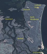
North Stradbroke Island
Encyclopedia
Australia
Australia , officially the Commonwealth of Australia, is a country in the Southern Hemisphere comprising the mainland of the Australian continent, the island of Tasmania, and numerous smaller islands in the Indian and Pacific Oceans. It is the world's sixth-largest country by total area...
n island in the state of Queensland
Queensland
Queensland is a state of Australia, occupying the north-eastern section of the mainland continent. It is bordered by the Northern Territory, South Australia and New South Wales to the west, south-west and south respectively. To the east, Queensland is bordered by the Coral Sea and Pacific Ocean...
, 30 km southeast of the capital Brisbane
Brisbane
Brisbane is the capital and most populous city in the Australian state of Queensland and the third most populous city in Australia. Brisbane's metropolitan area has a population of over 2 million, and the South East Queensland urban conurbation, centred around Brisbane, encompasses a population of...
. Before 1896 the island was part of the Stradbroke Island
Stradbroke Island
Stradbroke Island, also known as Minjerribah, was a large sand island that formed much of the eastern side of Moreton Bay near Brisbane, Queensland until the late 19th century...
. In that year a storm separated it from South Stradbroke Island
South Stradbroke Island
South Stradbroke Island is an Australian island in the state of Queensland, south of Brisbane and forms the northern end of Gold Coast. The 21 km by 2.5 km sized island is the smaller one of the two Stradbroke Islands and lies very close to the mainland. The island has hundreds of wild...
, forming the Jumpinpin Channel
Jumpinpin Channel
The Jumpinpin channel also known as The Pin lies between North Stradbroke Island and South Stradbroke Island. It has a fast moving tidal deep water Channel not appropriate for swimming but is popular with beach anglers....
. It is known colloquially as Straddie.
Geography
The island is about 38 km long and 11 km wide. North Stradbroke Island is the second largest sand island in the world. North Stradbroke, South Stradbroke and Moreton IslandMoreton Island
Moreton Island is a large sand island on the eastern side of Moreton Bay, on the coast of south-east Queensland, Australia. Moreton Island lies 58 kilometres northeast of the Queensland capital, Brisbane. The island is 95% National Park and a popular destination for four wheel driving, camping,...
act as a barrier to Moreton Bay
Moreton Bay
Moreton Bay is a bay on the eastern coast of Australia 45 km from Brisbane, Queensland. It is one of Queensland's most important coastal resources...
.
The permanent population the island is quite small, at 2000, but the number of people on the island swells significantly during the holiday season. There is no bridge to the island and the only access is by vehicular or passenger ferries
Ferry
A ferry is a form of transportation, usually a boat, but sometimes a ship, used to carry primarily passengers, and sometimes vehicles and cargo as well, across a body of water. Most ferries operate on regular, frequent, return services...
leaving from Cleveland
Cleveland, Queensland
Cleveland is a suburb located approximately east-south-east of Brisbane, the capital of the Australian state of Queensland, and is the council seat for the Redland City local government area...
.
There are three townships on the island. Dunwich
Dunwich, Queensland
Dunwich is a small town on the western side of North Stradbroke Island in the Australian state of Queensland. The town is part of the Redland City local government area, based on the mainland in the Brisbane bayside suburb of Cleveland. Dunwich is one of three towns on North Stradbroke Island -...
is the largest and has most of the island's services including a school, medical centre, local museum and university marine research station. Point Lookout
Point Lookout, Queensland
Point Lookout is a headland and small coastal village located on the eastern coast of North Stradbroke Island. To the north lies Cape Moreton and to the south the next major headland is Point Danger on the New South Wales/Queensland border. The other towns on the island are Dunwich and Amity Point....
(referred to locally as 'the point') is on the surf side of the island and is the major tourist destination in the holiday season. The third is Amity Point
Amity Point, Queensland
Amity Point is a small close knit township located on the north western point of North Stradbroke Island, Queensland, Australia in Redland City. At the 2006 census, Amity Point had a population of 408....
which is much smaller and a popular fishing spot on the island. Flinders Beach is a small settlement of mostly holiday houses located on the main beach between Amity and Point Lookout.
The remainder of the island is a locality (North Stradbroke Island) of the Redland City local government area, as are the three townships.
The two largest lakes on the island are Brown Lake
Brown Lake (Stradbroke Island)
Brown Lake is a lake on North Stradbroke Island, in Queensland, Australia.Known as a perched lake like other lakes on the sandy islands in the region of South-East Queensland it retains its water due to a layer of leaves lining the lake floor...
and Blue Lake
Blue Lake National Park
Blue Lake is a national park in Queensland , 44 km east of Brisbane on North Stradbroke Island. Access is provided by road 9 km west of Dunwich....
.
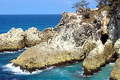
Beaches
5 main Beaches provide great fishing, surfing and water activities on North Stradbroke Island. These are Main Beach (32km long, good for surfing), Cylinder Beach (protected swimming beach with smaller swell), Home Beach (a popular swimming beach), Frenchman's Beach/Deadman's Beach (rock pools but no lifesaving service) and Flinders Beach (on the western non-surf side of the Island, offers good swimming and popular with campers).History
The native name for the island is Minjerribah but in 1827 Captain Henry John RousHenry John Rous
Admiral Henry John Rous was a Royal Navy officer and sportsman.-Career:Born the second son of John Rous, 1st Earl of Stradbroke, Rous was educated at Westminster School, and entered the Royal Navy in 1808, serving as a midshipman in the Walcheren Campaign the following year...
, who had the title of Viscount Dunwich, commander of HMS Rainbow the first British ship of war to enter Moreton Bay
Moreton Bay
Moreton Bay is a bay on the eastern coast of Australia 45 km from Brisbane, Queensland. It is one of Queensland's most important coastal resources...
, named the island after his father the Earl of Stradbroke
Earl of Stradbroke
Earl of Stradbroke, in the County of Suffolk, is a title in the Peerage of the United Kingdom. It was created in 1821 for John Rous, 1st Baron Rous, who had earlier represented Suffolk in the House of Commons...
, the town after his title, the entrance channel after himself and even gave his boat a guernsey with the naming of Rainbow Beach. However three shipwrecked sailors, Thomas Pamphlett
Thomas Pamphlett
Thomas Pamphlett , sometimes Pamphlet, also known as James Groom, was a convict in colonial Australia. He is best known for his time as a castaway in the Moreton Bay area, halfway up the eastern coast of Australia, in 1823. He was marooned with two others, Richard Parsons and John Finnegan, until...
, John Finnegan
John Finnegan
John Finnegan, a convict of the colony of New South Wales , was one of four men who set off on a timber getting mission from Sydney bound for Illawarra in 1823...
and Richard Parsons
Richard Parsons (convict)
Richard Parsons, a convict of the colony of New South Wales , was one of four men who set off on a timber getting mission from Sydney bound for Illawarra in 1823...
, spent time on Stradbroke Island after they were washed ashore in 1823. The local Aboriginal people supplied them with food and shelter and even gave them a canoe to help them on their way. Before these three, Matthew Flinders
Matthew Flinders
Captain Matthew Flinders RN was one of the most successful navigators and cartographers of his age. In a career that spanned just over twenty years, he sailed with Captain William Bligh, circumnavigated Australia and encouraged the use of that name for the continent, which had previously been...
called in at Stradbroke Island for fresh water and also mapped a large section of Moreton Bay. Flinders was impressed by the Stradbroke Aborigines' health and hospitality. Well known local historian, Thomas Welsby, records an Aboriginal oral tradition that there was an even earlier contact with European shipwreck survivors who walked into one of the Aboriginal camps after their ship was wrecked on the ocean side of Stradbroke Island. This tradition states that one of the men's name was Juan and the other's was Woonunga. In 1890 a member of the Campbell family, one of Stradbroke's oldest mixed blood families, told Welsby that the remains of the ship were still visible in the 18 Mile Swamp and that the remains were of English oak. This story gives rise to a local legend that the remains of a Spanish or Portuguese shipwreck known as the Stradbroke Island Galleon exist somewhere in the 18 Mile Swamp.
North Stradbroke Island's most famous local was Oodgeroo Noonuccal
Oodgeroo Noonuccal
Oodgeroo Noonuccal was an Australian poet, political activist, artist and educator. She was also a campaigner for Aboriginal rights...
, formerly known as Kath Walker, the Aboriginal poet and native-rights campaigner. She was one of the prime-movers of the movement that lead to the 1997 landmark agreement between the local government council
Redland Shire, Queensland
Redland City is a Local Government Area of South East Queensland, spread along the southern coast of Moreton Bay covering . Between the cities of Brisbane to the north, Logan to the west, and the Gold Coast to the south, it is part of the fastest growing area in Queensland and one of the fastest...
and the aboriginal people of the area claiming rights over the island and parts of Moreton Bay.
In 2000, Matthew Hayden
Matthew Hayden
Matthew Lawrence Hayden AM is a former Australian cricketer, and was signed to the Chennai Super Kings in the IPL until the 2010 season. Hayden is a powerful and aggressive left-handed opening batsman, known for his ability to score quickly at both Test and one day levels.Hayden holds the record...
's boat capsized whilst sailing near North Stradbroke Island. He and his two companions which included Andrew Symonds
Andrew Symonds
Andrew Symonds is a former Australian cricket team all-rounder. A two-time World Cup winner, Symonds is a right-handed middle order batsman and alternates between medium pace and off-spin bowling....
, were forced to swim a kilometre to safety. Hayden subsequently appeared in a campaign promoting marine safety.
Mining
During the 1960s sand miningSand mining
Sand mining is a practice that is becoming an environmental issue as the demand for sand increases in industry and construction. Sand is mined from beaches and inland dunes and dredged from ocean beds and river beds. It is often used in manufacturing as an abrasive, for example, and it is used to...
operations began mining the islands frontal dunes. Mining moved into the interior of the island in the late 1960s and increased in scale and size. As an alternative, development of the island for seaside residential use was mooted and in 1970 a bridge from the mainland via Russell Island
Russell Island, Queensland
Russell Island in Redland City is the biggest of the Southern Moreton Bay Islands, sandwiched between the mainland and North Stradbroke Island in the state of Queensland, Australia. The island is eight kilometres long and nearly three kilometres wide.-History:A basic survey of the island was...
was under serious consideration by the Queensland government. The Queensland government also proposed a large scale redevelopment of the island in the mid 1980's which would have seen the population of the island increase 10 fold. This proposal was never followed through when the incumbent government lost office. From the 1960s to the 1980s sand miners mined the frontal dunes of the ocean beach from Jumpinpin to Point Lookout. This mining activity destroyed numerous ancient Aboriginal middens and campsites in the sheltered areas behind the frontal dunes. Unique ecosystems which lay between the 18 Mile Swamp and the ocean were also destroyed. Generally there was little more than a token effort to re-vegetate mined areas so that 30 years after the area was mined the dunal areas are still ecologically devastated. There is also strong anecdotal evidence that in the 1960s one of the early mining companies destroyed a shipwreck located in the sand dunes near Jumpinpin which may have been the reputed Stradbroke Galleon. There are several accounts from sand mining employees of unusual artifacts being found during dredging operations.
However, the understanding of the island's environmental and native heritage value was on the rise. In 1991 the Australian Government and sand mining companies ACI and Consolidated Rutile Pty Ltd attempted to reach an agreement on surrender of some or parts of mining lease tenements to form a national park
National park
A national park is a reserve of natural, semi-natural, or developed land that a sovereign state declares or owns. Although individual nations designate their own national parks differently A national park is a reserve of natural, semi-natural, or developed land that a sovereign state declares or...
. Half of North Stradbroke Island was to become a national park in return for a guarantee that mining could continue for the life of several mines in high grade areas 1. The agreement was never signed by either of the mining companies nor the government and has not been progressed to this day. Mineral sands and silica sands at Myora Mine, near Dunwich, are currently being mined from the surface. Rutile
Rutile
Rutile is a mineral composed primarily of titanium dioxide, TiO2.Rutile is the most common natural form of TiO2. Two rarer polymorphs of TiO2 are known:...
, zircon
Zircon
Zircon is a mineral belonging to the group of nesosilicates. Its chemical name is zirconium silicate and its corresponding chemical formula is ZrSiO4. A common empirical formula showing some of the range of substitution in zircon is 1–x4x–y...
and ilmenite
Ilmenite
Ilmenite is a weakly magnetic titanium-iron oxide mineral which is iron-black or steel-gray. It is a crystalline iron titanium oxide . It crystallizes in the trigonal system, and it has the same crystal structure as corundum and hematite....
are dredged from the Yarraman Mine on the north of the island and the Enterprise Mine on the south of the island by Consolidated Rutile Limited (CRL). In 2009, 500,000 tonnes of minerals were being produced by mining about 50 million tonnes of sand. Enterprise is the largest mine on the island and accounted for 60% of the island's production in 2011.
According to the Stradbroke Island Management Organisation (an environmental watch-dog organisation) two-thirds of the island is covered by mining leases. In late 2009, CSR, which became a subsidiary of Unimin Australia
Unimin
Unimin Corporation is the American subsidiary of Sibelco and the United States' leading producer of silica sand. Unimin specializes in industrial minerals....
, itself a subsidiary of Sibelco
Sibelco
Sibelco has over 245 production units worldwide and is the disputed market leader in the extraction, production and distribution of the main industrial minerals: quartz, cristobalite, nepheline syenite, plastic clay and olivine...
, after being purchased from Iluka Resources
Iluka Resources
Iluka Resources is a mining company involved in the mining and processing of titanium based and zircon products. The company mines heavy mineral sands and separates the concentrate into its individual mineral constituents rutile, ilmenite, leucoxene and zircon...
, was charged with illegal sand mining after it sold sand extracted from the island, to the building industry for the production of glass.
In 2010, the State government announced that sand mining on the island would be phased out by 2027. According to an article published by one of the sand mining companies, the announcement caused concern amongst residents as half of the island's economy is supported by that mine operator Unimin. Plans to decommission mining were changed once again, when on 22 March 2011 the Queensland Premier Anna Bligh
Anna Bligh
Anna Maria Bligh is an Australian politician and the Premier of Queensland since 2007. The 2009 Queensland state election was the first time a female-led political party won or retained state or federal government in Australia...
announced that the Enterprise Mine will now be forced to shut in 2019, eight years earlier than previously agreed. Yarraman will close in 2015 and Vance in 2025. The decision increased concerns for the local economy.
Eventually 80% of the island will become national park. The state government is planning to develop tourism opportunities by creating new walking tracks, camping grounds and recreational facilities.
See also
- Bribie Island
- North Stradbroke Island Historical MuseumNorth Stradbroke Island Historical MuseumThe North Stradbroke Island Historical Museum is a museum founded in 1987 to present the history of North Stradbroke Island. It is found at 15-17 Welsby Street, in Dunwich on North Stradbroke Island. The museum comprises four buildings: the Dunwich Benevolent Asylum, the main building, the...
- Point Lookout Lighthouse, AustraliaPoint Lookout Lighthouse, AustraliaPoint Lookout Light is an active lighthouse on Point Lookout, a headland on North Stradbroke Island, Queensland, Australia.-History:A proposal for a lighthouse and a signal station on Point Lookout were made as early as 1825. A pilot station was built in 1825 elsewhere on the island, on Amity...
External links
- North Stradbroke Island's Official Website
- North Stradbroke Island, Moreton Bay, Australia. Shore and Beach, 2006, 74:2 38-39
- The Stradbroke Island Galleon
- Commonwealth of Australia Senate Committee Hansard Report 1998 Further statements on the environmental issues by the people of North Stradbroke