

Sherwood, Queensland
Encyclopedia
Sherwood is a suburb of Brisbane
, Australia
. It is 9 km south west of the CBD and borders the Brisbane River
. The suburb is mostly low and medium density housing with a retail strip centered along Sherwood Road.
and lake fronting the river which was planned and landscaped in the 1920s.
and a Woolworths supermarket.
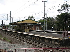 The suburb is serviced by the Sherwood Railway Station
which links Ipswich
to the Brisbane central business district
. Bus services along Oxley Road link the Centenary suburbs to Indooroopilly
and the Great Circle Line service passes through the suburb.
Sherwood State School was originally was known as West Oxley State School and opened on 25 March 1867 (other records indicate 23 March). The first head teacher (Headmaster) appointed to the school was Major William Jenyns Boyd. He was born in Paris on 1842 and migrated to Australia in 1862.
In 1868 Oliver Radcliffe was the first name on the roll as a pupil/teacher.
Other significant ‘finger prints’ in Sherwood State School’s heritage include:
1874 – School builds first Water Closet (toilet);
1878 – School changed its name to Sherwood State School.
1890 – Shingle roofing replaced with corrugated iron;
1893 – Measles and influenza out break reported;
1914 – World War 1;
1917 – Three additional classrooms added;
1925 – Students planted 100 trees in school grounds;
1926 – Limited electricity was provided;
1927 – 33 additional 3 acres (12,140.6 m²) of land purchased;
1928 – First telephone installed
1936 – Three more classrooms added; electrical gramophone and wireless (radio) provided to the school
1937 – School moved to its current location/site.
1939 – World War Two began with a first aide, ambulance post and air raid trenches placed under buildings;
1950 – Polio outbreak;
1959 – School enrolment peaked at 1034 students;
1962 – Tuck Shop opened;
1965 – Parent and Citizen’s Association was formed; tennis court resealed and fenced;
1967 – Pool opened;
1984 – School purchased first computer;
1991 – After school care services established;
2000 – School Hall opens;
2006 – Preparatory building constructed
2007 – Inaugural prep class commences;
Brisbane
Brisbane is the capital and most populous city in the Australian state of Queensland and the third most populous city in Australia. Brisbane's metropolitan area has a population of over 2 million, and the South East Queensland urban conurbation, centred around Brisbane, encompasses a population of...
, Australia
Australia
Australia , officially the Commonwealth of Australia, is a country in the Southern Hemisphere comprising the mainland of the Australian continent, the island of Tasmania, and numerous smaller islands in the Indian and Pacific Oceans. It is the world's sixth-largest country by total area...
. It is 9 km south west of the CBD and borders the Brisbane River
Brisbane River
The Brisbane River is the longest river in south east Queensland, Australia, and flows through the city of Brisbane, before emptying into Moreton Bay. John Oxley was the first European to explore the river who named it after the Governor of New South Wales, Thomas Brisbane in 1823...
. The suburb is mostly low and medium density housing with a retail strip centered along Sherwood Road.
Open Space
The suburb is home to the Sherwood Arboretum, a large botanical gardenBotanical garden
A botanical garden The terms botanic and botanical, and garden or gardens are used more-or-less interchangeably, although the word botanic is generally reserved for the earlier, more traditional gardens. is a well-tended area displaying a wide range of plants labelled with their botanical names...
and lake fronting the river which was planned and landscaped in the 1920s.
Commercial area
There are a number of cafes, including the Coffee ClubCoffee Club
Uniting for Consensus is a movement, nicknamed the Coffee Club, that developed in the 1990s in opposition to the possible expansion of the United Nations Security Council...
and a Woolworths supermarket.
Transport
Sherwood railway station, Brisbane
Sherwood Station is a railway station located in the Brisbane suburb of Sherwood, Queensland, Australia, on the Ipswich and Rosewood and Springfield lines. Trains to the City arrive on platform 2 while trains outbound arrive on platform 1.-History:...
which links Ipswich
Ipswich, Queensland
Ipswich is a city in South-East Queensland, Australia. Situated along the Bremer River Valley approximately 40 kilometres away from the state's capital Brisbane. The suburb by the same name forms the city's Central Business District and administrative centre...
to the Brisbane central business district
Brisbane central business district
The Brisbane central business district , sometimes referred to as the city, is a suburb of Brisbane, Queensland, Australia and is located on a point on the northern bank of the Brisbane River. The triangular shaped area is bounded by the Brisbane River to the east, south and west...
. Bus services along Oxley Road link the Centenary suburbs to Indooroopilly
Indooroopilly, Queensland
Indooroopilly is a suburb of Brisbane, Australia which is located 7 km west of the Brisbane central business district.- Name derivation and history :...
and the Great Circle Line service passes through the suburb.
Education
Sherwood State School, established in 1867 is one of the oldest schools in the state and still has preserved many of its original timber buildings.Sherwood State School was originally was known as West Oxley State School and opened on 25 March 1867 (other records indicate 23 March). The first head teacher (Headmaster) appointed to the school was Major William Jenyns Boyd. He was born in Paris on 1842 and migrated to Australia in 1862.
In 1868 Oliver Radcliffe was the first name on the roll as a pupil/teacher.
Other significant ‘finger prints’ in Sherwood State School’s heritage include:
1874 – School builds first Water Closet (toilet);
1878 – School changed its name to Sherwood State School.
1890 – Shingle roofing replaced with corrugated iron;
1893 – Measles and influenza out break reported;
1914 – World War 1;
1917 – Three additional classrooms added;
1925 – Students planted 100 trees in school grounds;
1926 – Limited electricity was provided;
1927 – 33 additional 3 acres (12,140.6 m²) of land purchased;
1928 – First telephone installed
1936 – Three more classrooms added; electrical gramophone and wireless (radio) provided to the school
1937 – School moved to its current location/site.
1939 – World War Two began with a first aide, ambulance post and air raid trenches placed under buildings;
1950 – Polio outbreak;
1959 – School enrolment peaked at 1034 students;
1962 – Tuck Shop opened;
1965 – Parent and Citizen’s Association was formed; tennis court resealed and fenced;
1967 – Pool opened;
1984 – School purchased first computer;
1991 – After school care services established;
2000 – School Hall opens;
2006 – Preparatory building constructed
2007 – Inaugural prep class commences;