
Strathpine, Queensland
Encyclopedia
Strathpine is a suburb north of Brisbane
, Queensland
, Australia
. Its Local Government Area is the Moreton Bay Region. It is home to the Pine Rivers District offices of the Moreton Bay Region as well as many businesses. The area contains a medium-sized Westfield
shopping centre. Strathpine is a Scottish place name, it means a large valley with a river and pine trees.
gold rush. In the late 19th century, the area was known for sugar and rum production, with several sugar mills and distilleries in the area. The area was first named Strathpine by the Queensland Government Railways
in the 1880s. The first school opened in Strathpine in the 1910s.
The population of the area boomed in the 1940s after the opening of a large army camp and airfield which helped both Australian and American forces during World War II
. Development slowly increased until the 1960s when Brisbane’s rapidly growing population expanded into the area. Most of the farms were sold off and the area quickly grew into a residential and commercial hub.
Growth continued into the 1980s and Westfield Strathpine
opened on 22 August 1983. In recent years, the main road which passes through Strathpine (Gympie Road) has undergone gentrification or urban renewal. Gympie Road is tree-lined with trees of Pine
species.
on QR
Citytrain
's Caboolture railway line
has frequent services to Brisbane and Caboolture
.
Strathpine Bus Station
at Westfield Strathpine has many services frequently departing to other areas of the Pine Rivers Shire, Redcliffe, Chermside
and Toombul. Buses to Brisbane only operate at peak times.
There is also an extensive footpath network, provided by Pine Rivers Shire Council (now Moreton Bay Region), around Strathpine.
Brisbane
Brisbane is the capital and most populous city in the Australian state of Queensland and the third most populous city in Australia. Brisbane's metropolitan area has a population of over 2 million, and the South East Queensland urban conurbation, centred around Brisbane, encompasses a population of...
, Queensland
Queensland
Queensland is a state of Australia, occupying the north-eastern section of the mainland continent. It is bordered by the Northern Territory, South Australia and New South Wales to the west, south-west and south respectively. To the east, Queensland is bordered by the Coral Sea and Pacific Ocean...
, Australia
Australia
Australia , officially the Commonwealth of Australia, is a country in the Southern Hemisphere comprising the mainland of the Australian continent, the island of Tasmania, and numerous smaller islands in the Indian and Pacific Oceans. It is the world's sixth-largest country by total area...
. Its Local Government Area is the Moreton Bay Region. It is home to the Pine Rivers District offices of the Moreton Bay Region as well as many businesses. The area contains a medium-sized Westfield
Westfield Strathpine
Westfield Strathpine is a regional shopping centre located in Strathpine, a suburb in Moreton Bay, north of Brisbane.The centre was built and opened in 1983 by The Westfield Group. It is anchored by Big W and Target discount department stores, Woolworths supermarket, Coles supermarket and ALDI Food...
shopping centre. Strathpine is a Scottish place name, it means a large valley with a river and pine trees.
History
The area now known as Strathpine was originally developed in the 1860s as an addition to the North Pine settlement during the GympieGympie
Gympie may refer to:* Gympie, a city in Queensland, Australia** Gympie Airport** Electoral district of Gympie** Gympie Region, its local government authority* Gympie Gympie , a stinging plant...
gold rush. In the late 19th century, the area was known for sugar and rum production, with several sugar mills and distilleries in the area. The area was first named Strathpine by the Queensland Government Railways
Queensland Rail
Queensland Rail, also known as QR, is a government-owned railway operator in the state of Queensland. Under the control of the Queensland Government, Queensland Rail operates the inner-city and long-distance passenger services, as well as some freight operations and gives railway access to other...
in the 1880s. The first school opened in Strathpine in the 1910s.
The population of the area boomed in the 1940s after the opening of a large army camp and airfield which helped both Australian and American forces during World War II
World War II
World War II, or the Second World War , was a global conflict lasting from 1939 to 1945, involving most of the world's nations—including all of the great powers—eventually forming two opposing military alliances: the Allies and the Axis...
. Development slowly increased until the 1960s when Brisbane’s rapidly growing population expanded into the area. Most of the farms were sold off and the area quickly grew into a residential and commercial hub.
Growth continued into the 1980s and Westfield Strathpine
Westfield Strathpine
Westfield Strathpine is a regional shopping centre located in Strathpine, a suburb in Moreton Bay, north of Brisbane.The centre was built and opened in 1983 by The Westfield Group. It is anchored by Big W and Target discount department stores, Woolworths supermarket, Coles supermarket and ALDI Food...
opened on 22 August 1983. In recent years, the main road which passes through Strathpine (Gympie Road) has undergone gentrification or urban renewal. Gympie Road is tree-lined with trees of Pine
Pine
Pines are trees in the genus Pinus ,in the family Pinaceae. They make up the monotypic subfamily Pinoideae. There are about 115 species of pine, although different authorities accept between 105 and 125 species.-Etymology:...
species.
Education
The Strathpine area is home to several schools including:- Strathpine State School
- Strathpine West State School
- Pine Rivers State High SchoolPine Rivers State High SchoolPine Rivers State High School is an Australian Queensland state secondary school situated north of Brisbane in the suburb of Strathpine.-Sporting Houses:...
Public transport
Strathpine railway stationStrathpine railway station, Brisbane
Strathpine Station is a railway station on the Caboolture Line of Brisbane, Australia. It is part of the QR Citytrain network.The station is in Zone 5 of the TransLink integrated public transport system.-Services by platform:...
on QR
Queensland Rail
Queensland Rail, also known as QR, is a government-owned railway operator in the state of Queensland. Under the control of the Queensland Government, Queensland Rail operates the inner-city and long-distance passenger services, as well as some freight operations and gives railway access to other...
Citytrain
CityTrain
Citytrain is the brand name of urban, suburban and inter-urban electric passenger railway services in South East Queensland, Australia. Its network, centering in Brisbane, the state capital of Queensland, is approximately in route length...
's Caboolture railway line
Caboolture railway line, Brisbane
The Caboolture railway line is a suburban railway line in Brisbane, the state capital of Queensland, Australia. It branches from the Ferny Grove line at Bowen Hills. It runs through Brisbane's northern suburbs to Caboolture, and connects to the Sunshine Coast via the North Coast line, and connects...
has frequent services to Brisbane and Caboolture
Caboolture, Queensland
Caboolture is an urban centre approximately north of Brisbane, the state capital of Queensland, Australia. Caboolture is considered to be the northernmost urban area of the greater Brisbane metropolitan region within South East Queensland, and it marks the end of the Brisbane suburban commuter...
.
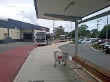
Strathpine Bus Station
Strathpine Bus Station, Brisbane
The Strathpine Bus Station, at Westfield Strathpine, is serviced by TransLink bus routes. It is a major interchange for TransLink's Northern Region. It is in Zone 5 of the TransLink integrated public transport system.- TransLink bus navigation :...
at Westfield Strathpine has many services frequently departing to other areas of the Pine Rivers Shire, Redcliffe, Chermside
Chermside, Queensland
Chermside is a suburb on the north side of Brisbane, Queensland, Australia.Chermside is a key destination along Queensland Transport's future Northern Busway...
and Toombul. Buses to Brisbane only operate at peak times.
Road transport
Strathpine CBD is centered around Gympie Road, which is a major road towards Brisbane. Other major roads include:- Samsonvale Road – to WarnerWarner, QueenslandWarner is a suburb north of Brisbane, Queensland, Australia. Its Local Government Area is the Moreton Bay Region located 22 kilometres north of the Brisbane central business district. Warner is situated east of Lake Samsonvale and west of the urban localities of Strathpine, Brendale, Bray Park and...
- South Pine Road – to Brendale, Albany CreekAlbany Creek, QueenslandAlbany Creek is a suburb located approximately 17 kilometres north-west of Brisbane, Australia; about a half hour drive to the central business district.- History :...
- Strathpine Road – a replacement to Gympie Road between Bald HillsBald Hills, QueenslandBald Hills is the northernmost suburb of the Brisbane City Council in Queensland, Australia.Bald Hills is a largely residential suburb. It is mostly surrounded by bushland, but in the last few years some of the bush areas have been cleared to make way for new residential areas...
and Hoyland Street to Bracken RidgeBracken Ridge, QueenslandBracken Ridge is a northern suburb of Brisbane, the capital city of Queensland, Australia. Its local government area is the City of Brisbane, in which it has its own ward.-Location:...
.
There is also an extensive footpath network, provided by Pine Rivers Shire Council (now Moreton Bay Region), around Strathpine.