
Tarragindi, Queensland
Encyclopedia
Tarragindi is a suburb on the southern side of Brisbane
, Queensland
, Australia
. It is represented through the Holland Park and Moorooka Ward councillors on the Brisbane City Council.
(near modern-day New Caledonia) who was transported in the late nineteenth century to Queensland. Such people, called Kanakas
, were a cheap source of labour for sugarcane production. Apparently he escaped and was subsequently employed by Alfred Foote of Ipswich
. Later, he cleared land for William Grimes (related to Alfred Foote) on a hill near Sandy Creek and the property was named after him. Tarragindi remained with the Foote family in Ipswich until just before he died, aged 63. The grave of Tarra Gindi Tasserone is located in the Ipswich Cemetery.
 Prior to European occupation beginning in the early 19th century the area covered by the suburb was inhabited by Aboriginal people. According to Kidd (2000) the Coorparoo sub-group of the wider Jagera
group occupied land south of the Brisbane River clustered around Oxley, Norman and Bulimba creeks. It is also possible that the Yerongpan sub-group lived in the area (BRISbites, n.d.). The Coorparoo group had cultural links to other neighboring communities including territorially-neutral pathways, river crossings and ceremonies. A bora ring was known to have been maintained in Tarragindi, possibly between present-day Barnehurst and Isabella Streets (BRISBites, n.d.). One trace of this early occupation persists in the locality and creek name, "Ekibin". According to Queensland Department of Natural Resources and Mines (2003) the modern name is derived from the aboriginal "Yekkabin" which referred to aquatic plants (possibly Typha angustifolia
or Blechnum indicum) with edible roots which grew in the creek. According to Potter (n.d.) the edible roots were common in the diet of Aboriginals of the Moreton Bay area. A sharp stick was used to dig out the stem, which was then dried, roasted, and pounded with a stone.
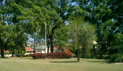 During the Second World War, Tarragindi was the site of a field hospital administered first by the American Army (for soldiers treated for shell shock) and later by the British and Australian forces. According to Dunn (2001) the Ekibin Hospital was bounded by Sexton Street and Toohey Road and encompassed parts of Cracknell, Effingham, Fingal and Lutzow streets. After the war, the site was used by the Housing Commission to accommodate displaced persons. Today, little remains of the establishment except for possible foundations of a gun emplacement in the mid-section of Fingal Street. The Ekibin Memorial Park on Cracknell Road commemorates the establishment of the hospital.
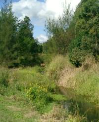
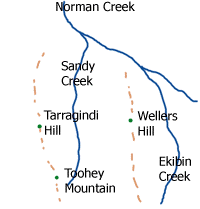 The main part of the suburb lies in a valley running north-south, surrounded by ridges marked by Wellers Hill to the east and Tarragindi Hill to the west. Sandy Creek has it source in Toohey Forest to the south and flows through the major part of the suburb. The eastern flank of the Wellers Hill ridge drains into Ekibin Creek.
 Tarragindi hosts two primary schools. The Wellers Hill Primary School is located on the junction of Weller and Toohey Roads. The school has a very active music program. In December 2006 the school lost some buildings due to an arson attack. St. Elizabeth's Catholic Primary School is located nearby on Cracknell Road.
Brisbane
Brisbane is the capital and most populous city in the Australian state of Queensland and the third most populous city in Australia. Brisbane's metropolitan area has a population of over 2 million, and the South East Queensland urban conurbation, centred around Brisbane, encompasses a population of...
, Queensland
Queensland
Queensland is a state of Australia, occupying the north-eastern section of the mainland continent. It is bordered by the Northern Territory, South Australia and New South Wales to the west, south-west and south respectively. To the east, Queensland is bordered by the Coral Sea and Pacific Ocean...
, Australia
Australia
Australia , officially the Commonwealth of Australia, is a country in the Southern Hemisphere comprising the mainland of the Australian continent, the island of Tasmania, and numerous smaller islands in the Indian and Pacific Oceans. It is the world's sixth-largest country by total area...
. It is represented through the Holland Park and Moorooka Ward councillors on the Brisbane City Council.
Origin of the name
The suburb appears to have been named after a native from the Loyalty IslandsLoyalty Islands
The Loyalty Islands are an archipelago in the Pacific. They are part of the French territory of New Caledonia, whose mainland is away. They form the Loyalty Islands Province , one of the three provinces of New Caledonia...
(near modern-day New Caledonia) who was transported in the late nineteenth century to Queensland. Such people, called Kanakas
Kanakas
Kanaka was the term for a worker from various Pacific Islands employed in British colonies, such as British Columbia , Fiji and Queensland in the 19th and early 20th centuries...
, were a cheap source of labour for sugarcane production. Apparently he escaped and was subsequently employed by Alfred Foote of Ipswich
Ipswich, Queensland
Ipswich is a city in South-East Queensland, Australia. Situated along the Bremer River Valley approximately 40 kilometres away from the state's capital Brisbane. The suburb by the same name forms the city's Central Business District and administrative centre...
. Later, he cleared land for William Grimes (related to Alfred Foote) on a hill near Sandy Creek and the property was named after him. Tarragindi remained with the Foote family in Ipswich until just before he died, aged 63. The grave of Tarra Gindi Tasserone is located in the Ipswich Cemetery.
History
Jagera
Jagera is a genus of 4 species of small tree in the soapberry family Sapindaceae. Three are found in the rainforests of eastern Australia, the other is found in the Moluccas and New Guinea....
group occupied land south of the Brisbane River clustered around Oxley, Norman and Bulimba creeks. It is also possible that the Yerongpan sub-group lived in the area (BRISbites, n.d.). The Coorparoo group had cultural links to other neighboring communities including territorially-neutral pathways, river crossings and ceremonies. A bora ring was known to have been maintained in Tarragindi, possibly between present-day Barnehurst and Isabella Streets (BRISBites, n.d.). One trace of this early occupation persists in the locality and creek name, "Ekibin". According to Queensland Department of Natural Resources and Mines (2003) the modern name is derived from the aboriginal "Yekkabin" which referred to aquatic plants (possibly Typha angustifolia
Typha
Typha is a genus of about eleven species of monocotyledonous flowering plants in the family Typhaceae. The genus has a largely Northern Hemisphere distribution, but is essentially cosmopolitan, being found in a variety of wetland habitats...
or Blechnum indicum) with edible roots which grew in the creek. According to Potter (n.d.) the edible roots were common in the diet of Aboriginals of the Moreton Bay area. A sharp stick was used to dig out the stem, which was then dried, roasted, and pounded with a stone.
European settlement
European settlement began 1857 with a survey of land by George Pratten. An early land-owner (and later Mayor of Brisbane and member of parliament), Thomas Stevens, established a woolscour and later a fellmongery in the northern part of the suburb near Essie Avenue. Another land-holder was James Toohey who leased properties for cattle runs.
Geography
Schools