
Coorparoo, Queensland
Encyclopedia
Coorparoo is a southern suburb
of Brisbane
, Queensland
, Australia
, located approximately four kilometres from the city. Surrounding suburbs include Camp Hill
, Holland Park
, Greenslopes
, East Brisbane
, Norman Park
and Seven Hills
.
and generally camped along creeks. Their name comes from Kulpurum, which was the word for Norman Creek
or a tributary of it. They continued to occupy watercourse campsites after white settlement, but other clans from the region began to move into South Brisbane.
In 1846 there were reports of Aborigines raiding produce along Norman Creek. In 1853, there was a fight between Ningy Ningy, Bribie Island, Amity Point, and Logan peoples at Norman Creek. A visitor in 1855 reported many camps and fishing spots between Stones Corner and the mouth of Norman Creek. In 1959 an eighty-year-old woman told of frequent corroboree
s on the banks of the creek in Norman Park. Corroborees were also held at a little creek that crossed Norfolk Street.
On 17 June 1856, ten farms were sold from the Parish
of Bulimba near Stones Corner. Investors bought all but two of them. The next year James Warner surveyed land on the other side of the road for a second land auction.
Samuel Stevens donated two acres of his property near the junction of Cavendish and Old Cleveland Roads for use of a school. He declined the offer of naming the area "Steven's Town" and on 22 March 1875, a meeting of local residents at the Wecker's house resolved that the 'name of the locality, together with the proposed primary school, should be Coorparoo'.
In 1876, the Coorparoo State School was opened and Frederick Robinson began offering public transport in a wagonette
from Coorparoo Junction to Victoria Bridge. The 1880s land boom was a spur to profit from land. John Black was the first to subdivide land in the area in 1882 and later a variety of subdivisions were offered to the public. The construction of the bridge at Stanley Street (1886) and the development of the Stanley Bridge Estate made the area more attractive to purchasers. In 1887 the tramway was extended to Buranda
, putting the western end of Coorparoo close to tram travel.
Coorparoo had been part of the Bulimba Divisional Boards since 1879. However, in 1888, as a result of dissatisfaction with this situation, a petition
was taken and Coorparoo Shire was created. A bridge was built at Burnetts Swamp (Stones Corner) and important road improvements took place. Development was taking off. In 1889 there were 2,500 people in the shire.
The floods of 1889 and 1893
hit the low-lying areas of Coorparoo. The flooding combined with the 1890s depression slowed development in the area. In 1900 there were actually fewer houses than there had been ten years earlier. The settlement was dense from Stones Corner to Kirkland Avenue (originally named Wecker Street but it was changed in 1914 in the wake of anti-German sentiment
), but further out it was mainly bush with a few isolated farms and houses. The only major industry was the brickworks
of Abraham James at St Leonards Street, which employed eighty men in the 1880s.
After World War I
, land prices increased as property sales boomed. Coorparoo did not really begin to expand again until the tram
service was extended to Stones Corner in 1902 and Coorparoo Junction in 1915. The number of houses increased from 613 in 1911 to 1,467 ten years later. Development in Coorparoo had taken off.
who play their home games at Langlands Park
. Langlands Park regularly hosts training sessions for the Queensland
and Australian Rugby League teams when they are playing in Brisbane.
The Brisbane Lions
train during the week at Giffin Park, also in Coorparoo.
Suburb
The word suburb mostly refers to a residential area, either existing as part of a city or as a separate residential community within commuting distance of a city . Some suburbs have a degree of administrative autonomy, and most have lower population density than inner city neighborhoods...
of Brisbane
Brisbane
Brisbane is the capital and most populous city in the Australian state of Queensland and the third most populous city in Australia. Brisbane's metropolitan area has a population of over 2 million, and the South East Queensland urban conurbation, centred around Brisbane, encompasses a population of...
, Queensland
Queensland
Queensland is a state of Australia, occupying the north-eastern section of the mainland continent. It is bordered by the Northern Territory, South Australia and New South Wales to the west, south-west and south respectively. To the east, Queensland is bordered by the Coral Sea and Pacific Ocean...
, Australia
Australia
Australia , officially the Commonwealth of Australia, is a country in the Southern Hemisphere comprising the mainland of the Australian continent, the island of Tasmania, and numerous smaller islands in the Indian and Pacific Oceans. It is the world's sixth-largest country by total area...
, located approximately four kilometres from the city. Surrounding suburbs include Camp Hill
Camp Hill, Queensland
Camp Hill is a largely residential suburb in the south-east of Brisbane, Queensland, Australia. It is located approximately 4 km from the Brisbane central business district and, as its name suggests, is elevated and commands fine views of the CBD. It has an area of 4.6 square...
, Holland Park
Holland Park, Queensland
Holland Park is a suburb of Brisbane, the capital city of Queensland, Australia, that is situated approximately 8 km south of the Brisbane central business district. Holland Park is an older suburb made of largely post-World War II wooden homes. In fact over 89% of dwellings are houses.Logan...
, Greenslopes
Greenslopes, Queensland
Greenslopes is a moderately sized suburb of the city of Brisbane, state capital of Queensland, Australia."Greenslopes" is also the name of a Queensland state electorate. The electorate contains only a small fraction of the suburb of the same name...
, East Brisbane
East Brisbane, Queensland
East Brisbane is an inner suburb of Brisbane, Australia located 3 km east of the Brisbane CBD. It is predominantly residential, with some original "Queenslander" style homes, but with an increasing number of apartment blocks. Major roads include Lytton Road, Wellington Road and Latrobe...
, Norman Park
Norman Park, Queensland
Norman Park is a suburb in Brisbane, Australia. It is located 4 km east of the Brisbane central business district.Norman Park has numerous parks and recreational areas for residents in the area...
and Seven Hills
Seven Hills, Queensland
Seven Hills is a suburb located on the inner eastern side of Brisbane, surrounded by the suburbs of Norman Park, Morningside and Carina.Between 1912 and 1926 the southern edge of the suburb was serviced by a steam tram which connected with the Queensland Government Railway at Norman Park. ...
.
Aboriginal history
The Coorparoo Clan lived south of the Brisbane RiverBrisbane River
The Brisbane River is the longest river in south east Queensland, Australia, and flows through the city of Brisbane, before emptying into Moreton Bay. John Oxley was the first European to explore the river who named it after the Governor of New South Wales, Thomas Brisbane in 1823...
and generally camped along creeks. Their name comes from Kulpurum, which was the word for Norman Creek
Norman Creek
Norman Creek is a small tributary of the Brisbane River. The headwaters of the creek are located on the northern slopes of Toohey Mountain and Mount Gravatt in southern Brisbane.Edmund Lockyer named the waterway Norman Creek in 1825....
or a tributary of it. They continued to occupy watercourse campsites after white settlement, but other clans from the region began to move into South Brisbane.
In 1846 there were reports of Aborigines raiding produce along Norman Creek. In 1853, there was a fight between Ningy Ningy, Bribie Island, Amity Point, and Logan peoples at Norman Creek. A visitor in 1855 reported many camps and fishing spots between Stones Corner and the mouth of Norman Creek. In 1959 an eighty-year-old woman told of frequent corroboree
Corroboree
A corroboree is a ceremonial meeting of Australian Aborigines. The word was coined by the European settlers of Australia in imitation of the Aboriginal word caribberie. At a corroboree Aborigines interact with the Dreamtime through dance, music and costume. Many ceremonies act out events from the...
s on the banks of the creek in Norman Park. Corroborees were also held at a little creek that crossed Norfolk Street.
Urban development
Coorparoo was named by the residents at a public meeting on 22 March 1875. The name Coorparoo comes from the Aboriginal name for Norman Creek. This had been translated as both place of the mosquito and peaceful dove. The Shire of Coorparoo was formally proclaimed in 1888.On 17 June 1856, ten farms were sold from the Parish
Parish
A parish is a territorial unit historically under the pastoral care and clerical jurisdiction of one parish priest, who might be assisted in his pastoral duties by a curate or curates - also priests but not the parish priest - from a more or less central parish church with its associated organization...
of Bulimba near Stones Corner. Investors bought all but two of them. The next year James Warner surveyed land on the other side of the road for a second land auction.
Samuel Stevens donated two acres of his property near the junction of Cavendish and Old Cleveland Roads for use of a school. He declined the offer of naming the area "Steven's Town" and on 22 March 1875, a meeting of local residents at the Wecker's house resolved that the 'name of the locality, together with the proposed primary school, should be Coorparoo'.
In 1876, the Coorparoo State School was opened and Frederick Robinson began offering public transport in a wagonette
Wagonette
A wagonette or an omnibus is a horse-drawn wagon for passenger transport. Two wooden benches along the right and left side of the wagon platform can hold several sitting people facing each other. The driver sits on a separate, front-facing bench.The term carried over to motorized vehicles...
from Coorparoo Junction to Victoria Bridge. The 1880s land boom was a spur to profit from land. John Black was the first to subdivide land in the area in 1882 and later a variety of subdivisions were offered to the public. The construction of the bridge at Stanley Street (1886) and the development of the Stanley Bridge Estate made the area more attractive to purchasers. In 1887 the tramway was extended to Buranda
Buranda, Queensland
Buranda is a locality in the southern Brisbane suburbs of Greenslopes and Annerley, in Brisbane, Australia.The location is an important transport hub for southern Brisbane. Logan Road and Ipswich Road pass through the area as does the South East Busway with a station called Buranda busway station. ...
, putting the western end of Coorparoo close to tram travel.
Coorparoo had been part of the Bulimba Divisional Boards since 1879. However, in 1888, as a result of dissatisfaction with this situation, a petition
Petition
A petition is a request to do something, most commonly addressed to a government official or public entity. Petitions to a deity are a form of prayer....
was taken and Coorparoo Shire was created. A bridge was built at Burnetts Swamp (Stones Corner) and important road improvements took place. Development was taking off. In 1889 there were 2,500 people in the shire.
The floods of 1889 and 1893
1893 Brisbane flood
The 1893 Brisbane flood, occasionally referred to as the Great Flood of 1893 or the Black February flood, occurred when the Brisbane River burst its banks on three occasions in February 1893. It is the occurrence of three major floods in the same month that saw the period named "Black February"....
hit the low-lying areas of Coorparoo. The flooding combined with the 1890s depression slowed development in the area. In 1900 there were actually fewer houses than there had been ten years earlier. The settlement was dense from Stones Corner to Kirkland Avenue (originally named Wecker Street but it was changed in 1914 in the wake of anti-German sentiment
Australian place names changed from German names
During World War I, many German-sounding place names in Australia were changed because of Anti-German sentiment. The new names were often Anglicized , given Aboriginal names , names of famous people , or battlefields . This was done through an Act of Parliament, as well as by petition...
), but further out it was mainly bush with a few isolated farms and houses. The only major industry was the brickworks
Brickworks
A brickworks also known as a brick factory, is a factory for the manufacturing of bricks, from clay or shale. Usually a brickworks is located on a clay bedrock often with a quarry for clay on site....
of Abraham James at St Leonards Street, which employed eighty men in the 1880s.
After World War I
World War I
World War I , which was predominantly called the World War or the Great War from its occurrence until 1939, and the First World War or World War I thereafter, was a major war centred in Europe that began on 28 July 1914 and lasted until 11 November 1918...
, land prices increased as property sales boomed. Coorparoo did not really begin to expand again until the tram
Tram
A tram is a passenger rail vehicle which runs on tracks along public urban streets and also sometimes on separate rights of way. It may also run between cities and/or towns , and/or partially grade separated even in the cities...
service was extended to Stones Corner in 1902 and Coorparoo Junction in 1915. The number of houses increased from 613 in 1911 to 1,467 ten years later. Development in Coorparoo had taken off.
Sports
Coorparoo is home of the Eastern Suburbs District Rugby League Football ClubEasts Tigers
The Eastern Suburbs Tigers are a rugby league club based at Langlands Park, which is in the suburb of Coorparoo in Brisbane, Australia. They competed in the Brisbane Rugby League from 1934 to 1996. From 1996 they have competed in the Queensland Cup. Their jersey is traditionally an all gold jersey...
who play their home games at Langlands Park
Langlands Park
Langlands Park is a sporting venue in the Brisbane suburb of Coorparoo, close to Stones Corner. It is the home ground of the Easts Tigers, a rugby league team that competes in the Queensland Cup.-History:...
. Langlands Park regularly hosts training sessions for the Queensland
Queensland rugby league team
The Queensland rugby league team have represented the Australian state of Queensland in rugby league football since the sport's beginnings there in 1908...
and Australian Rugby League teams when they are playing in Brisbane.
The Brisbane Lions
Brisbane Lions
The Brisbane Lions is an Australian rules football club which plays in the Australian Football League . The club is based in Brisbane, Queensland. The club was formed from the merger of the Brisbane Bears and the Fitzroy Lions in 1996...
train during the week at Giffin Park, also in Coorparoo.
Landmarks
Coorparoo has a range of distinctive homes, buildings and sites of interest, including:- Spanish Mission RevivalMission Revival Style architectureThe Mission Revival Style was an architectural movement that began in the late 19th century for a colonial style's revivalism and reinterpretation, which drew inspiration from the late 18th and early 19th century Spanish missions in California....
homes along Cavendish Road. This was a popular inter-war house style introduced from CaliforniaCaliforniaCalifornia is a state located on the West Coast of the United States. It is by far the most populous U.S. state, and the third-largest by land area...
. - Ridgelands (1880s), built for the Blundell family
- Cardington (1880s) located at the corner of Norfolk Street and Cavendish Road. This residence was built by Thomas Howling who had purchased the allotments from early settler George Harden.
- Barston Place (1880) on Norfolk Street, built for Scottish born James Burstall and named after his birthplace.
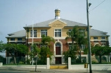
- Coorparoo Shire Hall (1892) located at the corner of Cavendish Road and Halstead Street. The building is now owned by the Coorparoo RSLReturned and Services League of AustraliaThe Returned and Services League of Australia is a support organisation for men and women who have served or are serving in the Australian Defence Force ....
Club and is now known as the Coorparoo School of Arts. - Restored Tram Post located at the corner of Old Cleveland and Cavendish Roads.
- Hatherton (1886). This elite residence was built for Reubin Nicklin who previously residence was called Langlands. Reubin and his wife Jane were drowned in the RMS QuettaRMS QuettaThe RMS Quetta was a merchant ship that wrecked on the Far North Queensland coast on 28 February 1890. Of the 292 people aboard, 134 perished.-Background:...
disaster in 1890. The house has subsequently been extensively renovated and changed and is known as the “Queen Alexandra Home” having been used as a Methodist Home for children, teaching classrooms for the local TAFE College and more recently as a community centre. - Chatsworth (1888), built for William Evans who worked at Stewarts of Stones Corner. Chatsworth Road is named after this residence.
- Langlands (1883), built for Reubin Nicklin. This building is located in the grounds of the present Villanova CollegeVillanova CollegeVillanova College is a private and catholic school for boys located in Coorparoo, a southern suburb of Brisbane, Queensland, Australia. The school has a non-selective enrolment policy for all years and caters for approximately 1,150 boys in three schools, Junior, Middle and Senior from year five to...
and is the oldest surviving masonry residence in Coorparoo. - Cavendish Road
- Kirkland House Grand Colonial Queenslander (1883), built in circa 1880, this grand colonial Queenslander located on Kirkland Avenune is one of the oldest restorated houses that wrotes a history in Coorparoo.
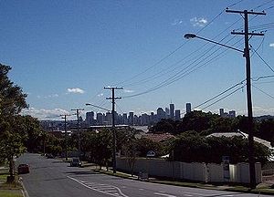
- Kirkland Avenue. An affluent tree lined street offering sweeping panoramic views of the Brisbane CBD.