
Moreton Island
Encyclopedia
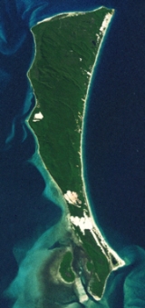
Moreton Island is a large sand island
on the eastern side of Moreton Bay
, on the coast of south-east Queensland
, Australia
. Moreton Island lies 58 kilometres northeast of the Queensland capital, Brisbane
. The island is 95% National Park and a popular destination for four wheel driving, camping, recreational angling and whale watching. Together with Fraser Island, Moreton Island forms the largest sand structure in the world.
The island was named by Matthew Flinders. At least five lighthouses have been built on the island. A small number of residents live in four small settlements. Tangalooma was the site of a whaling station. Access to the island is by vehicular barge or passenger ferry services. Moreton Island is a popular destination for camping and fishing.
It is one of the wettest parts of the City of Brisbane
with precipitation spread evenly throughout the year compared to other parts of South East Queensland
. Cape Moreton receives an annual average rainfall of 1,567 mm.
, at the north eastern tip of the island, is the only rock outcrop on the island. It was named Cape Morton by Captain James Cook
in May 1770, and was at that time assumed to be part of the mainland. The current spelling came about because of a clerical error later.
The highest point on the island is named Mount Tempest, which, at 280 m, is reputedly the highest, stablised, coastal sandhill
in the world. Close to Mount Tempest is another large sandhill—Storm Mountain at 264 m. Only in Iran are there sandhills of comparable size, measuring up to 210 m from bases to crest.
Four small settlements exist on the western side of the island. The northern most of these is Bulwer
near the north western corner of the island, whilst Cowan Cowan is approximately 4.5 kilometres further south. Approximately 6 kilometres further south lies Tangalooma Wild Dolphin Resort
. This former whaling station features a Marine Education and Conservation Centre and is known for its dolphin feeding and wreck diving
. Tangalooma is the main access point to the island with regular passenger ferry and vehicular barge services. The island's main airstrip is 1000 m long and lies between Cowan Cowan and Tangalooma. The other settlement is Kooringal which is located near the southern tip of the island. This township has its own 500 m airstrip and was serviced by a vehicular barge that ran to Amity Point
on North Stradbroke Island
until April 2009 when the barge was sold off due to limited business and high operation costs. A new vehicular barge called the Amity Trader now services the same route. The bar between the two islands is known as South Passage
and is dangerous to cross in high seas.
who, on 31 July 1799, named the island. Castaways Thomas Pamphlett
, John Finnegan
and Richard Parsons
traversed the island in March and April 1823 before heading to the mainland via Stradbroke Island. European residents settled on the island in 1848, after the Sovereign shipwrecked on the island and a pilot station was established at Bulwer. This pilot station was operated until 1909.
At Cape Moreton is Queensland's oldest lighthouse, Cape Moreton Light
, which was first lit in 1857. The lighthouse was followed by at least four other lighthouse
erected since the 1860s, at Comboyuro Point, North Point, Cowan Cowan Point and Yellow Patch. During World War II
, a number of defence installations were installed on the island by the Royal Australian Navy
and Australian Army
. These sites included anti aircraft guns and mine control buildings. Their purpose was to protect the approaches to the port of Brisbane and at its peak 900 troops were stationed on the island.
Between 1952 and 1962, Tangalooma
, on the western side of the island, was the site of Queensland's only whaling station, with humpback whale
s being harvested on their annual migration north. Each season up to 600 whales were processed with a maximum of 11 whales per day. The site of the whaling station is now the Tangalooma Wild Dolphin Resort. The flensing
plan of the station still exists as part of the resort.
Moreton Island was included in the Greater Brisbane area in 1974. The council initially permitted 60% of the island to potentially be sandmined, however a public outcry lead to the council changing the zoning to open space. The sands on the island contain rutile
and zircon
. The Queensland Government, led by Joh Bjelke-Petersen
supported sandmining on the island and established the Cook Inquiry which produced a report recommending that 94% of the island be banned from mining. Despite this more mining licenses were granted until 1984 when the Federal government announced it would decline export licenses for the island's mineral sands. In 1989, then Premier of Queensland, Wayne Goss
halted mining of the island and compensated the companies involved.
A salt-water lagoon
on the island was used as a temporary home to a dugong
called Pig. Pig was the youngest dugong ever successfully reared in captivity. The dugong was placed in the lagoon to increase its natural instinct
s before being released into the wild.
lost bunker oil and cargo north of Moreton Island during heavy seas that were generated by Tropical Cyclone Hamish. The ship reportedly lost 31 containers of ammonium nitrate and as much as 230 tonnes of bunker oil. The spilled bunker oil was washed ashore on beaches along the northern end of Moreton Island including Honeymoon Bay, as well as along Bribie Island and beaches on the Sunshine Coast. These have been deemed disaster areas, although a controversy has arisen as to the lack of early response as well as the refusal to accept offers of help or allow access to clean up the area.
The ship's owners face the possibility of up to $2 million in fines and the skipper could have to pay up to $200,000. They may also be liable for up to $250 million for environmental damage to the shoreline.
Britain's Swire Shipping Ltd.
, the Hong Kong-registered ship's owner, said containers aboard the ship had slipped from the deck as it rocked in cyclone-stirred waters, ripping a hole in a bunker oil tank and spilling the equivalent of more than 11,000 gallons (42,500 litres) of bunk oil into the sea. Later, the company said a diver's inspection of the hull had led it to conclude the amount of spilled bunk oil was "significantly more" than that, but did not give a replacement figure.
, which has a World Conservation Union
(IUCN) category of II. The park is managed by the Queensland Parks and Wildlife Service
.
 Camping and four wheel driving
is permitted and possible in many parts, with the appropriate fee. Motor vehicle access is by ferry, but is for four wheel drive vehicles only, as there are no sealed roads on the island. Camping is permitted, however permits must be obtained on the mainland. There are plenty of recreational activities including sand tobogganing which Moreton is famous for, snorkeling & diving, bird watching, feeding dolphins, whale watching from land, fishing and parasailing.
There are more islands to the south, South Stradbroke Island
and North Stradbroke Island
, and to the north; Bribie Island and Fraser Island (reputed to be the biggest sand island on in the world, Moreton Island being the second largest to Fraser).
, near the Port of Brisbane
and the Tangalooma Flyer launched from Pinkenba
. A service from Amity Point on North Stradbroke Island was discontinued. Timetable details are available at . The Combie Trader barge service from Scarborough
in Redcliffe City to Bulwer no longer operates. It ceased in July 2008 due to matters with the terminal and landing areas. In December 2009 a replacement passenger-only ferry service was launched by Reality Cruises departing from the Newport Waterways Marina which is located a short distance from Scarborough. The service operates Wednesdays to Sundays.
There is no public bus service on the island. Tours and taxi transfers by four wheel drive (off road) vehicles operate from Bulwer. Private vehicles may be brought to the island by ferry. They can be driven on the island but require a vehicle access permit as the island is a national park. Four wheel drive (off road) vehicles are necessary as roads are unsealed and often sandy tracks beyond resort areas. Many beaches, particularly on the east shore, also serve as roads. There is little or no petrol on the island.
Sand island
A sand island is an island that is largely or completely made of sand. The largest sand island in the world is Fraser Island. Other examples of large sand islands are Moreton and North Stradbroke Islands which lie south of Fraser Island off the east coast of Australia....
on the eastern side of Moreton Bay
Moreton Bay
Moreton Bay is a bay on the eastern coast of Australia 45 km from Brisbane, Queensland. It is one of Queensland's most important coastal resources...
, on the coast of south-east Queensland
Queensland
Queensland is a state of Australia, occupying the north-eastern section of the mainland continent. It is bordered by the Northern Territory, South Australia and New South Wales to the west, south-west and south respectively. To the east, Queensland is bordered by the Coral Sea and Pacific Ocean...
, Australia
Australia
Australia , officially the Commonwealth of Australia, is a country in the Southern Hemisphere comprising the mainland of the Australian continent, the island of Tasmania, and numerous smaller islands in the Indian and Pacific Oceans. It is the world's sixth-largest country by total area...
. Moreton Island lies 58 kilometres northeast of the Queensland capital, Brisbane
Brisbane
Brisbane is the capital and most populous city in the Australian state of Queensland and the third most populous city in Australia. Brisbane's metropolitan area has a population of over 2 million, and the South East Queensland urban conurbation, centred around Brisbane, encompasses a population of...
. The island is 95% National Park and a popular destination for four wheel driving, camping, recreational angling and whale watching. Together with Fraser Island, Moreton Island forms the largest sand structure in the world.
The island was named by Matthew Flinders. At least five lighthouses have been built on the island. A small number of residents live in four small settlements. Tangalooma was the site of a whaling station. Access to the island is by vehicular barge or passenger ferry services. Moreton Island is a popular destination for camping and fishing.
It is one of the wettest parts of the City of Brisbane
City of Brisbane
The City of Brisbane is the Local Government Area that has jurisdiction over the inner portion of the metropolitan area of Brisbane, Queensland, Australia...
with precipitation spread evenly throughout the year compared to other parts of South East Queensland
South East Queensland
South East Queensland is a region of the state of Queensland in Australia, which contains approximately two-thirds of the state population...
. Cape Moreton receives an annual average rainfall of 1,567 mm.
Geography
The island covers an area of approximately 186 square km, and extends for 37 km from north to south and is 13 km at its widest point. Cape MoretonCape Moreton
Cape Moreton is a rocky headland located at the north eastern tip of Moreton Island in South East Queensland, Australia. The surrounding area is part of the Moreton Island National Park. 5 km north-west of Cape Moreton is Flinders Reef....
, at the north eastern tip of the island, is the only rock outcrop on the island. It was named Cape Morton by Captain James Cook
James Cook
Captain James Cook, FRS, RN was a British explorer, navigator and cartographer who ultimately rose to the rank of captain in the Royal Navy...
in May 1770, and was at that time assumed to be part of the mainland. The current spelling came about because of a clerical error later.
The highest point on the island is named Mount Tempest, which, at 280 m, is reputedly the highest, stablised, coastal sandhill
Sandhill
A sandhill is a type of ecological community or xeric wildfire-maintained ecosystem. It is not the same as a sand dune. It features very short fire return intervals, one to five years. Without fire, sandhills undergo ecological succession and become more oak dominated.Entisols are the typical...
in the world. Close to Mount Tempest is another large sandhill—Storm Mountain at 264 m. Only in Iran are there sandhills of comparable size, measuring up to 210 m from bases to crest.
Four small settlements exist on the western side of the island. The northern most of these is Bulwer
Bulwer, Queensland
Bulwer is a small township at the north-western end of Moreton Island, on the eastern side of Moreton Bay opposite, and 40 km from, the city of Brisbane, Queensland, Australia. At the 2006 census, Bulwer had a population of 70....
near the north western corner of the island, whilst Cowan Cowan is approximately 4.5 kilometres further south. Approximately 6 kilometres further south lies Tangalooma Wild Dolphin Resort
Tangalooma, Queensland
Originally a whaling station, Tangalooma is a resort township on the west side of Moreton Island in Queensland, Australia. It lies on the eastern shore of Moreton Bay and is known for its resort accommodation, dolphin-feeding program, sand dunes and wreck diving. Swimming is popular along the...
. This former whaling station features a Marine Education and Conservation Centre and is known for its dolphin feeding and wreck diving
Wreck diving
Wreck diving is a type of recreational diving where shipwrecks are explored. Although most wreck dive sites are at shipwrecks, there is an increasing trend to scuttle retired ships to create artificial reef sites...
. Tangalooma is the main access point to the island with regular passenger ferry and vehicular barge services. The island's main airstrip is 1000 m long and lies between Cowan Cowan and Tangalooma. The other settlement is Kooringal which is located near the southern tip of the island. This township has its own 500 m airstrip and was serviced by a vehicular barge that ran to Amity Point
Amity Point, Queensland
Amity Point is a small close knit township located on the north western point of North Stradbroke Island, Queensland, Australia in Redland City. At the 2006 census, Amity Point had a population of 408....
on North Stradbroke Island
North Stradbroke Island
North Stradbroke Island is an Australian island in the state of Queensland, 30 km southeast of the capital Brisbane. Before 1896 the island was part of the Stradbroke Island. In that year a storm separated it from South Stradbroke Island, forming the Jumpinpin Channel. It is known...
until April 2009 when the barge was sold off due to limited business and high operation costs. A new vehicular barge called the Amity Trader now services the same route. The bar between the two islands is known as South Passage
South Passage (Queensland)
South Passage is channel between the South Pacific Ocean and Moreton Bay. The other entrances to the bay are the North Passage and Jumpinpin Channel in the south.It was once the main entrance for ships entering the bay...
and is dangerous to cross in high seas.
History
Moreton Island is the traditional home of the Morrgunpin people. The islands contains numerous shell middens, indicating Aboriginal occupation of the island for at least 2000 years. While James Cook named the main headland on the island Cape Moreton on the 17 May 1770, it was Matthew FlindersMatthew Flinders
Captain Matthew Flinders RN was one of the most successful navigators and cartographers of his age. In a career that spanned just over twenty years, he sailed with Captain William Bligh, circumnavigated Australia and encouraged the use of that name for the continent, which had previously been...
who, on 31 July 1799, named the island. Castaways Thomas Pamphlett
Thomas Pamphlett
Thomas Pamphlett , sometimes Pamphlet, also known as James Groom, was a convict in colonial Australia. He is best known for his time as a castaway in the Moreton Bay area, halfway up the eastern coast of Australia, in 1823. He was marooned with two others, Richard Parsons and John Finnegan, until...
, John Finnegan
John Finnegan
John Finnegan, a convict of the colony of New South Wales , was one of four men who set off on a timber getting mission from Sydney bound for Illawarra in 1823...
and Richard Parsons
Richard Parsons (convict)
Richard Parsons, a convict of the colony of New South Wales , was one of four men who set off on a timber getting mission from Sydney bound for Illawarra in 1823...
traversed the island in March and April 1823 before heading to the mainland via Stradbroke Island. European residents settled on the island in 1848, after the Sovereign shipwrecked on the island and a pilot station was established at Bulwer. This pilot station was operated until 1909.
At Cape Moreton is Queensland's oldest lighthouse, Cape Moreton Light
Cape Moreton Light
Cape Moreton Light, also listed as North Point Range Rear Light, is an active lighthouse located on Cape Moreton, a rocky headland located at the north eastern tip of Moreton Island, a large sand island on the eastern side of Moreton Bay, on the coast of South East Queensland, Australia...
, which was first lit in 1857. The lighthouse was followed by at least four other lighthouse
Moreton Island lighthouses
Moreton Island is a large sand island on the eastern side of Moreton Bay, on the coast of South East Queensland, Australia. Due to the island's importance in navigating the northern passage into Moreton Bay and Brisbane, at least five lighthouses were constructed on the island, starting with Cape...
erected since the 1860s, at Comboyuro Point, North Point, Cowan Cowan Point and Yellow Patch. During World War II
World War II
World War II, or the Second World War , was a global conflict lasting from 1939 to 1945, involving most of the world's nations—including all of the great powers—eventually forming two opposing military alliances: the Allies and the Axis...
, a number of defence installations were installed on the island by the Royal Australian Navy
Royal Australian Navy
The Royal Australian Navy is the naval branch of the Australian Defence Force. Following the Federation of Australia in 1901, the ships and resources of the separate colonial navies were integrated into a national force: the Commonwealth Naval Forces...
and Australian Army
Australian Army
The Australian Army is Australia's military land force. It is part of the Australian Defence Force along with the Royal Australian Navy and the Royal Australian Air Force. While the Chief of Defence commands the Australian Defence Force , the Army is commanded by the Chief of Army...
. These sites included anti aircraft guns and mine control buildings. Their purpose was to protect the approaches to the port of Brisbane and at its peak 900 troops were stationed on the island.
Between 1952 and 1962, Tangalooma
Tangalooma, Queensland
Originally a whaling station, Tangalooma is a resort township on the west side of Moreton Island in Queensland, Australia. It lies on the eastern shore of Moreton Bay and is known for its resort accommodation, dolphin-feeding program, sand dunes and wreck diving. Swimming is popular along the...
, on the western side of the island, was the site of Queensland's only whaling station, with humpback whale
Humpback Whale
The humpback whale is a species of baleen whale. One of the larger rorqual species, adults range in length from and weigh approximately . The humpback has a distinctive body shape, with unusually long pectoral fins and a knobbly head. It is an acrobatic animal, often breaching and slapping the...
s being harvested on their annual migration north. Each season up to 600 whales were processed with a maximum of 11 whales per day. The site of the whaling station is now the Tangalooma Wild Dolphin Resort. The flensing
Flensing
Flensing is the removing of the outer integument of whales. English whalemen called it "flenching", while American whalemen called it "cutting-in".-Open-boat:-Shore and Bay whaling:...
plan of the station still exists as part of the resort.
Moreton Island was included in the Greater Brisbane area in 1974. The council initially permitted 60% of the island to potentially be sandmined, however a public outcry lead to the council changing the zoning to open space. The sands on the island contain rutile
Rutile
Rutile is a mineral composed primarily of titanium dioxide, TiO2.Rutile is the most common natural form of TiO2. Two rarer polymorphs of TiO2 are known:...
and zircon
Zircon
Zircon is a mineral belonging to the group of nesosilicates. Its chemical name is zirconium silicate and its corresponding chemical formula is ZrSiO4. A common empirical formula showing some of the range of substitution in zircon is 1–x4x–y...
. The Queensland Government, led by Joh Bjelke-Petersen
Joh Bjelke-Petersen
Sir Johannes "Joh" Bjelke-Petersen, KCMG , was an Australian politician. He was the longest-serving and longest-lived Premier of Queensland, holding office from 1968 to 1987, a period that saw considerable economic development in the state...
supported sandmining on the island and established the Cook Inquiry which produced a report recommending that 94% of the island be banned from mining. Despite this more mining licenses were granted until 1984 when the Federal government announced it would decline export licenses for the island's mineral sands. In 1989, then Premier of Queensland, Wayne Goss
Wayne Goss
Wayne Keith Goss was Premier of Queensland from 7 December 1989 until 19 February 1996.-Early life:He was born at Mundubbera, Queensland and educated at Inala High School and the University of Queensland...
halted mining of the island and compensated the companies involved.
A salt-water lagoon
Lagoon
A lagoon is a body of shallow sea water or brackish water separated from the sea by some form of barrier. The EU's habitat directive defines lagoons as "expanses of shallow coastal salt water, of varying salinity or water volume, wholly or partially separated from the sea by sand banks or shingle,...
on the island was used as a temporary home to a dugong
Dugong
The dugong is a large marine mammal which, together with the manatees, is one of four living species of the order Sirenia. It is the only living representative of the once-diverse family Dugongidae; its closest modern relative, Steller's sea cow , was hunted to extinction in the 18th century...
called Pig. Pig was the youngest dugong ever successfully reared in captivity. The dugong was placed in the lagoon to increase its natural instinct
Instinct
Instinct or innate behavior is the inherent inclination of a living organism toward a particular behavior.The simplest example of an instinctive behavior is a fixed action pattern, in which a very short to medium length sequence of actions, without variation, are carried out in response to a...
s before being released into the wild.
Pacific Adventurer Oil Spill
On Wednesday, 11 March 2009, the container ship MV Pacific AdventurerMV Pacific Adventurer
Pacific Mariner formerly, MV Pacific Adventurer is a 1123 TEU geared multi-purpose container ship that gained notoriety after causing Queensland's largest oil spill on the east coast of Australia in March 2009. The ship is owned by Swire Shipping and registered in Hong Kong...
lost bunker oil and cargo north of Moreton Island during heavy seas that were generated by Tropical Cyclone Hamish. The ship reportedly lost 31 containers of ammonium nitrate and as much as 230 tonnes of bunker oil. The spilled bunker oil was washed ashore on beaches along the northern end of Moreton Island including Honeymoon Bay, as well as along Bribie Island and beaches on the Sunshine Coast. These have been deemed disaster areas, although a controversy has arisen as to the lack of early response as well as the refusal to accept offers of help or allow access to clean up the area.
The ship's owners face the possibility of up to $2 million in fines and the skipper could have to pay up to $200,000. They may also be liable for up to $250 million for environmental damage to the shoreline.
Britain's Swire Shipping Ltd.
Swire Group
The Swire Group is a transnational corporation headquartered in the Swire House in the City of Westminster, London, England. It controls a range of wholly owned businesses, including deep-sea shipping, cold storage, road transport, and agricultural activities. The current chairman is James...
, the Hong Kong-registered ship's owner, said containers aboard the ship had slipped from the deck as it rocked in cyclone-stirred waters, ripping a hole in a bunker oil tank and spilling the equivalent of more than 11,000 gallons (42,500 litres) of bunk oil into the sea. Later, the company said a diver's inspection of the hull had led it to conclude the amount of spilled bunk oil was "significantly more" than that, but did not give a replacement figure.
Recreation
Established in 1966, 98% of the island is contained within the Moreton Island National ParkMoreton Island National Park
Moreton Island National Park is a national park which covers 98% of Moreton Island in Queensland, Australia, 58 km northeast of Brisbane. It has three main townships, Bulwer, Cowan Cowan and Kooringal....
, which has a World Conservation Union
World Conservation Union
The International Union for Conservation of Nature and Natural Resources is an international organization dedicated to finding "pragmatic solutions to our most pressing environment and development challenges." The organization publishes the IUCN Red List, compiling information from a network of...
(IUCN) category of II. The park is managed by the Queensland Parks and Wildlife Service
Queensland Parks and Wildlife Service
The Queensland Parks and Wildlife Service, or QPWS, is a sub-section of the Environmental Protection Agency within the Queensland government. Its primary concern is with the development and maintenance of national parks within Queensland.-External links:*...
.
Off-roading
Off-roading is a term for driving a vehicle on unsurfaced roads or tracks, made of materials such as sand, gravel, riverbeds, mud, snow, rocks, and other natural terrain.-Off-road vehicle:...
is permitted and possible in many parts, with the appropriate fee. Motor vehicle access is by ferry, but is for four wheel drive vehicles only, as there are no sealed roads on the island. Camping is permitted, however permits must be obtained on the mainland. There are plenty of recreational activities including sand tobogganing which Moreton is famous for, snorkeling & diving, bird watching, feeding dolphins, whale watching from land, fishing and parasailing.
There are more islands to the south, South Stradbroke Island
South Stradbroke Island
South Stradbroke Island is an Australian island in the state of Queensland, south of Brisbane and forms the northern end of Gold Coast. The 21 km by 2.5 km sized island is the smaller one of the two Stradbroke Islands and lies very close to the mainland. The island has hundreds of wild...
and North Stradbroke Island
North Stradbroke Island
North Stradbroke Island is an Australian island in the state of Queensland, 30 km southeast of the capital Brisbane. Before 1896 the island was part of the Stradbroke Island. In that year a storm separated it from South Stradbroke Island, forming the Jumpinpin Channel. It is known...
, and to the north; Bribie Island and Fraser Island (reputed to be the biggest sand island on in the world, Moreton Island being the second largest to Fraser).
Management plan
The Queensland Government implemented a new management plan called the Moreton Island Management Plan on 1 July 2007. This plan includes a new camping booking system, designated routes for quads, trikes and trail bikes and other zoning which defines rules for access and recreational opportunities. The plan incorporated existing fire management plans, pest and plant control measures and feral animal eradication programs.Transport
Access to the island is via the MICAT vehicle ferry service from LyttonLytton, Queensland
Lytton is an outer suburb of Brisbane, Australia. It is 15 km north-east of the CBD.Although Lytton was once a town, it is now primarily commercial and industrial. It shares the same postcode as the Port of Brisbane....
, near the Port of Brisbane
Port of Brisbane
Port of Brisbane is the shipping port of Brisbane, on the east coast of Australia. It is located in the lower reaches of the Brisbane River on reclaimed land that was once called Fisherman Islands at the mouth of the river. It currently is the third busiest port in Australia and the nation's...
and the Tangalooma Flyer launched from Pinkenba
Pinkenba, Queensland
Pinkenba is the name of a suburb in eastern Brisbane on the northern side of the Brisbane River. Despite being less than 10 kilometres from the Brisbane central business district, it has a largely rural feel to it...
. A service from Amity Point on North Stradbroke Island was discontinued. Timetable details are available at . The Combie Trader barge service from Scarborough
Scarborough, Queensland
Scarborough is a residential suburb of the Moreton Bay Region at the northernmost of the Redcliffe peninsula, approximately north-northeast of Brisbane, the state capital of Queensland, Australia...
in Redcliffe City to Bulwer no longer operates. It ceased in July 2008 due to matters with the terminal and landing areas. In December 2009 a replacement passenger-only ferry service was launched by Reality Cruises departing from the Newport Waterways Marina which is located a short distance from Scarborough. The service operates Wednesdays to Sundays.
There is no public bus service on the island. Tours and taxi transfers by four wheel drive (off road) vehicles operate from Bulwer. Private vehicles may be brought to the island by ferry. They can be driven on the island but require a vehicle access permit as the island is a national park. Four wheel drive (off road) vehicles are necessary as roads are unsealed and often sandy tracks beyond resort areas. Many beaches, particularly on the east shore, also serve as roads. There is little or no petrol on the island.
See also
- List of islands of Australia
- Protected areas of Queensland