
Meszah Peak
Encyclopedia
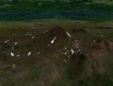
Meszah Peak is a volcanic cone
located 66 km (41 mi) north of Telegraph Creek and 136 km (85 mi) southwest of Zus Mountain. It is the highest mountain of the Level Mountain Range
, a massive shield volcano
forming the most voluminous and most persistent eruptive centre in the Northern Cordilleran Volcanic Province
.
Volcanic cone
Volcanic cones are among the simplest volcanic formations. They are built by ejecta from a volcanic vent, piling up around the vent in the shape of a cone with a central crater. Volcanic cones are of different types, depending upon the nature and size of the fragments ejected during the eruption...
located 66 km (41 mi) north of Telegraph Creek and 136 km (85 mi) southwest of Zus Mountain. It is the highest mountain of the Level Mountain Range
Level Mountain Range
The Level Mountain Range, also known as Level Mountain, is a mountain range in Cassiar Country, northwestern British Columbia, Canada, located just northeast of Callison Ranch, southwest of Dease Lake and about north of Mount Edziza. It consists of a massive shield volcano and lies on the Nahlin...
, a massive shield volcano
Shield volcano
A shield volcano is a type of volcano usually built almost entirely of fluid lava flows. They are named for their large size and low profile, resembling a warrior's shield. This is caused by the highly fluid lava they erupt, which travels farther than lava erupted from more explosive volcanoes...
forming the most voluminous and most persistent eruptive centre in the Northern Cordilleran Volcanic Province
Northern Cordilleran volcanic province
The Northern Cordilleran Volcanic Province , formerly known as the Stikine Volcanic Belt, is a geologic province defined by the occurrence of Miocene to Holocene volcanoes in the Pacific Northwest of North America...
.
See also
- List of volcanoes in Canada
- List of Northern Cordilleran volcanoes
- Volcanism of Canada
- Volcanism of Western CanadaVolcanism of Western CanadaVolcanism of Western Canada produces lava flows, lava plateaus, lava domes, cinder cones, stratovolcanoes, shield volcanoes, submarine volcanoes, calderas, diatremes and maars, along with examples of more less common volcanic forms such as tuyas and subglacial mounds.-Volcanic belts:*Anahim...
- Geography of CanadaGeography of CanadaThe geography of Canada is vast and diverse. Occupying most of the northern portion of North America , Canada is the world's second largest country in total area....
- Geography of British ColumbiaGeography of British ColumbiaBritish Columbia is the westernmost province of Canada, bordered by the Pacific Ocean. With an area of it is Canada's third-largest province. The province is nearly four times the size of Great Britain, two and one-half times larger than Japan and larger than every U.S. state except Alaska. It is...
- Geology of the Pacific NorthwestGeology of the Pacific NorthwestThe geology of the Pacific Northwest refers to the study of the composition , structure, physical properties and the processes that shape the Pacific Northwest region of the United States and Canada...
- Heart PeaksHeart PeaksHeart Peaks, originally known as the Heart Mountains, is a mountain massif in the Northern Interior of British Columbia, Canada. It is located northwest of the small community of Telegraph Creek and just southwest of Callison Ranch. With a maximum elevation of , it rises above the surrounding...
- Atsutla RangeAtsutla RangeThe Atsutla Range is a granitic mountain range on the Kawdy Plateau in northern British Columbia, Canada. The Atsutla Range lies south of the Yukon border in between Teslin Lake and the Stewart-Cassiar Highway, roughly north-northeast of Dease Lake....
External links
- Level Mountain in the Canadian Mountain Encyclopedia