
.gif)
Heart Mountain (Wyoming)
Encyclopedia
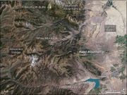
Heart Mountain is an 8,123-foot (2,476 m) klippe
just north of Cody
in the U.S. state
of Wyoming
, sticking up from the floor of the Bighorn Basin
. The mountain
is composed of limestone
and dolomite
of Ordovician
through Mississippian
age (about 500 to 350 million years old), but it rests on the Willwood Formation, rocks that are only about 55 million years old—rock on the summit of Heart Mountain is thus almost 300 million years older than the rocks at the base. For over one hundred years geologists have tried to understand how these older rocks came to rest on much younger strata.
The carbonate
rocks that form Heart Mountain were deposited on a basement of ancient (more than 2.5 billion years old) granite
when the area was covered by a large shallow tropical sea. Up until 50 million years ago, these rocks lay about 25 miles (40 kilometers) to the northwest, where the eastern Absaroka Range
now stands.
 Between 75 and 50 million years ago, a period of mountain-building called the Laramide Orogeny
caused uplift of the Beartooth Range and subsidence
of the Bighorn and Absaroka Basins. Just south of the Beartooth Range, this orogeny
uplifted an elongate, somewhat lower plateau which sloped gently to the southeast toward the Bighorn Basin and to the south toward the Absaroka Basin. Immediately following this period of mountain-building volcanic eruptions began to form the now extinct volcano
es of the Absaroka Range that lie to the south of the Beartooths and extend into Yellowstone National Park
. Between 50 and 48 million years ago a giant sheet of rock about 500 square miles (1,300 square kilometers) in area detached from the plateau south of the Beartooths and slid tens of kilometers to the southeast and south into the Bighorn and Absaroka Basins. This sheet, consisting of Ordovican through Mississippian carbonate rocks and overlying Absaroka volcanic rocks, was probably originally about 4-5 kilometers thick. Despite the slope being less than 2 degrees, the front of the landslide traveled at least 25 miles (40 km) and the slide mass ended up covering over 1,300 square miles (>3,400 km²). This is by far the largest rockslide
known on land on the surface of the earth and is comparable in scale to some of the largest known submarine landslides.
Many models have been proposed to explain what caused this huge slab of rocks to start sliding and what allowed it to slide so far on such a low slope, fragmenting, thinning and extending as it went. Most geologists who have worked in the area agree that Absaroka volcanism played a role in the sliding and many suggest that a major volcanic or steam explosion initiated movement. Another model involves injection of numerous igneous dike
s with the resulting heating of water within pores in rocks causing an increase in pressure which initiated sliding. Some geologists have suggested that hot pressurized water (hydrothermal fluids), derived from a volcano which sat north of Cooke City, Montana, effectively lubricated the sliding surface. Another possibility is that the once the slide was moving, friction
heated the limestone along the sliding surface, creating pseudotachylite
, which then further broke down to calcium oxide
and carbon dioxide
gas (or supercritical fluid
). The gas supported the slide in the way that air pressure supports a hovercraft
, allowing the slide to move easily down the very low slope. When the rockslide stopped, the carbon dioxide cooled and recombined with calcium oxide to form the cement-like carbonate rock now found in the fault zone. The consensus favors catastrophic sliding and calculations suggest that the front of the sliding mass may have advanced at a speed of over 100 miles/hour (160 km/h), meaning that the mountain traveled to its present location in approximately 30 minutes.
In the 48 million years since the slide occurred, erosion
has removed most of the portion of the slide sheet which moved out into the Bighorn Basin, leaving just one big block of carbonate rocks—Heart Mountain. Farther south, a large block of carbonate rock forms Sheep Mountain, which lies just south of the road that goes from Cody into Yellowstone Park. Some of the best views of the sliding surface, called the Heart Mountain fault, can be found along the Chief Joseph Highway (Wyoming Highway 296). The fault is particularly well exposed in Cathedral Cliffs, where it appears as a remarkably straight and nearly horizontal line just above a 2–3 meter high cliff.
The nearby Heart Mountain War Relocation Center
, where a number of Japanese American
s were interned
during World War II, was named after the peak.
Klippe
thumb|right|350px|Schematic overview of a thrust system. The shaded material is called a [[nappe]]. The erosional hole is called a [[window |window or fenster]]. The klippe is the isolated block of the nappe overlying autochthonous material....
just north of Cody
Cody, Wyoming
Cody is a city in Park County, Wyoming, United States. It is named after William Frederick Cody, primarily known as Buffalo Bill, from William Cody's part in the creation of the original town. The population was 9,520 at the 2010 census...
in the U.S. state
U.S. state
A U.S. state is any one of the 50 federated states of the United States of America that share sovereignty with the federal government. Because of this shared sovereignty, an American is a citizen both of the federal entity and of his or her state of domicile. Four states use the official title of...
of Wyoming
Wyoming
Wyoming is a state in the mountain region of the Western United States. The western two thirds of the state is covered mostly with the mountain ranges and rangelands in the foothills of the Eastern Rocky Mountains, while the eastern third of the state is high elevation prairie known as the High...
, sticking up from the floor of the Bighorn Basin
Bighorn Basin
The Bighorn Basin is a plateau region and intermontane basin, approximately 100 miles wide, in north-central Wyoming in the United States. It is bounded by the Absaroka Range on the west, the Bighorn Mountains on the east, and the Owl Creek Mountains and Bridger Mountains on the south...
. The mountain
Mountain
Image:Himalaya_annotated.jpg|thumb|right|The Himalayan mountain range with Mount Everestrect 58 14 160 49 Chomo Lonzorect 200 28 335 52 Makalurect 378 24 566 45 Mount Everestrect 188 581 920 656 Tibetan Plateaurect 250 406 340 427 Rong River...
is composed of limestone
Limestone
Limestone is a sedimentary rock composed largely of the minerals calcite and aragonite, which are different crystal forms of calcium carbonate . Many limestones are composed from skeletal fragments of marine organisms such as coral or foraminifera....
and dolomite
Dolomite
Dolomite is a carbonate mineral composed of calcium magnesium carbonate CaMg2. The term is also used to describe the sedimentary carbonate rock dolostone....
of Ordovician
Ordovician
The Ordovician is a geologic period and system, the second of six of the Paleozoic Era, and covers the time between 488.3±1.7 to 443.7±1.5 million years ago . It follows the Cambrian Period and is followed by the Silurian Period...
through Mississippian
Mississippian (geologic period)
The Mississippian is a subperiod in the geologic timescale or a subsystem of the geologic record. It is the earliest/lowermost of two subperiods of the Carboniferous period lasting from roughly 359 to 318 Ma...
age (about 500 to 350 million years old), but it rests on the Willwood Formation, rocks that are only about 55 million years old—rock on the summit of Heart Mountain is thus almost 300 million years older than the rocks at the base. For over one hundred years geologists have tried to understand how these older rocks came to rest on much younger strata.
The carbonate
Carbonate
In chemistry, a carbonate is a salt of carbonic acid, characterized by the presence of the carbonate ion, . The name may also mean an ester of carbonic acid, an organic compound containing the carbonate group C2....
rocks that form Heart Mountain were deposited on a basement of ancient (more than 2.5 billion years old) granite
Granite
Granite is a common and widely occurring type of intrusive, felsic, igneous rock. Granite usually has a medium- to coarse-grained texture. Occasionally some individual crystals are larger than the groundmass, in which case the texture is known as porphyritic. A granitic rock with a porphyritic...
when the area was covered by a large shallow tropical sea. Up until 50 million years ago, these rocks lay about 25 miles (40 kilometers) to the northwest, where the eastern Absaroka Range
Absaroka Range
The Absaroka Range is a sub-range of the Rocky Mountains in the United States. The range stretches about 150 mi across the Montana-Wyoming border, forming the eastern boundary of Yellowstone National Park and the western side of the Bighorn Basin. The range borders the Beartooth Mountains...
now stands.
Laramide orogeny
The Laramide orogeny was a period of mountain building in western North America, which started in the Late Cretaceous, 70 to 80 million years ago, and ended 35 to 55 million years ago. The exact duration and ages of beginning and end of the orogeny are in dispute, as is the cause. The Laramide...
caused uplift of the Beartooth Range and subsidence
Subsidence
Subsidence is the motion of a surface as it shifts downward relative to a datum such as sea-level. The opposite of subsidence is uplift, which results in an increase in elevation...
of the Bighorn and Absaroka Basins. Just south of the Beartooth Range, this orogeny
Orogeny
Orogeny refers to forces and events leading to a severe structural deformation of the Earth's crust due to the engagement of tectonic plates. Response to such engagement results in the formation of long tracts of highly deformed rock called orogens or orogenic belts...
uplifted an elongate, somewhat lower plateau which sloped gently to the southeast toward the Bighorn Basin and to the south toward the Absaroka Basin. Immediately following this period of mountain-building volcanic eruptions began to form the now extinct volcano
Volcano
2. Bedrock3. Conduit 4. Base5. Sill6. Dike7. Layers of ash emitted by the volcano8. Flank| 9. Layers of lava emitted by the volcano10. Throat11. Parasitic cone12. Lava flow13. Vent14. Crater15...
es of the Absaroka Range that lie to the south of the Beartooths and extend into Yellowstone National Park
Yellowstone National Park
Yellowstone National Park, established by the U.S. Congress and signed into law by President Ulysses S. Grant on March 1, 1872, is a national park located primarily in the U.S. state of Wyoming, although it also extends into Montana and Idaho...
. Between 50 and 48 million years ago a giant sheet of rock about 500 square miles (1,300 square kilometers) in area detached from the plateau south of the Beartooths and slid tens of kilometers to the southeast and south into the Bighorn and Absaroka Basins. This sheet, consisting of Ordovican through Mississippian carbonate rocks and overlying Absaroka volcanic rocks, was probably originally about 4-5 kilometers thick. Despite the slope being less than 2 degrees, the front of the landslide traveled at least 25 miles (40 km) and the slide mass ended up covering over 1,300 square miles (>3,400 km²). This is by far the largest rockslide
Rockslide
A rockslide is a type of landslide caused by rock failure in which part of the plane of failure passes through intact rock and where material collapses en masse and not in individual blocks.The mode of failure is different from that of a rock-fall....
known on land on the surface of the earth and is comparable in scale to some of the largest known submarine landslides.
Many models have been proposed to explain what caused this huge slab of rocks to start sliding and what allowed it to slide so far on such a low slope, fragmenting, thinning and extending as it went. Most geologists who have worked in the area agree that Absaroka volcanism played a role in the sliding and many suggest that a major volcanic or steam explosion initiated movement. Another model involves injection of numerous igneous dike
Dike (geology)
A dike or dyke in geology is a type of sheet intrusion referring to any geologic body that cuts discordantly across* planar wall rock structures, such as bedding or foliation...
s with the resulting heating of water within pores in rocks causing an increase in pressure which initiated sliding. Some geologists have suggested that hot pressurized water (hydrothermal fluids), derived from a volcano which sat north of Cooke City, Montana, effectively lubricated the sliding surface. Another possibility is that the once the slide was moving, friction
Friction
Friction is the force resisting the relative motion of solid surfaces, fluid layers, and/or material elements sliding against each other. There are several types of friction:...
heated the limestone along the sliding surface, creating pseudotachylite
Pseudotachylite
Pseudotachylite is a fault rock that has the appearance of the basaltic glass, tachylyte. It is dark in color and has a glassy appearance. However, the glass has normally been completely devitrified into very fine-grained material with radial and concentric clusters of crystals...
, which then further broke down to calcium oxide
Calcium oxide
Calcium oxide , commonly known as quicklime or burnt lime, is a widely used chemical compound. It is a white, caustic, alkaline crystalline solid at room temperature....
and carbon dioxide
Carbon dioxide
Carbon dioxide is a naturally occurring chemical compound composed of two oxygen atoms covalently bonded to a single carbon atom...
gas (or supercritical fluid
Supercritical fluid
A supercritical fluid is any substance at a temperature and pressure above its critical point, where distinct liquid and gas phases do not exist. It can effuse through solids like a gas, and dissolve materials like a liquid...
). The gas supported the slide in the way that air pressure supports a hovercraft
Hovercraft
A hovercraft is a craft capable of traveling over surfaces while supported by a cushion of slow moving, high-pressure air which is ejected against the surface below and contained within a "skirt." Although supported by air, a hovercraft is not considered an aircraft.Hovercraft are used throughout...
, allowing the slide to move easily down the very low slope. When the rockslide stopped, the carbon dioxide cooled and recombined with calcium oxide to form the cement-like carbonate rock now found in the fault zone. The consensus favors catastrophic sliding and calculations suggest that the front of the sliding mass may have advanced at a speed of over 100 miles/hour (160 km/h), meaning that the mountain traveled to its present location in approximately 30 minutes.
In the 48 million years since the slide occurred, erosion
Erosion
Erosion is when materials are removed from the surface and changed into something else. It only works by hydraulic actions and transport of solids in the natural environment, and leads to the deposition of these materials elsewhere...
has removed most of the portion of the slide sheet which moved out into the Bighorn Basin, leaving just one big block of carbonate rocks—Heart Mountain. Farther south, a large block of carbonate rock forms Sheep Mountain, which lies just south of the road that goes from Cody into Yellowstone Park. Some of the best views of the sliding surface, called the Heart Mountain fault, can be found along the Chief Joseph Highway (Wyoming Highway 296). The fault is particularly well exposed in Cathedral Cliffs, where it appears as a remarkably straight and nearly horizontal line just above a 2–3 meter high cliff.
The nearby Heart Mountain War Relocation Center
Heart Mountain War Relocation Center
The Heart Mountain Relocation Center, named after nearby Heart Mountain, was one of ten internment camps used to incarcerate Japanese Americans excluded from the West Coast during World War II under the provisions of Executive Order 9066 signed by President Franklin D. Roosevelt...
, where a number of Japanese American
Japanese American
are American people of Japanese heritage. Japanese Americans have historically been among the three largest Asian American communities, but in recent decades have become the sixth largest group at roughly 1,204,205, including those of mixed-race or mixed-ethnicity...
s were interned
Japanese American internment
Japanese-American internment was the relocation and internment by the United States government in 1942 of approximately 110,000 Japanese Americans and Japanese who lived along the Pacific coast of the United States to camps called "War Relocation Camps," in the wake of Imperial Japan's attack on...
during World War II, was named after the peak.