
June 2008 tornado outbreak sequence
Encyclopedia
The June 2008 tornado outbreak sequence was a series of tornado outbreak
s affecting most of central and eastern North America
from June 3–11, 2008. 192 tornado
es were confirmed, along with widespread straight–line wind
wind damage. Seven people were killed from a direct result of tornadoes; four in Iowa
, two in Kansas
, and one in Indiana
. Eleven additional people were killed across five states by other weather
events including lightning
, flash flood
ing, and straight-line winds. Severe flooding was also reported in much of Indiana
, Wisconsin
, Minnesota
and Iowa as a result of the same thunderstorm
s, while high heat and humidity
affected much of eastern North America; particularly along the eastern seaboard
of the United States from New York City to the Carolinas
.
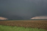
 Several clusters of thunderstorms developed during the morning from eastern Nebraska
across Iowa
into Illinois
, taking place along a warm front
. The front remained over the same areas during the day, as daytime heating and southwesterly surface winds brought warm and unstable air
northward, resulting in severe weather development. The presence of strong winds aloft aided in development of multiple clusters and lines of thunderstorms that produced damaging wind, hail and tornadoes across Missouri
, Illinois and Indiana
.
A moderate risk of severe weather
was issued by the Storm Prediction Center
for parts of Indiana, Kentucky
, Illinois, Ohio and West Virginia
on June 3, Two particular tornadoes, rated EF2 and EF3 on the Enhanced Fujita Scale
, caused extensive damage across portions of central Indiana. The EF3 tornado damaged 34 structures in Rush County
, of which 27 of them were in Middletown
. Eight people were injured in Rush County, including a 67-year-old woman who was impaled in the chest by a large tree limb and later died as a result of her injury on August 17. A nineteenth century landmark covered bridge in Moscow
was destroyed, as well as severe damage to dozens of homes, including some that were swept completely off the foundation. The EF2 tornado damaged 20 to 30 homes in Brown County
, 40 buildings at Camp Atterbury
in Johnson County
and 59 buildings in Edinburgh
.
into southern Nebraska
and from eastern West Virginia
through Virginia
, Maryland
and Delaware
. An ongoing line of thunderstorms moved east across West Virginia as the atmosphere began to destabilize. The thunderstorms resulted in a threat for isolated tornadoes in eastern sections of West Virginia, Virginia, Delaware and Maryland. In the central Great Plains
region, a warm front extended northeast in northeastern Kansas from a surface low in central sections of Kansas. Strong instability occurred in the vicinity of the area as a result of surface heating. An intensifying low-level jet stream
broke the cap
in the region and resulted in the development of thunderstorms. During the afternoon, numerous thunderstorms formed across the Mid-Atlantic States
. An EF0 tornado was produced from one of the thunderstorms that impacted portions of Chesapeake Beach
, tearing off sections of roof and siding from 10 to 20 single family homes. EF1 tornadoes were produced in Culpeper
, Clarke
and Stafford
counties in Virginia. Several other EF0 and EF1 tornadoes formed throughout the Great Plains region.
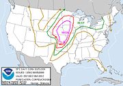 A strong jet stream moved northeast across the Great Plains region and a strong surface low in western Kansas strengthened as it moved to the Nebraska-South Dakota
border. Ahead of the low, very warm and moist air spread throughout the South Central United States
into Nebraska, eastern sections of South Dakota and the upper Mississippi Valley. The combination of strong winds and warm and moist air created conditions favorable for strong thunderstorms. On June 5, a high risk of severe weather was issued for six different states in the Midwestern United States
, with a moderate risk area surrounding the high risk area. Forecasters had warned of a potentially historic outbreak, as computer forecasting models for June 5 resembled those on June 8, 1974, when 39 tornadoes struck the southern Great Plains and killed 22 people. Wichita State University
canceled evening classes because of the weather predictions. Severe weather began developing across eastern Colorado
and northwestern Kansas during the morning and into the early afternoon, producing several weak tornadoes in the process. An EF1 tornado impacted a campground near Kellogg, Iowa
and injured two people. Despite extremely favorable conditions, severe weather for the day was limited and the tornadoes generally caused minimal damage.
 During the morning hours of June 6, Two violent tornadoes caused damage throughout Wadena
and Hubbard
counties in Minnesota
. The first tornado, rated EF2 on the Enhanced Fujita Scale, touched down south of Stocking Lake and downed several trees onto cabins, vehicles and storage sheds. It also toppled a irrigation system in a field north of the lake. The tornado moved to the north and expanded to its maximum width of 450 yards (411.5 m) and reached estimated peak winds of 130 miles per hour (209.2 km/h). Eight turkey barns were destroyed, killing an estimated 15 to 20 thousand turkeys. The tornado swept a home north of the area in Hubbard County off its foundation, as well as causing damage to several homes along with hundreds of acres of forest. One man working at a turkey barn was injured. The storm then produced an EF3 tornado, which eventually grew to a width of 400 yards (365.8 m) and reached wind speeds of 160 miles per hour (257.5 km/h). At Pickerel Lake, it nearly flattened every tree in the area, while destroying a trailer home, a camper, a garage and a house. At northern sections of Pickerel Lake, one home had its roof torn off and numerous trees were snapped onto other residences and farm buildings. The tornado began to lose its intensity but continued to topple trees, damage storage structures and toss debris before dissipating in Emmaville
.
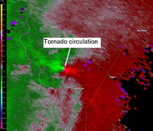
into the central Great Plains. Opulent moisture formed over the Missouri and Mississippi Valleys with dew point
s reaching near 70 °F (21.1 °C). Strong low level winds over the area created favorable wind shear for supercell
s. During the afternoon, a supercell developed in western portions of Illinois and moved northeast reaching Lake Michigan
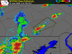
around the Illinois-Indiana border, during which it produced eight tornadoes along its path. At 4:21 pm (2121 UTC), an EF0 tornado occurred 4 miles (6.4 km) east of Cornell
in Livingston County
. The tornado occurred in an open field with no damage observed. At 4:31 pm CDT (2131 UTC), an EF1 tornado touched down southwest of Dwight
in Livingston County, snapping power poles and damaging trees and roofs; this tornado lifted at 4:45 pm CDT (2145 UTC). From 5:18 pm CDT (2218 UTC) to 5:46 pm CDT (2246 UTC), an EF2 tornado traveled 13.6 miles (21.9 km) across southwestern Will County
and extreme northwestern Kankakee County
, near Wilmington
, uprooting trees, damaging homes and destroying sheds. At 5:51 pm CDT (2251 UTC), an EF2 tornado touched down for three minutes in central Will County near Wilton Center, destroying a garage and severely damaging a metal building. From 5:55 pm CDT (2255 UTC) to 6:08 pm CDT (2308 UTC), an EF2 tornado occurred west of Monee
, leveling barns, garages, and outbuildings and damaging homes. An EF2 tornado re-formed at 6:13 pm CDT (2313 UTC), injuring six people as it crossed Interstate 57
.
 As the tornado moved into more densely populated southern Cook County
, it destroyed homes in Richton Park
, before dissipating at 6:30 pm CDT (2330 UTC). At approximately 6:32 pm CDT (2332 UTC), an EF0 tornado hit South Chicago Heights
, causing minor damage to several homes, with two homes sustaining significant damage. At 6:49 pm CDT (2349 UTC), an EF0 tornado touched down in Lansing
, damaging tree limbs. In Wisconsin, five people suffered minor injuries after an EF2 tornado went through Columbia County
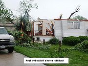
. Further west, a new complex of storms produced two tornadoes inside the Omaha metropolitan area
during the early hours of June 8. A total of 539 homeowners reported damage from the tornadoes. Seven homes were destroyed and 21 others sustained major damage. The two tornadoes that hit the region were rated EF1 and EF2. The EF2 tornado was the strongest to strike the Omaha metropolitan area since 1975
.
northward ahead of the system. Thunderstorms developed during the afternoon ahead of a cold front from southeast South Dakota into central Kansas. Strong winds along with instability in the atmosphere created favorable conditions for supercell development with the potential to produce strong tornadoes. At approximately 6:35 pm CDT (2335 UTC) a tornado hit the Little Sioux Scout Ranch
in Little Sioux, Iowa
, killing four Boy Scouts
after a chimney collapsed on them and injuring 48 others. The camp received a tornado warning
12 minutes before it struck. There were 93 campers and 25 staff members at the camp. The campers were between 13 and 18-years-old and were attending a leadership training camp. The tornado was rated EF3 on the Enhanced Fujita Scale.
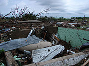
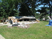
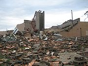 Tornadoes also caused major damage in Kansas. In Chapman
, one person was killed and three others were critically injured after an EF3 tornado struck the town. About 80 percent of Chapman suffered serious damage, with minor damage occurring to the downtown area. 70 homes in Chapman were destroyed with 215 receiving damage. Two churches were demolished and the town's elementary, middle and high schools were severely damaged. Manhattan
was also heavily impacted by a tornado that was rated EF4 on the Enhanced Fujita Scale. Forty-five residences in Manhattan were destroyed, as well as two mobile homes and three businesses. An additional 67 residences, three multi-family homes, one mobile home and 10 businesses suffered significant damage. Also, 75 single-family residences, three multi-family structures and 20 businesses sustained minor damage, and 637 residences, 93 multi-family structures, 20 mobile homes and 10 businesses were partially affected. An elementary school was also heavily damaged in Manhattan. There was also damage to Kansas State University
, where the Wind Erosion Lab was damaged. Also suffering severe damage was the engineering complex, the Sigma Alpha Epsilon
fraternity house, Waters, Call and Cardwell halls as well as Ward Hall, which houses the university's nuclear reactor. One person was also killed near the town of Soldier
in Jackson County
from an EF2 tornado. 32 homes were damaged in Jackson County. The southern outskirts of Salina
near the junction of Interstate 135
was also hard hit by an EF3 tornado. Several homes, outbuildings, trees and power lines were damaged in the area.
was struck by lightning, damaging computers for the 911 system and the sheriff's office, radio consoles, and various other electronic equipment. In Oklahoma
, high winds in excess of 80 miles per hour (128.7 km/h) caused major damage to five to six barns in Cherokee
and destroyed one barn in Ingersoll
. Three people were injured in Frontenac, Kansas
after a tree was blown down on a vehicle. The next day, the inclement weather moved into the Mid-Atlantic States
. A 57-year-old man was killed in Annandale, Virginia
after a large tree crushed his vehicle. More than 250,000 customers lost power in Virginia. Washington Monument State Park suffered extensive damage after thunderstorms knocked out phone, electricity, and water service. Fallen trees and branches blocked the main road and the hiking trail to the monument in several places. The museum and water treatment buildings were severely damaged, and as a result, the park was closed for two weeks. A total 70 severe thunderstorm, marine, and tornado warnings were issued in the Baltimore/Washington region. In Bloomington, Indiana
, two people had lightning strikes near them and were taken to the hospital for lighting related injuries. The cell phone of another individual was stuck while the person was talking on the phone and was also taken to the hospital for treatment.
On June 5, a storm system caused damage throughout the Great Plains. The most substantial damage occurred in Altus, Oklahoma
, where 179 homes sustained some form of damage, with two destroyed, five with major damage, 43 with minor damage and 129 affected. Seventeen businesses were damaged, with two destroyed, four with major damage and eight with minor damage. A school in Mulvane, Kansas
had roof damage and there was significant roof damage to the terminal building at an airport near Winfield
. In Lawrence
, The Wakarusa Music and Camping Festival
shut down while the storm passed through. On June 8, thunderstorms affected areas across the Great Lakes
region. Two people were killed in Ottawa County, Michigan
due to the straight-line winds that toppled trees; one onto a pedestrian and another onto a car. In Eaton County
, a woman was killed by winds which blew a large trailer on to her. Over 300,000 people in Michigan were left without power due to the storm.
 On June 10, a powerful squall line of thunderstorms with embedded supercell
s developed across New York and moved northeast through parts of northern New England
and Quebec
. Particularly hard hit was the Montreal
region and its southern suburbs including Longueuil
, Châteauguay, Brossard
and Saint-Jean-sur-Richelieu. Barns were reported damaged and other structures sustained roof and siding damage; particularly in the Saint-Blaise-sur-Richelieu
area where one home was pushed from its foundation. In Sainte-Catherine
, the roof of an office was blown into a nearby residence punching a large hole on the back wall. On Montreal's Champlain Bridge
, eight tractor trailers were overturned forcing the closure of the entire bridge in both directions. In addition, a window washing platform tumbled from a high rise building in downtown Montreal. The workers were able to get inside.
 Severe thunderstorms also affected the Saint-Hyacinthe
, Sherbrooke, Trois-Rivières
and Quebec City
where winds as strong as 68 miles per hour (109 km/h) were reported with locally higher gusts while hail from golf ball
to baseball
size were reported in Mont-Saint-Hilaire
and Belœil breaking windows from homes and vehicles. The roof of a 65 unit apartment complex in Sainte-Foy
was heavily damaged. The Quebec Bridge
linking the city to the suburb of Levis
was also temporarily shut down because of a collapsed scaffolding. About 300,000 Hydro-Québec
customers across the province lost power, particularly in the Quebec City, Montérégie
and Montreal regions with outages occurring in the Eastern Townships
and Mauricie
regions. Schools in some areas were closed on June 11 due to the power outages. The tractor trailer accidents resulted in two minor injuries during the storms. According to a report from the Insurance Bureau of Canada, insured damage amounts were estimated at $56 million (2008 CAD
), and up to 16,000 insurance claims were filed for damage to homes and automobiles.
The severe weather extended south into the Eastern Seaboard of the United States where it ended a prolonged period of intense heat. Temperatures had reached the mid to upper 90s °F (mid 30s °C) for several days in a row, with some areas exceeding 100 °F (37.8 °C). About 150,000 customers in New Jersey
, 140,000 in Pennsylvania
and 50,000 in northern New York
lost power. One person was killed in Lewis County, New York
by fallen trees during the storm.
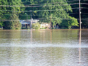
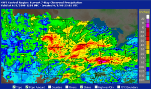 The same series of systems contributed to a significant flooding event in many parts of the Midwest. Several counties in this region in Iowa, Illinois and Wisconsin were declared disaster areas. Over 10 inches (25.4 cm) fell in areas over the course of a week, and in Indiana some rivers approached levels similar to flooding in 1913 which killed 200 people. In Franklin, Indiana
, water at one point reached the first level of the area hospital, and buildings at Franklin College were damaged. Flooding was reported also in Columbus
, Helmsburg
and Terre Haute, Indiana
. US Coast Guard units were deployed in assistance for rescue efforts. Parts of Interstate 65
and US Route 31 were temporarily shut down. Thirty thousand people in Indiana lost power during the storms, and several counties filed disaster declarations.
 Beginning on June 8, flooding also started occurring across parts of Iowa following several round of thunderstorms and heavy rains. In Parkersburg, Iowa
, a levee burst, flooding three nearby highways. In New Hartford
, which was also hit by the same tornado, water gushed over a levee forcing the evacuation of 650 people. The flood waters also damaged a water treatment plant leaving Mason City
without drinking water. Up to 5 inches (12.7 cm) of rain fell in parts of the state. Mandatory evacuations were also made in Cedar Falls
and Waterloo
. Several entire blocks in Cedar Rapids
were under water (which was at times as high as stop signs) after the Cedar River overflowed its banks. Flooding later affected the Iowa City
area along the Iowa River
where 20 buildings on the University of Iowa
campus were affected. Many other towns across the state became flooded as well as the rising water levels slowly made their way into the Mississippi River
across southeastern Iowa, western Illinois and northeastern Missouri.
Flooding was also reported north of Mason City in southeastern Minnesota, where several inches of rain closed roads and forced evacuations. Gays Mills, Wisconsin
was evacuated for the second time in ten months when the Kickapoo River
flooded the town. These same areas were also affected by the 2007 Midwest flooding
. From June 3 to June 11 eight people were killed due to flooding; three in Indiana, three in Michigan, and one in Illinois and Minnesota.
Tornado outbreak
While there is no single agreed upon definition, generally at least 6-10 tornadoes produced by the same synoptic scale weather system is considered a tornado outbreak. The tornadoes usually occur within the same day, or continue into the early morning hours of the succeeding day, and within the...
s affecting most of central and eastern North America
North America
North America is a continent wholly within the Northern Hemisphere and almost wholly within the Western Hemisphere. It is also considered a northern subcontinent of the Americas...
from June 3–11, 2008. 192 tornado
Tornado
A tornado is a violent, dangerous, rotating column of air that is in contact with both the surface of the earth and a cumulonimbus cloud or, in rare cases, the base of a cumulus cloud. They are often referred to as a twister or a cyclone, although the word cyclone is used in meteorology in a wider...
es were confirmed, along with widespread straight–line wind
Downburst
A downburst is created by an area of significantly rain-cooled air that, after reaching ground level, spreads out in all directions producing strong winds. Unlike winds in a tornado, winds in a downburst are directed outwards from the point where it hits land or water...
wind damage. Seven people were killed from a direct result of tornadoes; four in Iowa
Iowa
Iowa is a state located in the Midwestern United States, an area often referred to as the "American Heartland". It derives its name from the Ioway people, one of the many American Indian tribes that occupied the state at the time of European exploration. Iowa was a part of the French colony of New...
, two in Kansas
Kansas
Kansas is a US state located in the Midwestern United States. It is named after the Kansas River which flows through it, which in turn was named after the Kansa Native American tribe, which inhabited the area. The tribe's name is often said to mean "people of the wind" or "people of the south...
, and one in Indiana
Indiana
Indiana is a US state, admitted to the United States as the 19th on December 11, 1816. It is located in the Midwestern United States and Great Lakes Region. With 6,483,802 residents, the state is ranked 15th in population and 16th in population density. Indiana is ranked 38th in land area and is...
. Eleven additional people were killed across five states by other weather
Weather
Weather is the state of the atmosphere, to the degree that it is hot or cold, wet or dry, calm or stormy, clear or cloudy. Most weather phenomena occur in the troposphere, just below the stratosphere. Weather refers, generally, to day-to-day temperature and precipitation activity, whereas climate...
events including lightning
Lightning
Lightning is an atmospheric electrostatic discharge accompanied by thunder, which typically occurs during thunderstorms, and sometimes during volcanic eruptions or dust storms...
, flash flood
Flash flood
A flash flood is a rapid flooding of geomorphic low-lying areas—washes, rivers, dry lakes and basins. It may be caused by heavy rain associated with a storm, hurricane, or tropical storm or meltwater from ice or snow flowing over ice sheets or snowfields...
ing, and straight-line winds. Severe flooding was also reported in much of Indiana
Indiana
Indiana is a US state, admitted to the United States as the 19th on December 11, 1816. It is located in the Midwestern United States and Great Lakes Region. With 6,483,802 residents, the state is ranked 15th in population and 16th in population density. Indiana is ranked 38th in land area and is...
, Wisconsin
Wisconsin
Wisconsin is a U.S. state located in the north-central United States and is part of the Midwest. It is bordered by Minnesota to the west, Iowa to the southwest, Illinois to the south, Lake Michigan to the east, Michigan to the northeast, and Lake Superior to the north. Wisconsin's capital is...
, Minnesota
Minnesota
Minnesota is a U.S. state located in the Midwestern United States. The twelfth largest state of the U.S., it is the twenty-first most populous, with 5.3 million residents. Minnesota was carved out of the eastern half of the Minnesota Territory and admitted to the Union as the thirty-second state...
and Iowa as a result of the same thunderstorm
Thunderstorm
A thunderstorm, also known as an electrical storm, a lightning storm, thundershower or simply a storm is a form of weather characterized by the presence of lightning and its acoustic effect on the Earth's atmosphere known as thunder. The meteorologically assigned cloud type associated with the...
s, while high heat and humidity
Humidity
Humidity is a term for the amount of water vapor in the air, and can refer to any one of several measurements of humidity. Formally, humid air is not "moist air" but a mixture of water vapor and other constituents of air, and humidity is defined in terms of the water content of this mixture,...
affected much of eastern North America; particularly along the eastern seaboard
East Coast of the United States
The East Coast of the United States, also known as the Eastern Seaboard, refers to the easternmost coastal states in the United States, which touch the Atlantic Ocean and stretch up to Canada. The term includes the U.S...
of the United States from New York City to the Carolinas
The Carolinas
The Carolinas is a term used in the United States to refer collectively to the states of North and South Carolina. Together, the two states + have a population of 13,942,126. "Carolina" would be the fifth most populous state behind California, Texas, New York, and Florida...
.
June 3
Nebraska
Nebraska is a state on the Great Plains of the Midwestern United States. The state's capital is Lincoln and its largest city is Omaha, on the Missouri River....
across Iowa
Iowa
Iowa is a state located in the Midwestern United States, an area often referred to as the "American Heartland". It derives its name from the Ioway people, one of the many American Indian tribes that occupied the state at the time of European exploration. Iowa was a part of the French colony of New...
into Illinois
Illinois
Illinois is the fifth-most populous state of the United States of America, and is often noted for being a microcosm of the entire country. With Chicago in the northeast, small industrial cities and great agricultural productivity in central and northern Illinois, and natural resources like coal,...
, taking place along a warm front
Warm front
A warm front is a density discontinuity located at the leading edge of a homogeneous warm air mass, and is typically located on the equator-facing edge of an isotherm gradient...
. The front remained over the same areas during the day, as daytime heating and southwesterly surface winds brought warm and unstable air
Atmospheric instability
Atmospheric instability is a condition where the atmosphere is generally considered to be unstable and as a result the weather is subject to a high degree of variability through distance and time...
northward, resulting in severe weather development. The presence of strong winds aloft aided in development of multiple clusters and lines of thunderstorms that produced damaging wind, hail and tornadoes across Missouri
Missouri
Missouri is a US state located in the Midwestern United States, bordered by Iowa, Illinois, Kentucky, Tennessee, Arkansas, Oklahoma, Kansas and Nebraska. With a 2010 population of 5,988,927, Missouri is the 18th most populous state in the nation and the fifth most populous in the Midwest. It...
, Illinois and Indiana
Indiana
Indiana is a US state, admitted to the United States as the 19th on December 11, 1816. It is located in the Midwestern United States and Great Lakes Region. With 6,483,802 residents, the state is ranked 15th in population and 16th in population density. Indiana is ranked 38th in land area and is...
.
A moderate risk of severe weather
Severe weather
Severe weather phenomena are weather conditions that are hazardous to human life and property.- Examples Include :Severe weather can occur under a variety of situations, but three characteristics are generally needed: a temperature or moisture boundary, moisture, and , instability in the...
was issued by the Storm Prediction Center
Storm Prediction Center
The Storm Prediction Center , located in Norman, Oklahoma, is tasked with forecasting the risk of severe thunderstorms and tornadoes in the contiguous United States. The agency issues convective outlooks, mesoscale discussions, and watches as a part of this process...
for parts of Indiana, Kentucky
Kentucky
The Commonwealth of Kentucky is a state located in the East Central United States of America. As classified by the United States Census Bureau, Kentucky is a Southern state, more specifically in the East South Central region. Kentucky is one of four U.S. states constituted as a commonwealth...
, Illinois, Ohio and West Virginia
West Virginia
West Virginia is a state in the Appalachian and Southeastern regions of the United States, bordered by Virginia to the southeast, Kentucky to the southwest, Ohio to the northwest, Pennsylvania to the northeast and Maryland to the east...
on June 3, Two particular tornadoes, rated EF2 and EF3 on the Enhanced Fujita Scale
Enhanced Fujita Scale
The Enhanced Fujita Scale rates the strength of tornadoes in the United States based on the damage they cause.Implemented in place of the Fujita scale introduced in 1971 by Ted Fujita, it began operational use on February 1, 2007. The scale has the same basic design as the original Fujita scale:...
, caused extensive damage across portions of central Indiana. The EF3 tornado damaged 34 structures in Rush County
Rush County, Indiana
As of the census of 2000, there were 18,261 people, 6,923 households, and 5,046 families residing in the county. The population density was 45 people per square mile . There were 7,337 housing units at an average density of 18 per square mile...
, of which 27 of them were in Middletown
Middletown, Indiana
Middletown is a town in northwest Henry County, Indiana, United States. The population was 2,322 at the 2010 census.-Geography:Middletown is located at ....
. Eight people were injured in Rush County, including a 67-year-old woman who was impaled in the chest by a large tree limb and later died as a result of her injury on August 17. A nineteenth century landmark covered bridge in Moscow
Moscow, Indiana
Moscow is an unincorporated town in Orange Township, Rush County, Indiana. The town of approximately 80 residents was struck on June 3, 2008 by an EF3 tornado which destroyed its landmark 19th century covered bridge over the Big Flatrock river....
was destroyed, as well as severe damage to dozens of homes, including some that were swept completely off the foundation. The EF2 tornado damaged 20 to 30 homes in Brown County
Brown County, Indiana
Brown County is a county located in the U.S. state of Indiana. As of 2010, the population is 15,242. The county seat is Nashville.- History :...
, 40 buildings at Camp Atterbury
Camp Atterbury
Camp Atterbury, near Edinburgh, Indiana, USA, is a training base of the Indiana National Guard. It was planned just months before the U.S. entry into World War II. Originally surveyed and researched by the Hurd Company, the present site was recommended to Congress in 1941. Construction commenced...
in Johnson County
Johnson County, Indiana
As of the census of 2000, there were 115,209 people, 42,434 households, and 31,613 families residing in the county. The population density was 360 people per square mile . There were 45,095 housing units at an average density of 141 per square mile...
and 59 buildings in Edinburgh
Edinburgh, Indiana
Edinburgh is a town in Bartholomew, Johnson, and Shelby Counties in the U.S. state of Indiana. The population was 4,480 at the 2010 census. It is part of the Columbus, Indiana metropolitan statistical area. Edinburgh was named in honor of Edinburgh, Scotland and for many years was pronounced the...
.
June 4
A moderate risk of severe weather was issued for northern KansasKansas
Kansas is a US state located in the Midwestern United States. It is named after the Kansas River which flows through it, which in turn was named after the Kansa Native American tribe, which inhabited the area. The tribe's name is often said to mean "people of the wind" or "people of the south...
into southern Nebraska
Nebraska
Nebraska is a state on the Great Plains of the Midwestern United States. The state's capital is Lincoln and its largest city is Omaha, on the Missouri River....
and from eastern West Virginia
West Virginia
West Virginia is a state in the Appalachian and Southeastern regions of the United States, bordered by Virginia to the southeast, Kentucky to the southwest, Ohio to the northwest, Pennsylvania to the northeast and Maryland to the east...
through Virginia
Virginia
The Commonwealth of Virginia , is a U.S. state on the Atlantic Coast of the Southern United States. Virginia is nicknamed the "Old Dominion" and sometimes the "Mother of Presidents" after the eight U.S. presidents born there...
, Maryland
Maryland
Maryland is a U.S. state located in the Mid Atlantic region of the United States, bordering Virginia, West Virginia, and the District of Columbia to its south and west; Pennsylvania to its north; and Delaware to its east...
and Delaware
Delaware
Delaware is a U.S. state located on the Atlantic Coast in the Mid-Atlantic region of the United States. It is bordered to the south and west by Maryland, and to the north by Pennsylvania...
. An ongoing line of thunderstorms moved east across West Virginia as the atmosphere began to destabilize. The thunderstorms resulted in a threat for isolated tornadoes in eastern sections of West Virginia, Virginia, Delaware and Maryland. In the central Great Plains
Great Plains
The Great Plains are a broad expanse of flat land, much of it covered in prairie, steppe and grassland, which lies west of the Mississippi River and east of the Rocky Mountains in the United States and Canada. This area covers parts of the U.S...
region, a warm front extended northeast in northeastern Kansas from a surface low in central sections of Kansas. Strong instability occurred in the vicinity of the area as a result of surface heating. An intensifying low-level jet stream
Jet stream
Jet streams are fast flowing, narrow air currents found in the atmospheres of some planets, including Earth. The main jet streams are located near the tropopause, the transition between the troposphere and the stratosphere . The major jet streams on Earth are westerly winds...
broke the cap
Capping inversion
A capping inversion is an elevated inversion layer that caps a convective boundary layer.The boundary layer is the part of the atmosphere which is closest to the ground. Normally, the sun heats the ground, which in turn heats the air just above it. Thermals form when this warm air rises into the...
in the region and resulted in the development of thunderstorms. During the afternoon, numerous thunderstorms formed across the Mid-Atlantic States
Mid-Atlantic States
The Mid-Atlantic states, also called middle Atlantic states or simply the mid Atlantic, form a region of the United States generally located between New England and the South...
. An EF0 tornado was produced from one of the thunderstorms that impacted portions of Chesapeake Beach
Chesapeake Beach, Maryland
Chesapeake Beach is a town in Calvert County, Maryland, United States. Its major attractions include a Railway Museum & Trail, the Chesapeake Beach Water Park, marinas, piers, charter boat fishing, and a Veterans Memorial Park...
, tearing off sections of roof and siding from 10 to 20 single family homes. EF1 tornadoes were produced in Culpeper
Culpeper County, Virginia
As of the census of 2000, there were 34,262 people, 12,141 households, and 9,045 families residing in the county. The population density was 90 people per square mile . There were 12,871 housing units at an average density of 34 per square mile...
, Clarke
Clarke County, Virginia
Clarke County is a county in the Commonwealth of Virginia. As of 2010, the population was 14,034. Its county seat is Berryville.-History:Clarke County was established in 1836 by Thomas Fairfax, 6th Lord Fairfax of Cameron who built a home, Greenway Court, on part of his 5 million acre property,...
and Stafford
Stafford County, Virginia
Stafford County is a county located in the Commonwealth of Virginia, a U.S. state, and just across the Rappahannock River from the City of Fredericksburg. As of the 2000 census, the population was 92,446, increasing to 128,961 in 2010.. Its county seat is Stafford. In 2006, and again in 2009,...
counties in Virginia. Several other EF0 and EF1 tornadoes formed throughout the Great Plains region.
June 5
South Dakota
South Dakota is a state located in the Midwestern region of the United States. It is named after the Lakota and Dakota Sioux American Indian tribes. Once a part of Dakota Territory, South Dakota became a state on November 2, 1889. The state has an area of and an estimated population of just over...
border. Ahead of the low, very warm and moist air spread throughout the South Central United States
South Central United States
The South Central United States or South Central states is a region of the United States located in the south central part of the country. It evolved out of the archaic southwest, which originally was literally the western U.S. South...
into Nebraska, eastern sections of South Dakota and the upper Mississippi Valley. The combination of strong winds and warm and moist air created conditions favorable for strong thunderstorms. On June 5, a high risk of severe weather was issued for six different states in the Midwestern United States
Midwestern United States
The Midwestern United States is one of the four U.S. geographic regions defined by the United States Census Bureau, providing an official definition of the American Midwest....
, with a moderate risk area surrounding the high risk area. Forecasters had warned of a potentially historic outbreak, as computer forecasting models for June 5 resembled those on June 8, 1974, when 39 tornadoes struck the southern Great Plains and killed 22 people. Wichita State University
Wichita State University
Wichita State University is a NCAA Division I public university in Wichita, Kansas with selective admissions. WSU is one of six state universities governed by the Kansas Board of Regents. The current president is Dr. Donald Beggs....
canceled evening classes because of the weather predictions. Severe weather began developing across eastern Colorado
Colorado
Colorado is a U.S. state that encompasses much of the Rocky Mountains as well as the northeastern portion of the Colorado Plateau and the western edge of the Great Plains...
and northwestern Kansas during the morning and into the early afternoon, producing several weak tornadoes in the process. An EF1 tornado impacted a campground near Kellogg, Iowa
Kellogg, Iowa
Kellogg is a city in Jasper County, Iowa, United States. The population was 606 at the 2000 census.-History:Kellogg was formed in September 1865. The railroad reached the town in 1866 and it was designated a station on the line...
and injured two people. Despite extremely favorable conditions, severe weather for the day was limited and the tornadoes generally caused minimal damage.
June 6
Wadena County, Minnesota
As of the census of 2000, there were 13,713 people, 5,426 households, and 3,608 families residing in the county. The population density was 26 people per square mile . There were 6,334 housing units at an average density of 12 per square mile...
and Hubbard
Hubbard County, Minnesota
As of the census of 2000, there were 18,376 people, 7,435 households, and 5,345 families residing in the county. The population density was 20 people per square mile . There were 12,229 housing units at an average density of 13 per square mile...
counties in Minnesota
Minnesota
Minnesota is a U.S. state located in the Midwestern United States. The twelfth largest state of the U.S., it is the twenty-first most populous, with 5.3 million residents. Minnesota was carved out of the eastern half of the Minnesota Territory and admitted to the Union as the thirty-second state...
. The first tornado, rated EF2 on the Enhanced Fujita Scale, touched down south of Stocking Lake and downed several trees onto cabins, vehicles and storage sheds. It also toppled a irrigation system in a field north of the lake. The tornado moved to the north and expanded to its maximum width of 450 yards (411.5 m) and reached estimated peak winds of 130 miles per hour (209.2 km/h). Eight turkey barns were destroyed, killing an estimated 15 to 20 thousand turkeys. The tornado swept a home north of the area in Hubbard County off its foundation, as well as causing damage to several homes along with hundreds of acres of forest. One man working at a turkey barn was injured. The storm then produced an EF3 tornado, which eventually grew to a width of 400 yards (365.8 m) and reached wind speeds of 160 miles per hour (257.5 km/h). At Pickerel Lake, it nearly flattened every tree in the area, while destroying a trailer home, a camper, a garage and a house. At northern sections of Pickerel Lake, one home had its roof torn off and numerous trees were snapped onto other residences and farm buildings. The tornado began to lose its intensity but continued to topple trees, damage storage structures and toss debris before dissipating in Emmaville
Emmaville, Minnesota
Emmaville is a small unincorporated community in Hubbard County, Minnesota, United States. The community is located at the intersection of County Roads 4 and 24 just in between Park Rapids and Lake George and features a gas station, convenience store and cafe...
.
June 7–8
A series of impulses moved from the central Rocky MountainsRocky Mountains
The Rocky Mountains are a major mountain range in western North America. The Rocky Mountains stretch more than from the northernmost part of British Columbia, in western Canada, to New Mexico, in the southwestern United States...
into the central Great Plains. Opulent moisture formed over the Missouri and Mississippi Valleys with dew point
Dew point
The dew point is the temperature to which a given parcel of humid air must be cooled, at constant barometric pressure, for water vapor to condense into liquid water. The condensed water is called dew when it forms on a solid surface. The dew point is a saturation temperature.The dew point is...
s reaching near 70 °F (21.1 °C). Strong low level winds over the area created favorable wind shear for supercell
Supercell
A supercell is a thunderstorm that is characterized by the presence of a mesocyclone: a deep, continuously-rotating updraft. For this reason, these storms are sometimes referred to as rotating thunderstorms...
s. During the afternoon, a supercell developed in western portions of Illinois and moved northeast reaching Lake Michigan
Lake Michigan
Lake Michigan is one of the five Great Lakes of North America and the only one located entirely within the United States. It is the second largest of the Great Lakes by volume and the third largest by surface area, after Lake Superior and Lake Huron...
around the Illinois-Indiana border, during which it produced eight tornadoes along its path. At 4:21 pm (2121 UTC), an EF0 tornado occurred 4 miles (6.4 km) east of Cornell
Cornell, Illinois
Cornell is a village in Livingston County, Illinois, United States. The population was 511 at the 2000 census. It is a part of the geographic region known as Streatorland.-Geography:Cornell is located at ....
in Livingston County
Livingston County, Illinois
Livingston County is a county located in the U.S. state of Illinois. According to the 2010 census, it has a population of 38,950, which is a decrease of 1.8% from 39,678 in 2000. Its county seat is Pontiac....
. The tornado occurred in an open field with no damage observed. At 4:31 pm CDT (2131 UTC), an EF1 tornado touched down southwest of Dwight
Dwight, Illinois
Dwight is a village in located mainly in Livingston County, Illinois, with a small portion in Grundy County, Illinois. The population was 4,260 at the 2010 census. Dwight contains an original stretch of the famous U.S. Route 66, and uses a railroad station designed in 1891 by Henry Ives Cobb. It is...
in Livingston County, snapping power poles and damaging trees and roofs; this tornado lifted at 4:45 pm CDT (2145 UTC). From 5:18 pm CDT (2218 UTC) to 5:46 pm CDT (2246 UTC), an EF2 tornado traveled 13.6 miles (21.9 km) across southwestern Will County
Will County, Illinois
As of the census of 2000, there were 502,266 people, 167,542 households, and 131,017 families residing in the county. The population density was 600 people per square mile . There were 175,524 housing units at an average density of 210 per square mile...
and extreme northwestern Kankakee County
Kankakee County, Illinois
Kankakee County is a county located in the U.S. state of Illinois. According to the 2010 census, it has a population of 113,449, which is an increase of 9.3% from 103,833 in 2000. Its county seat is Kankakee....
, near Wilmington
Wilmington, Will County, Illinois
One of Wilmington's most notable geographical features is a large island in the Kankakee River, much of which is occupied by a city park. This island divides the river into a large channel and a smaller one which was used as a natural mill race during the early years of the city...
, uprooting trees, damaging homes and destroying sheds. At 5:51 pm CDT (2251 UTC), an EF2 tornado touched down for three minutes in central Will County near Wilton Center, destroying a garage and severely damaging a metal building. From 5:55 pm CDT (2255 UTC) to 6:08 pm CDT (2308 UTC), an EF2 tornado occurred west of Monee
Monee, Illinois
Monee is a village in Will County, Illinois, United States. The population was 2,924 at the 2000 census.-Geography:Monee is located at .According to the United States Census Bureau, the village has a total area of , all of it land....
, leveling barns, garages, and outbuildings and damaging homes. An EF2 tornado re-formed at 6:13 pm CDT (2313 UTC), injuring six people as it crossed Interstate 57
Interstate 57
Interstate 57 is an Interstate Highway in Missouri and Illinois that parallels the old Illinois Central rail line for much of its route. It goes from Miner, Missouri, at Interstate 55 to Chicago, Illinois, at Interstate 94. I-57 essentially serves as a shortcut route for travelers headed between...
.
Cook County, Illinois
Cook County is a county in the U.S. state of Illinois, with its county seat in Chicago. It is the second most populous county in the United States after Los Angeles County. The county has 5,194,675 residents, which is 40.5 percent of all Illinois residents. Cook County's population is larger than...
, it destroyed homes in Richton Park
Richton Park, Illinois
Richton Park is a village in Cook County, Illinois, United States. The population was 12,533 at the 2000 census. It is bordered by Matteson to the north, Park Forest to the east, University Park and Crete to the south.-Geography:...
, before dissipating at 6:30 pm CDT (2330 UTC). At approximately 6:32 pm CDT (2332 UTC), an EF0 tornado hit South Chicago Heights
South Chicago Heights, Illinois
South Chicago Heights is a village in Cook County, Illinois, United States. The population was 3,970 at the 2000 census.-Geography:South Chicago Heights is located at ....
, causing minor damage to several homes, with two homes sustaining significant damage. At 6:49 pm CDT (2349 UTC), an EF0 tornado touched down in Lansing
Lansing, Illinois
Lansing is a village in Cook County, Illinois, USA. Lansing is a southern suburb of Chicago. The population was 28,332 at the 2000 census.-Geography:...
, damaging tree limbs. In Wisconsin, five people suffered minor injuries after an EF2 tornado went through Columbia County
Columbia County, Wisconsin
-Unincorporated communities:*Anacker*Belle Fountain*Durwards Glen*East Friesland*Harmony Grove*Ingle*Keyeser*Lake Wisconsin*Leeds*Lowville*Marcellon*North Leeds*Okee*Otsego-External links:***...
. Further west, a new complex of storms produced two tornadoes inside the Omaha metropolitan area
Omaha-Council Bluffs metropolitan area
The Omaha-Council Bluffs metropolitan area is a metropolitan area comprising the cities of Omaha, Nebraska, Council Bluffs, Iowa, and surrounding areas. The Omaha-Council Bluffs metropolitan area has a population of 865,350 . The metropolitan area, as defined by the Office of Management and Budget,...
during the early hours of June 8. A total of 539 homeowners reported damage from the tornadoes. Seven homes were destroyed and 21 others sustained major damage. The two tornadoes that hit the region were rated EF1 and EF2. The EF2 tornado was the strongest to strike the Omaha metropolitan area since 1975
Omaha Tornado of 1975
The 1975 Omaha tornado is a violent tornado that hit the Omaha, Nebraska metropolitan area. It was part of a two-day outbreak that struck the Midwest and Southern United States on May 6–7, 1975, ending in the very early hours of May 8 across Louisiana. South Dakota, Iowa, Texas and Mississippi were...
.
June 11
A storm system moved to the northern and central Great Plains region during the day, as strong winds helped push a moist air massAir mass
In meteorology, an air mass is a volume of air defined by its temperature and water vapor content. Air masses cover many hundreds or thousands of square miles, and adopt the characteristics of the surface below them. They are classified according to latitude and their continental or maritime...
northward ahead of the system. Thunderstorms developed during the afternoon ahead of a cold front from southeast South Dakota into central Kansas. Strong winds along with instability in the atmosphere created favorable conditions for supercell development with the potential to produce strong tornadoes. At approximately 6:35 pm CDT (2335 UTC) a tornado hit the Little Sioux Scout Ranch
Little Sioux Scout Ranch
The Mid-America Council of the Boy Scouts of America offers programs in 58 counties in Nebraska, Iowa and South Dakota. The Mid-America Council was formed from a merger of the Covered Wagon Council and the Southwest Iowa Council in 1965. The first recorded Scouting in the area was in 1918 as the...
in Little Sioux, Iowa
Little Sioux, Iowa
Little Sioux is a city in Harrison County, Iowa, United States. The population was 217 at the 2000 census. The city is most known for Little Sioux Scout Ranch of the Boy Scouts of America.-Geography:Little Sioux is located at ....
, killing four Boy Scouts
Boy Scouts of America
The Boy Scouts of America is one of the largest youth organizations in the United States, with over 4.5 million youth members in its age-related divisions...
after a chimney collapsed on them and injuring 48 others. The camp received a tornado warning
Tornado warning
A tornado warning is an alert issued by government weather services to warn that severe thunderstorms with tornadoes may be imminent. It can be issued after a tornado or funnel cloud has been spotted by eye, or more commonly if there are radar indications of tornado formation...
12 minutes before it struck. There were 93 campers and 25 staff members at the camp. The campers were between 13 and 18-years-old and were attending a leadership training camp. The tornado was rated EF3 on the Enhanced Fujita Scale.
Chapman, Kansas
Chapman is a city in Dickinson County, Kansas, United States. As of the 2010 census, the city population was 1,393.-History:The first settlement was made at Chapman in 1868, and the same year Jackman's mill was built on Chapman creek a little northeast of the present town. James Streeter and S. M...
, one person was killed and three others were critically injured after an EF3 tornado struck the town. About 80 percent of Chapman suffered serious damage, with minor damage occurring to the downtown area. 70 homes in Chapman were destroyed with 215 receiving damage. Two churches were demolished and the town's elementary, middle and high schools were severely damaged. Manhattan
Manhattan, Kansas
Manhattan is a city located in the northeastern part of the state of Kansas in the United States, at the junction of the Kansas River and Big Blue River. It is the county seat of Riley County and the city extends into Pottawatomie County. As of the 2010 census, the city population was 52,281...
was also heavily impacted by a tornado that was rated EF4 on the Enhanced Fujita Scale. Forty-five residences in Manhattan were destroyed, as well as two mobile homes and three businesses. An additional 67 residences, three multi-family homes, one mobile home and 10 businesses suffered significant damage. Also, 75 single-family residences, three multi-family structures and 20 businesses sustained minor damage, and 637 residences, 93 multi-family structures, 20 mobile homes and 10 businesses were partially affected. An elementary school was also heavily damaged in Manhattan. There was also damage to Kansas State University
Kansas State University
Kansas State University, commonly shortened to K-State, is an institution of higher learning located in Manhattan, Kansas, in the United States...
, where the Wind Erosion Lab was damaged. Also suffering severe damage was the engineering complex, the Sigma Alpha Epsilon
Sigma Alpha Epsilon
Sigma Alpha Epsilon is a North American Greek-letter social college fraternity founded at the University of Alabama on March 9, 1856. Of all existing national social fraternities today, Sigma Alpha Epsilon is the only one founded in the Antebellum South...
fraternity house, Waters, Call and Cardwell halls as well as Ward Hall, which houses the university's nuclear reactor. One person was also killed near the town of Soldier
Soldier, Kansas
Soldier is a city in Jackson County, Kansas, United States. As of the 2010 census, the city population was 136. It is part of the Topeka, Kansas Metropolitan Statistical Area.-History:...
in Jackson County
Jackson County, Kansas
Jackson County is a county located in Northeast Kansas, in the Central United States. As of the 2010 census, the county population was 13,462. Its county seat and most populous city is Holton...
from an EF2 tornado. 32 homes were damaged in Jackson County. The southern outskirts of Salina
Salina, Kansas
Salina is a city in and the county seat of Saline County, Kansas, United States. As of the 2010 census, the city population was 47,707. Located in one of the world's largest wheat-producing areas, Salina is a regional trade center for north-central Kansas...
near the junction of Interstate 135
Interstate 135
Interstate 135 is a 95.7-mile-long Interstate Highway in central and south-central Kansas, USA. I-135 runs between the cities of Salina and Wichita. The interstate's northern terminus is at the junction of Interstate 70 and its southern terminus is with Interstate 35 .Until 1976, I-135 was...
was also hard hit by an EF3 tornado. Several homes, outbuildings, trees and power lines were damaged in the area.
Reported tornadoes
Non–tornadic events
On June 3, the communications tower at a courthouse in Shelbyville, MissouriShelbyville, Missouri
Shelbyville is a city in Shelby County, Missouri, United States. The population was 682 at the 2000 census. It is the county seat of Shelby County.-Geography:Shelbyville is located at...
was struck by lightning, damaging computers for the 911 system and the sheriff's office, radio consoles, and various other electronic equipment. In Oklahoma
Oklahoma
Oklahoma is a state located in the South Central region of the United States of America. With an estimated 3,751,351 residents as of the 2010 census and a land area of 68,667 square miles , Oklahoma is the 28th most populous and 20th-largest state...
, high winds in excess of 80 miles per hour (128.7 km/h) caused major damage to five to six barns in Cherokee
Cherokee, Oklahoma
Cherokee is a city in Alfalfa County, Oklahoma, United States. The population was 1,630 at the 2000 census. It is the county seat of Alfalfa County.-History:Cherokee is the location of the Cherokee IOOF Lodge No...
and destroyed one barn in Ingersoll
Ingersoll, Oklahoma
Ingersoll is a small unincorporated community in Alfalfa County, Oklahoma, United States. The post office was established September 13, 1901, and discontinued December 31, 1942. The Ingersoll Tile Elevator is on the National Register of Historic Places....
. Three people were injured in Frontenac, Kansas
Frontenac, Kansas
Frontenac is a city in Crawford County, Kansas, United States. The population was 3,437 at the 2010 census.-History:Frontenac was established as a coal mining town in 1886 in the Cherokee-Crawford Coal Fields. In 1888, Frontenac had the worst mining disaster in Kansas history, when an explosion...
after a tree was blown down on a vehicle. The next day, the inclement weather moved into the Mid-Atlantic States
Mid-Atlantic States
The Mid-Atlantic states, also called middle Atlantic states or simply the mid Atlantic, form a region of the United States generally located between New England and the South...
. A 57-year-old man was killed in Annandale, Virginia
Annandale, Virginia
Annandale is a census-designated place in Fairfax County, Virginia, United States. The population was 41,008 at the 2010 census, down from 54,994 in 2000 due to the splitting off of the western part of it to form Wakefield and Woodburn CDP's.-Geography:...
after a large tree crushed his vehicle. More than 250,000 customers lost power in Virginia. Washington Monument State Park suffered extensive damage after thunderstorms knocked out phone, electricity, and water service. Fallen trees and branches blocked the main road and the hiking trail to the monument in several places. The museum and water treatment buildings were severely damaged, and as a result, the park was closed for two weeks. A total 70 severe thunderstorm, marine, and tornado warnings were issued in the Baltimore/Washington region. In Bloomington, Indiana
Bloomington, Indiana
Bloomington is a city in and the county seat of Monroe County in the southern region of the U.S. state of Indiana. The population was 80,405 at the 2010 census....
, two people had lightning strikes near them and were taken to the hospital for lighting related injuries. The cell phone of another individual was stuck while the person was talking on the phone and was also taken to the hospital for treatment.
On June 5, a storm system caused damage throughout the Great Plains. The most substantial damage occurred in Altus, Oklahoma
Altus, Oklahoma
Altus is a city in Jackson County, Oklahoma, United States. The population was 19,813 at the 2010 census. It is the county seat of Jackson County....
, where 179 homes sustained some form of damage, with two destroyed, five with major damage, 43 with minor damage and 129 affected. Seventeen businesses were damaged, with two destroyed, four with major damage and eight with minor damage. A school in Mulvane, Kansas
Mulvane, Kansas
Mulvane is a city in Sedgwick and Sumner counties in the U.S. state of Kansas. As of the 2010 census, the city population was 6,111.-History:...
had roof damage and there was significant roof damage to the terminal building at an airport near Winfield
Winfield, Kansas
Winfield is a city situated along the Walnut River in the west-central part of Cowley County, located in South Central Kansas, in the Central United States. As of the 2010 census, the city population was 12,301...
. In Lawrence
Lawrence, Kansas
Lawrence is the sixth largest city in the U.S. State of Kansas and the county seat of Douglas County. Located in northeastern Kansas, Lawrence is the anchor city of the Lawrence, Kansas, Metropolitan Statistical Area, which encompasses all of Douglas County...
, The Wakarusa Music and Camping Festival
Wakarusa Music and Camping Festival
Wakarusa Music and Camping Festival is a four-day music festival held in early June at Mulberry Mountain near Ozark, Arkansas. The festival has been held annually since 2004....
shut down while the storm passed through. On June 8, thunderstorms affected areas across the Great Lakes
Great Lakes
The Great Lakes are a collection of freshwater lakes located in northeastern North America, on the Canada – United States border. Consisting of Lakes Superior, Michigan, Huron, Erie, and Ontario, they form the largest group of freshwater lakes on Earth by total surface, coming in second by volume...
region. Two people were killed in Ottawa County, Michigan
Ottawa County, Michigan
-Demographics:As of the census of 2000, there were 238,314 people, 81,662 households, and 61,328 families residing in the county. The population density was 421 people per square mile . There were 86,856 housing units at an average density of 154 per square mile...
due to the straight-line winds that toppled trees; one onto a pedestrian and another onto a car. In Eaton County
Eaton County, Michigan
Eaton County is a county in the U.S. state of Michigan. As of the 2010 census, the population was 107,759. The county seat is Charlotte. Eaton County was named for John Eaton, who was Secretary of War under U.S. President Andrew Jackson, making it one of Michigan's Cabinet counties...
, a woman was killed by winds which blew a large trailer on to her. Over 300,000 people in Michigan were left without power due to the storm.
Supercell
A supercell is a thunderstorm that is characterized by the presence of a mesocyclone: a deep, continuously-rotating updraft. For this reason, these storms are sometimes referred to as rotating thunderstorms...
s developed across New York and moved northeast through parts of northern New England
New England
New England is a region in the northeastern corner of the United States consisting of the six states of Maine, New Hampshire, Vermont, Massachusetts, Rhode Island, and Connecticut...
and Quebec
Quebec
Quebec or is a province in east-central Canada. It is the only Canadian province with a predominantly French-speaking population and the only one whose sole official language is French at the provincial level....
. Particularly hard hit was the Montreal
Montreal
Montreal is a city in Canada. It is the largest city in the province of Quebec, the second-largest city in Canada and the seventh largest in North America...
region and its southern suburbs including Longueuil
Longueuil
Longueuil is a city in the province of Quebec, Canada. It is the seat of the Montérégie administrative region and sits on the south shore of the Saint Lawrence River directly across from Montreal. The population as of the Canada 2006 Census totaled 229,330, making it the third largest city in...
, Châteauguay, Brossard
Brossard
Brossard is a suburban area, located on the south shore of the Saint Lawrence River, opposite the island and city of Montreal.Brossard is subdivided into many smaller sections. These sections are characterized by having street names that all begin with the same letter of the alphabet...
and Saint-Jean-sur-Richelieu. Barns were reported damaged and other structures sustained roof and siding damage; particularly in the Saint-Blaise-sur-Richelieu
Saint-Blaise-sur-Richelieu, Quebec
Saint-Blaise-sur-Richelieu is a municipality in the Canadian province of Quebec. The population as of the Canada 2006 Census was 2,050. The town was founded in 1892.-Geography:...
area where one home was pushed from its foundation. In Sainte-Catherine
Sainte-Catherine, Quebec
Sainte-Catherine is an off-island suburb of Montreal, in southwestern Quebec, Canada on the St. Lawrence River in the Regional County Municipality of Roussillon...
, the roof of an office was blown into a nearby residence punching a large hole on the back wall. On Montreal's Champlain Bridge
Champlain Bridge (Montreal)
The Champlain Bridge is a steel truss cantilever bridge with approach viaducts constructed of prestressed concrete beams supporting a prestressed concrete deck paved with asphalt...
, eight tractor trailers were overturned forcing the closure of the entire bridge in both directions. In addition, a window washing platform tumbled from a high rise building in downtown Montreal. The workers were able to get inside.
Saint-Hyacinthe, Quebec
Saint-Hyacinthe is a city in southwestern Quebec east of Montreal on the Yamaska River. The population as of the Canada 2006 Census was 55,823. The city is located in Les Maskoutains Regional County Municipality of the Montérégie region, and is traversed by the Yamaska River which flows...
, Sherbrooke, Trois-Rivières
Trois-Rivières
Trois-Rivières means three rivers in French and may refer to:in Canada*Trois-Rivières, the largest city in the Mauricie region of Quebec, Canada*Circuit Trois-Rivières, a racetrack in Trois-Rivières, Quebec...
and Quebec City
Quebec City
Quebec , also Québec, Quebec City or Québec City is the capital of the Canadian province of Quebec and is located within the Capitale-Nationale region. It is the second most populous city in Quebec after Montreal, which is about to the southwest...
where winds as strong as 68 miles per hour (109 km/h) were reported with locally higher gusts while hail from golf ball
Golf ball
A golf ball is a ball designed to be used in the game of golf.Under the Rules of Golf, a golf ball weighs no more than 1.620 oz , has a diameter not less than 1.680 in , and performs within specified velocity, distance, and symmetry limits...
to baseball
Baseball
Baseball is a bat-and-ball sport played between two teams of nine players each. The aim is to score runs by hitting a thrown ball with a bat and touching a series of four bases arranged at the corners of a ninety-foot diamond...
size were reported in Mont-Saint-Hilaire
Mont-Saint-Hilaire, Quebec
Mont-Saint-Hilaire is an off-island suburb of Montréal in southeastern Québec, Canada on the Richelieu River in the Regional County Municipality of La Vallée-du-Richelieu...
and Belœil breaking windows from homes and vehicles. The roof of a 65 unit apartment complex in Sainte-Foy
Sainte-Foy, Quebec
Sainte-Foy is a former city in central Quebec, Canada on the Saint Lawrence River. It was amalgamated into Quebec City on January 1, 2002. Most of Sainte-Foy is in the Borough of Sainte-Foy–Sillery–Cap-Rouge....
was heavily damaged. The Quebec Bridge
Quebec Bridge
right|thumb|Lifting the centre span in place was considered to be a major engineering achievement. Photo caption from [[Popular Mechanics]] Magazine, December 1917...
linking the city to the suburb of Levis
Lévis, Quebec
Lévis is a city in eastern Quebec, Canada. It is located on the south shore of the St. Lawrence River, opposite Quebec City. A ferry links Old Quebec with Old Lévis, and two bridges, the Quebec Bridge and the Pierre Laporte Bridge, connect western Lévis with Quebec City. The Société de transport de...
was also temporarily shut down because of a collapsed scaffolding. About 300,000 Hydro-Québec
Hydro-Québec
Hydro-Québec is a government-owned public utility established in 1944 by the Government of Quebec. Based in Montreal, the company is in charge of the generation, transmission and distribution of electricity across Quebec....
customers across the province lost power, particularly in the Quebec City, Montérégie
Montérégie
Montérégie is an administrative region in southwest Québec. It includes the cities of Boucherville, Brossard, Granby, Longueuil, Salaberry-de-Valleyfield, Saint-Jean-sur-Richelieu, Saint-Hyacinthe, Sorel-Tracy, and Vaudreuil-Dorion....
and Montreal regions with outages occurring in the Eastern Townships
Eastern Townships
The Eastern Townships is a tourist region and a former administrative region in south-eastern Quebec, lying between the former seigneuries south of the Saint Lawrence River and the United States border. Its northern boundary roughly followed Logan's Line, the geologic boundary between the flat,...
and Mauricie
Mauricie
Mauricie is a traditional and current administrative region of Quebec. La Mauricie National Park is contained within the region, making it a prime tourist location. The region has a land area of 35,855.22 km² and a 2006 census population of 258,928 residents...
regions. Schools in some areas were closed on June 11 due to the power outages. The tractor trailer accidents resulted in two minor injuries during the storms. According to a report from the Insurance Bureau of Canada, insured damage amounts were estimated at $56 million (2008 CAD
Canadian dollar
The Canadian dollar is the currency of Canada. As of 2007, the Canadian dollar is the 7th most traded currency in the world. It is abbreviated with the dollar sign $, or C$ to distinguish it from other dollar-denominated currencies...
), and up to 16,000 insurance claims were filed for damage to homes and automobiles.
The severe weather extended south into the Eastern Seaboard of the United States where it ended a prolonged period of intense heat. Temperatures had reached the mid to upper 90s °F (mid 30s °C) for several days in a row, with some areas exceeding 100 °F (37.8 °C). About 150,000 customers in New Jersey
New Jersey
New Jersey is a state in the Northeastern and Middle Atlantic regions of the United States. , its population was 8,791,894. It is bordered on the north and east by the state of New York, on the southeast and south by the Atlantic Ocean, on the west by Pennsylvania and on the southwest by Delaware...
, 140,000 in Pennsylvania
Pennsylvania
The Commonwealth of Pennsylvania is a U.S. state that is located in the Northeastern and Mid-Atlantic regions of the United States. The state borders Delaware and Maryland to the south, West Virginia to the southwest, Ohio to the west, New York and Ontario, Canada, to the north, and New Jersey to...
and 50,000 in northern New York
New York
New York is a state in the Northeastern region of the United States. It is the nation's third most populous state. New York is bordered by New Jersey and Pennsylvania to the south, and by Connecticut, Massachusetts and Vermont to the east...
lost power. One person was killed in Lewis County, New York
Lewis County, New York
As of the census of 2000, there were 26,944 people, 10,040 households, and 7,309 families residing in the county. The population density was 21 people per square mile . There were 15,134 housing units at an average density of 12 per square mile...
by fallen trees during the storm.
Flooding
Franklin, Indiana
As of the census of 2000, there were 19,463 people, 6,824 households, and 4,872 families residing in the city. The population increased by more than 50% during the 1990s , with new residents attracted by jobs in the community, as well as some people commuting to Indianapolis for work. The...
, water at one point reached the first level of the area hospital, and buildings at Franklin College were damaged. Flooding was reported also in Columbus
Columbus, Indiana
Columbus is a city in and the county seat of Bartholomew County, Indiana, United States. The population was 44,061 at the 2010 census, and the current mayor is Fred Armstrong. Located approximately 40 miles south of Indianapolis, on the east fork of the White River, it is the state's 20th largest...
, Helmsburg
Helmsburg, Indiana
Helmsburg is an unincorporated community in southern Jackson Township, Brown County, Indiana, United States. It lies along State Road 45 north of the town of Nashville, the county seat of Brown County. Its elevation is 666 feet...
and Terre Haute, Indiana
Terre Haute, Indiana
Terre Haute is a city and the county seat of Vigo County, Indiana, United States, near the state's western border with Illinois. As of the 2010 census, the city had a total population of 60,785 and its metropolitan area had a population of 170,943. The city is the county seat of Vigo County and...
. US Coast Guard units were deployed in assistance for rescue efforts. Parts of Interstate 65
Interstate 65
Interstate 65 is a major Interstate Highway in the United States. The southern terminus is located at an intersection with Interstate 10 in Mobile, Alabama, and its northern terminus is at an interchange with Interstate 90 , U.S. Route 12, and U.S...
and US Route 31 were temporarily shut down. Thirty thousand people in Indiana lost power during the storms, and several counties filed disaster declarations.
Parkersburg, Iowa
Parkersburg is a city in Butler County, Iowa, United States. The population was 1,870 in the 2010 census, a decline from 1,889 in the 2000 census. Parkersburg, although not the county seat, has the highest population of all the cities in Butler County....
, a levee burst, flooding three nearby highways. In New Hartford
New Hartford, Iowa
New Hartford is a city in Butler County, Iowa, United States. The population was 516 at the 2010 census. It is the hometown of U.S. Senator Chuck Grassley of Iowa.-Geography:...
, which was also hit by the same tornado, water gushed over a levee forcing the evacuation of 650 people. The flood waters also damaged a water treatment plant leaving Mason City
Mason City, Iowa
Mason City is the county seat of Cerro Gordo County, Iowa, United States. The population was 28,079 in the 2010 census, a decline from 29,172 in the 2000 census. The Mason City Micropolitan Statistical Area includes all of Cerro Gordo and Worth counties....
without drinking water. Up to 5 inches (12.7 cm) of rain fell in parts of the state. Mandatory evacuations were also made in Cedar Falls
Cedar Falls, Iowa
Cedar Falls is a city in Black Hawk County, Iowa, United States, and it is home to one of Iowa's three public universities, the University of Northern Iowa. The population was 39,260 in the 2010 census, an increase from the 36,145 population in the 2000 census...
and Waterloo
Waterloo, Iowa
Waterloo is a city in and the county seat of Black Hawk County, Iowa, United States. As of the 2010 United States Census the population decreased by 0.5% to 68,406. Waterloo is part of the Waterloo – Cedar Falls Metropolitan Statistical Area, and is the more populous of the two...
. Several entire blocks in Cedar Rapids
Cedar Rapids, Iowa
Cedar Rapids is the second largest city in Iowa and is the county seat of Linn County. The city lies on both banks of the Cedar River, north of Iowa City and east of Des Moines, the state's capital and largest city...
were under water (which was at times as high as stop signs) after the Cedar River overflowed its banks. Flooding later affected the Iowa City
Iowa City, Iowa
Iowa City is a city in Johnson County, State of Iowa. As of the 2010 Census, the city had a total population of about 67,862, making it the sixth-largest city in the state. Iowa City is the county seat of Johnson County and home to the University of Iowa...
area along the Iowa River
Iowa River
The Iowa River is a tributary of the Mississippi River in the state of Iowa in the United States. It is about long and is open to small river craft to Iowa City, about from its mouth...
where 20 buildings on the University of Iowa
University of Iowa
The University of Iowa is a public state-supported research university located in Iowa City, Iowa, United States. It is the oldest public university in the state. The university is organized into eleven colleges granting undergraduate, graduate, and professional degrees...
campus were affected. Many other towns across the state became flooded as well as the rising water levels slowly made their way into the Mississippi River
Mississippi River
The Mississippi River is the largest river system in North America. Flowing entirely in the United States, this river rises in western Minnesota and meanders slowly southwards for to the Mississippi River Delta at the Gulf of Mexico. With its many tributaries, the Mississippi's watershed drains...
across southeastern Iowa, western Illinois and northeastern Missouri.
Flooding was also reported north of Mason City in southeastern Minnesota, where several inches of rain closed roads and forced evacuations. Gays Mills, Wisconsin
Gays Mills, Wisconsin
Gays Mills is a village in Crawford County, Wisconsin, United States. The population was 625 at the 2000 census.- History :In 1847 James B. Gay, a native of Indiana, built a dam and a sawmill on the Kickapoo River, which proved to be a flourishing success. When his health started to fail, James...
was evacuated for the second time in ten months when the Kickapoo River
Kickapoo River
The Kickapoo River is a tributary of the Wisconsin River in the state of Wisconsin, United States. It is named for the Kickapoo Indians who occupied Wisconsin before the influx of white settlers in the early 19th century.-Watershed:...
flooded the town. These same areas were also affected by the 2007 Midwest flooding
2007 Midwest flooding
The 2007 Midwest flooding was a major flooding event that occurred in the Midwestern United States in the third week of August 2007. While Hurricane Dean was affecting the Yucatán Peninsula and the Gulf of Mexico, and Tropical Storm Erin was affecting Oklahoma and Texas, a persistent storm system...
. From June 3 to June 11 eight people were killed due to flooding; three in Indiana, three in Michigan, and one in Illinois and Minnesota.