
Jackson County, Kansas
Encyclopedia
Jackson County is a county located in Northeast Kansas
, in the Central
United States
. As of the 2010 census, the county population was 13,462. Its county seat
and most populous city is Holton
. The county along with Shawnee
, Jefferson
, Osage
, and Wabaunsee
counties is included in the Topeka
, Kansas
, Metropolitan Statistical Area
.
, county until 2004, when voters approved the sale of alcoholic liquor by the individual drink with a 30% food sales requirement.
 As of the U.S. Census in 2000
, there were 12,657 people, 4,727 households, and 3,507 families residing in the county. The population density
was 19 people per square mile (7/km²). There were 5,094 housing units at an average density of 8 per square mile (3/km²). The racial makeup
of the county was 90.21% White
, 6.84% Native American
, 0.53% Black or African American
, 0.17% Asian
, 0.02% Pacific Islander
, 0.39% from other races, and 1.84% from two or more races
. Hispanic
or Latino
of any race were 1.49% of the population.
There were 4,727 household
s out of which 35.20% had children under the age of 18 living with them, 62.30% were married couples
living together, 8.20% had a female householder with no husband present, and 25.80% were non-families. 22.70% of all households were made up of individuals and 11.50% had someone living alone who was 65 years of age or older. The average household size was 2.63 and the average family size was 3.09.
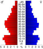
In the county the population was spread out with 28.30% under the age of 18, 6.80% from 18 to 24, 26.70% from 25 to 44, 23.40% from 45 to 64, and 14.90% who were 65 years of age or older. The median age was 37 years. For every 100 females there were 96.80 males. For every 100 females age 18 and over, there were 93.80 males.
The median income for a household
in the county was $40,451, and the median income for a family was $46,520. Males had a median income of $32,195 versus $22,305 for females. The per capita income
for the county was $18,606. About 6.40% of families and 8.80% of the population were below the poverty line, including 12.50% of those under age 18 and 9.20% of those age 65 or over.
. The city of Holton
is considered governmentally independent and is excluded from the census figures for the townships. In the following table, the population center is the largest city (or cities) included in that township's population total, if it is of a significant size.
Additional information
Maps
Kansas
Kansas is a US state located in the Midwestern United States. It is named after the Kansas River which flows through it, which in turn was named after the Kansa Native American tribe, which inhabited the area. The tribe's name is often said to mean "people of the wind" or "people of the south...
, in the Central
Central United States
The Central United States is sometimes conceived as between the Eastern United States and Western United States as part of a three-region model, roughly coincident with the Midwestern United States plus the western and central portions of the Southern United States; the term is also sometimes used...
United States
United States
The United States of America is a federal constitutional republic comprising fifty states and a federal district...
. As of the 2010 census, the county population was 13,462. Its county seat
County seat
A county seat is an administrative center, or seat of government, for a county or civil parish. The term is primarily used in the United States....
and most populous city is Holton
Holton, Kansas
Holton is a city in and the county seat of Jackson County, Kansas, United States. As of the 2010 census, the city population was 3,329. It is part of the Topeka, Kansas Metropolitan Statistical Area.-History:...
. The county along with Shawnee
Shawnee County, Kansas
Shawnee County is a county located in northeast Kansas, in the central United States of America. Its most populous city, Topeka, is the state capital and county seat. The county's population was 177,934 for the 2010 census...
, Jefferson
Jefferson County, Kansas
Jefferson County is a county located in Northeast Kansas, in the Central United States. As of the 2010 census, the county population was 19,126. Its county seat is Oskaloosa, and its most populous city is Valley Falls...
, Osage
Osage County, Kansas
Osage County is a county located in east-central Kansas, in the Central United States. As of the 2010 census, the county population was 16295. Its county seat is Lyndon, and its most populous city is Osage City. The county along with Shawnee, Jackson, Jefferson, and Wabaunsee counties is...
, and Wabaunsee
Wabaunsee County, Kansas
Wabaunsee County is a county located in the U.S. state of Kansas. As of the 2010 census, the county population was 7,053. Its county seat is Alma. It is part of the Topeka, Kansas Metropolitan Statistical Area...
counties is included in the Topeka
Topeka, Kansas
Topeka |Kansa]]: Tó Pee Kuh) is the capital city of the U.S. state of Kansas and the county seat of Shawnee County. It is situated along the Kansas River in the central part of Shawnee County, located in northeast Kansas, in the Central United States. As of the 2010 census, the city population was...
, Kansas
Kansas
Kansas is a US state located in the Midwestern United States. It is named after the Kansas River which flows through it, which in turn was named after the Kansa Native American tribe, which inhabited the area. The tribe's name is often said to mean "people of the wind" or "people of the south...
, Metropolitan Statistical Area
Topeka metropolitan area
The Topeka Metropolitan Statistical Area, as defined by the United States Census Bureau, is an area consisting of five counties in northeastern Kansas, anchored by the city of Topeka...
.
Law and government
Following amendment to the Kansas Constitution in 1986, the county remained a prohibition, or "dry"Dry county
A dry county is a county in the United States whose government forbids the sale of alcoholic beverages. Some prohibit off-premises sale, some prohibit on-premises sale, and some prohibit both. Hundreds of dry counties exist across the United States, almost all of them in the South...
, county until 2004, when voters approved the sale of alcoholic liquor by the individual drink with a 30% food sales requirement.
Geography
According to the 2000 census, the county has a total area of 657.86 square miles (1,703.8 km²), of which 655.59 square miles (1,698 km²) (or 99.65%) is land and 2.27 square miles (5.9 km²) (or 0.35%) is water.Adjacent counties
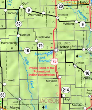
- Brown CountyBrown County, KansasBrown County is a county located in Northeast Kansas, in the Central United States. As of the 2010 census, the county population was 9,984. Its county seat and most populous city is Hiawatha...
(northeast) - Atchison CountyAtchison County, KansasAtchison County is a county located in Northeast Kansas, in the Central United States. As of the 2010 census, the county population was 16,924. Its county seat and most populous city is Atchison. The county is named in honor of David Rice Atchison, a United States Senator from Missouri...
(east) - Jefferson CountyJefferson County, KansasJefferson County is a county located in Northeast Kansas, in the Central United States. As of the 2010 census, the county population was 19,126. Its county seat is Oskaloosa, and its most populous city is Valley Falls...
(southeast) - Shawnee CountyShawnee County, KansasShawnee County is a county located in northeast Kansas, in the central United States of America. Its most populous city, Topeka, is the state capital and county seat. The county's population was 177,934 for the 2010 census...
(south) - Pottawatomie CountyPottawatomie County, KansasPottawatomie County is a county located in the U.S. state of Kansas. As of the 2010 census, the county population was 21,604. The county seat is Westmoreland. The county takes its name from the Potawatomi tribe of Native Americans...
(west) - Nemaha CountyNemaha County, KansasNemaha County is a county located in the northeastern part of the U.S. state of Kansas. As of the 2010 census, the county population was 10,178. The county seat is Seneca.- History :...
(northwest)
Demographics
United States Census, 2000
The Twenty-second United States Census, known as Census 2000 and conducted by the Census Bureau, determined the resident population of the United States on April 1, 2000, to be 281,421,906, an increase of 13.2% over the 248,709,873 persons enumerated during the 1990 Census...
, there were 12,657 people, 4,727 households, and 3,507 families residing in the county. The population density
Population density
Population density is a measurement of population per unit area or unit volume. It is frequently applied to living organisms, and particularly to humans...
was 19 people per square mile (7/km²). There were 5,094 housing units at an average density of 8 per square mile (3/km²). The racial makeup
Race (United States Census)
Race and ethnicity in the United States Census, as defined by the Federal Office of Management and Budget and the United States Census Bureau, are self-identification data items in which residents choose the race or races with which they most closely identify, and indicate whether or not they are...
of the county was 90.21% White
White American
White Americans are people of the United States who are considered or consider themselves White. The United States Census Bureau defines White people as those "having origins in any of the original peoples of Europe, the Middle East, or North Africa...
, 6.84% Native American
Native Americans in the United States
Native Americans in the United States are the indigenous peoples in North America within the boundaries of the present-day continental United States, parts of Alaska, and the island state of Hawaii. They are composed of numerous, distinct tribes, states, and ethnic groups, many of which survive as...
, 0.53% Black or African American
African American
African Americans are citizens or residents of the United States who have at least partial ancestry from any of the native populations of Sub-Saharan Africa and are the direct descendants of enslaved Africans within the boundaries of the present United States...
, 0.17% Asian
Asian American
Asian Americans are Americans of Asian descent. The U.S. Census Bureau definition of Asians as "Asian” refers to a person having origins in any of the original peoples of the Far East, Southeast Asia, or the Indian subcontinent, including, for example, Cambodia, China, India, Indonesia, Japan,...
, 0.02% Pacific Islander
Pacific Islander American
Pacific Islander Americans, also known as Oceanian Americans, are residents of the United States with original ancestry from Oceania. They represent the smallest racial group counted in the United States census of 2000. They numbered 874,000 people or 0.3 percent of the United States population...
, 0.39% from other races, and 1.84% from two or more races
Multiracial
The terms multiracial and mixed-race describe people whose ancestries come from multiple races. Unlike the term biracial, which often is only used to refer to having parents or grandparents of two different races, the term multiracial may encompass biracial people but can also include people with...
. Hispanic
Hispanic
Hispanic is a term that originally denoted a relationship to Hispania, which is to say the Iberian Peninsula: Andorra, Gibraltar, Portugal and Spain. During the Modern Era, Hispanic sometimes takes on a more limited meaning, particularly in the United States, where the term means a person of ...
or Latino
Latino
The demonyms Latino and Latina , are defined in English language dictionaries as:* "a person of Latin-American descent."* "A Latin American."* "A person of Hispanic, especially Latin-American, descent, often one living in the United States."...
of any race were 1.49% of the population.
There were 4,727 household
Household
The household is "the basic residential unit in which economic production, consumption, inheritance, child rearing, and shelter are organized and carried out"; [the household] "may or may not be synonymous with family"....
s out of which 35.20% had children under the age of 18 living with them, 62.30% were married couples
Marriage
Marriage is a social union or legal contract between people that creates kinship. It is an institution in which interpersonal relationships, usually intimate and sexual, are acknowledged in a variety of ways, depending on the culture or subculture in which it is found...
living together, 8.20% had a female householder with no husband present, and 25.80% were non-families. 22.70% of all households were made up of individuals and 11.50% had someone living alone who was 65 years of age or older. The average household size was 2.63 and the average family size was 3.09.
In the county the population was spread out with 28.30% under the age of 18, 6.80% from 18 to 24, 26.70% from 25 to 44, 23.40% from 45 to 64, and 14.90% who were 65 years of age or older. The median age was 37 years. For every 100 females there were 96.80 males. For every 100 females age 18 and over, there were 93.80 males.
The median income for a household
Median household income
The median household income is commonly used to generate data about geographic areas and divides households into two equal segments with the first half of households earning less than the median household income and the other half earning more...
in the county was $40,451, and the median income for a family was $46,520. Males had a median income of $32,195 versus $22,305 for females. The per capita income
Per capita income
Per capita income or income per person is a measure of mean income within an economic aggregate, such as a country or city. It is calculated by taking a measure of all sources of income in the aggregate and dividing it by the total population...
for the county was $18,606. About 6.40% of families and 8.80% of the population were below the poverty line, including 12.50% of those under age 18 and 9.20% of those age 65 or over.
Incorporated cities
Name and population (2004 estimate):- HoltonHolton, KansasHolton is a city in and the county seat of Jackson County, Kansas, United States. As of the 2010 census, the city population was 3,329. It is part of the Topeka, Kansas Metropolitan Statistical Area.-History:...
, 3,345 (county seat) - HoytHoyt, KansasHoyt is a city in Jackson County, Kansas, United States. The population was 571 at the 2000 census. It is part of the Topeka, Kansas Metropolitan Statistical Area.-Geography:Hoyt is located at...
, 587 - MayettaMayetta, KansasMayetta is a city in Jackson County, Kansas, United States. The population was 312 at the 2000 census. It is part of the Topeka, Kansas Metropolitan Statistical Area.-History:Mayetta was originally owned by a family by the name of Lungar...
, 342 - DenisonDenison, KansasDenison is a city in Jackson County, Kansas, United States. The population was 231 at the 2000 census. It is part of the Topeka, Kansas Metropolitan Statistical Area.-19th century:...
, 227 - WhitingWhiting, KansasWhiting is a city in Jackson County, Kansas, United States. The population was 206 at the 2000 census. It is part of the Topeka, Kansas Metropolitan Statistical Area.-Geography:Whiting is located at ....
, 211 - DeliaDelia, KansasDelia is a city in Jackson County, Kansas, United States. As of the 2000 census, the city had a population of 179. It is part of the Topeka, Kansas Metropolitan Statistical Area.-Geography:Delia is located at ....
, 184 - CirclevilleCircleville, KansasCircleville is a city in Jackson County, Kansas, United States. The population was 185 at the 2000 census. It is part of the Topeka, Kansas Metropolitan Statistical Area.-Geography:Circleville is located at ....
, 183 - NetawakaNetawaka, KansasNetawaka is a city in Jackson County, Kansas, United States. The population was 170 at the 2000 census. Netawaka takes its name from the Pottawatami Native American word meaning "grand view".-Geography:Netawaka is located at ....
, 169 - SoldierSoldier, KansasSoldier is a city in Jackson County, Kansas, United States. As of the 2010 census, the city population was 136. It is part of the Topeka, Kansas Metropolitan Statistical Area.-History:...
, 123
Townships
Jackson County is divided into fifteen townshipsCivil township
A civil township is a widely used unit of local government in the United States, subordinate to, and geographic divisions of, a county. Specific responsibilities and the degree of autonomy vary based on each state. Civil townships are distinct from survey townships, but in states that have both,...
. The city of Holton
Holton, Kansas
Holton is a city in and the county seat of Jackson County, Kansas, United States. As of the 2010 census, the city population was 3,329. It is part of the Topeka, Kansas Metropolitan Statistical Area.-History:...
is considered governmentally independent and is excluded from the census figures for the townships. In the following table, the population center is the largest city (or cities) included in that township's population total, if it is of a significant size.
| Township | FIPS | Population center |
Population | Population density /km² (/sq mi) |
Land area km² (sq mi) | Water area km² (sq mi) | Water % | Geographic coordinates |
|---|---|---|---|---|---|---|---|---|
| Adrian Adrian Township, Jackson County, Kansas Adrian Township is a township in Jackson County, Kansas, USA. As of the 2000 census, its population was 150.-Geography:Adrian Township covers an area of 29.83 square miles ; of this, 0.08 square miles or 0.26 percent is water... |
00350 | 150 | 2 (5) | 77 (30) | 0 (0) | 0.25% | 39°21′17"N 95°59′43"W | |
| Banner Banner Township, Jackson County, Kansas Banner Township is a township in Jackson County, Kansas, USA. As of the 2000 census, its population was 300.-Geography:Banner Township covers an area of 36.02 square miles ; of this, 0.25 square miles or 0.7 percent is water.-Adjacent townships:* Jefferson Township * Liberty Township * Franklin... |
04025 | 300 | 3 (8) | 93 (36) | 1 (0) | 0.70% | 39°26′5"N 95°50′25"W | |
| Cedar Cedar Township, Jackson County, Kansas Cedar Township is a township in Jackson County, Kansas, USA. As of the 2000 census, its population was 1,254.-Geography:Cedar Township covers an area of 39.94 square miles ; of this, 0.01 square miles or 0.04 percent is water... |
11275 | 1,254 | 12 (31) | 103 (40) | 0 (0) | 0.03% | 39°20′53"N 95°40′44"W | |
| Douglas Douglas Township, Jackson County, Kansas Douglas Township is a township in Jackson County, Kansas, USA. As of the 2000 census, its population was 2,135.-Geography:Douglas Township covers an area of 64.81 square miles ; of this, 0.04 square miles or 0.07 percent is water... |
18350 | 2,135 | 13 (33) | 168 (65) | 0 (0) | 0.07% | 39°15′34"N 95°41′2"W | |
| Franklin Franklin Township, Jackson County, Kansas Franklin Township is a township in Jackson County, Kansas, USA. As of the 2000 census, its population was 776.-Geography:Franklin Township covers an area of 33.43 square miles ; of this, 1.1 square miles or 3.28 percent is water... |
24400 | 776 | 9 (24) | 84 (32) | 3 (1) | 3.28% | 39°26′41"N 95°44′35"W | |
| Garfield Garfield Township, Jackson County, Kansas Garfield Township is a township in Jackson County, Kansas, USA. As of the 2000 census, its population was 624.-Geography:Garfield Township covers an area of 34 square miles ; of this, 0.17 square miles or 0.49 percent is water... |
25625 | 624 | 7 (18) | 88 (34) | 0 (0) | 0.49% | 39°25′35"N 95°38′9"W | |
| Grant Grant Township, Jackson County, Kansas Grant Township is a township in Jackson County, Kansas, USA. As of the 2000 census, its population was 212.-Geography:Grant Township covers an area of 42 square miles ; of this, 0.04 square miles or 0.1 percent is water.-Adjacent townships:* Soldier Township * Jefferson Township * Banner Township... |
27700 | 212 | 2 (5) | 109 (42) | 0 (0) | 0.10% | 39°26′47"N 95°58′14"W | |
| Jefferson Jefferson Township, Jackson County, Kansas Jefferson Township is a township in Jackson County, Kansas, USA. As of the 2000 census, its population was 494.-Geography:Jefferson Township covers an area of 36.39 square miles ; of this, 0.04 square miles or 0.12 percent is water.-Adjacent townships:* Wetmore Township, Nemaha County * Liberty... |
35225 | 494 | 5 (14) | 94 (36) | 0 (0) | 0.12% | 39°31′0"N 95°50′38"W | |
| Liberty Liberty Township, Jackson County, Kansas Liberty Township is a township in Jackson County, Kansas, USA. As of the 2000 census, its population was 513.-Geography:Liberty Township covers an area of 35.43 square miles ; of this, 0.06 square miles or 0.15 percent is water... |
40125 | 513 | 6 (15) | 92 (35) | 0 (0) | 0.16% | 39°31′3"N 95°44′36"W | |
| Lincoln Lincoln Township, Jackson County, Kansas Lincoln Township is a township in Jackson County, Kansas, USA. As of the 2000 census, its population was 1,046.-Geography:Lincoln Township covers an area of 98.35 square miles ; of this, 0.04 square miles or 0.05 percent is water... |
40750 | 1,046 | 4 (11) | 255 (98) | 0 (0) | 0.05% | 39°19′40"N 95°50′26"W | |
| Netawaka Netawaka Township, Jackson County, Kansas Netawaka Township is a township in Jackson County, Kansas, USA. As of the 2000 census, its population was 361.-Geography:Netawaka Township covers an area of 36.09 square miles ; of this, 0.05 square miles or 0.13 percent is water... |
49975 | 361 | 4 (10) | 93 (36) | 0 (0) | 0.13% | 39°36′42"N 95°43′47"W | |
| Soldier Soldier Township, Jackson County, Kansas Soldier Township is a township in Jackson County, Kansas, USA. As of the 2000 census, its population was 403.-Geography:Soldier Township covers an area of 42.63 square miles ; of this, 0.07 square miles or 0.17 percent is water.-Adjacent townships:* Reilly Township, Nemaha County * Jefferson... |
66200 | 403 | 4 (9) | 110 (43) | 0 (0) | 0.17% | 39°31′22"N 95°58′27"W | |
| Straight Creek Straight Creek Township, Jackson County, Kansas Straight Creek Township is a township in Jackson County, Kansas, USA. As of the 2000 census, its population was 158.-Geography:Straight Creek Township covers an area of 36.72 square miles ; of this, 0.11 square miles or 0.29 percent is water.-Adjacent townships:* Whiting Township * Grasshopper... |
68475 | 158 | 2 (4) | 95 (37) | 0 (0) | 0.30% | 39°31′24"N 95°37′0"W | |
| Washington Washington Township, Jackson County, Kansas Washington Township is a township in Jackson County, Kansas, USA. As of the 2000 census, its population was 516.-Geography:Washington Township covers an area of 53.69 square miles ; of this, 0.07 square miles or 0.14 percent is water... |
75625 | 516 | 4 (10) | 139 (54) | 0 (0) | 0.13% | 39°15′5"N 95°58′1"W | |
| Whiting Whiting Township, Jackson County, Kansas Whiting Township is a township in Jackson County, Kansas, USA. As of the 2000 census, its population was 362.-Geography:Whiting Township covers an area of 36 square miles ; of this, 0.04 square miles or 0.12 percent is water... |
78125 | 362 | 4 (10) | 93 (36) | 0 (0) | 0.11% | 39°36′4"N 95°36′57"W | |
| Sources: | ||||||||
Education
Unified school districts
- Jackson Heights USD 335Jackson Heights USD 335Jackson Heights is a K-12 school located five miles north of Holton, KS. The high school is notable for having previously been an Atlas nuclear missile site.- Grade 11 State Testing Data :...
- Holton USD 336
- Royal Valley USD 337
See also
- National Register of Historic Places listings in Jackson County, Kansas
Further reading
- History of the State of Kansas; William G. Cutler; A.T. Andreas Publisher; 1883. (Online HTML eBook)
- Kansas : A Cyclopedia of State History, Embracing Events, Institutions, Industries, Counties, Cities, Towns, Prominent Persons, Etc; 3 Volumes; Frank W. Blackmar; Standard Publishing Co; 944 / 955 / 824 pages; 1912. (Volume1 - Download 54MB PDF eBook),(Volume2 - Download 53MB PDF eBook), (Volume3 - Download 33MB PDF eBook)
External links
Official sitesAdditional information
Maps
- 2003 Jackson County Map, KDOT
- 2011 Kansas Highway Map, KDOT
- 2011 Kansas Railroad Map, KDOT
- 2005 Kansas School District Boundary Map, KSDE