

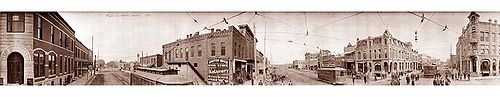
Winfield, Kansas
Encyclopedia
Winfield is a city
situated along the Walnut River
in the west-central part of Cowley County
, located in South Central Kansas
, in the Central
United States
. As of the 2010 census, the city population was 12,301. It is the county seat
and most populous city of Cowley County.
to El Dorado
, in 1881 it was extended to Douglass
, and later to Arkansas City
. The line was leased and operated by the Atchison, Topeka and Santa Fe Railway
. The line from Florence
to El Dorado
was abandoned in 1942. The original branch line connected Florence
, Burns
, De Graff, El Dorado
, Augusta
, Douglass
, Rock
, Akron, Winfield, Arkansas City
.
, a four-year private Methodist
college and once also held St. John's College
before it closed in 1986.
The city is well known for hosting the Walnut Valley Festival
, a large bluegrass and acoustic music festival, on the third weekend of every September.
The fictional castaway Mary Ann Summers
from Gilligan's Island
hailed from Winfield.
(Phase II) was constructed west of Winfield, north to south through Cowley County
, with much controversy over tax exemption and environmental concerns (if a leak ever occurs).
at its confluence with Timber Creek. It is located 17 miles (27.4 km) north of the Kansas
-Oklahoma
state border at the junction of U.S. Routes 77
and 160
. State highway route K-15
follows U.S. Route 77 to the north of the city and U.S. Route 160 to the east. K-360
is a bypass
around the southeastern part of the city between U.S. Route 77 and U.S. Route 160. Arkansas City
is 13 miles (20.9 km) south of Winfield along U.S. Route 77, and Strother Field
, a general aviation
airport, is about five miles (8 km) south.
According to the United States Census Bureau
, the city has a total area of 12.8 square miles (33.2 km²), of which 11.1 square miles (28.7 km²) is land and 1.7 square miles (4.4 km²), or 13.25%, is water.
The area receives nearly 38 inches (965.2 mm) of precipitation during an average year with the largest share being received in May and June—with a combined 20 days of measurable precipitation. During a typical year the total amount of precipitation may be anywhere from 26 to 50 inches (1,270 mm). There are on average 90 days of measurable precipitation per year. Winter snowfall averages almost 12 inches, but the median is less than 3 inches (76.2 mm). Measurable snowfall occurs an average of 7 days per year with at least an inch of snow being received on four of those days. Snow depth of at least an inch occurs an average of 11 days per year.
 Winfield's population was estimated to be 11,861 in the year 2005, a decrease of 357, or -2.9%, over the previous five years.
As of the census
of 2000, there were 12,206 people, 4,627 households, and 2,952 families residing in the city. The population density
was 1,104.0 people per square mile (426.1/km²). There were 5,049 housing units at an average density of 456.7 per square mile (176.3/km²). The racial makeup of the city was 88.06% White
, 3.26% Black
or African American
, 1.08% Native American
, 3.74% Asian
, 0.02% Pacific Islander
, 1.73% from other races
, and 2.12% from two or more races. Hispanic
or Latino
of any race were 4.66% of the population.
There were 4,627 households out of which 31.9% had children under the age of 18 living with them, 49.6% were married couples
living together, 10.7% had a female householder with no husband present, and 36.2% were non-families. 32.4% of all households were made up of individuals and 16.9% had someone living alone who was 65 years of age or older. The average household size was 2.36 and the average family size was 3.00.
In the city the population was spread out with 24.9% under the age of 18, 11.8% from 18 to 24, 27.4% from 25 to 44, 19.4% from 45 to 64, and 16.6% who were 65 years of age or older. The median age was 36 years. For every 100 females there were 98.5 males. For every 100 females age 18 and over, there were 97.0 males.
The median income for a household
in the city was $34,443, and the median income for a family was $44,539. Males had a median income of $31,768 versus $21,605 for females. The per capita income
for the city was $19,162. About 9.9% of families and 13.8% of the population were below the poverty line, including 18.6% of those under age 18 and 11.4% of those age 65 or over.
Kansas
Schools
Events
Maps
City
A city is a relatively large and permanent settlement. Although there is no agreement on how a city is distinguished from a town within general English language meanings, many cities have a particular administrative, legal, or historical status based on local law.For example, in the U.S...
situated along the Walnut River
Walnut River
The Walnut River is a tributary of the Arkansas River, long, in the Flint Hills region of Kansas in the United States. Via the Arkansas, it is part of the Mississippi River watershed....
in the west-central part of Cowley County
Cowley County, Kansas
Cowley County is a county located in south-central Kansas, in the Central United States. As of the 2010 census, the county population was 36,311. Its county seat and most populous city is Winfield...
, located in South Central Kansas
Kansas
Kansas is a US state located in the Midwestern United States. It is named after the Kansas River which flows through it, which in turn was named after the Kansa Native American tribe, which inhabited the area. The tribe's name is often said to mean "people of the wind" or "people of the south...
, in the Central
Central United States
The Central United States is sometimes conceived as between the Eastern United States and Western United States as part of a three-region model, roughly coincident with the Midwestern United States plus the western and central portions of the Southern United States; the term is also sometimes used...
United States
United States
The United States of America is a federal constitutional republic comprising fifty states and a federal district...
. As of the 2010 census, the city population was 12,301. It is the county seat
County seat
A county seat is an administrative center, or seat of government, for a county or civil parish. The term is primarily used in the United States....
and most populous city of Cowley County.
19th century
In 1877, the Florence, El Dorado, and Walnut Valley Railroad Company built a branch line from FlorenceFlorence, Kansas
Florence is a city in Marion County, Kansas, United States. The city was named after the daughter of former Kansas Governor Samuel J. Crawford. As of the 2010 census, the city population was 465.-19th century:...
to El Dorado
El Dorado, Kansas
El Dorado is a city situated along the Walnut River in the central part of Butler County, located in south-central Kansas, in the Central United States. As of the 2010 census, the city population was 13,021. It is the county seat and most populous city of Butler County...
, in 1881 it was extended to Douglass
Douglass, Kansas
Douglass is a city in Butler County, Kansas, United States. As of the 2010 census, the city population was 1,700.-19th century:In 1877, the Florence, El Dorado, and Walnut Valley Railroad Company built a branch line from Florence to El Dorado, in 1881 it was extended to Douglass, and later to...
, and later to Arkansas City
Arkansas City, Kansas
Arkansas City is a city situated at the confluence of the Arkansas and Walnut rivers in the southwestern part of Cowley County, located in south-central Kansas, in the central United States. As of the 2010 census, the city population was 12,415....
. The line was leased and operated by the Atchison, Topeka and Santa Fe Railway
Atchison, Topeka and Santa Fe Railway
The Atchison, Topeka and Santa Fe Railway , often abbreviated as Santa Fe, was one of the larger railroads in the United States. The company was first chartered in February 1859...
. The line from Florence
Florence, Kansas
Florence is a city in Marion County, Kansas, United States. The city was named after the daughter of former Kansas Governor Samuel J. Crawford. As of the 2010 census, the city population was 465.-19th century:...
to El Dorado
El Dorado, Kansas
El Dorado is a city situated along the Walnut River in the central part of Butler County, located in south-central Kansas, in the Central United States. As of the 2010 census, the city population was 13,021. It is the county seat and most populous city of Butler County...
was abandoned in 1942. The original branch line connected Florence
Florence, Kansas
Florence is a city in Marion County, Kansas, United States. The city was named after the daughter of former Kansas Governor Samuel J. Crawford. As of the 2010 census, the city population was 465.-19th century:...
, Burns
Burns, Kansas
Burns is a city in Marion County, Kansas, United States. The city name came from a nearby train station, which was named prior to the city being incorporated. As of the 2010 census, the city population was 228.-History:-19th century:...
, De Graff, El Dorado
El Dorado, Kansas
El Dorado is a city situated along the Walnut River in the central part of Butler County, located in south-central Kansas, in the Central United States. As of the 2010 census, the city population was 13,021. It is the county seat and most populous city of Butler County...
, Augusta
Augusta, Kansas
Augusta is a city in Butler County, Kansas, United States. As of the 2010 census, the city population was 9,274.-19th century:The confluence of the Whitewater River and the Walnut River was originally inhabited by Native Americans , who found the land ideal for hunting and fishing. In 1868 C. N...
, Douglass
Douglass, Kansas
Douglass is a city in Butler County, Kansas, United States. As of the 2010 census, the city population was 1,700.-19th century:In 1877, the Florence, El Dorado, and Walnut Valley Railroad Company built a branch line from Florence to El Dorado, in 1881 it was extended to Douglass, and later to...
, Rock
Rock, Kansas
Rock is an unincorporated community in Cowley County, Kansas, United States.-19th century:The post office was established August 12, 1870. The nearby Bucher Bridge is on the National Register of Historic Places....
, Akron, Winfield, Arkansas City
Arkansas City, Kansas
Arkansas City is a city situated at the confluence of the Arkansas and Walnut rivers in the southwestern part of Cowley County, located in south-central Kansas, in the central United States. As of the 2010 census, the city population was 12,415....
.
20th century
Winfield is home to Southwestern CollegeSouthwestern College (Kansas)
Southwestern College is a four-year private college affiliated with the United Methodist Church located in Winfield, Kansas, United States. It was founded in 1885 and graduated its first class in 1889. In addition to its campus programs, it offers online programs.-Academics:The main campus is a...
, a four-year private Methodist
United Methodist Church
The United Methodist Church is a Methodist Christian denomination which is both mainline Protestant and evangelical. Founded in 1968 by the union of The Methodist Church and the Evangelical United Brethren Church, the UMC traces its roots back to the revival movement of John and Charles Wesley...
college and once also held St. John's College
St. John's College (Kansas)
St. John's College was a two-year college located in Winfield, Kansas and was operated by the Lutheran Church-Missouri Synod. The school began operation in 1893 and ceased operation in 1986, after over 9,000 students had been through its programs....
before it closed in 1986.
The city is well known for hosting the Walnut Valley Festival
Walnut Valley Festival
The Walnut Valley Festival is a well-known acoustic music festival, held annually in Winfield, Kansas. The main genre of music is bluegrass, but other acoustic styles are represented...
, a large bluegrass and acoustic music festival, on the third weekend of every September.
The fictional castaway Mary Ann Summers
Mary Ann Summers
Mary Ann Summers is a fictional character in the television sitcom Gilligan's Island which ran on the CBS network from 1964 to 1967, and has run more or less continuously since in reruns.- Role :...
from Gilligan's Island
Gilligan's Island
Gilligan's Island is an American television series created and produced by Sherwood Schwartz and originally produced by United Artists Television. The situation comedy series featured Bob Denver; Alan Hale, Jr.; Jim Backus; Natalie Schafer; Tina Louise; Russell Johnson; and Dawn Wells. It aired for...
hailed from Winfield.
21st century
In 2010, the Keystone-Cushing PipelineKeystone Pipeline
The Keystone Pipeline System is a pipeline system to transport synthetic crude oil and diluted bitumen from the Athabasca Oil Sands in northeastern Alberta, Canada to multiple destinations in the United States, which include refineries in Illinois, Cushing oil distribution hub in Oklahoma, and...
(Phase II) was constructed west of Winfield, north to south through Cowley County
Cowley County, Kansas
Cowley County is a county located in south-central Kansas, in the Central United States. As of the 2010 census, the county population was 36,311. Its county seat and most populous city is Winfield...
, with much controversy over tax exemption and environmental concerns (if a leak ever occurs).
Geography
Winfield is located at 37°14′52"N 96°58′50"W. The city is situated along the Walnut RiverWalnut River
The Walnut River is a tributary of the Arkansas River, long, in the Flint Hills region of Kansas in the United States. Via the Arkansas, it is part of the Mississippi River watershed....
at its confluence with Timber Creek. It is located 17 miles (27.4 km) north of the Kansas
Kansas
Kansas is a US state located in the Midwestern United States. It is named after the Kansas River which flows through it, which in turn was named after the Kansa Native American tribe, which inhabited the area. The tribe's name is often said to mean "people of the wind" or "people of the south...
-Oklahoma
Oklahoma
Oklahoma is a state located in the South Central region of the United States of America. With an estimated 3,751,351 residents as of the 2010 census and a land area of 68,667 square miles , Oklahoma is the 28th most populous and 20th-largest state...
state border at the junction of U.S. Routes 77
U.S. Route 77
U.S. Route 77 is a north–south United States highway. It is unsigned in and around Dallas, Texas. Its historic segment through South Dakota and Minnesota was decommissioned with the advent of Interstate 29 but otherwise the route has been spared the decommissioning that has shortened other US...
and 160
U.S. Route 160
U.S. Route 160 is a 1,465 mile long east–west United States highway in the Midwestern United States. The western terminus of the route is at U.S. Route 89 five miles west of Tuba City, Arizona. The eastern terminus is at U.S...
. State highway route K-15
K-15 (Kansas highway)
K-15 is a Kansas state highway originating at the Oklahoma state line and continuing to the Nebraska state line where it is then signed as Nebraska Highway 15. It is signed as State Highway 18 once the highway enters Oklahoma. It is 206 miles long...
follows U.S. Route 77 to the north of the city and U.S. Route 160 to the east. K-360
K-360 (Kansas highway)
K-360 is a state highway in the U.S. state of Kansas. K-360 is a four-mile south and east partial bypass of Winfield that serves area industries...
is a bypass
Bypass (road)
A bypass is a road or highway that avoids or "bypasses" a built-up area, town, or village, to let through traffic flow without interference from local traffic, to reduce congestion in the built-up area, and to improve road safety....
around the southeastern part of the city between U.S. Route 77 and U.S. Route 160. Arkansas City
Arkansas City, Kansas
Arkansas City is a city situated at the confluence of the Arkansas and Walnut rivers in the southwestern part of Cowley County, located in south-central Kansas, in the central United States. As of the 2010 census, the city population was 12,415....
is 13 miles (20.9 km) south of Winfield along U.S. Route 77, and Strother Field
Strother Field
Strother Field is a public airport located in Cowley County, Kansas, five miles southwest of the central business district of Winfield and north of Arkansas City...
, a general aviation
General aviation
General aviation is one of the two categories of civil aviation. It refers to all flights other than military and scheduled airline and regular cargo flights, both private and commercial. General aviation flights range from gliders and powered parachutes to large, non-scheduled cargo jet flights...
airport, is about five miles (8 km) south.
According to the United States Census Bureau
United States Census Bureau
The United States Census Bureau is the government agency that is responsible for the United States Census. It also gathers other national demographic and economic data...
, the city has a total area of 12.8 square miles (33.2 km²), of which 11.1 square miles (28.7 km²) is land and 1.7 square miles (4.4 km²), or 13.25%, is water.
Climate
Over the course of a year, temperatures range from an average low below 20 °F (-6.7 °C) in January to an average high of nearly 93 °F (33.9 °C) in July. The maximum temperature reaches 90 °F (32.2 °C) an average of 69 days per year and reaches 100 °F (37.8 °C) an average of 12 days per year. The minimum temperature falls below the freezing point (32°F) an average of 102 days per year. Typically the first fall freeze occurs between early October and the first week of November, and the last spring freeze occurs during the month of April.The area receives nearly 38 inches (965.2 mm) of precipitation during an average year with the largest share being received in May and June—with a combined 20 days of measurable precipitation. During a typical year the total amount of precipitation may be anywhere from 26 to 50 inches (1,270 mm). There are on average 90 days of measurable precipitation per year. Winter snowfall averages almost 12 inches, but the median is less than 3 inches (76.2 mm). Measurable snowfall occurs an average of 7 days per year with at least an inch of snow being received on four of those days. Snow depth of at least an inch occurs an average of 11 days per year.
| Month | Jan | Feb | Mar | Apr | May | Jun | Jul | Aug | Sep | Oct | Nov | Dec | Year |
|---|---|---|---|---|---|---|---|---|---|---|---|---|---|
| Notes: Temperature Temperature Temperature is a physical property of matter that quantitatively expresses the common notions of hot and cold. Objects of low temperature are cold, while various degrees of higher temperatures are referred to as warm or hot... s are in degrees Fahrenheit Fahrenheit Fahrenheit is the temperature scale proposed in 1724 by, and named after, the German physicist Daniel Gabriel Fahrenheit . Within this scale, the freezing of water into ice is defined at 32 degrees, while the boiling point of water is defined to be 212 degrees... . Precipitation Precipitation (meteorology) In meteorology, precipitation In meteorology, precipitation In meteorology, precipitation (also known as one of the classes of hydrometeors, which are atmospheric water phenomena is any product of the condensation of atmospheric water vapor that falls under gravity. The main forms of precipitation... includes rain Rain Rain is liquid precipitation, as opposed to non-liquid kinds of precipitation such as snow, hail and sleet. Rain requires the presence of a thick layer of the atmosphere to have temperatures above the melting point of water near and above the Earth's surface... and melted snow Snow Snow is a form of precipitation within the Earth's atmosphere in the form of crystalline water ice, consisting of a multitude of snowflakes that fall from clouds. Since snow is composed of small ice particles, it is a granular material. It has an open and therefore soft structure, unless packed by... or sleet Ice pellets Ice pellets are a form of precipitation consisting of small, translucent balls of ice. Ice pellets usually are smaller than hailstones. They often bounce when they hit the ground, and generally do not freeze into a solid mass unless mixed with freezing rain... in inch Inch An inch is the name of a unit of length in a number of different systems, including Imperial units, and United States customary units. There are 36 inches in a yard and 12 inches in a foot... es; median Median In probability theory and statistics, a median is described as the numerical value separating the higher half of a sample, a population, or a probability distribution, from the lower half. The median of a finite list of numbers can be found by arranging all the observations from lowest value to... values are provided for precipitation and snowfall because mean Arithmetic mean In mathematics and statistics, the arithmetic mean, often referred to as simply the mean or average when the context is clear, is a method to derive the central tendency of a sample space... averages may be misleading. Mean and median values are for the 30-year period 1971–2000; temperature extremes are for the station's period of record (1900–2001). The station is located in Winfield at 37°14′N 96°58′W, elevation 1160 feet (353.6 m). |
|||||||||||||
Demographics
As of the census
Census
A census is the procedure of systematically acquiring and recording information about the members of a given population. It is a regularly occurring and official count of a particular population. The term is used mostly in connection with national population and housing censuses; other common...
of 2000, there were 12,206 people, 4,627 households, and 2,952 families residing in the city. The population density
Population density
Population density is a measurement of population per unit area or unit volume. It is frequently applied to living organisms, and particularly to humans...
was 1,104.0 people per square mile (426.1/km²). There were 5,049 housing units at an average density of 456.7 per square mile (176.3/km²). The racial makeup of the city was 88.06% White
Race (United States Census)
Race and ethnicity in the United States Census, as defined by the Federal Office of Management and Budget and the United States Census Bureau, are self-identification data items in which residents choose the race or races with which they most closely identify, and indicate whether or not they are...
, 3.26% Black
Race (United States Census)
Race and ethnicity in the United States Census, as defined by the Federal Office of Management and Budget and the United States Census Bureau, are self-identification data items in which residents choose the race or races with which they most closely identify, and indicate whether or not they are...
or African American
Race (United States Census)
Race and ethnicity in the United States Census, as defined by the Federal Office of Management and Budget and the United States Census Bureau, are self-identification data items in which residents choose the race or races with which they most closely identify, and indicate whether or not they are...
, 1.08% Native American
Race (United States Census)
Race and ethnicity in the United States Census, as defined by the Federal Office of Management and Budget and the United States Census Bureau, are self-identification data items in which residents choose the race or races with which they most closely identify, and indicate whether or not they are...
, 3.74% Asian
Race (United States Census)
Race and ethnicity in the United States Census, as defined by the Federal Office of Management and Budget and the United States Census Bureau, are self-identification data items in which residents choose the race or races with which they most closely identify, and indicate whether or not they are...
, 0.02% Pacific Islander
Race (United States Census)
Race and ethnicity in the United States Census, as defined by the Federal Office of Management and Budget and the United States Census Bureau, are self-identification data items in which residents choose the race or races with which they most closely identify, and indicate whether or not they are...
, 1.73% from other races
Race (United States Census)
Race and ethnicity in the United States Census, as defined by the Federal Office of Management and Budget and the United States Census Bureau, are self-identification data items in which residents choose the race or races with which they most closely identify, and indicate whether or not they are...
, and 2.12% from two or more races. Hispanic
Race (United States Census)
Race and ethnicity in the United States Census, as defined by the Federal Office of Management and Budget and the United States Census Bureau, are self-identification data items in which residents choose the race or races with which they most closely identify, and indicate whether or not they are...
or Latino
Race (United States Census)
Race and ethnicity in the United States Census, as defined by the Federal Office of Management and Budget and the United States Census Bureau, are self-identification data items in which residents choose the race or races with which they most closely identify, and indicate whether or not they are...
of any race were 4.66% of the population.
There were 4,627 households out of which 31.9% had children under the age of 18 living with them, 49.6% were married couples
Marriage
Marriage is a social union or legal contract between people that creates kinship. It is an institution in which interpersonal relationships, usually intimate and sexual, are acknowledged in a variety of ways, depending on the culture or subculture in which it is found...
living together, 10.7% had a female householder with no husband present, and 36.2% were non-families. 32.4% of all households were made up of individuals and 16.9% had someone living alone who was 65 years of age or older. The average household size was 2.36 and the average family size was 3.00.
In the city the population was spread out with 24.9% under the age of 18, 11.8% from 18 to 24, 27.4% from 25 to 44, 19.4% from 45 to 64, and 16.6% who were 65 years of age or older. The median age was 36 years. For every 100 females there were 98.5 males. For every 100 females age 18 and over, there were 97.0 males.
The median income for a household
Median household income
The median household income is commonly used to generate data about geographic areas and divides households into two equal segments with the first half of households earning less than the median household income and the other half earning more...
in the city was $34,443, and the median income for a family was $44,539. Males had a median income of $31,768 versus $21,605 for females. The per capita income
Per capita income
Per capita income or income per person is a measure of mean income within an economic aggregate, such as a country or city. It is calculated by taking a measure of all sources of income in the aggregate and dividing it by the total population...
for the city was $19,162. About 9.9% of families and 13.8% of the population were below the poverty line, including 18.6% of those under age 18 and 11.4% of those age 65 or over.
Further reading
County- History of Cowley County Kansas; D.A. Millington / E.P. Greer; Winfield Courier; 162 pages; 1901. (Download 16MB PDF eBook)
Kansas
- History of the State of Kansas; William G. Cutler; A.T. Andreas Publisher; 1883. (Online HTML eBook)
- Kansas : A Cyclopedia of State History, Embracing Events, Institutions, Industries, Counties, Cities, Towns, Prominent Persons, Etc; 3 Volumes; Frank W. Blackmar; Standard Publishing Co; 944 / 955 / 824 pages; 1912. (Volume1 - Download 54MB PDF eBook), (Volume2 - Download 53MB PDF eBook), (Volume3 - Download 33MB PDF eBook)
External links
CitySchools
- USD 465, local school district
- Southwestern College
Events
Maps
- Winfield City Map, KDOT
- Cowley County Map, KDOT