
June 2008 Midwest floods
Encyclopedia
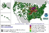
The June 2008 Midwestern United States floods were flooding events which affected portions of the Midwest United States. After months of heavy precipitation, a number of rivers overflowed their banks for several weeks at a time and broke through levee
s at numerous locations. Flooding continued into July. States
affected by the flooding included Illinois
, Indiana
, Iowa
, Michigan
, Minnesota
, Missouri
, and Wisconsin
. The American Red Cross
assisted the victims of flooding and tornadoes across seven states and the National Guard was mobilized to assist in disaster relief and evacuation.
Flooding continued as long as two weeks with central Iowa
and Cedar Rapids being hardest hit. The upper Mississippi Valley experienced flooding in Missouri
and Illinois
as the region's estuaries drained the floodwater into the river. The flood left thirteen dead and damage region-wide was estimated to be in the tens of billions of dollars.
deemed Clark, Coles
, Crawford, Cumberland, Jasper
and Lawrence counties as disaster areas. Levee breaks on June 10 flooded portions of Lawrence County near Lawrenceville
, inundating a campsite and forcing the evacuations of 200 homes.
On June 14 many communities located along the Mississippi River in West Central Illinois were notified by the National Weather Service that crests along the river would exceed the record crests of 1993.
On the early morning of June 14, the town of Oquawka, Illinois
was evacuated, due to a levee breach
along the swollen Iowa River
. The city council believed this would affect the flood waters in the already flooding Mississippi River
. The same day two levees broke near the town of Keithsburg, Illinois
, flooding the entire town.
On the morning of June 15, a levee along the Mississippi River
in the town of Gulfport
failed, flooding most of the town. Two more levees were breached by flood waters in western Illinois on June 18. The breaches flooded farmland near Meyer
and forced an evacuation of the town.
More than $7.2 million in federal disaster assistance grants and loans were approved by the Federal Emergency Management Agency
and the U.S. Small Business Administration for Illinois residents who suffered damages and losses.
. Additional rain on June 7 brought the worst of the flooding to larger portions of south-central and western Indiana. The highest recorded rainfall was in the town of Edinburgh
, which saw 10.94 inches (277.9 mm) of rain in seven hours. Paragon
had 10 inches (254 mm) of rain in just a few hours, leaving 90% of the town underwater.
Some parts of the state had flood levels exceeding records set in 1913. On June 9, President
George W. Bush
declared 29 counties in central Indiana a major disaster area, enabling the region to receive federal aid and Federal Emergency Management Agency
assistance.
Mitch Daniels
declared a state of emergency
in 23 counties and called in the United States Coast Guard
to assist in evacuations and rescues. The Coast Guard responded by sending two helicopters to the state along with boats and personnel. The Indiana National Guard
was called out to assist in evacuation and direct traffic and enforce road blocks on the many flooded roads. Some areas of southern Indianapolis
, where the White River
was several feet past flood stage, were evacuated. This included a hospital with one hundred patients and doctors. The Coast Guard continued to rescue trapped citizens on June 8. In Franklin, Indiana
water rose as high as the first floor of Johnson Memorial Hospital. Doctors and patients were also evacuated from Columbus Regional Hospital in Columbus, Indiana
. The hospital had to remain closed for an extended period of time because of power outages, generator failures, and extensive flood damage. It was expected to resume operations between September and December 2008, although emergency services began more quickly. All patients were evacuated and moved to nearby hospitals. One hundred and fifty people were evacuated from a nursing home in Morgan County
.
 The dam at Prince's Lake failed on June 7, threatening the community of Nineveh, Indiana
. On June 8 the Wabash Valley
between Lafayette and Terre Haute, Indiana
was placed under flood alert; all residents near the Wabash River
were urged to evacuate their homes.
Looting
was reported in Seymour, Indiana
where the White River
had overflowed its banks and forced the evacuation of over one hundred homes. Governor Daniels dispatched extra state police to the city to curb the looting. On June 10, five hundred members of the Kentucky National Guard
were mobilized to assist Indiana in coping with the flood damage and rescuing stranded citizens. The same day floodwaters rose above record levels in at least five localities. In others the rising waters were near or at the historic 1913 flood levels. The flooding was the worst in Indiana's modern history, according to Scott Morlock, a hydrologist with the U.S. Geological Survey in Indiana.
Many roads were closed because of high water, including Interstate 65
, which was closed southbound at the interchange with Interstate 465
through Seymour. On June 16 Ball State University
released a report estimating that preliminary damages in the state would cost at least $126 million, with $45.8 million in damage to public infrastructure and the rest damage to private businesses and homes. Although damage estimates are likely to be revised upward, the current estimate ranks the flood as the second costliest in Indiana history. Governor Mitch Daniels said the state is compiling its own thorough estimates, with total damages expected to top $1 billion. This would include agricultural costs (of over $800 million) and clean-up efforts not included in the Ball State University Study. The agricultural damages from this flood event varied dramatically since the timing of the flood permitted extensive replanting. The joint Ball State University and University of Tennessee study by Mark Burton and Michael J. Hicks
excluded not only agricultural damage in Indiana, but also did not include any alrge public structures (e.g. hospitals) located in flood plains.
.
Two deaths were reported in Columbus, Indiana
. The first was confirmed by the Department of Homeland Security on June 8. On June 9, the body of a Cummins
employee was discovered a mile from where he was sighted swept away by floodwaters.
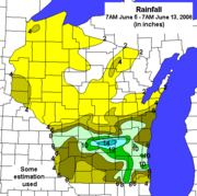
led to evacuations of many homes. In eastern Iowa along the Iowa River
and Cedar River, flooding was expected to exceed that of the Flood of 1993. Flooding also forced the closure of a number of roads throughout the state, reaching the point where travel was not advised in some parts of the state.
On Monday, June 9 the Upper Iowa River
in Decorah
flooded when a levee
was breached. Up to 6 inches (152 mm) of rain had fallen in the 48 hours prior. The water flooded parts of the lower campus of Luther College
, damaging athletic fields and the Regents Center. Winneshiek County
officials called this the worst flood to occur in Decorah since the current levee system was put in place in the 1940s. Other portions of the city were flooded. For a time, worries of losing the sanitary sewer system led to a 'please don't flush' order; as of Friday, 13 June 2008, this order was withdrawn, but pleas for careful use remain in effect. Decorah and Winneshiek County
now face a difficult cleanup.
 Further downstream on the Upper Iowa, in the small historic unincorporated area of Dorchester
, severe flooding was experienced. In particular, a trailer court sustained major damage.
Along the Mississippi River
, flood waters were reaching near record levels. In Burlington
, the Mississippi reached three different crests, before hitting 22.3 feet (6.8 m) on June 10, the fourth highest stage in the city's history; as of June 15, the expected crest was supposed to be around the 25.8 feet (7.9 m) mark, which would make it the second worst flood in the city's history, surpassing 1993 by 0.7 foot (0.21336 m). This caused the Burlington Steamboat Days to cancel and close up three days early, the first such occurrence that the festival has closed more than one day early since its inception in 1962. Severe flooding caused the city to close off an entire section of the riverfront, from Main Street to the riverfront. By the morning of June 15, several streets within the city had been closed off, including the entire length of Front Street; a section of Main Street, between Division Street, and Jefferson Street; a section of Mill Dam Road; Tama Road and all of its side roads; and County Highway 99. U.S. Highway 61, five miles (8 km) south of the city, had been closed on the morning of June 13 due to the rising waters of the Skunk River
.
Along the upper Turkey River, the historic towns of Spillville
and Fort Atkinson
experienced significant flooding, with damaged roads and bridge approaches. Further downstream, portions of Elkader
were under water; the river had retreated by Thursday, June 12.
In Cedar Rapids
, officials were readying residents and downtown business owners to evacuate as the Cedar River threatened to spill over a levee. The river was expected to top the levee June 11, prompting a mandatory evacuation of downtown. All of the bridges over the Cedar River in downtown Cedar Rapids were closed at 8:00 pm CDT (0100 UTC) on June 11. On June 12, a levee broke, a railroad bridge owned by the Cedar Rapids and Iowa City Railway
was swept away along with loaded rail cars (which had been filled with rock in an attempt to keep the bridge in place, or failing that, cause it to sink to the bottom very close to its original location), 100 city blocks were submerged downtown, and 10,000 people were evacuated. In Waterloo
, fast-moving water swept away a railroad bridge used to transport tractors from a John Deere factory to Cedar Rapids. It also prompted the city to shut its downtown and close five bridges. The Black Hawk County Emergency Management Agency recommended the evacuation of the Cedar Terrace Neighborhood in Southeast Waterloo on June 10. Because of the severe flooding in east-central Iowa, officials with U.S. Postal Service's Des Moines-based Hawkeye District suspended all Retail, Post Office Box and Mail Caller Services at the Waterloo Main Post Office.
On June 12, a mandatory evacuation was issued for the Normandy Drive area of Iowa City
. An evacuation of two streets in Coralville
was also issued, with the expectations of completing it by 5:00 pm CDT (2200 UTC) on June 12. One person died in the Iowa flooding. A section of Interstate 80
was closed in Cedar County
due to flooding.
The small town of Palo
, just upstream from Cedar Rapids, and home of Iowa's only nuclear power plant, underwent a mandatory evacuation. The town remained under water until June 13, 2008.
At 3:43am on the morning of June 14, the National Weather Service in Des Moines Iowa issued a Flash Flood Warning for the City of Des Moines
due to a 50 feet (15.2 m) wide levee breach along the Des Moines River
in Des Moines near Birdland Park between 6th Avenue and New York Avenue.
In the evening of June 14, a levee along the Iowa River
near Oakville, Iowa
failed, causing the swollen waters to rampage through, two days before the mandatory evacuation deadline in the town of Oakville. This also caused evacuation in the Huron Township area. Also, during that same time, an area of the city of Burlington, Iowa
was evacuated, along Tama Road, due to a levee problem along the swollen Mississippi River
; the levee began to bulge and was threatening to fail by mid afternoon. By nightfall, it was still holding, but hopes were not high that it would remain intact; this caused Des Moines County to issue an evacuation order for all residents of the county that live east of County Highway 99. By the morning of June 15, the entire length of County Highway 99 within Des Moines County had been closed. By the morning of June 16, three more bulges were discovered along the levee, prompting workers to state that it was no longer a question of if but when the levee would fail. On June 16, Cedar, Jones
, Louisa
, Muscatine
, Polk
, and Winneshiek Counties were approved for federal individual assistance.
and flooding led to evacuation of many homes. At least eight people died, due to a combination of blowing debris, flooding, and infrastructure failures. On June 14th a State of Emergency
is declared for the counties of Allegan
, Eaton
, and Mason
. In days leading up to the State of Emergency, 8 to 11 inches (279.4 mm) of rain has fallen and winds have been recorded at 98 miles per hour across the area. Officials in Allegan County are expecting to spend nearly $700,000 to repair collapsed roads. More than 50 roads in Mason County are closed due to severe damage, as well as several miles of US-10 and US-31. In the City of Ludington
damage to the city's public utilities has left many without drinking water and sewage contamination in the area.
suffered water damage from excessive rainfall. Some residents were evacuated in Hayfield, Minnesota
after the Zumbro River
flooded. The Cedar River also flooded which threatened to cause problems in Austin, Minnesota
. One man died when his vehicle plunged into a flooded creek near Albert Lea
.
which saw water crest ten feet above flood stage in Hannibal, Missouri
on June 10. The National Weather Service predicted that the flood stage could be higher in the next two weeks. Most of the towns near the river are protected by levees, but outlying areas are vulnerable to flooding.
On June 27, 2008, muskrat
holes weakened a Mississippi River levee, allowing floodwaters to pour into Lincoln County, Missouri
. The levee was the last one remaining in Lincoln County and was protecting about 100 homes. Sheriff's deputies alerted residents to evacuate. Sirens also went off to warn residents of the levee breach. Muskrats looking for food or making dens had dug into the levee, weakening it enough for the levee to breach.
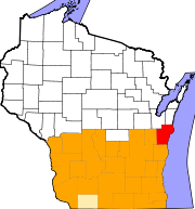
Wisconsin Governor Jim Doyle
declared a state of emergency in thirty counties on June 9 due to the flooding. The Federal Emergency Management Agency
(FEMA) inspectors are due to examine areas that suffered the most damage.
Continued heavy rains in the Wisconsin Dells
led to the Dell creek bypassing the dam holding Lake Delton
. On June 9, water rushing out of the lake eroded a section of County Highway A and washed away three homes and tore apart several others. The lake is now nearly empty and the escaping flood water created a new channel for the Wisconsin River
about a quarter mile away from the dam.
Wisconsin National Guard engineers began repairs on the dam the same day, but with the breach being about 400 feet (121.9 m) wide, the repairs were expected to be completed for over a year. However, as Governor Jim Doyle
called the lake critical to the $1 billion Wisconsin Dells tourism industry, he said the Department of Natural Resources was trying to figure out how to get the water flowing in the man-made lake. Already, there are tourists who had made summer reservations at the lake’s twenty resorts who have been canceling their reservations. The response of the local businesses have been varied. The Delton Oaks Resort, a 60-year operation, will be closing. Meanwhile, the iconic Wisconsin Dells boat tours are reopening despite the low water level. The Tommy Bartlett Show is going to continue, though the waterskiing aspect will be discarded at least until the lake is refilled.
 In southwestern Wisconsin, the Kickapoo River
rose several feet above flood stage, destroying most of the village of Gays Mills. Gays Mills had already been badly flooded in the August 2007 floods. Officials said Kickapoo River flood damage in Vernon County
likely will exceed the $60 million damage caused by the August 2007 floods, and already the water was two feet higher than the high water mark
of a historic 1978 flood. In the early morning of June 9, 150 residents in the village of 625 were forced to evacuate. Ontario
, Hillsboro
, La Farge
, and Viola
were also severely flooded, much worse than in August 2007. The county took an average of 9 inches (228.6 mm) of rain over the second weekend, causing mudslides and closing over 100 roads in Vernon, but the rain relented on Monday, June 16th. More thunderstorms, and more severe flooding, were expected in both Vernon and Crawford counties later that week. All the nearby dams held, though many sustained damage.
 Westbound lanes of Interstate 94
were closed between Johnson Creek and Lake Mills
on June 10, 2008 at 7 PM because of the rising Rock River
. Eastbound lanes of Interstate 90
/Interstate 94 were closed between WIS 82 in Juneau County
and WIS 33 west of Portage
. Also, Interstate 39 was closed in two places: Northbound at its interchange with I-90/94 and WIS 78, and southbound between WIS 82 and WIS 33. The closure of I-94 westbound in Jefferson County was extended eastward to WIS 83 in Waukesha County
. The closure of the interstates around Portage were extended southward to US 151 east of Madison.
The first reported fatality due to flooding in the state was confirmed June 14 in Waukesha County
. 68-year-old Robert Schaf was found near his car on a flooded road in the town of Summit
. Authorities report he died after being stranded on a flooded road, and was found in at least three feet of water.
Flooding also affected the communities on the Baraboo River
. The town of North Freedom
had all but one road into town closed because of flooding. The flooding forced the closure of the Mid-Continent Railway Museum
.
On June 14, federal disaster aid from FEMA was authorized under a major disaster declaration issued for the state by President George W. Bush
. Federal funding was made available to affected individuals in Columbia
, Crawford, Milwaukee, Sauk
, and Vernon
counties. Continuing damage surveys were conducted, especially in the southeast, and Wisconsin's inhabitants were reassured that other counties would be allowed to receive assistance. Richland and Racine counties were declared disaster area
s on June 16. On June 18, the President put five more counties under disaster area status, allowing Dodge
, Green
, Waukesha
, Washington, and Winnebago
. At the time of the announcement, the first 7 counties had already received almost $38,000 in FEMA aid.
The rainfall in southeastern Wisconsin was anywhere from 6 to 12 inches in the string of thunderstorms. Waukesha County had up to 8 inches in certain areas. As of June 19, municipal estimates for Waukesha County was $87.7 million, $3.2 million more than earlier in the week, though the total remains fluid.
The Rock and Crawfish rivers were still above flood stage in Jefferson and Rock counties into mid-July.
In late 2009, $6 million in federal aid was made available to victims in the 30-county area of Southern Wisconsin declared a disaster area by FEMA. Information on the 2008 Flood Recovery Program, which runs through September 30, 2010, is at www.2008floodrecovery.org.
Levee
A levee, levée, dike , embankment, floodbank or stopbank is an elongated naturally occurring ridge or artificially constructed fill or wall, which regulates water levels...
s at numerous locations. Flooding continued into July. States
U.S. state
A U.S. state is any one of the 50 federated states of the United States of America that share sovereignty with the federal government. Because of this shared sovereignty, an American is a citizen both of the federal entity and of his or her state of domicile. Four states use the official title of...
affected by the flooding included Illinois
Illinois
Illinois is the fifth-most populous state of the United States of America, and is often noted for being a microcosm of the entire country. With Chicago in the northeast, small industrial cities and great agricultural productivity in central and northern Illinois, and natural resources like coal,...
, Indiana
Indiana
Indiana is a US state, admitted to the United States as the 19th on December 11, 1816. It is located in the Midwestern United States and Great Lakes Region. With 6,483,802 residents, the state is ranked 15th in population and 16th in population density. Indiana is ranked 38th in land area and is...
, Iowa
Iowa
Iowa is a state located in the Midwestern United States, an area often referred to as the "American Heartland". It derives its name from the Ioway people, one of the many American Indian tribes that occupied the state at the time of European exploration. Iowa was a part of the French colony of New...
, Michigan
Michigan
Michigan is a U.S. state located in the Great Lakes Region of the United States of America. The name Michigan is the French form of the Ojibwa word mishigamaa, meaning "large water" or "large lake"....
, Minnesota
Minnesota
Minnesota is a U.S. state located in the Midwestern United States. The twelfth largest state of the U.S., it is the twenty-first most populous, with 5.3 million residents. Minnesota was carved out of the eastern half of the Minnesota Territory and admitted to the Union as the thirty-second state...
, Missouri
Missouri
Missouri is a US state located in the Midwestern United States, bordered by Iowa, Illinois, Kentucky, Tennessee, Arkansas, Oklahoma, Kansas and Nebraska. With a 2010 population of 5,988,927, Missouri is the 18th most populous state in the nation and the fifth most populous in the Midwest. It...
, and Wisconsin
Wisconsin
Wisconsin is a U.S. state located in the north-central United States and is part of the Midwest. It is bordered by Minnesota to the west, Iowa to the southwest, Illinois to the south, Lake Michigan to the east, Michigan to the northeast, and Lake Superior to the north. Wisconsin's capital is...
. The American Red Cross
American Red Cross
The American Red Cross , also known as the American National Red Cross, is a volunteer-led, humanitarian organization that provides emergency assistance, disaster relief and education inside the United States. It is the designated U.S...
assisted the victims of flooding and tornadoes across seven states and the National Guard was mobilized to assist in disaster relief and evacuation.
Flooding continued as long as two weeks with central Iowa
Iowa
Iowa is a state located in the Midwestern United States, an area often referred to as the "American Heartland". It derives its name from the Ioway people, one of the many American Indian tribes that occupied the state at the time of European exploration. Iowa was a part of the French colony of New...
and Cedar Rapids being hardest hit. The upper Mississippi Valley experienced flooding in Missouri
Missouri
Missouri is a US state located in the Midwestern United States, bordered by Iowa, Illinois, Kentucky, Tennessee, Arkansas, Oklahoma, Kansas and Nebraska. With a 2010 population of 5,988,927, Missouri is the 18th most populous state in the nation and the fifth most populous in the Midwest. It...
and Illinois
Illinois
Illinois is the fifth-most populous state of the United States of America, and is often noted for being a microcosm of the entire country. With Chicago in the northeast, small industrial cities and great agricultural productivity in central and northern Illinois, and natural resources like coal,...
as the region's estuaries drained the floodwater into the river. The flood left thirteen dead and damage region-wide was estimated to be in the tens of billions of dollars.
Illinois
On June 11, Illinois Governor Rod BlagojevichRod Blagojevich
Rod R. Blagojevich is an American politician who served as the 40th Governor of Illinois from 2003 to 2009. A Democrat, Blagojevich was a State Representative before being elected to the United States House of Representatives representing parts of Chicago...
deemed Clark, Coles
Coles County, Illinois
Coles County is a county located in the U.S. state of Illinois. According to the 2010 census, it has a population of 53,873, which is an increase of 1.3% from 53,196 in 2000. Its county seat is Charleston, which is also the home of Eastern Illinois University....
, Crawford, Cumberland, Jasper
Jasper County, Illinois
hjsdgcbi76dft...
and Lawrence counties as disaster areas. Levee breaks on June 10 flooded portions of Lawrence County near Lawrenceville
Lawrenceville, Illinois
Lawrenceville is a city in Lawrence County, Illinois, along the Embarras River. The population was 4,745 at the 2000 census. It is the county seat of Lawrence County...
, inundating a campsite and forcing the evacuations of 200 homes.
On June 14 many communities located along the Mississippi River in West Central Illinois were notified by the National Weather Service that crests along the river would exceed the record crests of 1993.
On the early morning of June 14, the town of Oquawka, Illinois
Oquawka, Illinois
Oquawka is a village in Henderson County, Illinois, United States. The population was 1,539 at the 2000 census. It is the county seat of Henderson County.Oquawka is part of the Burlington, IA–IL Micropolitan Statistical Area.-Geography:...
was evacuated, due to a levee breach
Levee breach
A levee breach or levee failure is a situation where a levee fails or is intentionally breached, causing the previously contained water to flood the land behind the levee.-Causes of failure:...
along the swollen Iowa River
Iowa River
The Iowa River is a tributary of the Mississippi River in the state of Iowa in the United States. It is about long and is open to small river craft to Iowa City, about from its mouth...
. The city council believed this would affect the flood waters in the already flooding Mississippi River
Mississippi River
The Mississippi River is the largest river system in North America. Flowing entirely in the United States, this river rises in western Minnesota and meanders slowly southwards for to the Mississippi River Delta at the Gulf of Mexico. With its many tributaries, the Mississippi's watershed drains...
. The same day two levees broke near the town of Keithsburg, Illinois
Keithsburg, Illinois
Keithsburg is a city in Mercer County, Illinois, United States. The population was 714 at the 2000 census.-Geography:Keithsburg is located at ....
, flooding the entire town.
On the morning of June 15, a levee along the Mississippi River
Mississippi River
The Mississippi River is the largest river system in North America. Flowing entirely in the United States, this river rises in western Minnesota and meanders slowly southwards for to the Mississippi River Delta at the Gulf of Mexico. With its many tributaries, the Mississippi's watershed drains...
in the town of Gulfport
Gulf Port, Illinois
Gulf Port is a village in Henderson County, Illinois, in the United States. As of the 2000 census, the village population was 207. It is part of the Burlington, IA–IL Micropolitan Statistical Area. The village was completely submerged, save the roofs of some homes and buildings, by a levee...
failed, flooding most of the town. Two more levees were breached by flood waters in western Illinois on June 18. The breaches flooded farmland near Meyer
Meyer, Illinois
Meyer is an unincorporated community in Adams County, Illinois, United States. It has a population of approximately 10 full time residents as of mid-2009, due to the flood of 2008. The community is part of the Quincy, IL–MO Micropolitan Statistical Area...
and forced an evacuation of the town.
More than $7.2 million in federal disaster assistance grants and loans were approved by the Federal Emergency Management Agency
Federal Emergency Management Agency
The Federal Emergency Management Agency is an agency of the United States Department of Homeland Security, initially created by Presidential Reorganization Plan No. 1 of 1978 and implemented by two Executive Orders...
and the U.S. Small Business Administration for Illinois residents who suffered damages and losses.
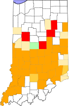
Indiana
Central and southwestern Indiana was particularly hard hit by flooding along the Ohio River and its tributaries; damages were expected to make the flooding the costliest disaster in the history of the state. Starting on June 4, 2008, rain soaked parts of south-central Indiana, leading to initial floods in and around BloomingtonBloomington, Indiana
Bloomington is a city in and the county seat of Monroe County in the southern region of the U.S. state of Indiana. The population was 80,405 at the 2010 census....
. Additional rain on June 7 brought the worst of the flooding to larger portions of south-central and western Indiana. The highest recorded rainfall was in the town of Edinburgh
Edinburgh, Indiana
Edinburgh is a town in Bartholomew, Johnson, and Shelby Counties in the U.S. state of Indiana. The population was 4,480 at the 2010 census. It is part of the Columbus, Indiana metropolitan statistical area. Edinburgh was named in honor of Edinburgh, Scotland and for many years was pronounced the...
, which saw 10.94 inches (277.9 mm) of rain in seven hours. Paragon
Paragon, Indiana
Paragon is a town in Ray Township, Morgan County, Indiana, United States. The population was 659 at the 2010 census.-Geography:Paragon is located at ....
had 10 inches (254 mm) of rain in just a few hours, leaving 90% of the town underwater.
Some parts of the state had flood levels exceeding records set in 1913. On June 9, President
President of the United States
The President of the United States of America is the head of state and head of government of the United States. The president leads the executive branch of the federal government and is the commander-in-chief of the United States Armed Forces....
George W. Bush
George W. Bush
George Walker Bush is an American politician who served as the 43rd President of the United States, from 2001 to 2009. Before that, he was the 46th Governor of Texas, having served from 1995 to 2000....
declared 29 counties in central Indiana a major disaster area, enabling the region to receive federal aid and Federal Emergency Management Agency
Federal Emergency Management Agency
The Federal Emergency Management Agency is an agency of the United States Department of Homeland Security, initially created by Presidential Reorganization Plan No. 1 of 1978 and implemented by two Executive Orders...
assistance.
Impact
Many low-lying areas of central and northern Indiana were evacuated because of the rapid rise of the waters. Indiana GovernorGovernor of Indiana
The Governor of Indiana is the chief executive of the state of Indiana. The governor is elected to a four-year term, and responsible for overseeing the day-to-day management of the functions of many agencies of the Indiana state government. The governor also shares power with other statewide...
Mitch Daniels
Mitch Daniels
Mitchell Elias "Mitch" Daniels, Jr. is the 49th and current Governor of the U.S. state of Indiana. A Republican, he began his first four-year term as governor on January 10, 2005, and was elected to his second term by an 18-point margin on November 4, 2008. Previously, he was the Director of the...
declared a state of emergency
State of emergency
A state of emergency is a governmental declaration that may suspend some normal functions of the executive, legislative and judicial powers, alert citizens to change their normal behaviours, or order government agencies to implement emergency preparedness plans. It can also be used as a rationale...
in 23 counties and called in the United States Coast Guard
United States Coast Guard
The United States Coast Guard is a branch of the United States Armed Forces and one of the seven U.S. uniformed services. The Coast Guard is a maritime, military, multi-mission service unique among the military branches for having a maritime law enforcement mission and a federal regulatory agency...
to assist in evacuations and rescues. The Coast Guard responded by sending two helicopters to the state along with boats and personnel. The Indiana National Guard
Indiana National Guard
The Indiana National Guard is the armed force of the state of Indiana. It consists of the Indiana Army National Guard and the Indiana Air National Guard, and is part of the larger Army National Guard and the Air National Guard...
was called out to assist in evacuation and direct traffic and enforce road blocks on the many flooded roads. Some areas of southern Indianapolis
Indianapolis
Indianapolis is the capital of the U.S. state of Indiana, and the county seat of Marion County, Indiana. As of the 2010 United States Census, the city's population is 839,489. It is by far Indiana's largest city and, as of the 2010 U.S...
, where the White River
White River (Indiana)
The White River is a two-forked river that flows through central and southern Indiana and is the main tributary to the Wabash River. Via the west fork, considered to be the main stem of the river by the U.S. Board on Geographic Names, the White River is long.-West Fork:The West Fork, long, is...
was several feet past flood stage, were evacuated. This included a hospital with one hundred patients and doctors. The Coast Guard continued to rescue trapped citizens on June 8. In Franklin, Indiana
Franklin, Indiana
As of the census of 2000, there were 19,463 people, 6,824 households, and 4,872 families residing in the city. The population increased by more than 50% during the 1990s , with new residents attracted by jobs in the community, as well as some people commuting to Indianapolis for work. The...
water rose as high as the first floor of Johnson Memorial Hospital. Doctors and patients were also evacuated from Columbus Regional Hospital in Columbus, Indiana
Columbus, Indiana
Columbus is a city in and the county seat of Bartholomew County, Indiana, United States. The population was 44,061 at the 2010 census, and the current mayor is Fred Armstrong. Located approximately 40 miles south of Indianapolis, on the east fork of the White River, it is the state's 20th largest...
. The hospital had to remain closed for an extended period of time because of power outages, generator failures, and extensive flood damage. It was expected to resume operations between September and December 2008, although emergency services began more quickly. All patients were evacuated and moved to nearby hospitals. One hundred and fifty people were evacuated from a nursing home in Morgan County
Morgan County, Indiana
Morgan County is a county located in the U.S. state of Indiana. As of 2010, the population was 68,894. The county seat is Martinsville. Morgan is one of seven counties contiguous to Marion County, and is located between Indianapolis, in Marion County, and Bloomington, located in Monroe County...
.
Nineveh, Indiana
Nineveh is an unincorporated community in Nineveh Township, Johnson County, Indiana, United States. Scenes from the movie Hoosiers were shot in the old high school which was renamed "Hickory High School" for the film....
. On June 8 the Wabash Valley
Wabash Valley
The Wabash Valley is a region with parts in both Illinois and Indiana. It is named for the Wabash River and spans the middle to the middle-lower portion of the river and is centered at Terre Haute, Indiana...
between Lafayette and Terre Haute, Indiana
Terre Haute, Indiana
Terre Haute is a city and the county seat of Vigo County, Indiana, United States, near the state's western border with Illinois. As of the 2010 census, the city had a total population of 60,785 and its metropolitan area had a population of 170,943. The city is the county seat of Vigo County and...
was placed under flood alert; all residents near the Wabash River
Wabash River
The Wabash River is a river in the Midwestern United States that flows southwest from northwest Ohio near Fort Recovery across northern Indiana to southern Illinois, where it forms the Illinois-Indiana border before draining into the Ohio River, of which it is the largest northern tributary...
were urged to evacuate their homes.
Looting
Looting
Looting —also referred to as sacking, plundering, despoiling, despoliation, and pillaging—is the indiscriminate taking of goods by force as part of a military or political victory, or during a catastrophe, such as during war, natural disaster, or rioting...
was reported in Seymour, Indiana
Seymour, Indiana
Seymour was the site of the World's First Train Robbery, committed by the local Reno Gang, on October 6, 1866 just east of town. The gang was put into prison for the robbery, and later hanged at Hangman's Crossing outside of town....
where the White River
White River (Indiana)
The White River is a two-forked river that flows through central and southern Indiana and is the main tributary to the Wabash River. Via the west fork, considered to be the main stem of the river by the U.S. Board on Geographic Names, the White River is long.-West Fork:The West Fork, long, is...
had overflowed its banks and forced the evacuation of over one hundred homes. Governor Daniels dispatched extra state police to the city to curb the looting. On June 10, five hundred members of the Kentucky National Guard
Kentucky National Guard
The Kentucky National Guard consists of the:*Kentucky Army National Guard*Kentucky Air National Guard-External links:** compiled by the United States Army Center of Military History...
were mobilized to assist Indiana in coping with the flood damage and rescuing stranded citizens. The same day floodwaters rose above record levels in at least five localities. In others the rising waters were near or at the historic 1913 flood levels. The flooding was the worst in Indiana's modern history, according to Scott Morlock, a hydrologist with the U.S. Geological Survey in Indiana.
Many roads were closed because of high water, including Interstate 65
Interstate 65
Interstate 65 is a major Interstate Highway in the United States. The southern terminus is located at an intersection with Interstate 10 in Mobile, Alabama, and its northern terminus is at an interchange with Interstate 90 , U.S. Route 12, and U.S...
, which was closed southbound at the interchange with Interstate 465
Interstate 465
Interstate 465 , also known as the USS Indianapolis Memorial Highway, is the beltway circling Indianapolis, Indiana, United States. It is roughly rectangular in shape and has a perimeter of approximately 53 miles . It lies almost completely within the boundaries of Marion County, except for two...
through Seymour. On June 16 Ball State University
Ball State University
Ball State University is a state-run research university located in Muncie, Indiana. It is also known as Ball State or simply BSU.Located on the northwest side of the city, Ball State's campus spans and includes 106 buildings...
released a report estimating that preliminary damages in the state would cost at least $126 million, with $45.8 million in damage to public infrastructure and the rest damage to private businesses and homes. Although damage estimates are likely to be revised upward, the current estimate ranks the flood as the second costliest in Indiana history. Governor Mitch Daniels said the state is compiling its own thorough estimates, with total damages expected to top $1 billion. This would include agricultural costs (of over $800 million) and clean-up efforts not included in the Ball State University Study. The agricultural damages from this flood event varied dramatically since the timing of the flood permitted extensive replanting. The joint Ball State University and University of Tennessee study by Mark Burton and Michael J. Hicks
Michael J. Hicks
Michael J. Hicks is an economist and columnist. He is currently the director of the Center for Business and Economic Research and Associate Professor of Economics at Ball State University..-Early Life & Military Career:...
excluded not only agricultural damage in Indiana, but also did not include any alrge public structures (e.g. hospitals) located in flood plains.
Deaths
One man drowned in flood waters near Remington, IndianaRemington, Indiana
Remington is a town in Carpenter Township, Jasper County, Indiana, United States. The population was 1,185 at the 2010 census.-History:Remington was first laid out in 1860 by Jesse H. Fordice. It was originally called Carpenter Station, after Carpenter's Creek where a railroad station had been...
.
Two deaths were reported in Columbus, Indiana
Columbus, Indiana
Columbus is a city in and the county seat of Bartholomew County, Indiana, United States. The population was 44,061 at the 2010 census, and the current mayor is Fred Armstrong. Located approximately 40 miles south of Indianapolis, on the east fork of the White River, it is the state's 20th largest...
. The first was confirmed by the Department of Homeland Security on June 8. On June 9, the body of a Cummins
Cummins
Cummins Inc. is a Fortune 500 corporation that designs, manufactures, distributes and services engines and related technologies, including fuel systems, controls, air handling, filtration, emission control and electrical power generation systems...
employee was discovered a mile from where he was sighted swept away by floodwaters.
Iowa
Severe flooding in IowaIowa
Iowa is a state located in the Midwestern United States, an area often referred to as the "American Heartland". It derives its name from the Ioway people, one of the many American Indian tribes that occupied the state at the time of European exploration. Iowa was a part of the French colony of New...
led to evacuations of many homes. In eastern Iowa along the Iowa River
Iowa River
The Iowa River is a tributary of the Mississippi River in the state of Iowa in the United States. It is about long and is open to small river craft to Iowa City, about from its mouth...
and Cedar River, flooding was expected to exceed that of the Flood of 1993. Flooding also forced the closure of a number of roads throughout the state, reaching the point where travel was not advised in some parts of the state.
On Monday, June 9 the Upper Iowa River
Upper Iowa River
The Upper Iowa River is a tributary of the Mississippi River in the upper Midwest of the United States.Its headwaters are in southeastern Minnesota, in Mower County near the border with Iowa. It then flows through the Iowa counties of Howard, Winneshiek, and Allamakee, and finally into the Upper...
in Decorah
Decorah, Iowa
Decorah is a city in and the county seat of Winneshiek County, Iowa, United States. The population was 8,172 at the 2000 census. Decorah is located at the intersection of State Highway 9 and U.S...
flooded when a levee
Levee
A levee, levée, dike , embankment, floodbank or stopbank is an elongated naturally occurring ridge or artificially constructed fill or wall, which regulates water levels...
was breached. Up to 6 inches (152 mm) of rain had fallen in the 48 hours prior. The water flooded parts of the lower campus of Luther College
Luther College (Iowa)
Luther College is a four-year, residential liberal arts institution of the Evangelical Lutheran Church in America, located in Decorah, Iowa, USA...
, damaging athletic fields and the Regents Center. Winneshiek County
Winneshiek County, Iowa
-2010 census:The 2010 census recorded a population of 21,056 in the county, with a population density of . There were 8,721 housing units, of which 7,997 were occupied.-2000 census:...
officials called this the worst flood to occur in Decorah since the current levee system was put in place in the 1940s. Other portions of the city were flooded. For a time, worries of losing the sanitary sewer system led to a 'please don't flush' order; as of Friday, 13 June 2008, this order was withdrawn, but pleas for careful use remain in effect. Decorah and Winneshiek County
Winneshiek County, Iowa
-2010 census:The 2010 census recorded a population of 21,056 in the county, with a population density of . There were 8,721 housing units, of which 7,997 were occupied.-2000 census:...
now face a difficult cleanup.
Dorchester, Iowa
Dorchester is an unincorporated community in northwestern Allamakee County, Iowa, United States. It lies along local roads just off Iowa Highway 76, north of the city of Waukon, the county seat of Allamakee County. Its elevation is 738 feet . Although Dorchester is unincorporated, it has a...
, severe flooding was experienced. In particular, a trailer court sustained major damage.
Along the Mississippi River
Mississippi River
The Mississippi River is the largest river system in North America. Flowing entirely in the United States, this river rises in western Minnesota and meanders slowly southwards for to the Mississippi River Delta at the Gulf of Mexico. With its many tributaries, the Mississippi's watershed drains...
, flood waters were reaching near record levels. In Burlington
Burlington, Iowa
Burlington is a city in, and the county seat of Des Moines County, Iowa, United States. The population was 25,663 in the 2010 census, a decline from the 26,839 population in the 2000 census. Burlington is the center of a micropolitan area including West Burlington, Iowa and Middletown, Iowa and...
, the Mississippi reached three different crests, before hitting 22.3 feet (6.8 m) on June 10, the fourth highest stage in the city's history; as of June 15, the expected crest was supposed to be around the 25.8 feet (7.9 m) mark, which would make it the second worst flood in the city's history, surpassing 1993 by 0.7 foot (0.21336 m). This caused the Burlington Steamboat Days to cancel and close up three days early, the first such occurrence that the festival has closed more than one day early since its inception in 1962. Severe flooding caused the city to close off an entire section of the riverfront, from Main Street to the riverfront. By the morning of June 15, several streets within the city had been closed off, including the entire length of Front Street; a section of Main Street, between Division Street, and Jefferson Street; a section of Mill Dam Road; Tama Road and all of its side roads; and County Highway 99. U.S. Highway 61, five miles (8 km) south of the city, had been closed on the morning of June 13 due to the rising waters of the Skunk River
Skunk River
The Skunk River is a tributary of the Mississippi River in the state of Iowa in the United States.It rises in two branches, the South Skunk and the North Skunk . The headwaters of the South Skunk are in Hamilton County in north central Iowa. It flows roughly due southward, to the west of...
.
Along the upper Turkey River, the historic towns of Spillville
Spillville, Iowa
Spillville is a city in Winneshiek County, Iowa, United States. The population was 386 at the 2000 census. It is located in Calmar Township, about west of Calmar and about southwest of Decorah, the county seat.-History:...
and Fort Atkinson
Fort Atkinson, Iowa
Fort Atkinson is a city in Winneshiek County, Iowa, United States. The population was 389 at the 2000 census. It is home to the historic Fort Atkinson State Preserve and hosts a large annual fur-trapper rendezvous each September...
experienced significant flooding, with damaged roads and bridge approaches. Further downstream, portions of Elkader
Elkader, Iowa
Elkader is a city in Clayton County, Iowa, United States. The population was 1,465 at the 2000 census. It is the county seat of Clayton County.-History:The city is named after Algerian leader Abd al-Qadir al-Jaza'iri...
were under water; the river had retreated by Thursday, June 12.
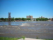
In Cedar Rapids
Cedar Rapids, Iowa
Cedar Rapids is the second largest city in Iowa and is the county seat of Linn County. The city lies on both banks of the Cedar River, north of Iowa City and east of Des Moines, the state's capital and largest city...
, officials were readying residents and downtown business owners to evacuate as the Cedar River threatened to spill over a levee. The river was expected to top the levee June 11, prompting a mandatory evacuation of downtown. All of the bridges over the Cedar River in downtown Cedar Rapids were closed at 8:00 pm CDT (0100 UTC) on June 11. On June 12, a levee broke, a railroad bridge owned by the Cedar Rapids and Iowa City Railway
Cedar Rapids and Iowa City Railway
The Cedar Rapids and Iowa City Railway , also known as the Crandic is a Class III railroad operating in the US state of Iowa.-History:...
was swept away along with loaded rail cars (which had been filled with rock in an attempt to keep the bridge in place, or failing that, cause it to sink to the bottom very close to its original location), 100 city blocks were submerged downtown, and 10,000 people were evacuated. In Waterloo
Waterloo, Iowa
Waterloo is a city in and the county seat of Black Hawk County, Iowa, United States. As of the 2010 United States Census the population decreased by 0.5% to 68,406. Waterloo is part of the Waterloo – Cedar Falls Metropolitan Statistical Area, and is the more populous of the two...
, fast-moving water swept away a railroad bridge used to transport tractors from a John Deere factory to Cedar Rapids. It also prompted the city to shut its downtown and close five bridges. The Black Hawk County Emergency Management Agency recommended the evacuation of the Cedar Terrace Neighborhood in Southeast Waterloo on June 10. Because of the severe flooding in east-central Iowa, officials with U.S. Postal Service's Des Moines-based Hawkeye District suspended all Retail, Post Office Box and Mail Caller Services at the Waterloo Main Post Office.
On June 12, a mandatory evacuation was issued for the Normandy Drive area of Iowa City
Iowa City, Iowa
Iowa City is a city in Johnson County, State of Iowa. As of the 2010 Census, the city had a total population of about 67,862, making it the sixth-largest city in the state. Iowa City is the county seat of Johnson County and home to the University of Iowa...
. An evacuation of two streets in Coralville
Coralville, Iowa
Coralville is a city in Johnson County, Iowa, United States. It is a suburb of Iowa City and part of the Iowa City Metropolitan Statistical Area...
was also issued, with the expectations of completing it by 5:00 pm CDT (2200 UTC) on June 12. One person died in the Iowa flooding. A section of Interstate 80
Interstate 80
Interstate 80 is the second-longest Interstate Highway in the United States, following Interstate 90. It is a transcontinental artery running from downtown San Francisco, California to Teaneck, New Jersey in the New York City Metropolitan Area...
was closed in Cedar County
Cedar County, Iowa
-2010 census:The 2010 census recorded a population of 13,956 in the county, with a population density of . There were 8,064 housing units, of which 7,511 were occupied.-2000 census:...
due to flooding.
The small town of Palo
Palo, Iowa
Palo is a city in Linn County, Iowa, United States. The population was 614 at the 2000 census; a special census in 2006 counted 899 residents. It is part of the Cedar Rapids Metropolitan Statistical Area....
, just upstream from Cedar Rapids, and home of Iowa's only nuclear power plant, underwent a mandatory evacuation. The town remained under water until June 13, 2008.
At 3:43am on the morning of June 14, the National Weather Service in Des Moines Iowa issued a Flash Flood Warning for the City of Des Moines
Des Moines, Iowa
Des Moines is the capital and the most populous city in the US state of Iowa. It is also the county seat of Polk County. A small portion of the city extends into Warren County. It was incorporated on September 22, 1851, as Fort Des Moines which was shortened to "Des Moines" in 1857...
due to a 50 feet (15.2 m) wide levee breach along the Des Moines River
Des Moines River
The Des Moines River is a tributary river of the Mississippi River, approximately long to its farther headwaters, in the upper Midwestern United States...
in Des Moines near Birdland Park between 6th Avenue and New York Avenue.
In the evening of June 14, a levee along the Iowa River
Iowa River
The Iowa River is a tributary of the Mississippi River in the state of Iowa in the United States. It is about long and is open to small river craft to Iowa City, about from its mouth...
near Oakville, Iowa
Oakville, Iowa
Oakville is a city in Louisa County, Iowa, United States. The population was 439 at the 2000 census. It is part of the Muscatine Micropolitan Statistical Area.-Geography:Oakville is located at ....
failed, causing the swollen waters to rampage through, two days before the mandatory evacuation deadline in the town of Oakville. This also caused evacuation in the Huron Township area. Also, during that same time, an area of the city of Burlington, Iowa
Burlington, Iowa
Burlington is a city in, and the county seat of Des Moines County, Iowa, United States. The population was 25,663 in the 2010 census, a decline from the 26,839 population in the 2000 census. Burlington is the center of a micropolitan area including West Burlington, Iowa and Middletown, Iowa and...
was evacuated, along Tama Road, due to a levee problem along the swollen Mississippi River
Mississippi River
The Mississippi River is the largest river system in North America. Flowing entirely in the United States, this river rises in western Minnesota and meanders slowly southwards for to the Mississippi River Delta at the Gulf of Mexico. With its many tributaries, the Mississippi's watershed drains...
; the levee began to bulge and was threatening to fail by mid afternoon. By nightfall, it was still holding, but hopes were not high that it would remain intact; this caused Des Moines County to issue an evacuation order for all residents of the county that live east of County Highway 99. By the morning of June 15, the entire length of County Highway 99 within Des Moines County had been closed. By the morning of June 16, three more bulges were discovered along the levee, prompting workers to state that it was no longer a question of if but when the levee would fail. On June 16, Cedar, Jones
Jones County, Iowa
-2010 census:The 2010 census recorded a population of 20,638 in the county, with a population density of . There were 8,911 housing units, of which 8,151 were occupied.-2000 census:...
, Louisa
Louisa County, Iowa
-2010 census:The 2010 census recorded a population of 11,387 in the county, with a population density of . There were 5,002 housing units, of which 4,346 were occupied.-2000 census:...
, Muscatine
Muscatine County, Iowa
-2010 census:The 2010 census recorded a population of 42,745 in the county, with a population density of . There were 17,910 housing units, of which 16,412 were occupied.-2000 census:...
, Polk
Polk County, Iowa
Polk County is a county located in the U.S. state of Iowa. The population was 430,640 in the 2010 census, an increase from 374,601 in the 2000 census. The county seat is Des Moines, which is also the capital city of Iowa...
, and Winneshiek Counties were approved for federal individual assistance.
Michigan
Several tornadoes touched down in southern MichiganMichigan
Michigan is a U.S. state located in the Great Lakes Region of the United States of America. The name Michigan is the French form of the Ojibwa word mishigamaa, meaning "large water" or "large lake"....
and flooding led to evacuation of many homes. At least eight people died, due to a combination of blowing debris, flooding, and infrastructure failures. On June 14th a State of Emergency
State of emergency
A state of emergency is a governmental declaration that may suspend some normal functions of the executive, legislative and judicial powers, alert citizens to change their normal behaviours, or order government agencies to implement emergency preparedness plans. It can also be used as a rationale...
is declared for the counties of Allegan
Allegan County, Michigan
-Interstates:* I-196* I-196 Business Loop serves the city of Holland.-US highways:* US-31* US-131-Michigan State Trunklines:* M-40* M-89* M-179* M-222-Allegan County Intercounty Highways:* A-2* A-37* A-42* A-45-Demographics:...
, Eaton
Eaton County, Michigan
Eaton County is a county in the U.S. state of Michigan. As of the 2010 census, the population was 107,759. The county seat is Charlotte. Eaton County was named for John Eaton, who was Secretary of War under U.S. President Andrew Jackson, making it one of Michigan's Cabinet counties...
, and Mason
Mason County, Michigan
Mason County is a county in the U.S. state of Michigan. As of the 2010 census, the population was 28,705. The county seat is Ludington.-History:...
. In days leading up to the State of Emergency, 8 to 11 inches (279.4 mm) of rain has fallen and winds have been recorded at 98 miles per hour across the area. Officials in Allegan County are expecting to spend nearly $700,000 to repair collapsed roads. More than 50 roads in Mason County are closed due to severe damage, as well as several miles of US-10 and US-31. In the City of Ludington
Ludington, Michigan
Ludington is a city in the U.S. state of Michigan. As of the 2000 census, the city population was 8,357. It is the county seat of Mason County.Ludington is a harbor town located on Lake Michigan at the mouth of the Pere Marquette River...
damage to the city's public utilities has left many without drinking water and sewage contamination in the area.
Minnesota
Approximately 75 homes in Preston, MinnesotaPreston, Minnesota
Preston is a city in Fillmore County, Minnesota, United States. The population was 1,325 at the 2010 census. It is the county seat of Fillmore County. The Root River runs through it, and Mystery Cave State Park is nearby...
suffered water damage from excessive rainfall. Some residents were evacuated in Hayfield, Minnesota
Hayfield, Minnesota
Hayfield is a city in Dodge County, Minnesota, United States. The population was 1,340 at the 2010 census.-Geography:According to the United States Census Bureau, the city has a total area of , all of it land.-Transportation:...
after the Zumbro River
Zumbro River
The Zumbro River is a tributary of the Mississippi River in the Driftless Area of southeastern Minnesota in the United States. It is about 50 mi long from the confluence of its principal tributaries and drains a watershed of 1,428 sq mi...
flooded. The Cedar River also flooded which threatened to cause problems in Austin, Minnesota
Austin, Minnesota
As of the census of 2000, there were 23,314 people, 9,897 households, and 6,076 families residing in the city. The population density was 2,168.2 people per square mile . There were 10,261 housing units at an average density of 954.3 per square mile...
. One man died when his vehicle plunged into a flooded creek near Albert Lea
Albert Lea, Minnesota
Albert Lea is a city in and the county seat of Freeborn County in the southeastern part of the U.S. state of Minnesota. The population was 18,016 at the 2010 census....
.
Missouri
The deluge of storms led to a quick rise of water on the Mississippi RiverMississippi River
The Mississippi River is the largest river system in North America. Flowing entirely in the United States, this river rises in western Minnesota and meanders slowly southwards for to the Mississippi River Delta at the Gulf of Mexico. With its many tributaries, the Mississippi's watershed drains...
which saw water crest ten feet above flood stage in Hannibal, Missouri
Hannibal, Missouri
Hannibal is a city in Marion and Ralls counties in the U.S. state of Missouri. Hannibal is located at the intersection of Interstate 72 and U.S. Routes 24, 36 and 61, approximately northwest of St. Louis. According to the 2010 U.S. Census the population was 17,606...
on June 10. The National Weather Service predicted that the flood stage could be higher in the next two weeks. Most of the towns near the river are protected by levees, but outlying areas are vulnerable to flooding.
On June 27, 2008, muskrat
Muskrat
The muskrat , the only species in genus Ondatra, is a medium-sized semi-aquatic rodent native to North America, and introduced in parts of Europe, Asia, and South America. The muskrat is found in wetlands and is a very successful animal over a wide range of climates and habitats...
holes weakened a Mississippi River levee, allowing floodwaters to pour into Lincoln County, Missouri
Lincoln County, Missouri
As of the census of 2000, there were 38,944 people, 13,851 households, and 10,554 families residing in the county. The population density was 62 people per square mile . There were 15,511 housing units at an average density of 25 per square mile...
. The levee was the last one remaining in Lincoln County and was protecting about 100 homes. Sheriff's deputies alerted residents to evacuate. Sirens also went off to warn residents of the levee breach. Muskrats looking for food or making dens had dug into the levee, weakening it enough for the levee to breach.
Wisconsin
On June 7, at least six confirmed tornadoes touched down in multiple counties, as an effect of the strong winds of the daily storms.Wisconsin Governor Jim Doyle
Jim Doyle
James Edward "Jim" Doyle is a Wisconsin politician and member of the Democratic Party. He was the 44th Governor of Wisconsin, serving from January 6, 2003 to January 3, 2011. He defeated incumbent Governor Scott McCallum by a margin of 45 percent to 41 percent; the Libertarian Party candidate Ed...
declared a state of emergency in thirty counties on June 9 due to the flooding. The Federal Emergency Management Agency
Federal Emergency Management Agency
The Federal Emergency Management Agency is an agency of the United States Department of Homeland Security, initially created by Presidential Reorganization Plan No. 1 of 1978 and implemented by two Executive Orders...
(FEMA) inspectors are due to examine areas that suffered the most damage.
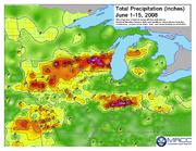
Continued heavy rains in the Wisconsin Dells
Wisconsin Dells, Wisconsin
Wisconsin Dells is a city in south-central Wisconsin, with a population of 2,418 as of the 2000 census. It straddles four counties: Adams, Columbia, Juneau, and Sauk. The city takes its name from the dells of the Wisconsin River, a scenic, glacially formed gorge that features striking sandstone...
led to the Dell creek bypassing the dam holding Lake Delton
Lake Delton
Lake Delton is a man-made freshwater lake in Sauk County in central Wisconsin. For much of 2008, it was a mostly empty lake basin after a portion of a county highway that forms part of the dike wall eroded on June 9, 2008, under the pressure of floods in the area. The resulting washout caused the...
. On June 9, water rushing out of the lake eroded a section of County Highway A and washed away three homes and tore apart several others. The lake is now nearly empty and the escaping flood water created a new channel for the Wisconsin River
Wisconsin River
-External links:* * * , Wisconsin Historical Society* * * *...
about a quarter mile away from the dam.
Wisconsin National Guard engineers began repairs on the dam the same day, but with the breach being about 400 feet (121.9 m) wide, the repairs were expected to be completed for over a year. However, as Governor Jim Doyle
Jim Doyle
James Edward "Jim" Doyle is a Wisconsin politician and member of the Democratic Party. He was the 44th Governor of Wisconsin, serving from January 6, 2003 to January 3, 2011. He defeated incumbent Governor Scott McCallum by a margin of 45 percent to 41 percent; the Libertarian Party candidate Ed...
called the lake critical to the $1 billion Wisconsin Dells tourism industry, he said the Department of Natural Resources was trying to figure out how to get the water flowing in the man-made lake. Already, there are tourists who had made summer reservations at the lake’s twenty resorts who have been canceling their reservations. The response of the local businesses have been varied. The Delton Oaks Resort, a 60-year operation, will be closing. Meanwhile, the iconic Wisconsin Dells boat tours are reopening despite the low water level. The Tommy Bartlett Show is going to continue, though the waterskiing aspect will be discarded at least until the lake is refilled.
Kickapoo River
The Kickapoo River is a tributary of the Wisconsin River in the state of Wisconsin, United States. It is named for the Kickapoo Indians who occupied Wisconsin before the influx of white settlers in the early 19th century.-Watershed:...
rose several feet above flood stage, destroying most of the village of Gays Mills. Gays Mills had already been badly flooded in the August 2007 floods. Officials said Kickapoo River flood damage in Vernon County
Vernon County, Wisconsin
Vernon County is a county in the U.S. state of Wisconsin. As of 2009, the population estimate was 29,324. Its county seat is Viroqua.-History:...
likely will exceed the $60 million damage caused by the August 2007 floods, and already the water was two feet higher than the high water mark
High water mark
High water mark may refer to:*Ordinary high water mark, a landscape marking such as floodwater staining left by the highest level of water...
of a historic 1978 flood. In the early morning of June 9, 150 residents in the village of 625 were forced to evacuate. Ontario
Ontario, Wisconsin
Ontario is a village in Vernon County, Wisconsin, United States. The population was 476 at the 2000 census.-Attractions:* Wildcat Mountain State Park is located near Ontario.The Kickapoo River is used for kayaking and canoeing.-Geography:...
, Hillsboro
Hillsboro, Wisconsin
Hillsboro is a city in Vernon County, Wisconsin, United States. The population was 1,302 at the 2000 census. The city is located within the Town of Hillsboro...
, La Farge
La Farge, Wisconsin
La Farge is a village along the Kickapoo River in Vernon County, Wisconsin, United States. The population was 775 at the 2000 census. The residential community of Dreamtime Village is located near LaFarge.-Transportation:...
, and Viola
Viola, Wisconsin
Viola is a village in Richland and Vernon Counties in the U.S. state of Wisconsin, United States. The population was 667 at the 2000 census.-Geography:Viola is located at ....
were also severely flooded, much worse than in August 2007. The county took an average of 9 inches (228.6 mm) of rain over the second weekend, causing mudslides and closing over 100 roads in Vernon, but the rain relented on Monday, June 16th. More thunderstorms, and more severe flooding, were expected in both Vernon and Crawford counties later that week. All the nearby dams held, though many sustained damage.
Interstate 94 in Wisconsin
In the U.S. state of Wisconsin, Interstate 94 runs east–west through the western, central and southeastern portions of the state.-Route description:A total of of Interstate 94 lie in Wisconsin....
were closed between Johnson Creek and Lake Mills
Lake Mills, Wisconsin
Lake Mills is a city in Jefferson County, Wisconsin, United States. The population was 4,843 at the 2000 census. The city is located partially within the Town of Lake Mills.-Geography:Lake Mills is located at ....
on June 10, 2008 at 7 PM because of the rising Rock River
Rock River (Illinois)
The Rock River is a tributary of the Mississippi River, approximately long, in the U.S. states of Wisconsin and Illinois. It rises in southeast Wisconsin, in the Theresa Marsh near Theresa, Wisconsin in northeast Dodge County, Wisconsin approximately south of Fond du Lac, Wisconsin...
. Eastbound lanes of Interstate 90
Interstate 90 in Wisconsin
In the U.S. state of Wisconsin, Interstate 90 runs east–west through the western, central and southern portions of the state. A total of of Interstate 90 lie in Wisconsin.-Route description:...
/Interstate 94 were closed between WIS 82 in Juneau County
Juneau County, Wisconsin
Juneau County is a county located in the U.S. state of Wisconsin. As of the 2000 census, the population was 24,316. Its county seat is Mauston. It should not, however, be confused with the city of Juneau, Wisconsin, to which it has no connection.-Geography:...
and WIS 33 west of Portage
Portage, Wisconsin
Portage is a city in and the county seat of Columbia County, Wisconsin, United States. The population was 10,662 at the 2010 census making it the largest city in Columbia County...
. Also, Interstate 39 was closed in two places: Northbound at its interchange with I-90/94 and WIS 78, and southbound between WIS 82 and WIS 33. The closure of I-94 westbound in Jefferson County was extended eastward to WIS 83 in Waukesha County
Waukesha County, Wisconsin
Waukesha County is a county in the U.S. state of Wisconsin. As of 2008, the population was 380,629. Its county seat is Waukesha.-History:The part of Wisconsin that Waukesha County now occupies was a part of Michigan when Milwaukee County was organized in September 1834. On July 4, 1836, the...
. The closure of the interstates around Portage were extended southward to US 151 east of Madison.
The first reported fatality due to flooding in the state was confirmed June 14 in Waukesha County
Waukesha County, Wisconsin
Waukesha County is a county in the U.S. state of Wisconsin. As of 2008, the population was 380,629. Its county seat is Waukesha.-History:The part of Wisconsin that Waukesha County now occupies was a part of Michigan when Milwaukee County was organized in September 1834. On July 4, 1836, the...
. 68-year-old Robert Schaf was found near his car on a flooded road in the town of Summit
Summit, Waukesha County, Wisconsin
Summit is a town in Waukesha County, Wisconsin, United States. The population was 4,999 at the 2000 census. The unincorporated communities of Summit Centter and Summit Corners are located in the town.-History:...
. Authorities report he died after being stranded on a flooded road, and was found in at least three feet of water.
Flooding also affected the communities on the Baraboo River
Baraboo River
The Baraboo River is a tributary of the Wisconsin River, about 70 mi long, in south-central Wisconsin in the United States. Via the Wisconsin River, it is part of the watershed of the Mississippi River....
. The town of North Freedom
North Freedom, Wisconsin
North Freedom is a village in Sauk County, Wisconsin, United States, along the Baraboo River. The population was 649 at the 2000 census.-Geography:North Freedom is located at ....
had all but one road into town closed because of flooding. The flooding forced the closure of the Mid-Continent Railway Museum
Mid-Continent Railway Museum
The Mid-Continent Railway Museum is a railroad museum in North Freedom, Wisconsin.-Collection:Three steam locomotives are currently under restoration to federal guidelines. The museum has 14 steam and 6 diesel locomotives including Chicago & North Western # 1385 and over 100 other pieces of...
.
On June 14, federal disaster aid from FEMA was authorized under a major disaster declaration issued for the state by President George W. Bush
George W. Bush
George Walker Bush is an American politician who served as the 43rd President of the United States, from 2001 to 2009. Before that, he was the 46th Governor of Texas, having served from 1995 to 2000....
. Federal funding was made available to affected individuals in Columbia
Columbia County, Wisconsin
-Unincorporated communities:*Anacker*Belle Fountain*Durwards Glen*East Friesland*Harmony Grove*Ingle*Keyeser*Lake Wisconsin*Leeds*Lowville*Marcellon*North Leeds*Okee*Otsego-External links:***...
, Crawford, Milwaukee, Sauk
Sauk County, Wisconsin
Sauk County is a county in the U.S. state of Wisconsin. As of 2000, the population was 55,225. Its county seat and largest city is Baraboo. Sauk County is included in the Baraboo Micropolitan Statistical Area and in the Madison Combined Statistical Area....
, and Vernon
Vernon County, Wisconsin
Vernon County is a county in the U.S. state of Wisconsin. As of 2009, the population estimate was 29,324. Its county seat is Viroqua.-History:...
counties. Continuing damage surveys were conducted, especially in the southeast, and Wisconsin's inhabitants were reassured that other counties would be allowed to receive assistance. Richland and Racine counties were declared disaster area
Disaster area
A disaster area is a region or a locale heavily damaged by either natural hazards, such as tornadoes, hurricanes, tsunamis, floods, earthquakes, technological hazards including nuclear and radiation accidents, or sociological hazards like riots, terrorism or war. The population living there often...
s on June 16. On June 18, the President put five more counties under disaster area status, allowing Dodge
Dodge County, Wisconsin
Dodge County is a county located in the U.S. state of Wisconsin. As of 2010, the population was 88,759. Its county seat is Juneau.-Geography:According to the U.S...
, Green
Green County, Wisconsin
Green County is a county located in the U.S. state of Wisconsin. As of 2000, the population was 33,647. Its county seat is Monroe.-Geography:According to the U.S...
, Waukesha
Waukesha County, Wisconsin
Waukesha County is a county in the U.S. state of Wisconsin. As of 2008, the population was 380,629. Its county seat is Waukesha.-History:The part of Wisconsin that Waukesha County now occupies was a part of Michigan when Milwaukee County was organized in September 1834. On July 4, 1836, the...
, Washington, and Winnebago
Winnebago County, Wisconsin
Winnebago County is a county in the U.S. state of Wisconsin. As of 2009, the population estimate was 163,370. Its county seat is Oshkosh. Winnebago County is included in the Oshkosh, Wisconsin-Neenah, Wisconsin, Metropolitan Statistical Area.-Geography:...
. At the time of the announcement, the first 7 counties had already received almost $38,000 in FEMA aid.
The rainfall in southeastern Wisconsin was anywhere from 6 to 12 inches in the string of thunderstorms. Waukesha County had up to 8 inches in certain areas. As of June 19, municipal estimates for Waukesha County was $87.7 million, $3.2 million more than earlier in the week, though the total remains fluid.
The Rock and Crawfish rivers were still above flood stage in Jefferson and Rock counties into mid-July.
In late 2009, $6 million in federal aid was made available to victims in the 30-county area of Southern Wisconsin declared a disaster area by FEMA. Information on the 2008 Flood Recovery Program, which runs through September 30, 2010, is at www.2008floodrecovery.org.
See also
- 2007 Midwest flooding2007 Midwest floodingThe 2007 Midwest flooding was a major flooding event that occurred in the Midwestern United States in the third week of August 2007. While Hurricane Dean was affecting the Yucatán Peninsula and the Gulf of Mexico, and Tropical Storm Erin was affecting Oklahoma and Texas, a persistent storm system...
- June 2008 tornado outbreak sequenceJune 2008 tornado outbreak sequenceThe June 2008 tornado outbreak sequence was a series of tornado outbreaks affecting most of central and eastern North America from June 3–11, 2008. 192 tornadoes were confirmed, along with widespread straight–line wind wind damage. Seven people were killed from a direct result of...
- March 2008 Midwest floodsMarch 2008 Midwest floodsThe March 2008 Midwest floods were a massive flooding event in the Southern Midwest and portions of the Southern Plains. Cape Girardeau, Missouri officially reported between March 18 and 19. At least 17 people died as a result of the flooding...
- Floods in the United States until 1900Floods in the United States until 1900Floods in the United States until 1900 is a list of significant floods which have struck the United States up to 1900. Floods are generally caused by excessive rainfall, excessive snowmelt, and dam failure...
- Floods in the United States: 1901-2000