
Des Moines River
Encyclopedia
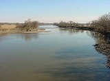
The Des Moines River is a tributary river of the Mississippi River
, approximately 525 miles (844.9 km) long to its farther headwaters, in the upper Midwestern United States
. The largest river flowing across the state of Iowa
, it rises in southern Minnesota
, and flows across Iowa from northwest to southeast, passing from the glaciated
plains into the unglaciated hills near the city of Des Moines
, which takes its name from the river. It forms a short portion of Iowa's border with Missouri
in Lee County
. The Avenue of the Saints
passes over this section.
in Murray County
in southwestern Minnesota. It flows south-southeast into Emmet County, Iowa
, past Estherville
. The East Fork rises out of Okamanpeedan Lake
in northern Emmet County on the Iowa-Minnesota border and flows south, through Algona
.
The two forks join in southern Humboldt County
, approximately 5 miles (8 km) south of Humboldt
at Frank Gotch
State Park
. The combined stream flows roughly southward through Fort Dodge
. South of Boone
it passes through the Ledges State Park
. It flows through downtown Des Moines, then turns generally southeastward, flowing through Ottumwa
. It forms approximately 20 miles (32 km) of the border between Iowa and Missouri before joining the Mississippi from the northwest at Keokuk
.
It receives the Boone River
from the northeast approximately 20 miles (32 km) southwest of Fort Dodge. It receives the Raccoon River from the west in Des Moines. Above the city of Des Moines, it is impounded to create the Saylorville Lake
reservoir. About midway below Saylorville and above Ottumwa, near Pella, it is impounded to create the Lake Red Rock
reservoir.
 One of the earliest French maps that depicts the Des Moines (1703) refers to it as "R. des Otentas" which translates to "River of the Otoe"; the Otoe Tribe
lived in the interior of Iowa in the 18th century. Another early name used by the Meskwaki
and Sauk was "Ke-o-shaw-qua", (lit. Hermit's River) from which Keosauqua, Iowa
derives its name.
The origin of the name "Des Moines" is obscure. It was given the name La Rivière des Moines, literally meaning "River of the Monks", by early French
explorers. The name may have referred to early Trappist
monks who built huts near the mouth of the river. It may also refer to moingona, an American Indian
word meaning "river of the mounds" in reference to the burial mounds that were located near the banks of the river. The 1718 Guillaume Delisle
map (pictured) labels it "le Moingona R."
It is also claimed that the name "des Moines" is the result of a hoax
. In 1673 Father Jacques Marquette
met some representatives of the Peoria
tribe near the mouth of the modern-day Des Moines River. He asked them the name of the rival tribe that lived further along the banks of the river. The Peoria told him that tribe was called the Moingoana, which became the root for the word 'Moines'. But researcher Michael McCafferty of Indiana University
, while studying the now extinct Miami-Illinois language, discovered that Moingoana, translated literally, meant "shit faces".http://www.museumofhoaxes.com/hoax/weblog/permalink/the_true_meaning_of_des_moines/
During the mid-19th century, the river provided the main commercial transportation across Iowa until the building of the railroads in the 1860s.
 There has been a history of flooding from the river. For example, in May 1944 the Riverview Park had just opened for the season on May 19, 1944. At around dawn on May 23, the levee began to collapse. The river was too much to hold back. Quickly the breach in the levee grew to nearly 100 feet (30.5 m) wide, and the river water quickly enveloped all of the park and the surrounding area.
The Great Flood of 1993
on the river and its tributary the Raccoon in the summer of 1993 forced the evacuation of much of the city of Des Moines and nearby communities. On June 13, 2008, officials issued a voluntary evacuation order for much of downtown and other areas bordering the Des Moines River. The river had reached flood stage in many locations, and Mayor Frank Cownie said the evacuations were an attempt "to err on the side of citizens and residents."
, the Des Moines River has also been known as:
Mississippi River
The Mississippi River is the largest river system in North America. Flowing entirely in the United States, this river rises in western Minnesota and meanders slowly southwards for to the Mississippi River Delta at the Gulf of Mexico. With its many tributaries, the Mississippi's watershed drains...
, approximately 525 miles (844.9 km) long to its farther headwaters, in the upper Midwestern United States
Midwestern United States
The Midwestern United States is one of the four U.S. geographic regions defined by the United States Census Bureau, providing an official definition of the American Midwest....
. The largest river flowing across the state of Iowa
Iowa
Iowa is a state located in the Midwestern United States, an area often referred to as the "American Heartland". It derives its name from the Ioway people, one of the many American Indian tribes that occupied the state at the time of European exploration. Iowa was a part of the French colony of New...
, it rises in southern Minnesota
Minnesota
Minnesota is a U.S. state located in the Midwestern United States. The twelfth largest state of the U.S., it is the twenty-first most populous, with 5.3 million residents. Minnesota was carved out of the eastern half of the Minnesota Territory and admitted to the Union as the thirty-second state...
, and flows across Iowa from northwest to southeast, passing from the glaciated
Glacier
A glacier is a large persistent body of ice that forms where the accumulation of snow exceeds its ablation over many years, often centuries. At least 0.1 km² in area and 50 m thick, but often much larger, a glacier slowly deforms and flows due to stresses induced by its weight...
plains into the unglaciated hills near the city of Des Moines
Des Moines, Iowa
Des Moines is the capital and the most populous city in the US state of Iowa. It is also the county seat of Polk County. A small portion of the city extends into Warren County. It was incorporated on September 22, 1851, as Fort Des Moines which was shortened to "Des Moines" in 1857...
, which takes its name from the river. It forms a short portion of Iowa's border with Missouri
Missouri
Missouri is a US state located in the Midwestern United States, bordered by Iowa, Illinois, Kentucky, Tennessee, Arkansas, Oklahoma, Kansas and Nebraska. With a 2010 population of 5,988,927, Missouri is the 18th most populous state in the nation and the fifth most populous in the Midwest. It...
in Lee County
Lee County, Iowa
-2010 census:The 2010 census recorded a population of 35,862 in the county, with a population density of . There were 16,205 housing units, of which 14,610 were occupied.-2000 census:...
. The Avenue of the Saints
Avenue of the Saints
The Avenue of the Saints is a highway in the Midwestern United States that connects St. Paul, Minnesota, and St. Louis, Missouri.-Missouri:Within Missouri, the Avenue of the Saints is Interstate 64, U.S...
passes over this section.
Hydrography
The Des Moines River rises in two forks. The West Fork (the main branch) rises out of Lake ShetekLake Shetek
Lake Shetek is the largest lake in Murray County, Minnesota, located a few miles north-northwest of Currie. Shetek means "pelican".-Geography:...
in Murray County
Murray County, Minnesota
As of the census of 2000, there were 9,165 people, 3,722 households, and 2,601 families residing in the county. The population density was 13 people per square mile . There were 4,357 housing units at an average density of 6 per square mile...
in southwestern Minnesota. It flows south-southeast into Emmet County, Iowa
Emmet County, Iowa
-2010 census:The 2010 census recorded a population of 10,302 in the county, with a population density of . There were 4,758 housing units, of which 4,236 were occupied.-2000 census:...
, past Estherville
Estherville, Iowa
Estherville is a city in Emmet County, Iowa, United States. The population was 6,360 in the 2010 census, a decline from 6,656 in the 2000 census. It is the county seat of Emmet County. Estherville is home to the main campus of Iowa Lakes Community College...
. The East Fork rises out of Okamanpeedan Lake
Okamanpeedan Lake
Okamanpeedan Lake, partially located in Martin County, Minnesota, and Emmet County, Iowa, is also known as Tuttle Lake. Okamanpeedan Lake is a roughly 2,300-acre riverine lake located on the East Fork of the Des Moines River. It has an average depth of about four to six feet...
in northern Emmet County on the Iowa-Minnesota border and flows south, through Algona
Algona, Iowa
Algona is a city in and the county seat of Kossuth County, Iowa, United States. The population was 5,741 at the 2000 census. Ambrose A. Call State Park is located two miles southwest of the city.-History:...
.
The two forks join in southern Humboldt County
Humboldt County, Iowa
-2010 census:The 2010 census recorded a population of 9,815 in the county, with a population density of . There were 4,684 housing units, of which 4,209 were occupied.-2000 census:...
, approximately 5 miles (8 km) south of Humboldt
Humboldt, Iowa
Humboldt is a city in Humboldt County, Iowa, United States. The population was 4,690 at the 2010 census, gaining 238 people since the 2000 census.- History :...
at Frank Gotch
Frank Gotch
Frank Alvin Gotch was an American professional wrestler of German ancestry, the first American to win the world heavyweight free-style championship, and credited for popularizing professional wrestling in the United States...
State Park
State park
State parks are parks or other protected areas managed at the federated state level within those nations which use "state" as a political subdivision. State parks are typically established by a state to preserve a location on account of its natural beauty, historic interest, or recreational...
. The combined stream flows roughly southward through Fort Dodge
Fort Dodge, Iowa
Fort Dodge is a city and county seat of Webster County, Iowa, United States, along the Des Moines River. The population was 25,206 in the 2010 census, an increase from 25,136 in the 2000 census. Fort Dodge is a major commercial center for North Central and Northwest Iowa. It is located on U.S...
. South of Boone
Boone, Iowa
Boone is a city in and the county seat of Des Moines Township, Boone County, Iowa, United States. It is the principal city of the 'Boone, Iowa Micropolitan Statistical Area', which encompasses all of Boone County. This micropolitan statistical area, along with the 'Ames, Iowa Metropolitan...
it passes through the Ledges State Park
Ledges State Park
Ledges State Park is a state park of Iowa, USA, located approximately south of the city of Boone. The park contains a sandstone gorge carved by Pea's Creek, a tributary of the Des Moines River...
. It flows through downtown Des Moines, then turns generally southeastward, flowing through Ottumwa
Ottumwa, Iowa
Ottumwa is a city in and the county seat of Wapello County, Iowa, United States. The population was 24,998 at the 2000 census. It is located in the southeastern part of Iowa, and the city is split into northern and southern halves by the Des Moines River....
. It forms approximately 20 miles (32 km) of the border between Iowa and Missouri before joining the Mississippi from the northwest at Keokuk
Keokuk, Iowa
Keokuk is a city in the southeastern part of the U.S. state of Iowa and one of the county seats of Lee County. The other county seat is Fort Madison. The population was 11,427 at the 2000 census. The city is named after the Sauk Chief Keokuk, who is thought to be buried in Rand Park...
.
It receives the Boone River
Boone River
The Boone River is a tributary of the Des Moines River in north-central Iowa in the United States. It is long and drains an area of . Via the Des Moines River, it is part of the watershed of the Mississippi River....
from the northeast approximately 20 miles (32 km) southwest of Fort Dodge. It receives the Raccoon River from the west in Des Moines. Above the city of Des Moines, it is impounded to create the Saylorville Lake
Saylorville Lake
Saylorville Lake is a reservoir on the Des Moines River in Iowa. It is located upstream from the city of Des Moines, and from the mouth of the Des Moines River at the Mississippi River...
reservoir. About midway below Saylorville and above Ottumwa, near Pella, it is impounded to create the Lake Red Rock
Lake Red Rock (Des Moines River)
Originally the city of Red Rock, Lake Red Rock, also referred to as Red Rock Reservoir is a reservoir formed by Red Rock Dam on the Des Moines River, about 55 miles southeast of the city of Des Moines, Iowa. The dam was completed in 1969 as a flood control project by the United States Army Corps of...
reservoir.
History
Otoe tribe
The Otoe or Oto are a Native American people. The Otoe language, Chiwere, is part of the Siouan family and closely related to that of the related Iowa and Missouri tribes.-History:...
lived in the interior of Iowa in the 18th century. Another early name used by the Meskwaki
Meskwaki
The Meskwaki are a Native American people often known to outsiders as the Fox tribe. They have often been closely linked to the Sauk people. In their own language, the Meskwaki call themselves Meshkwahkihaki, which means "the Red-Earths." Historically their homelands were in the Great Lakes region...
and Sauk was "Ke-o-shaw-qua", (lit. Hermit's River) from which Keosauqua, Iowa
Keosauqua, Iowa
Keosauqua is a city in Van Buren County, Iowa, United States. The population was 1,066 at the 2000 census. It is the county seat of Van Buren County.-History:...
derives its name.
The origin of the name "Des Moines" is obscure. It was given the name La Rivière des Moines, literally meaning "River of the Monks", by early French
France
The French Republic , The French Republic , The French Republic , (commonly known as France , is a unitary semi-presidential republic in Western Europe with several overseas territories and islands located on other continents and in the Indian, Pacific, and Atlantic oceans. Metropolitan France...
explorers. The name may have referred to early Trappist
TRAPPIST
TRAPPIST is Belgian robotic telescope in Chile which came online in 2010, and is an acronym for TRAnsiting Planets and PlanetesImals Small Telescope, so named in homage to Trappist beer produced in the Belgian region. Situated high in the Chilean mountains at La Silla Observatory, it is actually...
monks who built huts near the mouth of the river. It may also refer to moingona, an American Indian
Native Americans in the United States
Native Americans in the United States are the indigenous peoples in North America within the boundaries of the present-day continental United States, parts of Alaska, and the island state of Hawaii. They are composed of numerous, distinct tribes, states, and ethnic groups, many of which survive as...
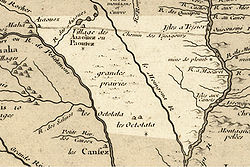
word meaning "river of the mounds" in reference to the burial mounds that were located near the banks of the river. The 1718 Guillaume Delisle
Guillaume Delisle
Guillaume Delisle was a French cartographer who lived in Paris.His father, Claude Delisle studied law and then later settled in Paris as private teacher in geography and history, and afterwards filled the office of royal censor...
map (pictured) labels it "le Moingona R."
It is also claimed that the name "des Moines" is the result of a hoax
Hoax
A hoax is a deliberately fabricated falsehood made to masquerade as truth. It is distinguishable from errors in observation or judgment, or rumors, urban legends, pseudosciences or April Fools' Day events that are passed along in good faith by believers or as jokes.-Definition:The British...
. In 1673 Father Jacques Marquette
Jacques Marquette
Father Jacques Marquette S.J. , sometimes known as Père Marquette, was a French Jesuit missionary who founded Michigan's first European settlement, Sault Ste. Marie, and later founded St. Ignace, Michigan...
met some representatives of the Peoria
Peoria (tribe)
The Peoria people are a Native American tribe. Today they are enrolled in the federally recognized Peoria Tribe of Indians of Oklahoma. Historically, they were part of the Illinois Confederation.-History:...
tribe near the mouth of the modern-day Des Moines River. He asked them the name of the rival tribe that lived further along the banks of the river. The Peoria told him that tribe was called the Moingoana, which became the root for the word 'Moines'. But researcher Michael McCafferty of Indiana University
Indiana University
Indiana University is a multi-campus public university system in the state of Indiana, United States. Indiana University has a combined student body of more than 100,000 students, including approximately 42,000 students enrolled at the Indiana University Bloomington campus and approximately 37,000...
, while studying the now extinct Miami-Illinois language, discovered that Moingoana, translated literally, meant "shit faces".http://www.museumofhoaxes.com/hoax/weblog/permalink/the_true_meaning_of_des_moines/
During the mid-19th century, the river provided the main commercial transportation across Iowa until the building of the railroads in the 1860s.
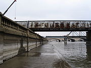
Flooding
The Great Flood of 1993
Great Flood of 1993
The Great Mississippi and Missouri Rivers Flood of 1993 occurred in the American Midwest, along the Mississippi and Missouri rivers and their tributaries, from April to October 1993. The flood was among the most costly and devastating to ever occur in the United States, with $15 billion in damages...
on the river and its tributary the Raccoon in the summer of 1993 forced the evacuation of much of the city of Des Moines and nearby communities. On June 13, 2008, officials issued a voluntary evacuation order for much of downtown and other areas bordering the Des Moines River. The river had reached flood stage in many locations, and Mayor Frank Cownie said the evacuations were an attempt "to err on the side of citizens and residents."
Cities and towns
- Algona, IowaAlgona, IowaAlgona is a city in and the county seat of Kossuth County, Iowa, United States. The population was 5,741 at the 2000 census. Ambrose A. Call State Park is located two miles southwest of the city.-History:...
(East Fork) - Armstrong, IowaArmstrong, IowaArmstrong is a city in Emmet County, Iowa, United States. The population was 979 at the 2000 census. It was originally known as Armstrong Grove.-Geography:Armstrong is located at ....
(East Fork) - Bonaparte, IowaBonaparte, IowaBonaparte is a city in Van Buren County, Iowa, United States. The population was 458 at the 2000 census. The town is located on the Des Moines River and contains a number of historical buildings, including a large pottery. The town was flooded during the Flood of 1851.-Geography:Bonaparte's...
- Bradgate, IowaBradgate, Iowa-2010 census:The 2010 census recorded a population of 86 in Bradgate, with a population density of .-2000 census:As of the census of 2000, there were 101 people, 48 households, and 30 families residing in the town. The population density was 291.1 people per square mile . There were 54 housing...
(West Fork) - Chillicothe, IowaChillicothe, IowaChillicothe is a city in Wapello County, Iowa, United States. The population was 90 at the 2000 census.-History:The word "Chillicothe" is derived from the ancient Shawnee Indian words meaning "Principal Place." It was the name for one of their clans. The main chief of the Shawnee could only come...
- Currie, MinnesotaCurrie, MinnesotaAs of the census of 2000, there were 225 people, 109 households, and 67 families residing in the city. The population density was 393.0 people per square mile . There were 127 housing units at an average density of 221.9 per square mile . The racial makeup of the city was 99.56% White, and 0.44%...
- Dakota City, IowaDakota City, IowaDakota City is a city in and the county seat of Humboldt County, Iowa, United States. The population was 911 at the 2000 census. Dakota City shares its western border with the much larger city of Humboldt.-Geography:...
(East Fork) - Des Moines, IowaDes Moines, IowaDes Moines is the capital and the most populous city in the US state of Iowa. It is also the county seat of Polk County. A small portion of the city extends into Warren County. It was incorporated on September 22, 1851, as Fort Des Moines which was shortened to "Des Moines" in 1857...
- Douds, IowaDouds, IowaDouds is a census-designated place in Van Buren County, Iowa, United States. The population was 165 at the 2000 census.-History:Douds was platted in the 1860s by brothers Eliab and David Doud. Douds was never officially incorporated as a town, but has a Post Office and its own zip code. On the...
- Eddyville, IowaEddyville, IowaEddyville is a city in Mahaska, Monroe, and Wapello Counties in the U.S. state of Iowa. The population was 1,024 at the 2010 census.-History:...
- Eldon, IowaEldon, IowaEldon is a city in Wapello County, Iowa, United States. The population was 998 at the 2000 census. Eldon is the site of the small Carpenter Gothic style house that has come to be known as the American Gothic House because Grant Wood used it for the background in his famous 1930 painting American...
- Estherville, IowaEstherville, IowaEstherville is a city in Emmet County, Iowa, United States. The population was 6,360 in the 2010 census, a decline from 6,656 in the 2000 census. It is the county seat of Emmet County. Estherville is home to the main campus of Iowa Lakes Community College...
(West Fork) - Farmington, IowaFarmington, IowaFarmington is a city in Van Buren County, Iowa, United States. The population was 756 at the 2000 census.-Geography:Farmington is located at , on the east bank of Des Moines River....
- Fort Dodge, IowaFort Dodge, IowaFort Dodge is a city and county seat of Webster County, Iowa, United States, along the Des Moines River. The population was 25,206 in the 2010 census, an increase from 25,136 in the 2000 census. Fort Dodge is a major commercial center for North Central and Northwest Iowa. It is located on U.S...
- Fraser, IowaFraser, IowaFraser is a city in Dodge Township, Boone County, Iowa, United States. The population was 137 at the 2000 census. It is part of the 'Boone, Iowa Micropolitan Statistical Area', which is a part of the larger 'Ames-Boone, Iowa Combined Statistical Area'...
- Graettinger, IowaGraettinger, IowaGraettinger is a city in Palo Alto County, Iowa, United States. The population was 900 at the 2000 census.-History:The city was built by German settlers who came first to Graettinger....
(West Fork) - Humboldt, IowaHumboldt, IowaHumboldt is a city in Humboldt County, Iowa, United States. The population was 4,690 at the 2010 census, gaining 238 people since the 2000 census.- History :...
(West Fork) - Irvington, Iowa (East Fork)
- Jackson, MinnesotaJackson, MinnesotaJackson is a city in Jackson County, Minnesota, United States. The population was 3,299 at the 2010 census. It is the county seat of Jackson County.-Geography:...
- Johnston, IowaJohnston, Iowa-2010 census:The 2010 census recorded a population of 17,278 in the city, with a population density of . There were 6,618 housing units, of which 6,369 were occupied....
- Keokuk, IowaKeokuk, IowaKeokuk is a city in the southeastern part of the U.S. state of Iowa and one of the county seats of Lee County. The other county seat is Fort Madison. The population was 11,427 at the 2000 census. The city is named after the Sauk Chief Keokuk, who is thought to be buried in Rand Park...
- Keosauqua, IowaKeosauqua, IowaKeosauqua is a city in Van Buren County, Iowa, United States. The population was 1,066 at the 2000 census. It is the county seat of Van Buren County.-History:...
- Leando, IowaLeando, IowaLeando is a census-designated place in Van Buren County, Iowa, United States. The population was 135 at the 2000 census.-Geography:Leando is located at ....
- Lehigh, IowaLehigh, IowaLehigh is a city in Webster County, Iowa, United States. The population was 497 at the 2000 census.Located in a valley, Lehigh is divided in two by the Des Moines River, unusual for such a small town. Originally the two halves of Lehigh were two separate towns...
- Livermore, IowaLivermore, IowaLivermore is a city in Humboldt County, Iowa, United States. The population was 431 at the 2000 census. Livermore is the hometown of Indianapolis Colts tight end Dallas Clark.-History:...
(East Fork) - Ottumwa, IowaOttumwa, IowaOttumwa is a city in and the county seat of Wapello County, Iowa, United States. The population was 24,998 at the 2000 census. It is located in the southeastern part of Iowa, and the city is split into northern and southern halves by the Des Moines River....
- Petersburg, Minnesota (West Fork)
- Rutland, IowaRutland, IowaRutland is a city in Humboldt County, Iowa, United States. The population was 145 at the 2000 census.-Geography:Rutland is located at on the West Fork Des Moines River....
(West Fork) - St. Joseph, Iowa (East Fork)
- Windom, MinnesotaWindom, MinnesotaAs of the census of 2000, there were 4,490 people, 1,910 households, and 1,195 families residing in the city. The population density was 1,263.6 people per square mile . There were 2,089 housing units at an average density of 587.9 per square mile...
Variant names
According to the Geographic Names Information SystemGeographic Names Information System
The Geographic Names Information System is a database that contains name and locative information about more than two million physical and cultural features located throughout the United States of America and its territories. It is a type of gazetteer...
, the Des Moines River has also been known as:
- La Riviere des Moins
- Le Moine River
- Monk River
- Nadouessioux River
- Outontantes River
- River Demoin
- River of the Maskoutens
- River of the Peouareas
See also
- List of Iowa rivers
- List of longest rivers of the United States (by main stem)
- List of Minnesota rivers
- List of Missouri rivers
- Illinois CountryIllinois CountryThe Illinois Country , also known as Upper Louisiana, was a region in what is now the Midwestern United States that was explored and settled by the French during the 17th and 18th centuries. The terms referred to the entire Upper Mississippi River watershed, though settlement was concentrated in...
- French colonization of the AmericasFrench colonization of the AmericasThe French colonization of the Americas began in the 16th century, and continued in the following centuries as France established a colonial empire in the Western Hemisphere. France founded colonies in much of eastern North America, on a number of Caribbean islands, and in South America...