

Polk County, Iowa
Encyclopedia
Polk County is a county
located in the U.S. state
of Iowa
. The population was 430,640 in the 2010 census, an increase from 374,601 in the 2000 census. The county seat
is Des Moines
, which is also the capital city of Iowa. Polk County is one of the five counties that make up the Des Moines–West Des Moines
Metropolitan Statistical Area
.
.
The first courthouse, a two-story structure, was built in 1846. Construction of a second courthouse was begun in 1858. Due to construction delays and the onset of the Civil War, the structure was not completed until 1866. The present courthouse
was erected in 1906 in the Beaux Arts style. It was dedicated on October 31, 1906. In 1962, an extensive renovation was undertaken.
is located in Mitchellville
and in Polk County.
 As of the census
of 2000, there were 374,601 people, 149,112 households, and 96,624 families residing in the county. The population density
was 658 people per square mile (254/km²). There were 156,447 housing units at an average density of 275 per square mile (106/km²). The racial makeup of the county was 88.34% White
, 4.84% Black
or African American
, 0.27% Native American
, 2.63% Asian
, 0.06% Pacific Islander
, 2.22% from other races
, and 1.66% from two or more races. 4.40% of the population were Hispanic
or Latino
of any race. 25.9% were of German
, 10.6% Irish
, 9.0% English
and 8.4% American
ancestry according to Census 2000.
There were 149,112 households out of which 32.20% had children under the age of 18 living with them, 51.00% were married couples
living together, 10.30% had a female householder with no husband present, and 35.20% were non-families. 28.10% of all households were made up of individuals and 8.60% had someone living alone who was 65 years of age or older. The average household size was 2.45 and the average family size was 3.04.
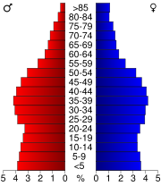
In the county the population was spread out with 25.70% under the age of 18, 9.40% from 18 to 24, 32.20% from 25 to 44, 21.50% from 45 to 64, and 11.10% who were 65 years of age or older. The median age was 34 years. For every 100 females there were 94.20 males. For every 100 females age 18 and over, there were 90.70 males.
The median income for a household in the county was $46,116, and the median income for a family was $56,560. Males had a median income of $37,182 versus $28,000 for females. The per capita income
for the county was $23,654. About 5.30% of families and 7.90% of the population were below the poverty line, including 9.70% of those under age 18 and 6.40% of those age 65 or over.
County (United States)
In the United States, a county is a geographic subdivision of a state , usually assigned some governmental authority. The term "county" is used in 48 of the 50 states; Louisiana is divided into parishes and Alaska into boroughs. Parishes and boroughs are called "county-equivalents" by the U.S...
located in the U.S. state
U.S. state
A U.S. state is any one of the 50 federated states of the United States of America that share sovereignty with the federal government. Because of this shared sovereignty, an American is a citizen both of the federal entity and of his or her state of domicile. Four states use the official title of...
of Iowa
Iowa
Iowa is a state located in the Midwestern United States, an area often referred to as the "American Heartland". It derives its name from the Ioway people, one of the many American Indian tribes that occupied the state at the time of European exploration. Iowa was a part of the French colony of New...
. The population was 430,640 in the 2010 census, an increase from 374,601 in the 2000 census. The county seat
County seat
A county seat is an administrative center, or seat of government, for a county or civil parish. The term is primarily used in the United States....
is Des Moines
Des Moines, Iowa
Des Moines is the capital and the most populous city in the US state of Iowa. It is also the county seat of Polk County. A small portion of the city extends into Warren County. It was incorporated on September 22, 1851, as Fort Des Moines which was shortened to "Des Moines" in 1857...
, which is also the capital city of Iowa. Polk County is one of the five counties that make up the Des Moines–West Des Moines
West Des Moines, Iowa
West Des Moines is a city in Polk, Dallas, and Warren counties in the U.S. state of Iowa. As of the 2000 census, the city population was 46,403; a special census taken in the spring of 2005 counted 51,744 residents and the United States Census Bureau estimated that 53,889 residents lived there in...
Metropolitan Statistical Area
Des Moines metropolitan area
The Des Moines metropolitan area, officially known as the Des Moines-West Des Moines Metropolitan Statistical Area , consists of five counties in central Iowa, United States: Polk, Dallas, Warren, Madison, and Guthrie...
.
History
Polk County was formed on January 13, 1846. It was named after President James K. PolkJames K. Polk
James Knox Polk was the 11th President of the United States . Polk was born in Mecklenburg County, North Carolina. He later lived in and represented Tennessee. A Democrat, Polk served as the 17th Speaker of the House of Representatives and the 12th Governor of Tennessee...
.
The first courthouse, a two-story structure, was built in 1846. Construction of a second courthouse was begun in 1858. Due to construction delays and the onset of the Civil War, the structure was not completed until 1866. The present courthouse
Polk County Courthouse (Iowa)
The Polk County Courthouse in Des Moines, Iowa, United States was built in 1906. It was listed on the National Register of Historic Places in 1979 as a part of the County Courthouses in Iowa Thematic Resource. The courthouse is the third building the county has used for court functions and county...
was erected in 1906 in the Beaux Arts style. It was dedicated on October 31, 1906. In 1962, an extensive renovation was undertaken.
Geography
According to the 2000 census, the county has a total area of 591.9 square miles (1,533 km²), of which 569.35 square miles (1,474.6 km²) (or 96.19%) is land and 22.55 square miles (58.4 km²) (or 3.81%) is water. The county is bisected by the Des Moines RiverDes Moines River
The Des Moines River is a tributary river of the Mississippi River, approximately long to its farther headwaters, in the upper Midwestern United States...
Major highways
|
|
.svg.png)
.svg.png)
.svg.png)
 U.S. Highway 6
 U.S. Highway 65
 U.S. Highway 69
 Iowa Highway 5
 Iowa Highway 17
 Iowa Highway 28

 Iowa Highway 163
Adjacent counties
- Boone CountyBoone County, Iowa-2010 census:The 2010 census recorded a population of 26,306 in the county, with a population density of . There were 11,756 housing units, of which 10,728 were occupied.-2000 census:...
(northwest) - Story CountyStory County, Iowa-2010 census:The 2010 census recorded a population of 89,542 in the county, with a population density of . There were 36,789 housing units, of which 34,736 were occupied.-2000 census:...
(north) - Jasper CountyJasper County, Iowa-2010 census:The 2010 census recorded a population of 36,842 in the county, with a population density of . There were 16,181 housing units, of which 14,806 were occupied.-2000 census:...
(east) - Marion CountyMarion County, Iowa-2010 census:The 2010 census recorded a population of 33,309 in the county, with a population density of . There were 13,914 housing units, of which 12,723 were occupied.-2000 census:...
(southeast) - Warren County (south)
- Madison CountyMadison County, Iowa-2010 census:The 2010 census recorded a population of 15,679 in the county, with a population density of . There were 6,554 housing units, of which 6,025 were occupied.-2000 census:...
(southwest) - Dallas CountyDallas County, Iowa-2010 census:The 2010 census recorded a population of 66,135 in the county, with a population density of . There were 27,260 housing units, of which 25,240 were occupied.-2000 census:...
(west)
Economy
The Iowa Department of Corrections Iowa Correctional Institution for WomenIowa Correctional Institution for Women
Iowa Correctional Institution for Women is an Iowa Department of Corrections medium/minimum security prison located in Mitchellville, Iowa. As of 2002 it had some 190 staff and 510 inmates....
is located in Mitchellville
Mitchellville, Iowa
Mitchellville is a city in Polk and Jasper counties in the U.S. state of Iowa. The population was 1,715 at the 2000 census.The Polk County portion of Mitchellville is part of the Des Moines–West Des Moines Metropolitan Statistical Area, while the Jasper County portion is part of the Newton...
and in Polk County.
Demographics
2010 census
The 2010 census recorded a population of 430,640 in the county, with a population density of . There were 182,262 housing units, of which 170,197 were occupied.2000 census
Census
A census is the procedure of systematically acquiring and recording information about the members of a given population. It is a regularly occurring and official count of a particular population. The term is used mostly in connection with national population and housing censuses; other common...
of 2000, there were 374,601 people, 149,112 households, and 96,624 families residing in the county. The population density
Population density
Population density is a measurement of population per unit area or unit volume. It is frequently applied to living organisms, and particularly to humans...
was 658 people per square mile (254/km²). There were 156,447 housing units at an average density of 275 per square mile (106/km²). The racial makeup of the county was 88.34% White
Race (United States Census)
Race and ethnicity in the United States Census, as defined by the Federal Office of Management and Budget and the United States Census Bureau, are self-identification data items in which residents choose the race or races with which they most closely identify, and indicate whether or not they are...
, 4.84% Black
Race (United States Census)
Race and ethnicity in the United States Census, as defined by the Federal Office of Management and Budget and the United States Census Bureau, are self-identification data items in which residents choose the race or races with which they most closely identify, and indicate whether or not they are...
or African American
Race (United States Census)
Race and ethnicity in the United States Census, as defined by the Federal Office of Management and Budget and the United States Census Bureau, are self-identification data items in which residents choose the race or races with which they most closely identify, and indicate whether or not they are...
, 0.27% Native American
Race (United States Census)
Race and ethnicity in the United States Census, as defined by the Federal Office of Management and Budget and the United States Census Bureau, are self-identification data items in which residents choose the race or races with which they most closely identify, and indicate whether or not they are...
, 2.63% Asian
Race (United States Census)
Race and ethnicity in the United States Census, as defined by the Federal Office of Management and Budget and the United States Census Bureau, are self-identification data items in which residents choose the race or races with which they most closely identify, and indicate whether or not they are...
, 0.06% Pacific Islander
Race (United States Census)
Race and ethnicity in the United States Census, as defined by the Federal Office of Management and Budget and the United States Census Bureau, are self-identification data items in which residents choose the race or races with which they most closely identify, and indicate whether or not they are...
, 2.22% from other races
Race (United States Census)
Race and ethnicity in the United States Census, as defined by the Federal Office of Management and Budget and the United States Census Bureau, are self-identification data items in which residents choose the race or races with which they most closely identify, and indicate whether or not they are...
, and 1.66% from two or more races. 4.40% of the population were Hispanic
Race (United States Census)
Race and ethnicity in the United States Census, as defined by the Federal Office of Management and Budget and the United States Census Bureau, are self-identification data items in which residents choose the race or races with which they most closely identify, and indicate whether or not they are...
or Latino
Race (United States Census)
Race and ethnicity in the United States Census, as defined by the Federal Office of Management and Budget and the United States Census Bureau, are self-identification data items in which residents choose the race or races with which they most closely identify, and indicate whether or not they are...
of any race. 25.9% were of German
Germans
The Germans are a Germanic ethnic group native to Central Europe. The English term Germans has referred to the German-speaking population of the Holy Roman Empire since the Late Middle Ages....
, 10.6% Irish
Irish people
The Irish people are an ethnic group who originate in Ireland, an island in northwestern Europe. Ireland has been populated for around 9,000 years , with the Irish people's earliest ancestors recorded having legends of being descended from groups such as the Nemedians, Fomorians, Fir Bolg, Tuatha...
, 9.0% English
English people
The English are a nation and ethnic group native to England, who speak English. The English identity is of early mediaeval origin, when they were known in Old English as the Anglecynn. England is now a country of the United Kingdom, and the majority of English people in England are British Citizens...
and 8.4% American
United States
The United States of America is a federal constitutional republic comprising fifty states and a federal district...
ancestry according to Census 2000.
There were 149,112 households out of which 32.20% had children under the age of 18 living with them, 51.00% were married couples
Marriage
Marriage is a social union or legal contract between people that creates kinship. It is an institution in which interpersonal relationships, usually intimate and sexual, are acknowledged in a variety of ways, depending on the culture or subculture in which it is found...
living together, 10.30% had a female householder with no husband present, and 35.20% were non-families. 28.10% of all households were made up of individuals and 8.60% had someone living alone who was 65 years of age or older. The average household size was 2.45 and the average family size was 3.04.
In the county the population was spread out with 25.70% under the age of 18, 9.40% from 18 to 24, 32.20% from 25 to 44, 21.50% from 45 to 64, and 11.10% who were 65 years of age or older. The median age was 34 years. For every 100 females there were 94.20 males. For every 100 females age 18 and over, there were 90.70 males.
The median income for a household in the county was $46,116, and the median income for a family was $56,560. Males had a median income of $37,182 versus $28,000 for females. The per capita income
Per capita income
Per capita income or income per person is a measure of mean income within an economic aggregate, such as a country or city. It is calculated by taking a measure of all sources of income in the aggregate and dividing it by the total population...
for the county was $23,654. About 5.30% of families and 7.90% of the population were below the poverty line, including 9.70% of those under age 18 and 6.40% of those age 65 or over.
Cities
|
Clive, Iowa Clive is a city in Dallas and Polk counties in the U.S. state of Iowa. As of the 2010 Census the population is at 15,447. It is part of the Des Moines–West Des Moines Metropolitan Statistical Area. Clive is known for its outstanding Greenbelt Park and trail system running through the entire... Des Moines, Iowa Des Moines is the capital and the most populous city in the US state of Iowa. It is also the county seat of Polk County. A small portion of the city extends into Warren County. It was incorporated on September 22, 1851, as Fort Des Moines which was shortened to "Des Moines" in 1857... Elkhart, Iowa Elkhart is a city in Polk County, Iowa, United States. The population was 362 at the 2000 census. It is part of the Des Moines–West Des Moines Metropolitan Statistical Area.-History:Elkhart was founded in 1853 by settlers from Elkhart, Indiana... Granger, Iowa As of the census of 2000, there were 583 people, 245 households, and 150 families residing in the city. The population density was 1,136.6 people per square mile . There were 265 housing units at an average density of 516.6 per square mile . The racial makeup of the city was 98.63% White, 0.17%... Grimes, Iowa As of the census of 2000, there were 5,098 people, 1,887 households, and 1,437 families residing in the city. The population density was 569.4 people per square mile . There were 1,958 housing units at an average density of 218.7 per square mile... |
Johnston, Iowa -2010 census:The 2010 census recorded a population of 17,278 in the city, with a population density of . There were 6,618 housing units, of which 6,369 were occupied.... Mitchellville, Iowa Mitchellville is a city in Polk and Jasper counties in the U.S. state of Iowa. The population was 1,715 at the 2000 census.The Polk County portion of Mitchellville is part of the Des Moines–West Des Moines Metropolitan Statistical Area, while the Jasper County portion is part of the Newton... Norwalk, Iowa Norwalk is a city in Polk and Warren counties in the U.S. state of Iowa. The population was 6,884 at the 2000 census. The city is part of the Des Moines–West Des Moines Metropolitan Statistical Area and is located just south of the Des Moines International Airport.-History:The first log cabin... Pleasant Hill, Iowa Pleasant Hill is a city in Polk County, Iowa, United States. The population was 5,070 at the 2000 census. It is part of the Des Moines–West Des Moines Metropolitan Statistical Area. The waterpark White Water University is located in Pleasant Hill, as is part of Festival Park... Polk City, Iowa As of the census of 2000, there were 2,344 people, 826 households, and 645 families residing in the city. The population density was 862.4 people per square mile . There were 842 housing units at an average density of 309.8 per square mile... |
Runnells, Iowa Runnells is a city in Polk County, Iowa, United States. The population was 352 at the 2000 census. It is part of the Des Moines–West Des Moines Metropolitan Statistical Area.-History:... Sheldahl, Iowa Sheldahl is a city in Polk, and Story counties in the U.S. state of Iowa. The population was 336 at the 2000 census.The Boone County portion of Sheldahl is part of the Boone Micropolitan Statistical Area, while the Story County portion is part of the Ames Metropolitan Statistical Area. Together,... Urbandale, Iowa Urbandale is a city in Polk and Dallas counties in the U.S. state of Iowa. As of the 2000 census, the city population was 29,072; a special census taken by the city in 2005 counted 35,904 residents and the United States Census Bureau estimated that 38,369 residents lived there in 2008... West Des Moines, Iowa West Des Moines is a city in Polk, Dallas, and Warren counties in the U.S. state of Iowa. As of the 2000 census, the city population was 46,403; a special census taken in the spring of 2005 counted 51,744 residents and the United States Census Bureau estimated that 53,889 residents lived there in... Windsor Heights, Iowa Windsor Heights is a city in Polk County, Iowa, United States. The population was 4,805 at the 2000 census. It is part of the Des Moines–West Des Moines Metropolitan Statistical Area.-History:Windsor Heights incorporated as a city on July 19, 1941... |
Unincorporated communities
|
Farrar, Iowa Farrar is an unincorporated community in Polk County, Iowa, United States. An unused elementary school building and one church are located in Farrar and 13 houses.-External links:*... |
Saylorville, Iowa Saylorville is a census-designated place in Polk County, Iowa, United States. The population was 3,238 at the 2000 census. It is part of the Des Moines–West Des Moines Metropolitan Statistical Area. The Saydel Community School District is located in this area... (CDP Census-designated place A census-designated place is a concentration of population identified by the United States Census Bureau for statistical purposes. CDPs are delineated for each decennial census as the statistical counterparts of incorporated places such as cities, towns and villages... ) |
See also
- Polk County CourthousePolk County Courthouse (Iowa)The Polk County Courthouse in Des Moines, Iowa, United States was built in 1906. It was listed on the National Register of Historic Places in 1979 as a part of the County Courthouses in Iowa Thematic Resource. The courthouse is the third building the county has used for court functions and county...
- Iowa State CapitolIowa State CapitolThe Iowa State Capitol is located in Iowa's capital city, Des Moines, and houses the Iowa Senate, Iowa House of Representatives, the Office of the Governor, and the Offices of the Attorney General, Auditor, Treasurer, and Secretary of State...
- Terrace HillTerrace HillTerrace Hill, also known as Hubbell Mansion, Benjamin F. Allen House, and Iowa Governor's Mansion, is the official residence of the Governor of Iowa. Located in Des Moines, Iowa, it is an example of Second Empire architecture. The home measures 18,000 square feet...
also known as Hubbell Mansion, Benjamin F. Allen House, or the Iowa Governor's Mansion. - National Register of Historic Places listings in Polk County, IowaNational Register of Historic Places listings in Polk County, IowaThis is a list of the National Register of Historic Places listings in Polk County, Iowa.This is intended to be a complete list of the properties and districts on the National Register of Historic Places in Polk County, Iowa, United States...