

Green County, Wisconsin
Encyclopedia
Green County is a county
located in the U.S. state
of Wisconsin
. As of 2000, the population was 33,647. Its county seat
is Monroe
.
, the county has a total area of 585 square miles (1,515.1 km²), of which 584 square miles (1,512.6 km²) is land and 1 square miles (2.6 km²) (0.10%) is water.
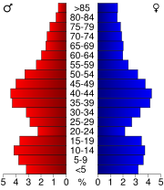
As of the census
of 2000, there were 33,647 people, 13,212 households, and 9,208 families residing in the county. The population density
was 58 people per square mile (22/km²). There were 13,878 housing units at an average density of 24 per square mile (9/km²). The racial makeup of the county was 98.14% White
, 0.26% Black
or African American
, 0.21% Native American
, 0.29% Asian
, 0.36% from other races
, and 0.75% from two or more races. 0.97% of the population were Hispanic
or Latino
of any race. 31.9% were of German, 20.3% Swiss, 14.9% Norwegian, 6.7% Irish
, 5.7% English
and 5.5% American
ancestry according to Census 2000. 96.5% spoke English
, 2.0% German
and 1.1% Spanish
as their first language.
There were 13,212 households out of which 33.70% had children under the age of 18 living with them, 58.30% were married couples
living together, 7.50% had a female householder with no husband present, and 30.30% were non-families. 25.00% of all households were made up of individuals and 11.20% had someone living alone who was 65 years of age or older. The average household size was 2.51 and the average family size was 3.01.
In the county, the population was spread out with 26.50% under the age of 18, 6.70% from 18 to 24, 29.20% from 25 to 44, 22.90% from 45 to 64, and 14.70% who were 65 years of age or older. The median age was 38 years. For every 100 females there were 96.90 males. For every 100 females age 18 and over, there were 94.20 males.
County (United States)
In the United States, a county is a geographic subdivision of a state , usually assigned some governmental authority. The term "county" is used in 48 of the 50 states; Louisiana is divided into parishes and Alaska into boroughs. Parishes and boroughs are called "county-equivalents" by the U.S...
located in the U.S. state
U.S. state
A U.S. state is any one of the 50 federated states of the United States of America that share sovereignty with the federal government. Because of this shared sovereignty, an American is a citizen both of the federal entity and of his or her state of domicile. Four states use the official title of...
of Wisconsin
Wisconsin
Wisconsin is a U.S. state located in the north-central United States and is part of the Midwest. It is bordered by Minnesota to the west, Iowa to the southwest, Illinois to the south, Lake Michigan to the east, Michigan to the northeast, and Lake Superior to the north. Wisconsin's capital is...
. As of 2000, the population was 33,647. Its county seat
County seat
A county seat is an administrative center, or seat of government, for a county or civil parish. The term is primarily used in the United States....
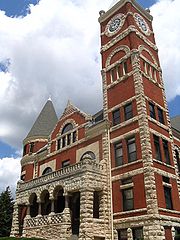
is Monroe
Monroe, Wisconsin
Monroe, known as "the Swiss Cheese Capital of the USA", is a city in and the county seat of Green County, Wisconsin, United States. The population, was 10,843 at the 2000 census. The city is located partially within the Town of Monroe and partially in the Town of Clarno.-Geography:Monroe is located...
.
Geography
According to the U.S. Census BureauUnited States Census Bureau
The United States Census Bureau is the government agency that is responsible for the United States Census. It also gathers other national demographic and economic data...
, the county has a total area of 585 square miles (1,515.1 km²), of which 584 square miles (1,512.6 km²) is land and 1 square miles (2.6 km²) (0.10%) is water.
Major highways


Adjacent counties
- Dane County, WisconsinDane County, WisconsinAs of the census of 2000, there were 426,526 people, 173,484 households, and 100,794 families residing in the county. The population density was 355 people per square mile . There were 180,398 housing units at an average density of 150 per square mile...
- north - Rock County, WisconsinRock County, Wisconsin-Unincorporated communities:-Further reading:* . Chicago: Western Historical Company, 1879.* Brown, William F. , Chicago: Cooper, 1908.* Brown, William F. , Chicago: Cooper, 1908....
- east - Winnebago County, IllinoisWinnebago County, IllinoisWinnebago County is a county located in the U.S. state of Illinois. According to the 2010 census, it has a population of 295,266, which is an increase of 6.1% from 278,418 in 2000...
- southeast - Stephenson County, IllinoisStephenson County, IllinoisAs of the census of 2000, there were 48,979 people, 19,785 households, and 13,473 families residing in the county. The population density was 87 people per square mile . There were 21,713 housing units at an average density of 38 per square mile...
- south - Lafayette County, WisconsinLafayette County, WisconsinLafayette County is a county located in the U.S. state of Wisconsin. As of 2000, the population was 16,137. Its county seat is Darlington.-Geography:According to the U.S...
- west - Iowa County, WisconsinIowa County, WisconsinIowa County is a county located in the U.S. state of Wisconsin. As of 2000, the population was 22,780. Its county seat and largest city is Dodgeville.Iowa County is part of the Madison Metropolitan Statistical Area.-Geography:According to the U.S...
- northwest
Demographics
As of the census
Census
A census is the procedure of systematically acquiring and recording information about the members of a given population. It is a regularly occurring and official count of a particular population. The term is used mostly in connection with national population and housing censuses; other common...
of 2000, there were 33,647 people, 13,212 households, and 9,208 families residing in the county. The population density
Population density
Population density is a measurement of population per unit area or unit volume. It is frequently applied to living organisms, and particularly to humans...
was 58 people per square mile (22/km²). There were 13,878 housing units at an average density of 24 per square mile (9/km²). The racial makeup of the county was 98.14% White
Race (United States Census)
Race and ethnicity in the United States Census, as defined by the Federal Office of Management and Budget and the United States Census Bureau, are self-identification data items in which residents choose the race or races with which they most closely identify, and indicate whether or not they are...
, 0.26% Black
Race (United States Census)
Race and ethnicity in the United States Census, as defined by the Federal Office of Management and Budget and the United States Census Bureau, are self-identification data items in which residents choose the race or races with which they most closely identify, and indicate whether or not they are...
or African American
Race (United States Census)
Race and ethnicity in the United States Census, as defined by the Federal Office of Management and Budget and the United States Census Bureau, are self-identification data items in which residents choose the race or races with which they most closely identify, and indicate whether or not they are...
, 0.21% Native American
Race (United States Census)
Race and ethnicity in the United States Census, as defined by the Federal Office of Management and Budget and the United States Census Bureau, are self-identification data items in which residents choose the race or races with which they most closely identify, and indicate whether or not they are...
, 0.29% Asian
Race (United States Census)
Race and ethnicity in the United States Census, as defined by the Federal Office of Management and Budget and the United States Census Bureau, are self-identification data items in which residents choose the race or races with which they most closely identify, and indicate whether or not they are...
, 0.36% from other races
Race (United States Census)
Race and ethnicity in the United States Census, as defined by the Federal Office of Management and Budget and the United States Census Bureau, are self-identification data items in which residents choose the race or races with which they most closely identify, and indicate whether or not they are...
, and 0.75% from two or more races. 0.97% of the population were Hispanic
Race (United States Census)
Race and ethnicity in the United States Census, as defined by the Federal Office of Management and Budget and the United States Census Bureau, are self-identification data items in which residents choose the race or races with which they most closely identify, and indicate whether or not they are...
or Latino
Race (United States Census)
Race and ethnicity in the United States Census, as defined by the Federal Office of Management and Budget and the United States Census Bureau, are self-identification data items in which residents choose the race or races with which they most closely identify, and indicate whether or not they are...
of any race. 31.9% were of German, 20.3% Swiss, 14.9% Norwegian, 6.7% Irish
Irish people
The Irish people are an ethnic group who originate in Ireland, an island in northwestern Europe. Ireland has been populated for around 9,000 years , with the Irish people's earliest ancestors recorded having legends of being descended from groups such as the Nemedians, Fomorians, Fir Bolg, Tuatha...
, 5.7% English
English people
The English are a nation and ethnic group native to England, who speak English. The English identity is of early mediaeval origin, when they were known in Old English as the Anglecynn. England is now a country of the United Kingdom, and the majority of English people in England are British Citizens...
and 5.5% American
United States
The United States of America is a federal constitutional republic comprising fifty states and a federal district...
ancestry according to Census 2000. 96.5% spoke English
English language
English is a West Germanic language that arose in the Anglo-Saxon kingdoms of England and spread into what was to become south-east Scotland under the influence of the Anglian medieval kingdom of Northumbria...
, 2.0% German
German language
German is a West Germanic language, related to and classified alongside English and Dutch. With an estimated 90 – 98 million native speakers, German is one of the world's major languages and is the most widely-spoken first language in the European Union....
and 1.1% Spanish
Spanish language
Spanish , also known as Castilian , is a Romance language in the Ibero-Romance group that evolved from several languages and dialects in central-northern Iberia around the 9th century and gradually spread with the expansion of the Kingdom of Castile into central and southern Iberia during the...
as their first language.
There were 13,212 households out of which 33.70% had children under the age of 18 living with them, 58.30% were married couples
Marriage
Marriage is a social union or legal contract between people that creates kinship. It is an institution in which interpersonal relationships, usually intimate and sexual, are acknowledged in a variety of ways, depending on the culture or subculture in which it is found...
living together, 7.50% had a female householder with no husband present, and 30.30% were non-families. 25.00% of all households were made up of individuals and 11.20% had someone living alone who was 65 years of age or older. The average household size was 2.51 and the average family size was 3.01.
In the county, the population was spread out with 26.50% under the age of 18, 6.70% from 18 to 24, 29.20% from 25 to 44, 22.90% from 45 to 64, and 14.70% who were 65 years of age or older. The median age was 38 years. For every 100 females there were 96.90 males. For every 100 females age 18 and over, there were 94.20 males.
Cities, villages, and towns
Unincorporated communities
- AtticaAttica, WisconsinAttica is an unincorporated community located in the town of Brooklyn, Green County, Wisconsin, United States. Attica is located at the junction of County Highways C and X north-northwest of Albany....
- Clarence
- ClarnoClarno (community), WisconsinClarno is an unincorporated community located in the town of Clarno, Green County, Wisconsin, United States....
- DaytonDayton, Green County, WisconsinDayton is an unincorporated community located in the town of Exeter, Green County, Wisconsin, United States. Dayton is located at the junction of Wisconsin Highway 92 and County Highway D south-southeast of Belleville....
- Jordan Center
- JudaJuda, WisconsinJuda is an unincorporated census-designated place located in the town of Jefferson, in Green County, Wisconsin, United States. Juda is 5 miles east of Monroe along Wisconsin State Highway 11, and 81. As of the 2010 census, its population was 357....
- MartintownMartintown, WisconsinMartintown is an unincorporated community in the town of Cadiz, Green County, Wisconsin, United States....
- Postville
- OakleyOakley, WisconsinOakley is an unincorporated community located in the town of Spring Grove, Green County, Wisconsin, United States....
- Ross CrossingRoss Crossing, WisconsinRoss Crossing is an unincorporated community located in the town of Exeter, Green County, Wisconsin, United States. Ross Crossing is located at the junction of County Highways CC and W south-southwest of Belleville....
- SchneyvilleSchneyville, WisconsinSchneyville is an unincorporated community located in the town of Clarno, Green County, Wisconsin, United States....
- Twin GroveTwin Grove, WisconsinTwin Grove is an unincorporated community located in the town of Jefferson, Green County, Wisconsin, United States....