

Dodge County, Wisconsin
Encyclopedia
Dodge County is a county located in the U.S. state
of Wisconsin
. As of 2010, the population was 88,759. Its county seat
is Juneau.
, the county has a total area of 907 square miles (2,349.1 km²), of which 882 square miles (2,284.4 km²) is land and 25 square miles (64.7 km²) (2.72%) is water.
 As of the census
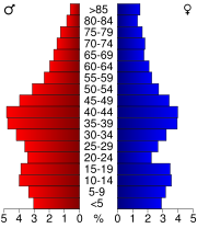
of 2000, there were 85,897 people, 31,417 households, and 22,306 families residing in the county. The population density
was 97 people per square mile (38/km²). There were 33,672 housing units at an average density of 38 per square mile (15/km²). The racial makeup of the county was 95.28% White
, 2.49% Black
or African American
, 0.40% Native American
, 0.34% Asian
, 0.03% Pacific Islander
, 0.87% from other races
, and 0.58% from two or more races. 2.55% of the population were Hispanic
or Latino
of any race. 60.9% were of German and 5.0% Irish
ancestry according to Census 2000. 95.8% spoke English
, 2.2% Spanish
and 1.5% German
as their first language. Also, in Dodge County there are some considerable African American, Arab, and Persian minorities in the western part of the county, while the east is predominately white with a small Hispanic minority .
There were 31,417 households out of which 33.90% had children under the age of 18 living with them, 59.60% were married couples
living together, 7.50% had a female householder with no husband present, and 29.00% were non-families. 24.10% of all households were made up of individuals and 10.80% had someone living alone who was 65 years of age or older. The average household size was 2.56 and the average family size was 3.05.
In the county, the population was spread out with 24.80% under the age of 18, 8.30% from 18 to 24, 31.20% from 25 to 44, 21.90% from 45 to 64, and 14.00% who were 65 years of age or older. The median age was 37 years. For every 100 females there were 109.70 males. For every 100 females age 18 and over, there were 110.80 males.
The religious demographics are actually quite diverse for rural Wisconsin. Protestants make up 50% of the county, Roman Catholics make up 31%. Muslims make up 10% of the county, and finally Jews make up 5%. Other religions make up 3%.
U.S. state
A U.S. state is any one of the 50 federated states of the United States of America that share sovereignty with the federal government. Because of this shared sovereignty, an American is a citizen both of the federal entity and of his or her state of domicile. Four states use the official title of...
of Wisconsin
Wisconsin
Wisconsin is a U.S. state located in the north-central United States and is part of the Midwest. It is bordered by Minnesota to the west, Iowa to the southwest, Illinois to the south, Lake Michigan to the east, Michigan to the northeast, and Lake Superior to the north. Wisconsin's capital is...
. As of 2010, the population was 88,759. Its county seat
County seat
A county seat is an administrative center, or seat of government, for a county or civil parish. The term is primarily used in the United States....
is Juneau.
Geography
According to the U.S. Census BureauUnited States Census Bureau
The United States Census Bureau is the government agency that is responsible for the United States Census. It also gathers other national demographic and economic data...
, the county has a total area of 907 square miles (2,349.1 km²), of which 882 square miles (2,284.4 km²) is land and 25 square miles (64.7 km²) (2.72%) is water.
Major highways
 Highway 49 (Wisconsin) Highway 49 (Wisconsin)Highway 49 (Wisconsin) State Trunk Highway 49 is a state highway in the U.S. state of Wisconsin. It runs north–south in central and southeast Wisconsin from Wittenberg to Lomira....  Highway 60 (Wisconsin) Highway 60 (Wisconsin)Highway 60 (Wisconsin) State Trunk Highway 60 is a state highway in the U.S. state of Wisconsin. It runs east–west in southern Wisconsin from the town of Grafton on Lake Michigan, to Prairie du Chien on the Mississippi River at the Iowa state line....  Highway 67 (Wisconsin) Highway 67 (Wisconsin)Highway 67 (Wisconsin) State Trunk Highway 67 is a Wisconsin state highway running from the Wisconsin/Illinois state line east of Beloit, Wisconsin north to U.S. Highway 151 east of Chilton, Wisconsin...  Highway 68 (Wisconsin) Highway 68 (Wisconsin)Highway 68 (Wisconsin) State Trunk Highway 68 is a state highway in the U.S. state of Wisconsin. It runs east–west in Dodge County from Fox Lake to Waupun.- Route description :...  Highway 19 (Wisconsin) Highway 19 (Wisconsin)Highway 19 (Wisconsin) State Trunk Highway 19 is a state highway in the U.S. state of Wisconsin. It provides a more direct route from U.S. Highway 14 near Mazomanie east to Highway 16 at Watertown, passing around the north side of Madison. WIS 19 is a local connector route that links the communities of Waunakee, Sun...  Highway 73 (Wisconsin) Highway 73 (Wisconsin)Highway 73 (Wisconsin) State Trunk Highway 73 is a state highway in the U.S. state of Wisconsin. It runs north–south across central Wisconsin from Ingram to Edgerton, with the exception of Wood and Adams counties, where this route runs east–west.-Municipalities:Highway 73 travels through Rock, Dane,...  Highway 89 (Wisconsin) Highway 89 (Wisconsin)Highway 89 (Wisconsin) State Trunk Highway 89 is a state highway in the U.S. state of Wisconsin. It runs north–south in southeast Wisconsin from near Delavan to Columbus.-References:...  Highway 175 (Wisconsin) Highway 175 (Wisconsin)Highway 175 (Wisconsin) State Trunk Highway 175 is a state highway in the U.S. state of Wisconsin. It runs north–south in central Wisconsin from in Milwaukee to just south of Fond du Lac.... |
 U.S. Highway 41
 U.S. Highway 151


Adjacent counties
- Fond du Lac CountyFond du Lac County, WisconsinFond du Lac County is a county located in the U.S. state of Wisconsin. As of 2000, the population was 97,296. Its county seat is Fond du Lac. The United States Census Bureau's Fond du Lac Metropolitan Statistical Area includes all of Fond du Lac County. The county name is French for "bottom of the...
– northeast - Washington County – east
- Waukesha CountyWaukesha County, WisconsinWaukesha County is a county in the U.S. state of Wisconsin. As of 2008, the population was 380,629. Its county seat is Waukesha.-History:The part of Wisconsin that Waukesha County now occupies was a part of Michigan when Milwaukee County was organized in September 1834. On July 4, 1836, the...
– southeast - Jefferson CountyJefferson County, WisconsinJefferson County is a county located in the U.S. state of Wisconsin. As of 2000, the population was 74,021. Its county seat is Jefferson.-Geography:According to the U.S...
– south - Dane CountyDane County, WisconsinAs of the census of 2000, there were 426,526 people, 173,484 households, and 100,794 families residing in the county. The population density was 355 people per square mile . There were 180,398 housing units at an average density of 150 per square mile...
– southwest - Columbia CountyColumbia County, Wisconsin-Unincorporated communities:*Anacker*Belle Fountain*Durwards Glen*East Friesland*Harmony Grove*Ingle*Keyeser*Lake Wisconsin*Leeds*Lowville*Marcellon*North Leeds*Okee*Otsego-External links:***...
– west - Green Lake CountyGreen Lake County, WisconsinGreen Lake County is a county located in the U.S. state of Wisconsin. As of 2000, the population was 19,105. Its county seat is Green Lake. The center of population of Wisconsin is located in Green Lake County in the city of Markesan.-Geography:...
– northwest
Demographics
Census
A census is the procedure of systematically acquiring and recording information about the members of a given population. It is a regularly occurring and official count of a particular population. The term is used mostly in connection with national population and housing censuses; other common...
of 2000, there were 85,897 people, 31,417 households, and 22,306 families residing in the county. The population density
Population density
Population density is a measurement of population per unit area or unit volume. It is frequently applied to living organisms, and particularly to humans...
was 97 people per square mile (38/km²). There were 33,672 housing units at an average density of 38 per square mile (15/km²). The racial makeup of the county was 95.28% White
Race (United States Census)
Race and ethnicity in the United States Census, as defined by the Federal Office of Management and Budget and the United States Census Bureau, are self-identification data items in which residents choose the race or races with which they most closely identify, and indicate whether or not they are...
, 2.49% Black
Race (United States Census)
Race and ethnicity in the United States Census, as defined by the Federal Office of Management and Budget and the United States Census Bureau, are self-identification data items in which residents choose the race or races with which they most closely identify, and indicate whether or not they are...
or African American
Race (United States Census)
Race and ethnicity in the United States Census, as defined by the Federal Office of Management and Budget and the United States Census Bureau, are self-identification data items in which residents choose the race or races with which they most closely identify, and indicate whether or not they are...
, 0.40% Native American
Race (United States Census)
Race and ethnicity in the United States Census, as defined by the Federal Office of Management and Budget and the United States Census Bureau, are self-identification data items in which residents choose the race or races with which they most closely identify, and indicate whether or not they are...
, 0.34% Asian
Race (United States Census)
Race and ethnicity in the United States Census, as defined by the Federal Office of Management and Budget and the United States Census Bureau, are self-identification data items in which residents choose the race or races with which they most closely identify, and indicate whether or not they are...
, 0.03% Pacific Islander
Race (United States Census)
Race and ethnicity in the United States Census, as defined by the Federal Office of Management and Budget and the United States Census Bureau, are self-identification data items in which residents choose the race or races with which they most closely identify, and indicate whether or not they are...
, 0.87% from other races
Race (United States Census)
Race and ethnicity in the United States Census, as defined by the Federal Office of Management and Budget and the United States Census Bureau, are self-identification data items in which residents choose the race or races with which they most closely identify, and indicate whether or not they are...
, and 0.58% from two or more races. 2.55% of the population were Hispanic
Race (United States Census)
Race and ethnicity in the United States Census, as defined by the Federal Office of Management and Budget and the United States Census Bureau, are self-identification data items in which residents choose the race or races with which they most closely identify, and indicate whether or not they are...
or Latino
Race (United States Census)
Race and ethnicity in the United States Census, as defined by the Federal Office of Management and Budget and the United States Census Bureau, are self-identification data items in which residents choose the race or races with which they most closely identify, and indicate whether or not they are...
of any race. 60.9% were of German and 5.0% Irish
Irish people
The Irish people are an ethnic group who originate in Ireland, an island in northwestern Europe. Ireland has been populated for around 9,000 years , with the Irish people's earliest ancestors recorded having legends of being descended from groups such as the Nemedians, Fomorians, Fir Bolg, Tuatha...
ancestry according to Census 2000. 95.8% spoke English
English language
English is a West Germanic language that arose in the Anglo-Saxon kingdoms of England and spread into what was to become south-east Scotland under the influence of the Anglian medieval kingdom of Northumbria...
, 2.2% Spanish
Spanish language
Spanish , also known as Castilian , is a Romance language in the Ibero-Romance group that evolved from several languages and dialects in central-northern Iberia around the 9th century and gradually spread with the expansion of the Kingdom of Castile into central and southern Iberia during the...
and 1.5% German
German language
German is a West Germanic language, related to and classified alongside English and Dutch. With an estimated 90 – 98 million native speakers, German is one of the world's major languages and is the most widely-spoken first language in the European Union....
as their first language. Also, in Dodge County there are some considerable African American, Arab, and Persian minorities in the western part of the county, while the east is predominately white with a small Hispanic minority .
There were 31,417 households out of which 33.90% had children under the age of 18 living with them, 59.60% were married couples
Marriage
Marriage is a social union or legal contract between people that creates kinship. It is an institution in which interpersonal relationships, usually intimate and sexual, are acknowledged in a variety of ways, depending on the culture or subculture in which it is found...
living together, 7.50% had a female householder with no husband present, and 29.00% were non-families. 24.10% of all households were made up of individuals and 10.80% had someone living alone who was 65 years of age or older. The average household size was 2.56 and the average family size was 3.05.
In the county, the population was spread out with 24.80% under the age of 18, 8.30% from 18 to 24, 31.20% from 25 to 44, 21.90% from 45 to 64, and 14.00% who were 65 years of age or older. The median age was 37 years. For every 100 females there were 109.70 males. For every 100 females age 18 and over, there were 110.80 males.
The religious demographics are actually quite diverse for rural Wisconsin. Protestants make up 50% of the county, Roman Catholics make up 31%. Muslims make up 10% of the county, and finally Jews make up 5%. Other religions make up 3%.
Cities, villages, and towns
Unincorporated communities
- AlderleyAlderley, WisconsinAlderley is an unincorporated community located in the Town of Ashippun, Dodge County, Wisconsin, United States. Alderley is located on Highway O approximately 5 miles from Stone Bank, 4 miles north of the unincorporated community of Mapleton, and 3 miles from Ashippun.-Notes:...
- Ashippun
- AsticoAstico, WisconsinAstico is an unincorporated community located in the town of Elba, Dodge County, Wisconsin, United States....
- AtwaterAtwater, WisconsinAtwater is an unincorporated community located in the town of Chester, Dodge County, Wisconsin, United States....
- Clyman JunctionClyman Junction, WisconsinClyman Junction is an unincorporated community located in the town of Clyman, Dodge County, Wisconsin, United States....
- Burnett
- East WaupunEast Waupun, WisconsinEast Waupun is an unincorporated community located in the town of Chester, Dodge County, Wisconsin, United States....
- FarmersvilleFarmersville, WisconsinFarmersville is an unincorporated community located in the town of LeRoy, Dodge County, Wisconsin, United States....
- Fox Lake JunctionFox Lake Junction, WisconsinFox Lake Junction is an unincorporated community located in the town of Fox Lake, Dodge County, Wisconsin, United States....
- HuilsburgHuilsburg, WisconsinHuilsburg is an unincorporated community located in the town of Herman, Dodge County, Wisconsin, United States....
- KnowlesKnowles, WisconsinKnowles is an unincorporated community in Dodge County, Wisconsin, United States. The community is located at the intersection of County Y and County AY, in the town of Lomira.-References:...
- LebanonLebanon (CDP), WisconsinLebanon is an unincorporated census-designated place located in the town of Lebanon, Dodge County, Wisconsin, United States. Lebanon is northeast of Watertown. Lebanon has a post office with ZIP code 53047. As of the 2010 census, its population was 204....
- LeRoyLeRoy (unincorporated community), WisconsinLeRoy is an unincorporated community in the town of LeRoy in Dodge County, Wisconsin, United States. It is located at the intersection of County Y and County YY several miles west of Knowles....
- LeipsigLeipsig, WisconsinLeipsig is an unincorporated community located in the town of Beaver Dam, Dodge County, Wisconsin, United States....
- Lyndon DaleLyndon Dale, WisconsinLyndon Dale is an unincorporated community located in the town of Fox Lake, Dodge County, Wisconsin, United States....
- Minnesota JunctionMinnesota Junction, WisconsinMinnesota Junction is an unincorporated community located, in the town of Oak Grove, in Dodge County, Wisconsin, United States. Minnesota Junction is located on Wisconsin Highway 26. It is located at latitude 43.452 and longitude -88.697 at 925 feet above mean sea level.-References:...
- NedaNeda, WisconsinNeda is an unincorporated community located in the town of Hubbard, Dodge County, Wisconsin, United States....
- Oak GroveOak Grove (community), WisconsinOak Grove is an unincorporated community located in the town of Oak Grove, Dodge County, Wisconsin, United States....
- Old AshippunOld Ashippun, WisconsinOld Ashippun is an unincorporated community located in the town of Ashippun, Dodge County, Wisconsin, United States....
- Old LebanonOld Lebanon, WisconsinOld Lebanon is an unincorporated community located in the town of Lebanon, Dodge County, Wisconsin, United States....
- PortlandPortland (community), Dodge County, WisconsinPortland is an unincorporated community located partially in the town of Portland in Dodge County, Wisconsin and partially in the town of Waterloo in Jefferson County, Wisconsin, United States....
(partial) - Rolling PrairieRolling Prairie, WisconsinRolling Prairie is an unincorporated community located between the towns of Oak Grove and Burnett in Dodge County, Wisconsin, United States.-Notes:...
- RubiconRubicon (community), WisconsinRubicon is an unincorporated community located in the town of Rubicon, Dodge County, Wisconsin, United States. Rubicon is west-northwest of Hartford. Rubicon has a post office with ZIP code 53078....
- SaylesvilleSaylesville, Dodge County, WisconsinSaylesville is an unincorporated community located in the town of Rubicon, Dodge County, Wisconsin, United States. Saylesville is west-southwest of Hartford....
- South Beaver DamSouth Beaver Dam, WisconsinSouth Beaver Dam is an unincorporated community located within in Dodge County, Wisconsin, in the town of Calamus, United States. The community is located just south of the city of Beaver Dam. To some the community is considered to be a suburb of Beaver Dam. The zip code is 53916...
- South RandolphSouth Randolph, WisconsinSouth Randolph is an unincorporated community located in the town of Westford, Dodge County, Wisconsin, United States....
- Sugar IslandSugar Island, WisconsinSugar Island is an unincorporated community located within the town of Ashippun, Dodge County, Wisconsin, United States. It is on County Trunk Highway O, west of Highway 67, and is 10 miles east of Watertown, Wisconsin, and 5 miles east of County Trunk Highway R in Lebanon, Wisconsin.-Notes:...
- WoodlandWoodland, Dodge County, WisconsinWoodland is an unincorporated community located, in the town of Rubicon, in Dodge County, Wisconsin, United States. It is located at the intersection of Wisconsin Highway 67 and County highway W.-Notable residents:...