
.gif)
Hurricane Iris (1995)
Encyclopedia
Hurricane Iris was the ninth named tropical cyclone
and fifth hurricane of an active 1995 Atlantic hurricane season
. Iris was one of four storms to form nearly simultaneously in the Atlantic
during the 1995 season. Forming on August 22, Iris slowly drifted across the Leeward Islands
as a tropical storm before reaching hurricane strength. After peaking at Category 2 strength, Iris then accelerated and became extratropical
on September 7. Iris' remnants reached western Europe
as a 75 mph (121 km/h) extratropical storm.
During its life cycle, Iris made two Fujiwhara interaction
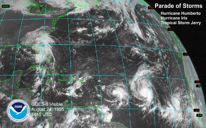
s. The first was with Hurricane Humberto
, while the second was with Tropical Storm Karen which was later absorbed by Iris. Iris produced torrential rainfall across the Leeward Islands
while at tropical storm strength. The rainfall caused isolated reports of landslides which killed five people.
on August 16. It moved westward with a disorganized center of circulation that persisted until August 19. On August 21, the tropical wave became Tropical Depression Ten, based on Dvorak technique
estimates. Six hours later, the depression became Tropical Storm Iris. Iris took a path to the northwest and quickly strengthened on August 23. On that day, a Hurricane Hunter
flight revealed that the winds were stronger than the satellite estimates. The data
from the reconnaissance flight prompted Iris to be upgraded to hurricane status.
 Iris then moved to the west-southwest at 12 miles per hour (19.3 km/h). The change in course was due to the interaction with Hurricane Humberto which was 750 miles (1,207 km) away. On August 25, Iris then encountered an upper level low that was centered over Puerto Rico
. The low caused increased wind shear which weakened Iris back to tropical storm strength. In addition, steering currents ahead of the storm caused Iris to move northwestward through the entire length of the Leeward Islands
. As wind shear
decreased, Iris steadily strengthened as it moved on a northward path away from the Leeward Islands
where it regained hurricane status on August 28. Two days later, Iris underwent a second Fujiwhara interaction with Tropical Storm Karen. The interaction caused Karen to be absorbed by Iris by September 3, resulting in Iris' storm path briefly becoming erratic. Iris reached a peak intensity of 110 miles per hour (177 km/h) and a minimum barometric pressure of 965 mb before transversing into a powerful extratropical storm
. The extratropical remnants of Iris struck northwestern Europe
on September 7.
 Forecasters at the National Hurricane Center
issued a tropical storm watch for the Leeward Islands
. The French
government also issued advisories for Martinique
and Guadeloupe
. The following day, the tropical storm watches were changed to tropical storm warnings as Iris drifted closer. The British Virgin Islands
were placed under a tropical storm watch which later changed to a warning on August 26.
In Trinidad and Tobago
, a feeder band from Iris brought 37 miles per hour (59.5 km/h) winds from the south. The winds caused heavy seas and minor damage to small boats. A weather station east of Guadeloupe
recorded 52 mph (83.7 km/h) winds with gusts up to 62 mph (100 km/h). Winds ranging from 41 to 56 mph (66 to 90.1 km/h) were reported in the Leeward Islands
. In addition to the winds, Iris produced heavy rainfall across the Leeward Islands
. Rainfall up to 17.2 inches (43.7 cm) were reported in Martinique
while 6 in (15.2 cm) of rain fell in Antigua
. The heavy rains caused numerous landslides that killed four people in Martinique
and one in Guadeloupe
. Rainfall also caused flooding in Antigua
and the rest of the Leeward Islands
.
Tropical cyclone
A tropical cyclone is a storm system characterized by a large low-pressure center and numerous thunderstorms that produce strong winds and heavy rain. Tropical cyclones strengthen when water evaporated from the ocean is released as the saturated air rises, resulting in condensation of water vapor...
and fifth hurricane of an active 1995 Atlantic hurricane season
1995 Atlantic hurricane season
The 1995 Atlantic hurricane season was the third most active Atlantic hurricane season on record. It officially began on June 1, 1995, and lasted until November 30, 1995. These dates conventionally delimit the period of each year when most tropical cyclones form in the north Atlantic ocean...
. Iris was one of four storms to form nearly simultaneously in the Atlantic
Atlantic Ocean
The Atlantic Ocean is the second-largest of the world's oceanic divisions. With a total area of about , it covers approximately 20% of the Earth's surface and about 26% of its water surface area...
during the 1995 season. Forming on August 22, Iris slowly drifted across the Leeward Islands
Leeward Islands
The Leeward Islands are a group of islands in the West Indies. They are the northern islands of the Lesser Antilles chain. As a group they start east of Puerto Rico and reach southward to Dominica. They are situated where the northeastern Caribbean Sea meets the western Atlantic Ocean...
as a tropical storm before reaching hurricane strength. After peaking at Category 2 strength, Iris then accelerated and became extratropical
Extratropical cyclone
Extratropical cyclones, sometimes called mid-latitude cyclones or wave cyclones, are a group of cyclones defined as synoptic scale low pressure weather systems that occur in the middle latitudes of the Earth having neither tropical nor polar characteristics, and are connected with fronts and...
on September 7. Iris' remnants reached western Europe
Europe
Europe is, by convention, one of the world's seven continents. Comprising the westernmost peninsula of Eurasia, Europe is generally 'divided' from Asia to its east by the watershed divides of the Ural and Caucasus Mountains, the Ural River, the Caspian and Black Seas, and the waterways connecting...
as a 75 mph (121 km/h) extratropical storm.
During its life cycle, Iris made two Fujiwhara interaction
Fujiwhara effect
The Fujiwhara effect or Fujiwara interaction, named after Sakuhei Fujiwhara, is a type of interaction between two nearby cyclonic vortices, causing them to appear to "orbit" each other.-Description:...
s. The first was with Hurricane Humberto
Hurricane Humberto (1995)
Hurricane Humberto was the eighth named storm and fourth hurricane of the busy 1995 Atlantic hurricane season. This was the first time that the name "Humberto" was used as it replaced Hugo...
, while the second was with Tropical Storm Karen which was later absorbed by Iris. Iris produced torrential rainfall across the Leeward Islands
Leeward Islands
The Leeward Islands are a group of islands in the West Indies. They are the northern islands of the Lesser Antilles chain. As a group they start east of Puerto Rico and reach southward to Dominica. They are situated where the northeastern Caribbean Sea meets the western Atlantic Ocean...
while at tropical storm strength. The rainfall caused isolated reports of landslides which killed five people.
Meteorological history
Iris began as a tropical wave that moved off the coast of AfricaAfrica
Africa is the world's second largest and second most populous continent, after Asia. At about 30.2 million km² including adjacent islands, it covers 6% of the Earth's total surface area and 20.4% of the total land area...
on August 16. It moved westward with a disorganized center of circulation that persisted until August 19. On August 21, the tropical wave became Tropical Depression Ten, based on Dvorak technique
Dvorak technique
The Dvorak technique is a widely used system to subjectively estimate tropical cyclone intensity based solely on visible and infrared satellite images. Several agencies issue Dvorak intensity numbers for cyclones of sufficient intensity...
estimates. Six hours later, the depression became Tropical Storm Iris. Iris took a path to the northwest and quickly strengthened on August 23. On that day, a Hurricane Hunter
Hurricane Hunters
The Hurricane Hunters are aircraft that fly into tropical cyclones in the North Atlantic Ocean and Northeastern Pacific Ocean for the specific purpose of directly measuring weather data in and around those storms. In the United States, the Air Force, Navy, and NOAA units have all participated in...
flight revealed that the winds were stronger than the satellite estimates. The data
from the reconnaissance flight prompted Iris to be upgraded to hurricane status.
Puerto Rico
Puerto Rico , officially the Commonwealth of Puerto Rico , is an unincorporated territory of the United States, located in the northeastern Caribbean, east of the Dominican Republic and west of both the United States Virgin Islands and the British Virgin Islands.Puerto Rico comprises an...
. The low caused increased wind shear which weakened Iris back to tropical storm strength. In addition, steering currents ahead of the storm caused Iris to move northwestward through the entire length of the Leeward Islands
Leeward Islands
The Leeward Islands are a group of islands in the West Indies. They are the northern islands of the Lesser Antilles chain. As a group they start east of Puerto Rico and reach southward to Dominica. They are situated where the northeastern Caribbean Sea meets the western Atlantic Ocean...
. As wind shear
Wind shear
Wind shear, sometimes referred to as windshear or wind gradient, is a difference in wind speed and direction over a relatively short distance in the atmosphere...
decreased, Iris steadily strengthened as it moved on a northward path away from the Leeward Islands
Leeward Islands
The Leeward Islands are a group of islands in the West Indies. They are the northern islands of the Lesser Antilles chain. As a group they start east of Puerto Rico and reach southward to Dominica. They are situated where the northeastern Caribbean Sea meets the western Atlantic Ocean...
where it regained hurricane status on August 28. Two days later, Iris underwent a second Fujiwhara interaction with Tropical Storm Karen. The interaction caused Karen to be absorbed by Iris by September 3, resulting in Iris' storm path briefly becoming erratic. Iris reached a peak intensity of 110 miles per hour (177 km/h) and a minimum barometric pressure of 965 mb before transversing into a powerful extratropical storm
Extratropical cyclone
Extratropical cyclones, sometimes called mid-latitude cyclones or wave cyclones, are a group of cyclones defined as synoptic scale low pressure weather systems that occur in the middle latitudes of the Earth having neither tropical nor polar characteristics, and are connected with fronts and...
. The extratropical remnants of Iris struck northwestern Europe
Europe
Europe is, by convention, one of the world's seven continents. Comprising the westernmost peninsula of Eurasia, Europe is generally 'divided' from Asia to its east by the watershed divides of the Ural and Caucasus Mountains, the Ural River, the Caspian and Black Seas, and the waterways connecting...
on September 7.
Preparations, Impact and Naming
National Hurricane Center
The National Hurricane Center , located at Florida International University in Miami, Florida, is the division of the National Weather Service responsible for tracking and predicting weather systems within the tropics between the Prime Meridian and the 140th meridian west poleward to the 30th...
issued a tropical storm watch for the Leeward Islands
Leeward Islands
The Leeward Islands are a group of islands in the West Indies. They are the northern islands of the Lesser Antilles chain. As a group they start east of Puerto Rico and reach southward to Dominica. They are situated where the northeastern Caribbean Sea meets the western Atlantic Ocean...
. The French
France
The French Republic , The French Republic , The French Republic , (commonly known as France , is a unitary semi-presidential republic in Western Europe with several overseas territories and islands located on other continents and in the Indian, Pacific, and Atlantic oceans. Metropolitan France...
government also issued advisories for Martinique
Martinique
Martinique is an island in the eastern Caribbean Sea, with a land area of . Like Guadeloupe, it is an overseas region of France, consisting of a single overseas department. To the northwest lies Dominica, to the south St Lucia, and to the southeast Barbados...
and Guadeloupe
Guadeloupe
Guadeloupe is an archipelago located in the Leeward Islands, in the Lesser Antilles, with a land area of 1,628 square kilometres and a population of 400,000. It is the first overseas region of France, consisting of a single overseas department. As with the other overseas departments, Guadeloupe...
. The following day, the tropical storm watches were changed to tropical storm warnings as Iris drifted closer. The British Virgin Islands
British Virgin Islands
The Virgin Islands, often called the British Virgin Islands , is a British overseas territory and overseas territory of the European Union, located in the Caribbean to the east of Puerto Rico. The islands make up part of the Virgin Islands archipelago, the remaining islands constituting the U.S...
were placed under a tropical storm watch which later changed to a warning on August 26.
In Trinidad and Tobago
Trinidad and Tobago
Trinidad and Tobago officially the Republic of Trinidad and Tobago is an archipelagic state in the southern Caribbean, lying just off the coast of northeastern Venezuela and south of Grenada in the Lesser Antilles...
, a feeder band from Iris brought 37 miles per hour (59.5 km/h) winds from the south. The winds caused heavy seas and minor damage to small boats. A weather station east of Guadeloupe
Guadeloupe
Guadeloupe is an archipelago located in the Leeward Islands, in the Lesser Antilles, with a land area of 1,628 square kilometres and a population of 400,000. It is the first overseas region of France, consisting of a single overseas department. As with the other overseas departments, Guadeloupe...
recorded 52 mph (83.7 km/h) winds with gusts up to 62 mph (100 km/h). Winds ranging from 41 to 56 mph (66 to 90.1 km/h) were reported in the Leeward Islands
Leeward Islands
The Leeward Islands are a group of islands in the West Indies. They are the northern islands of the Lesser Antilles chain. As a group they start east of Puerto Rico and reach southward to Dominica. They are situated where the northeastern Caribbean Sea meets the western Atlantic Ocean...
. In addition to the winds, Iris produced heavy rainfall across the Leeward Islands
Leeward Islands
The Leeward Islands are a group of islands in the West Indies. They are the northern islands of the Lesser Antilles chain. As a group they start east of Puerto Rico and reach southward to Dominica. They are situated where the northeastern Caribbean Sea meets the western Atlantic Ocean...
. Rainfall up to 17.2 inches (43.7 cm) were reported in Martinique
Martinique
Martinique is an island in the eastern Caribbean Sea, with a land area of . Like Guadeloupe, it is an overseas region of France, consisting of a single overseas department. To the northwest lies Dominica, to the south St Lucia, and to the southeast Barbados...
while 6 in (15.2 cm) of rain fell in Antigua
Antigua
Antigua , also known as Waladli, is an island in the West Indies, in the Leeward Islands in the Caribbean region, the main island of the country of Antigua and Barbuda. Antigua means "ancient" in Spanish and was named by Christopher Columbus after an icon in Seville Cathedral, Santa Maria de la...
. The heavy rains caused numerous landslides that killed four people in Martinique
Martinique
Martinique is an island in the eastern Caribbean Sea, with a land area of . Like Guadeloupe, it is an overseas region of France, consisting of a single overseas department. To the northwest lies Dominica, to the south St Lucia, and to the southeast Barbados...
and one in Guadeloupe
Guadeloupe
Guadeloupe is an archipelago located in the Leeward Islands, in the Lesser Antilles, with a land area of 1,628 square kilometres and a population of 400,000. It is the first overseas region of France, consisting of a single overseas department. As with the other overseas departments, Guadeloupe...
. Rainfall also caused flooding in Antigua
Antigua
Antigua , also known as Waladli, is an island in the West Indies, in the Leeward Islands in the Caribbean region, the main island of the country of Antigua and Barbuda. Antigua means "ancient" in Spanish and was named by Christopher Columbus after an icon in Seville Cathedral, Santa Maria de la...
and the rest of the Leeward Islands
Leeward Islands
The Leeward Islands are a group of islands in the West Indies. They are the northern islands of the Lesser Antilles chain. As a group they start east of Puerto Rico and reach southward to Dominica. They are situated where the northeastern Caribbean Sea meets the western Atlantic Ocean...
.