
Hurricane Hortense
Encyclopedia
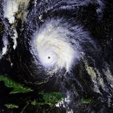
Hurricane Hortense was the eighth tropical storm, sixth hurricane, and second Category 4 hurricane
of the 1996 Atlantic hurricane season
. Lasting from September 3 to September 16, Hortense brought torrential flooding as it moved through the Lesser Antilles
, Puerto Rico
, and Dominican Republic
. Hitting only one year after Hurricanes Iris
, Luis
, Marilyn
and weeks after Hurricane Bertha
, it caused 39 deaths and $158 million (1996 US dollars) in damage.
on August 30 and moved westward. A well-defined low-level circulation quickly formed, but convection remained minimal due to strong upper level shear. The shear abated enough to allow shower activity to refire, and the system became Tropical Depression Eight on September 3. As it moved westward under the influence of a high pressure system, convection around the depression remained minimal due to persistent shear. As the depression approached the Lesser Antilles
, upper level shear rapidly lessened, and it was able to organize into Tropical Storm Hortense on the September 7.
Hortense moved slowly through the Leeward Islands
late on September 7 and into September 8, and despite initial forecasts of quick strengthening to hurricane status, Hortense encountered shear from a fast moving upper-level short trough. Shear quickly abated, and Hortense was able to reach hurricane strength on September 9 while in the northeast Caribbean Sea
. The large hurricane turned to the northwest, and passed over southwestern Puerto Rico
near Guánica
. After two hours over land, it entered the Mona Passage
, and paralleled the northeast coast of Dominican Republic
as an 80 mph (130 km/h) hurricane.
 Hurricane Hortense moved northwestward over the Atlantic Ocean
, passing north of the Turks and Caicos Islands
, where hurricane conditions were reported. Conditions became ideal for development, and the hurricane rapidly intensified to a 140 mph (220 km/h) Category 4 hurricane on September 13, but it was a relatively small system. A developing trough brought Hortense quickly to the northeast, producing shear that rapidly weakened the hurricane. As a Category 1 hurricane on September 15, Hortense crossed over the southeastern Nova Scotia
n coastline, and turned eastward. Later that day the storm became extratropical while south of Newfoundland
, and dissipated on September 16 over the open North Atlantic.
. At its height, a local weather station recorded wind speeds of up to 53 mph (85 km/h), with peak gusts surpassing hurricane force. The storm caused significant crop damage, destroying roughly 50 percent of the banana plantain. Further south, heavy rains led to scattered flooding in Martinique
, although there were no reports of considerable damage.
 Puerto Rico
received the worst of the storm, with over 24 in (600 mm) of rain falling in the eastern mountainous region of the island. Ensuing extreme flooding led to numerous mudslides, overflowing many rivers and damaging 11,463 houses. Some 1,400,000 people, about 40% of the population, lost power during and after the storm, straining the cleanup effort in the following days and weeks with lack of air conditioning and spoiled food. Much of eastern Puerto Rico was declared a federal disaster zone in the period after the storm. In all, Hortense was responsible for 18 deaths, and $155 million in damage, 80% of it from coffee and banana crop damage.
 Heavy damage was also experienced in Dominican Republic
, where nearly 20 in (510 mm) of rain occurred. One school and one church were destroyed by strong winds, with significant property damage in the northeast part of the country. A nine-foot storm surge combined with the rainfall caused three deaths (with 21 missing) and significant crop damage.
The Bahamas, threatened by their second major hurricane in two weeks, fared well from the storm, with little damage and no casualties.
In Nova Scotia
, Hortense dropped heavy rainfall and caused strong winds, causing power outages, uprooted trees, and moderate structural damage amounting to $3 million (1996 USD
).
, and will not be used again in this basin. It was replaced with Hanna in the 2002 season
.
Saffir-Simpson Hurricane Scale
The Saffir–Simpson Hurricane Scale , or the Saffir–Simpson Hurricane Wind Scale , classifies hurricanes — Western Hemisphere tropical cyclones that exceed the intensities of tropical depressions and tropical storms — into five categories distinguished by the intensities of their sustained winds...
of the 1996 Atlantic hurricane season
1996 Atlantic hurricane season
The 1996 Atlantic hurricane season was the first season since 1965 in which all tropical cyclones reached tropical storm status. It officially began on June 1, 1996, and lasted until November 30, 1996...
. Lasting from September 3 to September 16, Hortense brought torrential flooding as it moved through the Lesser Antilles
Lesser Antilles
The Lesser Antilles are a long, partly volcanic island arc in the Western Hemisphere. Most of its islands form the eastern boundary of the Caribbean Sea with the Atlantic Ocean, with the remainder located in the southern Caribbean just north of South America...
, Puerto Rico
Puerto Rico
Puerto Rico , officially the Commonwealth of Puerto Rico , is an unincorporated territory of the United States, located in the northeastern Caribbean, east of the Dominican Republic and west of both the United States Virgin Islands and the British Virgin Islands.Puerto Rico comprises an...
, and Dominican Republic
Dominican Republic
The Dominican Republic is a nation on the island of La Hispaniola, part of the Greater Antilles archipelago in the Caribbean region. The western third of the island is occupied by the nation of Haiti, making Hispaniola one of two Caribbean islands that are shared by two countries...
. Hitting only one year after Hurricanes Iris
Hurricane Iris (1995)
Hurricane Iris was the ninth named tropical cyclone and fifth hurricane of an active 1995 Atlantic hurricane season. Iris was one of four storms to form nearly simultaneously in the Atlantic during the 1995 season. Forming on August 22, Iris slowly drifted across the Leeward Islands as a tropical...
, Luis
Hurricane Luis
Hurricane Luis was one of the deadliest and most destructive hurricanes of the 1995 Atlantic hurricane season, with maximum sustained winds of 140 mph . The storm was the twelfth tropical storm, sixth hurricane, and second major hurricane of the season...
, Marilyn
Hurricane Marilyn
Hurricane Marilyn was the fifteenth tropical depression and thirteenth named storm of the unusually busy 1995 Atlantic hurricane season, following closely on the heels of Hurricane Luis. Hurricane Marilyn was the most powerful storm to hit the Virgin Islands since Hurricane Hugo of 1989.Marilyn...
and weeks after Hurricane Bertha
Hurricane Bertha (1996)
Hurricane Bertha was a strong, early season major hurricane which impacted areas from the Leeward Islands to Atlantic Canada. Bertha originated from a tropical wave which moved off the eastern coast of Africa in early July. By July 3, an area of low pressure developed along the wave...
, it caused 39 deaths and $158 million (1996 US dollars) in damage.
Meteorological history
A strong low-pressure system exited the coast of SenegalSenegal
Senegal , officially the Republic of Senegal , is a country in western Africa. It owes its name to the Sénégal River that borders it to the east and north...
on August 30 and moved westward. A well-defined low-level circulation quickly formed, but convection remained minimal due to strong upper level shear. The shear abated enough to allow shower activity to refire, and the system became Tropical Depression Eight on September 3. As it moved westward under the influence of a high pressure system, convection around the depression remained minimal due to persistent shear. As the depression approached the Lesser Antilles
Lesser Antilles
The Lesser Antilles are a long, partly volcanic island arc in the Western Hemisphere. Most of its islands form the eastern boundary of the Caribbean Sea with the Atlantic Ocean, with the remainder located in the southern Caribbean just north of South America...
, upper level shear rapidly lessened, and it was able to organize into Tropical Storm Hortense on the September 7.
Hortense moved slowly through the Leeward Islands
Leeward Islands
The Leeward Islands are a group of islands in the West Indies. They are the northern islands of the Lesser Antilles chain. As a group they start east of Puerto Rico and reach southward to Dominica. They are situated where the northeastern Caribbean Sea meets the western Atlantic Ocean...
late on September 7 and into September 8, and despite initial forecasts of quick strengthening to hurricane status, Hortense encountered shear from a fast moving upper-level short trough. Shear quickly abated, and Hortense was able to reach hurricane strength on September 9 while in the northeast Caribbean Sea
Caribbean Sea
The Caribbean Sea is a sea of the Atlantic Ocean located in the tropics of the Western hemisphere. It is bounded by Mexico and Central America to the west and southwest, to the north by the Greater Antilles, and to the east by the Lesser Antilles....
. The large hurricane turned to the northwest, and passed over southwestern Puerto Rico
Puerto Rico
Puerto Rico , officially the Commonwealth of Puerto Rico , is an unincorporated territory of the United States, located in the northeastern Caribbean, east of the Dominican Republic and west of both the United States Virgin Islands and the British Virgin Islands.Puerto Rico comprises an...
near Guánica
Guánica, Puerto Rico
Guánica is a municipality in southwestern Puerto Rico located on southern coast, bordering the Caribbean Sea, south of Sabana Grande, east of Lajas, and west of Yauco. It is part of the Yauco Metropolitan Statistical Area....
. After two hours over land, it entered the Mona Passage
Mona Passage
The Mona Passage is a strait that separates the islands of Hispaniola and Puerto Rico. The Mona Passage connects the Atlantic Ocean to the Caribbean Sea, and is an important shipping route between the Atlantic and the Panama Canal....
, and paralleled the northeast coast of Dominican Republic
Dominican Republic
The Dominican Republic is a nation on the island of La Hispaniola, part of the Greater Antilles archipelago in the Caribbean region. The western third of the island is occupied by the nation of Haiti, making Hispaniola one of two Caribbean islands that are shared by two countries...
as an 80 mph (130 km/h) hurricane.
Atlantic Ocean
The Atlantic Ocean is the second-largest of the world's oceanic divisions. With a total area of about , it covers approximately 20% of the Earth's surface and about 26% of its water surface area...
, passing north of the Turks and Caicos Islands
Turks and Caicos Islands
The Turks and Caicos Islands are a British Overseas Territory and overseas territory of the European Union consisting of two groups of tropical islands in the Caribbean, the larger Caicos Islands and the smaller Turks Islands, known for tourism and as an offshore financial centre.The Turks and...
, where hurricane conditions were reported. Conditions became ideal for development, and the hurricane rapidly intensified to a 140 mph (220 km/h) Category 4 hurricane on September 13, but it was a relatively small system. A developing trough brought Hortense quickly to the northeast, producing shear that rapidly weakened the hurricane. As a Category 1 hurricane on September 15, Hortense crossed over the southeastern Nova Scotia
Nova Scotia
Nova Scotia is one of Canada's three Maritime provinces and is the most populous province in Atlantic Canada. The name of the province is Latin for "New Scotland," but "Nova Scotia" is the recognized, English-language name of the province. The provincial capital is Halifax. Nova Scotia is the...
n coastline, and turned eastward. Later that day the storm became extratropical while south of Newfoundland
Newfoundland and Labrador
Newfoundland and Labrador is the easternmost province of Canada. Situated in the country's Atlantic region, it incorporates the island of Newfoundland and mainland Labrador with a combined area of . As of April 2011, the province's estimated population is 508,400...
, and dissipated on September 16 over the open North Atlantic.
Impact
| Region | Deaths |
|---|---|
| Puerto Rico Puerto Rico Puerto Rico , officially the Commonwealth of Puerto Rico , is an unincorporated territory of the United States, located in the northeastern Caribbean, east of the Dominican Republic and west of both the United States Virgin Islands and the British Virgin Islands.Puerto Rico comprises an... |
18 |
| Dominican Republic Dominican Republic The Dominican Republic is a nation on the island of La Hispaniola, part of the Greater Antilles archipelago in the Caribbean region. The western third of the island is occupied by the nation of Haiti, making Hispaniola one of two Caribbean islands that are shared by two countries... |
3 |
| Total | 21 http://www.nhc.noaa.gov/1996hortense.html |
Lesser Antilles
Before becoming a hurricane, Hortense struck the Leeward Islands as a very moist tropical storm, producing as much as 12.50 in (381 mm) of rain when passing over GuadeloupeGuadeloupe
Guadeloupe is an archipelago located in the Leeward Islands, in the Lesser Antilles, with a land area of 1,628 square kilometres and a population of 400,000. It is the first overseas region of France, consisting of a single overseas department. As with the other overseas departments, Guadeloupe...
. At its height, a local weather station recorded wind speeds of up to 53 mph (85 km/h), with peak gusts surpassing hurricane force. The storm caused significant crop damage, destroying roughly 50 percent of the banana plantain. Further south, heavy rains led to scattered flooding in Martinique
Martinique
Martinique is an island in the eastern Caribbean Sea, with a land area of . Like Guadeloupe, it is an overseas region of France, consisting of a single overseas department. To the northwest lies Dominica, to the south St Lucia, and to the southeast Barbados...
, although there were no reports of considerable damage.
Greater Antilles
Puerto Rico
Puerto Rico , officially the Commonwealth of Puerto Rico , is an unincorporated territory of the United States, located in the northeastern Caribbean, east of the Dominican Republic and west of both the United States Virgin Islands and the British Virgin Islands.Puerto Rico comprises an...
received the worst of the storm, with over 24 in (600 mm) of rain falling in the eastern mountainous region of the island. Ensuing extreme flooding led to numerous mudslides, overflowing many rivers and damaging 11,463 houses. Some 1,400,000 people, about 40% of the population, lost power during and after the storm, straining the cleanup effort in the following days and weeks with lack of air conditioning and spoiled food. Much of eastern Puerto Rico was declared a federal disaster zone in the period after the storm. In all, Hortense was responsible for 18 deaths, and $155 million in damage, 80% of it from coffee and banana crop damage.
Dominican Republic
The Dominican Republic is a nation on the island of La Hispaniola, part of the Greater Antilles archipelago in the Caribbean region. The western third of the island is occupied by the nation of Haiti, making Hispaniola one of two Caribbean islands that are shared by two countries...
, where nearly 20 in (510 mm) of rain occurred. One school and one church were destroyed by strong winds, with significant property damage in the northeast part of the country. A nine-foot storm surge combined with the rainfall caused three deaths (with 21 missing) and significant crop damage.
The Bahamas, threatened by their second major hurricane in two weeks, fared well from the storm, with little damage and no casualties.
In Nova Scotia
Nova Scotia
Nova Scotia is one of Canada's three Maritime provinces and is the most populous province in Atlantic Canada. The name of the province is Latin for "New Scotland," but "Nova Scotia" is the recognized, English-language name of the province. The provincial capital is Halifax. Nova Scotia is the...
, Hortense dropped heavy rainfall and caused strong winds, causing power outages, uprooted trees, and moderate structural damage amounting to $3 million (1996 USD
United States dollar
The United States dollar , also referred to as the American dollar, is the official currency of the United States of America. It is divided into 100 smaller units called cents or pennies....
).
Retirement
The name Hortense was retired in the Spring of 1997 because of this hurricaneTropical cyclone
A tropical cyclone is a storm system characterized by a large low-pressure center and numerous thunderstorms that produce strong winds and heavy rain. Tropical cyclones strengthen when water evaporated from the ocean is released as the saturated air rises, resulting in condensation of water vapor...
, and will not be used again in this basin. It was replaced with Hanna in the 2002 season
2002 Atlantic hurricane season
The 2002 Atlantic hurricane season was an average Atlantic hurricane season, officially starting on June 1, 2002 and ending on November 30, dates which conventionally limit the period of each year when tropical cyclones in the Atlantic Ocean tend to form...
.
See also
- List of Atlantic hurricanes
- List of retired Atlantic hurricane names