
.gif)
Hurricane Jose (1999)
Encyclopedia
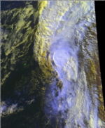
Hurricane Jose was a Category 2 hurricane that affected the Leeward Islands
between October 20 and October 25, 1999. It was the tenth named storm, and eighth hurricane of the 1999 Atlantic hurricane season
. Jose formed on October 17 while 400 miles (643.7 km) east of the Windward Islands
. The storm quickly strengthened into a hurricane on October 19, and later went on to affect the northern Leeward Islands. Over a foot of rain fell on St. Martin and other islands that were affected by it. It weakened to a tropical storm as it approached the U.S. Virgin Islands and as it neared Puerto Rico
, Jose turned to the north-northeast. Jose remained on a near-straight line track into the north Atlantic until it lost its tropical characteristics on October 25. It then merged with a non-tropical system.
The storm caused one death in Antigua and one in St. Martin. Extensive damage was reported in St. Martin from flooding and mud slides, but no damage total is attached to this. Damage to Puerto Rico
was minimal.
that moved of the west coast of Africa
on October 8. The tropical wave moved slowly westward for several days until it was halfway between the Lesser Antilles
and Africa
on October 15. On October 17, the system was declared a tropical depression at 1800 UTC near the Windward Islands
. While moving west-northwestward, the depression was upgraded to tropical storm status and was named Jose on October 18.
By October 19, a strong mid-tropospheric high over the southwestern north Atlantic was predicted to steer Tropical Storm Jose to a west-northwestward track. Instead, the high weakened and Jose continued on a north-westerly track. Jose became a hurricane on October 19 and was centered about 150 miles (241.4 km) east of the Leeward Islands
. As it neared the islands, Jose reached a peak of 100 mph (160.9 km/h) in wind speed, and 979 mbar (28.9 inHg) in pressure.
 Turning back on a northwest direction, Hurricane Jose struck the northern Leeward Islands
, passing over Antigua
around midday on October 20. The center of the storm then moved near St. Barthelemy and St. Martin on October 21. As Jose moved over the Leeward Islands
, strong vertical wind shear disrupted the storm and Jose weakened to a tropical storm, while passing over Tortola
in the British Virgin Islands
on October 21. On the same day, Jose turned back to the northwest as the center passed 50 miles (80.5 km) east of Puerto Rico
.
Jose turned sharply north and northeast, after passing just to the north of Puerto Rico. Jose continued on a northerly track, while slowly restrengthening and accelerating throughout the next couple of days. Jose then briefly regained hurricane strength as it passed east of Bermuda
on October 23, with only light showers and gusty winds affecting the island. The storm continued northeastward before being declared an extratropical storm on August 25, when it merged with a mid-latitude system.
were strongly affected by the hurricane. The storm damage was severe on both of the islands while damage in St. Kitts and Nevis was minor, because the hurricane passed north of those islands.
 In St. Kitts and Nevis, flooding was the principal hazard as several main roads were washed out and landslides were reported. In St Maarten, maximal sustained wind was 65 knots and a 87 knots wind gust rainfall totaled to 13.75 inches (349.3 mm), though much of the Leeward Islands received 12 to 15 inches (381 mm) of rain. Because of the rain, numerous mudslides and flash floods were reported, damaging buildings and roads. One person was reported have perished due to the storm's ferocity. Dominica
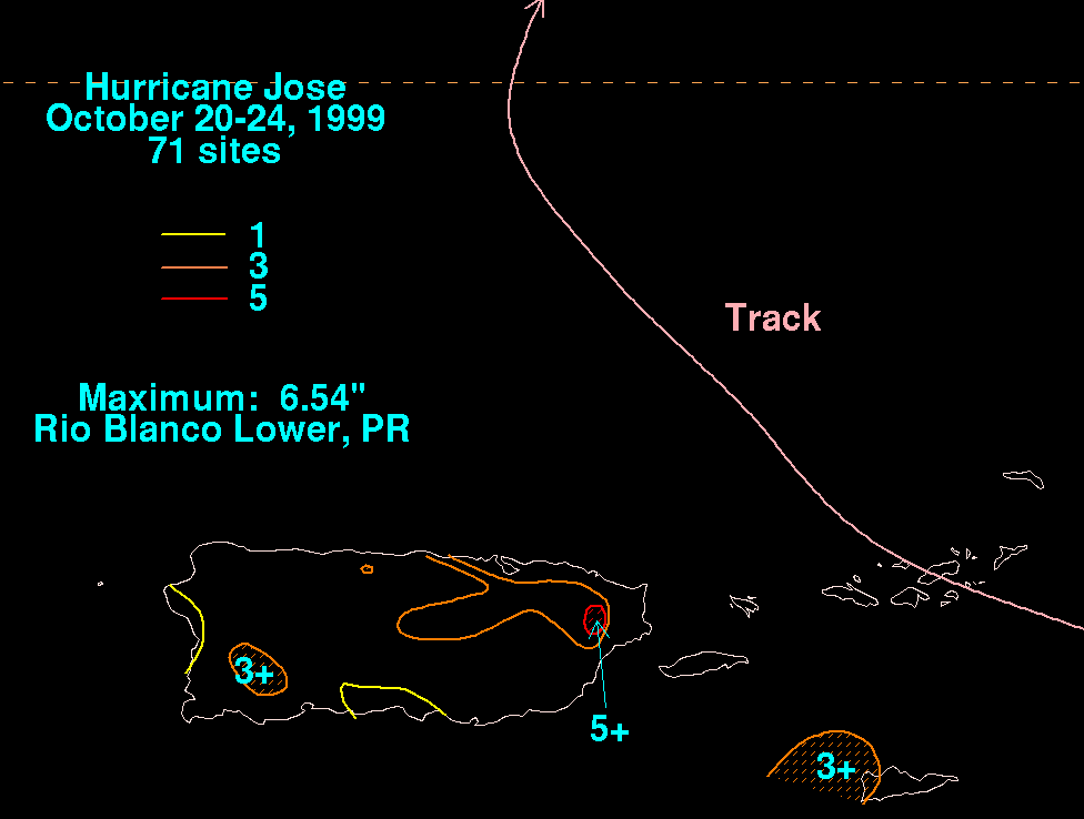
received no more than a little rain, only being persistent for one morning. Damage in Puerto Rico was minimal, though up to 5 inches (127 mm) of rain fell in some areas on the island. The highest reported rainfall there was 6.54 inches (166.1 mm) in Rio Blanco Lower.
Hurricane Jose will return as the name of the tenth tropical storm of the 2011 season.
Leeward Islands
The Leeward Islands are a group of islands in the West Indies. They are the northern islands of the Lesser Antilles chain. As a group they start east of Puerto Rico and reach southward to Dominica. They are situated where the northeastern Caribbean Sea meets the western Atlantic Ocean...
between October 20 and October 25, 1999. It was the tenth named storm, and eighth hurricane of the 1999 Atlantic hurricane season
1999 Atlantic hurricane season
The 1999 Atlantic hurricane season officially began on June 1, 1999, and lasted until November 30, 1999. These dates conventionally delimit the period of each year when most tropical cyclones form in the Atlantic basin....
. Jose formed on October 17 while 400 miles (643.7 km) east of the Windward Islands
Windward Islands
The Windward Islands are the southern islands of the Lesser Antilles, within the West Indies.-Name and geography:The Windward Islands are called such because they were more windward to sailing ships arriving in the New World than the Leeward Islands, given that the prevailing trade winds in the...
. The storm quickly strengthened into a hurricane on October 19, and later went on to affect the northern Leeward Islands. Over a foot of rain fell on St. Martin and other islands that were affected by it. It weakened to a tropical storm as it approached the U.S. Virgin Islands and as it neared Puerto Rico
Puerto Rico
Puerto Rico , officially the Commonwealth of Puerto Rico , is an unincorporated territory of the United States, located in the northeastern Caribbean, east of the Dominican Republic and west of both the United States Virgin Islands and the British Virgin Islands.Puerto Rico comprises an...
, Jose turned to the north-northeast. Jose remained on a near-straight line track into the north Atlantic until it lost its tropical characteristics on October 25. It then merged with a non-tropical system.
The storm caused one death in Antigua and one in St. Martin. Extensive damage was reported in St. Martin from flooding and mud slides, but no damage total is attached to this. Damage to Puerto Rico
Puerto Rico
Puerto Rico , officially the Commonwealth of Puerto Rico , is an unincorporated territory of the United States, located in the northeastern Caribbean, east of the Dominican Republic and west of both the United States Virgin Islands and the British Virgin Islands.Puerto Rico comprises an...
was minimal.
Meteorological history
Hurricane Jose originated from a tropical waveTropical wave
Tropical waves, easterly waves, or tropical easterly waves, also known as African easterly waves in the Atlantic region, are a type of atmospheric trough, an elongated area of relatively low air pressure, oriented north to south, which move from east to west across the tropics causing areas of...
that moved of the west coast of Africa
Africa
Africa is the world's second largest and second most populous continent, after Asia. At about 30.2 million km² including adjacent islands, it covers 6% of the Earth's total surface area and 20.4% of the total land area...
on October 8. The tropical wave moved slowly westward for several days until it was halfway between the Lesser Antilles
Lesser Antilles
The Lesser Antilles are a long, partly volcanic island arc in the Western Hemisphere. Most of its islands form the eastern boundary of the Caribbean Sea with the Atlantic Ocean, with the remainder located in the southern Caribbean just north of South America...
and Africa
Africa
Africa is the world's second largest and second most populous continent, after Asia. At about 30.2 million km² including adjacent islands, it covers 6% of the Earth's total surface area and 20.4% of the total land area...
on October 15. On October 17, the system was declared a tropical depression at 1800 UTC near the Windward Islands
Windward Islands
The Windward Islands are the southern islands of the Lesser Antilles, within the West Indies.-Name and geography:The Windward Islands are called such because they were more windward to sailing ships arriving in the New World than the Leeward Islands, given that the prevailing trade winds in the...
. While moving west-northwestward, the depression was upgraded to tropical storm status and was named Jose on October 18.
By October 19, a strong mid-tropospheric high over the southwestern north Atlantic was predicted to steer Tropical Storm Jose to a west-northwestward track. Instead, the high weakened and Jose continued on a north-westerly track. Jose became a hurricane on October 19 and was centered about 150 miles (241.4 km) east of the Leeward Islands
Leeward Islands
The Leeward Islands are a group of islands in the West Indies. They are the northern islands of the Lesser Antilles chain. As a group they start east of Puerto Rico and reach southward to Dominica. They are situated where the northeastern Caribbean Sea meets the western Atlantic Ocean...
. As it neared the islands, Jose reached a peak of 100 mph (160.9 km/h) in wind speed, and 979 mbar (28.9 inHg) in pressure.
Leeward Islands
The Leeward Islands are a group of islands in the West Indies. They are the northern islands of the Lesser Antilles chain. As a group they start east of Puerto Rico and reach southward to Dominica. They are situated where the northeastern Caribbean Sea meets the western Atlantic Ocean...
, passing over Antigua
Antigua
Antigua , also known as Waladli, is an island in the West Indies, in the Leeward Islands in the Caribbean region, the main island of the country of Antigua and Barbuda. Antigua means "ancient" in Spanish and was named by Christopher Columbus after an icon in Seville Cathedral, Santa Maria de la...
around midday on October 20. The center of the storm then moved near St. Barthelemy and St. Martin on October 21. As Jose moved over the Leeward Islands
Leeward Islands
The Leeward Islands are a group of islands in the West Indies. They are the northern islands of the Lesser Antilles chain. As a group they start east of Puerto Rico and reach southward to Dominica. They are situated where the northeastern Caribbean Sea meets the western Atlantic Ocean...
, strong vertical wind shear disrupted the storm and Jose weakened to a tropical storm, while passing over Tortola
Tortola
Tortola is the largest and most populated of the British Virgin Islands, a group of islands that form part of the archipelago of the Virgin Islands. Local tradition recounts that Christopher Columbus named it Tortola, meaning "land of the Turtle Dove". Columbus named the island Santa Ana...
in the British Virgin Islands
British Virgin Islands
The Virgin Islands, often called the British Virgin Islands , is a British overseas territory and overseas territory of the European Union, located in the Caribbean to the east of Puerto Rico. The islands make up part of the Virgin Islands archipelago, the remaining islands constituting the U.S...
on October 21. On the same day, Jose turned back to the northwest as the center passed 50 miles (80.5 km) east of Puerto Rico
Puerto Rico
Puerto Rico , officially the Commonwealth of Puerto Rico , is an unincorporated territory of the United States, located in the northeastern Caribbean, east of the Dominican Republic and west of both the United States Virgin Islands and the British Virgin Islands.Puerto Rico comprises an...
.
Jose turned sharply north and northeast, after passing just to the north of Puerto Rico. Jose continued on a northerly track, while slowly restrengthening and accelerating throughout the next couple of days. Jose then briefly regained hurricane strength as it passed east of Bermuda
Bermuda
Bermuda is a British overseas territory in the North Atlantic Ocean. Located off the east coast of the United States, its nearest landmass is Cape Hatteras, North Carolina, about to the west-northwest. It is about south of Halifax, Nova Scotia, Canada, and northeast of Miami, Florida...
on October 23, with only light showers and gusty winds affecting the island. The storm continued northeastward before being declared an extratropical storm on August 25, when it merged with a mid-latitude system.
Preparations
Twenty-four shelters were set up to be used when Jose passed over, but only 506 people used the shelters.Impact
Antigua and BarbudaAntigua and Barbuda
Antigua and Barbuda is a twin-island nation lying between the Caribbean Sea and the Atlantic Ocean. It consists of two major inhabited islands, Antigua and Barbuda, and a number of smaller islands...
were strongly affected by the hurricane. The storm damage was severe on both of the islands while damage in St. Kitts and Nevis was minor, because the hurricane passed north of those islands.
Antigua and Barbuda
In Antigua and Barbuda, there was considerable flooding of major roads and 2,000 people were severely affected and were evacuated. About 516 of the people were housed in emergency shelters. Across the island, the storm killed one person, injured 12, left an elderly blind man missing, and 500 houses were destroyed including a newly built church. In the village of Crab´s Hill, 64 of the 81 houses were ether seriously damaged or destroyed. The hurricane also disrupted 50% of telephone service and 90% of the homes were left without electricity. A wind gust of 102 mph (164 km/h) was reported by the Antigua and Barbuda Meteorological Service on October 20.Rest of Caribbean
Dominica
Dominica , officially the Commonwealth of Dominica, is an island nation in the Lesser Antilles region of the Caribbean Sea, south-southeast of Guadeloupe and northwest of Martinique. Its size is and the highest point in the country is Morne Diablotins, which has an elevation of . The Commonwealth...
received no more than a little rain, only being persistent for one morning. Damage in Puerto Rico was minimal, though up to 5 inches (127 mm) of rain fell in some areas on the island. The highest reported rainfall there was 6.54 inches (166.1 mm) in Rio Blanco Lower.
Aftermath
After the storm, several villages in Antigua and Barbuda were declared disaster areas and Red Cross workers were called to clean up the damage.Hurricane Jose will return as the name of the tenth tropical storm of the 2011 season.
See also
- Tropical cycloneTropical cycloneA tropical cyclone is a storm system characterized by a large low-pressure center and numerous thunderstorms that produce strong winds and heavy rain. Tropical cyclones strengthen when water evaporated from the ocean is released as the saturated air rises, resulting in condensation of water vapor...
- List of tropical cyclones
- List of Atlantic hurricanes