
Hurricane Flora
Encyclopedia
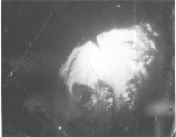
Hurricane Flora is among the deadliest Atlantic hurricanes in recorded history
, with a death total of over 7,000. The seventh tropical storm and sixth hurricane of the 1963 Atlantic hurricane season
, Flora developed from a disturbance in the Intertropical Convergence Zone
on September 26 while located about 755 miles (1,215.1 km) southwest of the Cape Verde
islands. After remaining a weak depression for several days, it rapidly organized on September 29 to attain tropical storm status. Flora continued to quickly strengthen to reach Category 3
hurricane status before moving through the Windward Islands
and passing over Tobago
, and it reached maximum sustained wind
s of 145 miles per hour (233.4 km/h) in the Caribbean.
The storm struck southwestern Haiti
near peak intensity, turned to the west, and drifted over Cuba
for four days before turning to the northeast. Flora passed through the Bahamas and accelerated northeastward, becoming an extratropical cyclone
on October 12. Due to its slow movement across Cuba, Flora is the wettest known tropical cyclone for Cuba, Haiti, and the Dominican Republic. The significant casualties caused by Flora were the most for a tropical cyclone in the Atlantic Basin since the 1900 Galveston Hurricane.
organized into a tropical depression on September 26 while located about 755 miles (1,215.1 km) southwest of the island of Fogo
in the Cape Verde Islands
. Upon forming, the depression had a poorly-organized circulation with banding features to its north and east. The depression moved west-northwestward, and the system failed to organize significantly by a day after developing. On September 27, the banding features dissipated, though the area of convection around the center increased. Satellite imagery was unavailable until September 30, during which there were not sufficient ship reports to indicate the presence of a low-level circulation. The depression continued west-northwestward, and it is estimated it intensified into Tropical Storm Flora on September 29 while located about 560 miles (901.2 km) east-southeast of Trinidad
, or about 350 miles (563.3 km) north of Cayenne
, French Guiana
. Operationally, advisories were not initiated until a day later.
Flora quickly intensified after it became a tropical storm, and early on September 30 it attained hurricane status. Later that day, Reconnaissance Aircraft
confirmed the existence of the hurricane, with the flight reporting a well-defined, circular 8 miles (12.9 km) wide eye
. One observer noted Flora to be the best organized tropical cyclone over the previous two years. After attaining major hurricane status, Flora passed directly over the island of Tobago
late on the 30th with winds of 120 mi/h. The hurricane continued west-northwestward as it entered the Caribbean, and early on October 2 it reached winds of 140 miles per hour (225.3 km/h). Thirty hours later, Flora intensified slightly further and attained peak winds of 145 mi/h while located about 105 miles (169 km) south of the border of Haiti
and the Dominican Republic
.
 After turning to the northwest, Hurricane Flora maintained its peak strength, and made landfall in the Sud Department
of Haiti late on October 3 as a 145 mi/h Category 4 hurricane on the Saffir-Simpson Scale
with gusts from 180 to 200 mph (289.7 to 321.9 km/h). The calm of the eye
lasted for up to 70 minutes in one location. After quickly weakening to a 120 mi/h hurricane, Flora turned more to the west in the Windward Passage
, and restrengthened slightly to strike southeastern Cuba
about 30 miles (48.3 km) east of Guantanamo Bay
with winds of 125 mi/h. A high pressure system
to its north turned the motion of the hurricane to a westward drift, causing it to weaken quickly over land. Flora neared the north coast of Cuba
on October 4 before turning to the south. It executed a cyclonic loop and entered the coastal waters off the Granma Province
. An anticyclone to the west of Flora turned the hurricane to the north, bringing it ashore near Santa Cruz del Sur
on October 7 with winds of around 90 mi/h. Flora initially turned southeastward over central Cuba, and late on October 8 a short-wave trough
turned the hurricane northeastward, bringing it into the coastal waters of the Holguín Province
. Flora remained a hurricane while drifting over land due to abundant moisture and a favorable upper level environment.
After passing over the southeastern Bahamas early on October 9, Flora began to restrengthen, and on October 10 it again reached major hurricane status while located 290 miles (466.7 km) south of Bermuda
. The hurricane gradually weakened as it continued northeastward, and weakened to a Category 1 hurricane on October 11. Flora gradually lost its convection over the north Atlantic Ocean, and transitioned into an extratropical cyclone
on October 12 while located 270 miles (434.5 km) east-southeast of Cape Race
, Newfoundland. The extratropical remnant dissipated the next day.
in San Juan, Puerto Rico
issued a hurricane warning
for Trinidad
, Tobago
, and the Grenadines
south of Saint Vincent
in the cyclone's first advisory on Hurricane Flora. Gale warnings were later issued for islands off northern Venezuela
and from Saint Vincent northward to Martinique
. Advisories on Flora emphasized the danger of the hurricane and advised preparations to be rushed to completion. The advisories also recommended small craft throughout the Windward Islands
to remain at harbor and for shipping in the path of the hurricane to advise extreme caution. People in low-lying areas and near beaches were advised to evacuate to higher grounds, as well. Lead time was short, especially in Tobago which received news of the approaching hurricane just two hours before it struck.
On October 2, two days before it made landfall on southwestern Hispaniola
, the San Juan Weather Bureau issued a gale warning from Barahona
in the Dominican Republic
to the Sud-Est Department
of Haiti
. Advisories recommended small craft in the southern portions of the countries to remain at port. Later that day, the gale warning was upgraded to a hurricane warning in southwestern Haiti. On the day of when Flora made landfall, advisories recommended all citizens on beaches and in low-lying areas west of Santo Domingo
to evacuate. Carmelo Di Franco, the provisional Director of Civic Defense for the Dominican Republic, organized safety procedures and the dissemination of tropical cyclone bulletins from the San Juan Weather Bureau. Di Franco also organized for the transmission of hurricane emergency information to citizens, believed to reduce the loss of life. On the afternoon before the hurricane struck, the head of the Haitian Red Cross
prohibited radio broadcasts of tropical cyclone advisories for fear of panic among citizens. As a result, many thought the hurricane would miss the country.
Officials at the Cuban National Observatory issued radio bulletins on the hurricane, which included the position of Flora, its intensity, direction of motion, and necessary warnings. By the time the hurricane left the island, more than 40,000 had been evacuated to safer areas.
The Weather Bureau predicted Flora to turn to the northwest after entering the Windward Passage
and affect the Bahamas. Forecasters advised those in The Bahamas to quickly complete preparations, though the eye of the hurricane did not pass over the archipelago until four days later. When Flora turned to the northeast out to sea, forecasters again advised Bahamian citizens to prepare for the hurricane, and on October 9, weather advisories advised the southeastern Bahamas to prepare for gale-force winds and strong tides. One advisory considered there to be less than a 50% chance of the hurricane reaching southeastern Florida
, though weather bulletins advised Florida citizens to monitor the hurricane. At its closest approach to Florida, the hurricane remained 330 miles (530 km) away, though gale warnings were issued from Stuart
to Key West
due to the hurricane's large size.
Throughout its path, Hurricane Flora resulted in more than 7,000 deaths and over $525 million in damage (1963 USD, $ USD). It is estimated that, if a hurricane like Flora had struck in 1998, it would have caused over 12,000 casualties.
a few days after Hurricane Edith moved through the area. The two hurricanes resulted in about $65,000 in damage (1963 USD), primarily to fishing interests.
About four hours before the eye
of Hurricane Flora moved over Tobago
, the large hurricane began producing heavy rainfall throughout the island. Two hours later, strong winds began affecting the island, and while moving across the island Flora produced winds of up to 100 miles per hour (160.9 km/h). While moving past Tobago, the hurricane produced rough surf and tides 5 to 7 ft (1.5 to 2.1 m) above normal. The hurricane sunk six ships between 4 to 9 tons in Scarborough harbour. One crew member drowned while attempting to save his vessel. Heavy rainfall caused a large mudslide from Mount Dillon onto a road leading to Castara
. This was considered the most well-known mudslide on the island. The strong winds caused severe damage to coconut
, banana
, and cocoa plantations, with 50% of the coconut trees being destroyed and another 11% being severely damaged. 75% of forest trees fell, and most of the remaining were greatly damaged. The passage of Hurricane Flora destroyed 2,750 of Tobago's 7,500 houses, and damaged 3,500 others. The hurricane killed 18 on the island and resulted in $30 million in crop and property damage (1963 USD).
Winds on Trinidad
reached 55 mi/h with much higher gusts of over 70 mi/h. Heavy rainfall and strong winds in the northern mountainous region lowered the visibility to zero. Due to the mountain range on its northern coast, damage on the island was minimal, totaling to $100,000 (1963 USD). Two people on the island died due to drowning. When Flora passed the island and the winds turned to the southwest, many small boats in the westward facing harbor were sunk. Near Chaguaramas, nine boats were destroyed and eight were damaged. Additionally, several large vessels sustained damage and resulted in them being intentionally sunk. Damage in Grenada
was minor, around $25,000 (1963 USD), though six people died due to drowning. Rough seas and higher than normal tides were reported along the south coast of Puerto Rico
, though no damage or deaths were reported there.
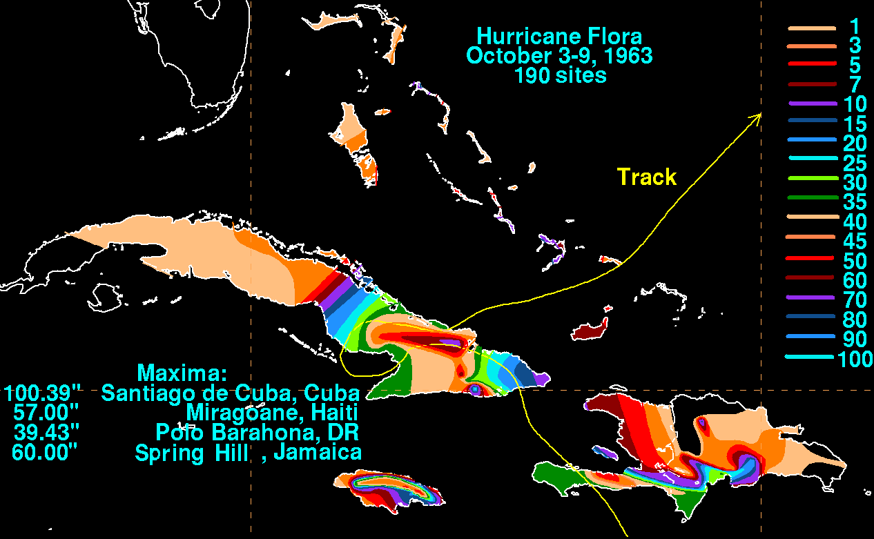
. The highest rainfall amount reported was 39.43 inches (1,001.5 mm) at Polo Barahona. Flooding from the hurricane, considered to be the most extensive on record, greatly damaged bridges and roads, with many roads left unpassable for several months after the hurricane struck. Over 3,800 sq. miles (10,000 km²) in the western portion of the country were flooded. The hurricane caused about $60 million in damage (1963 USD) and over 400 deaths.
While moving across southwestern Haiti
, Hurricane Flora produced winds of up to 120 mi/h near Derez, while the capital city of Port-au-Prince
reported peak winds of 65 mi/h. Intense rainband
s dropped torrential precipitation estimated at over 75 inches (1,905 mm) in Miragoâne
, with one location recording over 57 inches (1,447.8 mm) in three days. One location in the southwestern peninsula recorded 16 inches (406.4 mm) of precipitation in 12 hours. The storm surge
on the southern coast is unknown, but estimated to exceed 12 feet (3.7 m). Flash floods from the hurricane washed out large sections of several towns, while mudslides buried some entire towns, resulting in many deaths. Heavy rainfall led to river flooding along the Grisse River, which crested at 14 feet (4.3 m) above normal. The flood waters created new channels and washed away entire banana plantations.
In most areas, crops were entirely destroyed. The coffee
crop was harvested prior to the arrival of the hurricane, though heavy rainfall and severe flooding ruined the crop for later years. Additionally, strong winds downed shading trees for the coffee crop on the southern peninsula. One official estimated it would require three years for the coffee crop to be replanted and regrown.
Strong winds in southwestern Haiti from the hurricane damaged or destroyed hundreds of trees. The path of Flora over the area was best determined by the trajectory of fallen trees across the peninsula. The strong winds left entire villages roofless, with many buildings entirely destroyed. The combination of rough waves and strong winds destroyed three entire communities. Many of those who died in southwestern Haiti suffered from intense burns from strong winds.
About 3,500 people were confirmed dead, with several thousands missing at one report five months after the hurricane. It is estimated the passage of Hurricane Flora killed around 5,000 people and caused between $125 million and $180 million in damage in Haiti (1963 USD).
n province of Camagüey
by up to 1 kilometres (3,280.8 ft). Santa Cruz del Sur
reported strong southerly winds and rough seas. Winds in Cuba reached 125 miles per hour (201.2 km/h). Nearly all crops in southeastern Cuba were affected by strong winds and flooding. Many citizens were left stranded at the tops of their houses. Several entire houses were swept away by the flooding, and many roads and bridges were destroyed, resulting in major disruptions to communications. Isolated locations in Cuba received over 80 inches (2,032 mm) of rain, with Santiago de Cuba recording 100.39 inches (2,549.9 mm), which is the highest rainfall total measured on Cuba from any rainfall event on record.
Heavy rainfall fell across the island of Jamaica due to persistent southwest flow into the mountains on Flora's southern periphery over several days. The maximum amount recorded was 60 inches (1,524 mm) at Spring Hill. Damage to the island totaled $11.9 million (1963 dollars). Rough seas from Flora affected the Bahamas and the southeastern Florida coast on October 5 as the hurricane stalled over Cuba, keeping small craft in port, and hurricane-force winds affected Ragged Island later that day. Rainfall amounts peaked at 17.19 inches (436.6 mm) at Duncan Town, in the Bahamas. Damage to the island archipelago
reached $1.5 million (1963 dollars).
, the great agricultural damage from Flora caused the crop plantations to be abandoned. As a result, the economy of the island changed towards tourism. The destruction of the Tobagonian rainforests resulted in a continual decline of agriculture on the island due to animals previously in the forest eating the crops for food. The passage of the hurricane reduced the height of the rainforest canopy from 800 feet (243.8 m) to 400 feet (121.9 m). Twenty-five years passed before the canopy reached its previous height.
In the Dominican Republic
, damage reports were largely unknown by a month after the hurricane passed the island, primarily in the western provinces
. There, roads were still impassable, large areas remained without electricity, and helicopters could not land in remote areas due to mud, silt, and up to 3 foot (0.9144 m) of water in all landing fields. One official estimated several months would pass before survey teams could obtain information on loss of life and overall damages.
Due to its impact on the Caribbean nations, the name Flora was retired after this year and was replaced by Fern.
Recorded history
Recorded history is the period in history of the world after prehistory. It has been written down using language, or recorded using other means of communication. It starts around the 4th millennium BC, with the invention of writing.-Historical accounts:...
, with a death total of over 7,000. The seventh tropical storm and sixth hurricane of the 1963 Atlantic hurricane season
1963 Atlantic hurricane season
The 1963 Atlantic hurricane season was a below average Atlantic hurricane season, with nine named storms. Although the season officially began on June 1, the first storm did not form until nearly a month later. Hurricane Cindy made landfall in Texas before dissipating in the southern portion of the...
, Flora developed from a disturbance in the Intertropical Convergence Zone
Intertropical Convergence Zone
The Intertropical Convergence Zone , known by sailors as The Doldrums, is the area encircling the earth near the equator where winds originating in the northern and southern hemispheres come together....
on September 26 while located about 755 miles (1,215.1 km) southwest of the Cape Verde
Cape Verde
The Republic of Cape Verde is an island country, spanning an archipelago of 10 islands located in the central Atlantic Ocean, 570 kilometres off the coast of Western Africa...
islands. After remaining a weak depression for several days, it rapidly organized on September 29 to attain tropical storm status. Flora continued to quickly strengthen to reach Category 3
Saffir-Simpson Hurricane Scale
The Saffir–Simpson Hurricane Scale , or the Saffir–Simpson Hurricane Wind Scale , classifies hurricanes — Western Hemisphere tropical cyclones that exceed the intensities of tropical depressions and tropical storms — into five categories distinguished by the intensities of their sustained winds...
hurricane status before moving through the Windward Islands
Windward Islands
The Windward Islands are the southern islands of the Lesser Antilles, within the West Indies.-Name and geography:The Windward Islands are called such because they were more windward to sailing ships arriving in the New World than the Leeward Islands, given that the prevailing trade winds in the...
and passing over Tobago
Tobago
Tobago is the smaller of the two main islands that make up the Republic of Trinidad and Tobago. It is located in the southern Caribbean, northeast of the island of Trinidad and southeast of Grenada. The island lies outside the hurricane belt...
, and it reached maximum sustained wind
Maximum sustained wind
The maximum sustained winds associated with a tropical cyclone are a common indicator of the intensity of the storm. Within a mature tropical cyclone, they are found within the eyewall at a distance defined as the radius of maximum wind, or RMW. Unlike gusts, the value of these winds are...
s of 145 miles per hour (233.4 km/h) in the Caribbean.
The storm struck southwestern Haiti
Haiti
Haiti , officially the Republic of Haiti , is a Caribbean country. It occupies the western, smaller portion of the island of Hispaniola, in the Greater Antillean archipelago, which it shares with the Dominican Republic. Ayiti was the indigenous Taíno or Amerindian name for the island...
near peak intensity, turned to the west, and drifted over Cuba
Cuba
The Republic of Cuba is an island nation in the Caribbean. The nation of Cuba consists of the main island of Cuba, the Isla de la Juventud, and several archipelagos. Havana is the largest city in Cuba and the country's capital. Santiago de Cuba is the second largest city...
for four days before turning to the northeast. Flora passed through the Bahamas and accelerated northeastward, becoming an extratropical cyclone
Extratropical cyclone
Extratropical cyclones, sometimes called mid-latitude cyclones or wave cyclones, are a group of cyclones defined as synoptic scale low pressure weather systems that occur in the middle latitudes of the Earth having neither tropical nor polar characteristics, and are connected with fronts and...
on October 12. Due to its slow movement across Cuba, Flora is the wettest known tropical cyclone for Cuba, Haiti, and the Dominican Republic. The significant casualties caused by Flora were the most for a tropical cyclone in the Atlantic Basin since the 1900 Galveston Hurricane.
Meteorological history
A disturbance in the Intertropical Convergence ZoneIntertropical Convergence Zone
The Intertropical Convergence Zone , known by sailors as The Doldrums, is the area encircling the earth near the equator where winds originating in the northern and southern hemispheres come together....
organized into a tropical depression on September 26 while located about 755 miles (1,215.1 km) southwest of the island of Fogo
Fogo, Cape Verde
Fogo is an island in the Sotavento group of Cape Verde. It is the most prominent of the group, rising to nearly 3,000 m above sea level at Pico do Fogo.-Geography:...
in the Cape Verde Islands
Cape Verde
The Republic of Cape Verde is an island country, spanning an archipelago of 10 islands located in the central Atlantic Ocean, 570 kilometres off the coast of Western Africa...
. Upon forming, the depression had a poorly-organized circulation with banding features to its north and east. The depression moved west-northwestward, and the system failed to organize significantly by a day after developing. On September 27, the banding features dissipated, though the area of convection around the center increased. Satellite imagery was unavailable until September 30, during which there were not sufficient ship reports to indicate the presence of a low-level circulation. The depression continued west-northwestward, and it is estimated it intensified into Tropical Storm Flora on September 29 while located about 560 miles (901.2 km) east-southeast of Trinidad
Trinidad
Trinidad is the larger and more populous of the two major islands and numerous landforms which make up the island nation of Trinidad and Tobago. It is the southernmost island in the Caribbean and lies just off the northeastern coast of Venezuela. With an area of it is also the fifth largest in...
, or about 350 miles (563.3 km) north of Cayenne
Cayenne
Cayenne is the capital of French Guiana, an overseas region and department of France located in South America. The city stands on a former island at the mouth of the Cayenne River on the Atlantic coast. The city's motto is "Ferit Aurum Industria" which means "Work brings wealth"...
, French Guiana
French Guiana
French Guiana is an overseas region of France, consisting of a single overseas department located on the northern Atlantic coast of South America. It has borders with two nations, Brazil to the east and south, and Suriname to the west...
. Operationally, advisories were not initiated until a day later.
Flora quickly intensified after it became a tropical storm, and early on September 30 it attained hurricane status. Later that day, Reconnaissance Aircraft
Hurricane Hunters
The Hurricane Hunters are aircraft that fly into tropical cyclones in the North Atlantic Ocean and Northeastern Pacific Ocean for the specific purpose of directly measuring weather data in and around those storms. In the United States, the Air Force, Navy, and NOAA units have all participated in...
confirmed the existence of the hurricane, with the flight reporting a well-defined, circular 8 miles (12.9 km) wide eye
Eye (cyclone)
The eye is a region of mostly calm weather found at the center of strong tropical cyclones. The eye of a storm is a roughly circular area and typically 30–65 km in diameter. It is surrounded by the eyewall, a ring of towering thunderstorms where the second most severe weather of a cyclone...
. One observer noted Flora to be the best organized tropical cyclone over the previous two years. After attaining major hurricane status, Flora passed directly over the island of Tobago
Tobago
Tobago is the smaller of the two main islands that make up the Republic of Trinidad and Tobago. It is located in the southern Caribbean, northeast of the island of Trinidad and southeast of Grenada. The island lies outside the hurricane belt...
late on the 30th with winds of 120 mi/h. The hurricane continued west-northwestward as it entered the Caribbean, and early on October 2 it reached winds of 140 miles per hour (225.3 km/h). Thirty hours later, Flora intensified slightly further and attained peak winds of 145 mi/h while located about 105 miles (169 km) south of the border of Haiti
Haiti
Haiti , officially the Republic of Haiti , is a Caribbean country. It occupies the western, smaller portion of the island of Hispaniola, in the Greater Antillean archipelago, which it shares with the Dominican Republic. Ayiti was the indigenous Taíno or Amerindian name for the island...
and the Dominican Republic
Dominican Republic
The Dominican Republic is a nation on the island of La Hispaniola, part of the Greater Antilles archipelago in the Caribbean region. The western third of the island is occupied by the nation of Haiti, making Hispaniola one of two Caribbean islands that are shared by two countries...
.
Sud Department
Sud is one of the ten departments of Haiti. It has an area of and a population of 745,000 . Its capital is Les Cayes. A large part of the population of Haitians in this department is of mixed race, mulattoes along with other mixtures such as Arabs and East Indians...
of Haiti late on October 3 as a 145 mi/h Category 4 hurricane on the Saffir-Simpson Scale
Saffir-Simpson Hurricane Scale
The Saffir–Simpson Hurricane Scale , or the Saffir–Simpson Hurricane Wind Scale , classifies hurricanes — Western Hemisphere tropical cyclones that exceed the intensities of tropical depressions and tropical storms — into five categories distinguished by the intensities of their sustained winds...
with gusts from 180 to 200 mph (289.7 to 321.9 km/h). The calm of the eye
Eye (cyclone)
The eye is a region of mostly calm weather found at the center of strong tropical cyclones. The eye of a storm is a roughly circular area and typically 30–65 km in diameter. It is surrounded by the eyewall, a ring of towering thunderstorms where the second most severe weather of a cyclone...
lasted for up to 70 minutes in one location. After quickly weakening to a 120 mi/h hurricane, Flora turned more to the west in the Windward Passage
Windward Passage
The Windward Passage is a strait in the Caribbean Sea, between the islands of Cuba and Hispaniola. The strait specifically lies between the easternmost region of Cuba and the northwest of Haiti.80km wide, the Windward Passage has a threshold depth of 1,700m...
, and restrengthened slightly to strike southeastern Cuba
Cuba
The Republic of Cuba is an island nation in the Caribbean. The nation of Cuba consists of the main island of Cuba, the Isla de la Juventud, and several archipelagos. Havana is the largest city in Cuba and the country's capital. Santiago de Cuba is the second largest city...
about 30 miles (48.3 km) east of Guantanamo Bay
Guantánamo Bay (Cuba)
Guantánamo Bay is a bay located in Guantánamo Province at the southeastern end of Cuba . It is the largest harbor on the south side of the island and is surrounded by steep hills creating an enclave cut off from its immediate hinterland....
with winds of 125 mi/h. A high pressure system
Anticyclone
An anticyclone is a weather phenomenon defined by the United States' National Weather Service's glossary as "[a] large-scale circulation of winds around a central region of high atmospheric pressure, clockwise in the Northern Hemisphere, counterclockwise in the Southern Hemisphere"...
to its north turned the motion of the hurricane to a westward drift, causing it to weaken quickly over land. Flora neared the north coast of Cuba
Cuba
The Republic of Cuba is an island nation in the Caribbean. The nation of Cuba consists of the main island of Cuba, the Isla de la Juventud, and several archipelagos. Havana is the largest city in Cuba and the country's capital. Santiago de Cuba is the second largest city...
on October 4 before turning to the south. It executed a cyclonic loop and entered the coastal waters off the Granma Province
Granma Province
Granma is one of the provinces of Cuba. Its capital is Bayamo. Other towns include Manzanillo and Pilón.-History:...
. An anticyclone to the west of Flora turned the hurricane to the north, bringing it ashore near Santa Cruz del Sur
Santa Cruz del Sur
Santa Cruz del Sur is a town and municipality in Cuba. It is located in Camagüey Province south of the provincial capital of Camagüey. It lies on the Caribbean coast....
on October 7 with winds of around 90 mi/h. Flora initially turned southeastward over central Cuba, and late on October 8 a short-wave trough
Trough (meteorology)
A trough is an elongated region of relatively low atmospheric pressure, often associated with fronts.Unlike fronts, there is not a universal symbol for a trough on a weather chart. The weather charts in some countries or regions mark troughs by a line. In the United States, a trough may be marked...
turned the hurricane northeastward, bringing it into the coastal waters of the Holguín Province
Holguín Province
Holguín is one of the provinces of Cuba, the third most populous after Ciudad de la Habana and Santiago de Cuba. It lies in the northeast of the country. Its major cities include Holguín , Banes, Antilla, Mayarí, and Moa....
. Flora remained a hurricane while drifting over land due to abundant moisture and a favorable upper level environment.
After passing over the southeastern Bahamas early on October 9, Flora began to restrengthen, and on October 10 it again reached major hurricane status while located 290 miles (466.7 km) south of Bermuda
Bermuda
Bermuda is a British overseas territory in the North Atlantic Ocean. Located off the east coast of the United States, its nearest landmass is Cape Hatteras, North Carolina, about to the west-northwest. It is about south of Halifax, Nova Scotia, Canada, and northeast of Miami, Florida...
. The hurricane gradually weakened as it continued northeastward, and weakened to a Category 1 hurricane on October 11. Flora gradually lost its convection over the north Atlantic Ocean, and transitioned into an extratropical cyclone
Extratropical cyclone
Extratropical cyclones, sometimes called mid-latitude cyclones or wave cyclones, are a group of cyclones defined as synoptic scale low pressure weather systems that occur in the middle latitudes of the Earth having neither tropical nor polar characteristics, and are connected with fronts and...
on October 12 while located 270 miles (434.5 km) east-southeast of Cape Race
Cape Race
Cape Race is a point of land located at the southeastern tip of the Avalon Peninsula on the island of Newfoundland, Canada. Its name is thought to come from the original Portuguese name for this cape, "Raso", or "bare"...
, Newfoundland. The extratropical remnant dissipated the next day.
Preparations
The Weather BureauNational Oceanic and Atmospheric Administration
The National Oceanic and Atmospheric Administration , pronounced , like "noah", is a scientific agency within the United States Department of Commerce focused on the conditions of the oceans and the atmosphere...
in San Juan, Puerto Rico
San Juan, Puerto Rico
San Juan , officially Municipio de la Ciudad Capital San Juan Bautista , is the capital and most populous municipality in Puerto Rico, an unincorporated territory of the United States. As of the 2010 census, it had a population of 395,326 making it the 46th-largest city under the jurisdiction of...
issued a hurricane warning
Tropical cyclone warnings and watches
Warnings and watches are two levels of alert issued by national weather forecasting bodies to coastal areas threatened by the imminent approach of a tropical cyclone of tropical storm or hurricane intensity. They are notices to the local population and civil authorities to make appropriate...
for Trinidad
Trinidad
Trinidad is the larger and more populous of the two major islands and numerous landforms which make up the island nation of Trinidad and Tobago. It is the southernmost island in the Caribbean and lies just off the northeastern coast of Venezuela. With an area of it is also the fifth largest in...
, Tobago
Tobago
Tobago is the smaller of the two main islands that make up the Republic of Trinidad and Tobago. It is located in the southern Caribbean, northeast of the island of Trinidad and southeast of Grenada. The island lies outside the hurricane belt...
, and the Grenadines
Grenadines
The Grenadines is a Caribbean island chain of over 600 islands in the Windward Islands.-Geographic boundaries:They are divided between the island nations of Saint Vincent and the Grenadines and Grenada. They lie between the islands of Saint Vincent in the north and Grenada in the south. Neither...
south of Saint Vincent
Saint Vincent (island)
Saint Vincent is a volcanic island in the Caribbean. It is the largest island of the chain called Saint Vincent and the Grenadines. It is located in the Caribbean Sea, between Saint Lucia and Grenada. It is composed of partially submerged volcanic mountains...
in the cyclone's first advisory on Hurricane Flora. Gale warnings were later issued for islands off northern Venezuela
Venezuela
Venezuela , officially called the Bolivarian Republic of Venezuela , is a tropical country on the northern coast of South America. It borders Colombia to the west, Guyana to the east, and Brazil to the south...
and from Saint Vincent northward to Martinique
Martinique
Martinique is an island in the eastern Caribbean Sea, with a land area of . Like Guadeloupe, it is an overseas region of France, consisting of a single overseas department. To the northwest lies Dominica, to the south St Lucia, and to the southeast Barbados...
. Advisories on Flora emphasized the danger of the hurricane and advised preparations to be rushed to completion. The advisories also recommended small craft throughout the Windward Islands
Windward Islands
The Windward Islands are the southern islands of the Lesser Antilles, within the West Indies.-Name and geography:The Windward Islands are called such because they were more windward to sailing ships arriving in the New World than the Leeward Islands, given that the prevailing trade winds in the...
to remain at harbor and for shipping in the path of the hurricane to advise extreme caution. People in low-lying areas and near beaches were advised to evacuate to higher grounds, as well. Lead time was short, especially in Tobago which received news of the approaching hurricane just two hours before it struck.
On October 2, two days before it made landfall on southwestern Hispaniola
Hispaniola
Hispaniola is a major island in the Caribbean, containing the two sovereign states of the Dominican Republic and Haiti. The island is located between the islands of Cuba to the west and Puerto Rico to the east, within the hurricane belt...
, the San Juan Weather Bureau issued a gale warning from Barahona
Barahona
Barahona is a province of the Dominican Republic.The Barahona Coast is located on the southwestern part of the Dominican Republic approximately three hours drive from Santo Domingo the capital of the Dominican Republic....
in the Dominican Republic
Dominican Republic
The Dominican Republic is a nation on the island of La Hispaniola, part of the Greater Antilles archipelago in the Caribbean region. The western third of the island is occupied by the nation of Haiti, making Hispaniola one of two Caribbean islands that are shared by two countries...
to the Sud-Est Department
Sud-Est Department
Sud-Est is one of the ten departments of Haiti. It has an area of 2,023 km² and a population of 518,200 . Its capital is Jacmel...
of Haiti
Haiti
Haiti , officially the Republic of Haiti , is a Caribbean country. It occupies the western, smaller portion of the island of Hispaniola, in the Greater Antillean archipelago, which it shares with the Dominican Republic. Ayiti was the indigenous Taíno or Amerindian name for the island...
. Advisories recommended small craft in the southern portions of the countries to remain at port. Later that day, the gale warning was upgraded to a hurricane warning in southwestern Haiti. On the day of when Flora made landfall, advisories recommended all citizens on beaches and in low-lying areas west of Santo Domingo
Santo Domingo
Santo Domingo, known officially as Santo Domingo de Guzmán, is the capital and largest city in the Dominican Republic. Its metropolitan population was 2,084,852 in 2003, and estimated at 3,294,385 in 2010. The city is located on the Caribbean Sea, at the mouth of the Ozama River...
to evacuate. Carmelo Di Franco, the provisional Director of Civic Defense for the Dominican Republic, organized safety procedures and the dissemination of tropical cyclone bulletins from the San Juan Weather Bureau. Di Franco also organized for the transmission of hurricane emergency information to citizens, believed to reduce the loss of life. On the afternoon before the hurricane struck, the head of the Haitian Red Cross
International Red Cross and Red Crescent Movement
The International Red Cross and Red Crescent Movement is an international humanitarian movement with approximately 97 million volunteers, members and staff worldwide which was founded to protect human life and health, to ensure respect for all human beings, and to prevent and alleviate human...
prohibited radio broadcasts of tropical cyclone advisories for fear of panic among citizens. As a result, many thought the hurricane would miss the country.
Officials at the Cuban National Observatory issued radio bulletins on the hurricane, which included the position of Flora, its intensity, direction of motion, and necessary warnings. By the time the hurricane left the island, more than 40,000 had been evacuated to safer areas.
The Weather Bureau predicted Flora to turn to the northwest after entering the Windward Passage
Windward Passage
The Windward Passage is a strait in the Caribbean Sea, between the islands of Cuba and Hispaniola. The strait specifically lies between the easternmost region of Cuba and the northwest of Haiti.80km wide, the Windward Passage has a threshold depth of 1,700m...
and affect the Bahamas. Forecasters advised those in The Bahamas to quickly complete preparations, though the eye of the hurricane did not pass over the archipelago until four days later. When Flora turned to the northeast out to sea, forecasters again advised Bahamian citizens to prepare for the hurricane, and on October 9, weather advisories advised the southeastern Bahamas to prepare for gale-force winds and strong tides. One advisory considered there to be less than a 50% chance of the hurricane reaching southeastern Florida
Florida
Florida is a state in the southeastern United States, located on the nation's Atlantic and Gulf coasts. It is bordered to the west by the Gulf of Mexico, to the north by Alabama and Georgia and to the east by the Atlantic Ocean. With a population of 18,801,310 as measured by the 2010 census, it...
, though weather bulletins advised Florida citizens to monitor the hurricane. At its closest approach to Florida, the hurricane remained 330 miles (530 km) away, though gale warnings were issued from Stuart
Stuart, Florida
Stuart is the only incorporated city of Martin County, Florida, on Florida's Treasure Coast. The population was 14,633 at the 2000 census. As of 2007, the population recorded by the U.S. Census Bureau is 15,964....
to Key West
Key West, Florida
Key West is a city in Monroe County, Florida, United States. The city encompasses the island of Key West, the part of Stock Island north of U.S. 1 , Sigsbee Park , Fleming Key , and Sunset Key...
due to the hurricane's large size.
Impact
| Region | Deaths | Damage (1963 USD United States dollar The United States dollar , also referred to as the American dollar, is the official currency of the United States of America. It is divided into 100 smaller units called cents or pennies.... ) |
|---|---|---|
| Trinidad and Tobago Trinidad and Tobago Trinidad and Tobago officially the Republic of Trinidad and Tobago is an archipelagic state in the southern Caribbean, lying just off the coast of northeastern Venezuela and south of Grenada in the Lesser Antilles... |
24 | $30 million |
| Grenada Grenada Grenada is an island country and Commonwealth Realm consisting of the island of Grenada and six smaller islands at the southern end of the Grenadines in the southeastern Caribbean Sea... |
6 | $25,000 |
| Dominican Republic Dominican Republic The Dominican Republic is a nation on the island of La Hispaniola, part of the Greater Antilles archipelago in the Caribbean region. The western third of the island is occupied by the nation of Haiti, making Hispaniola one of two Caribbean islands that are shared by two countries... |
400+ | $60 million |
| Haiti Haiti Haiti , officially the Republic of Haiti , is a Caribbean country. It occupies the western, smaller portion of the island of Hispaniola, in the Greater Antillean archipelago, which it shares with the Dominican Republic. Ayiti was the indigenous Taíno or Amerindian name for the island... |
5,000 | $180 million |
| Cuba Cuba The Republic of Cuba is an island nation in the Caribbean. The nation of Cuba consists of the main island of Cuba, the Isla de la Juventud, and several archipelagos. Havana is the largest city in Cuba and the country's capital. Santiago de Cuba is the second largest city... |
1,750 | $500 million |
| Jamaica Jamaica Jamaica is an island nation of the Greater Antilles, in length, up to in width and 10,990 square kilometres in area. It is situated in the Caribbean Sea, about south of Cuba, and west of Hispaniola, the island harbouring the nation-states Haiti and the Dominican Republic... |
11 | $11.9 million |
| Bahamas | 1 | $1.5 million |
| Florida Florida Florida is a state in the southeastern United States, located on the nation's Atlantic and Gulf coasts. It is bordered to the west by the Gulf of Mexico, to the north by Alabama and Georgia and to the east by the Atlantic Ocean. With a population of 18,801,310 as measured by the 2010 census, it... |
1 | 0 |
| Total | 7,193 | $773.4 million |
Throughout its path, Hurricane Flora resulted in more than 7,000 deaths and over $525 million in damage (1963 USD, $ USD). It is estimated that, if a hurricane like Flora had struck in 1998, it would have caused over 12,000 casualties.
East Caribbean
Hurricane Flora passed BarbadosBarbados
Barbados is an island country in the Lesser Antilles. It is in length and as much as in width, amounting to . It is situated in the western area of the North Atlantic and 100 kilometres east of the Windward Islands and the Caribbean Sea; therein, it is about east of the islands of Saint...
a few days after Hurricane Edith moved through the area. The two hurricanes resulted in about $65,000 in damage (1963 USD), primarily to fishing interests.
About four hours before the eye
Eye (cyclone)
The eye is a region of mostly calm weather found at the center of strong tropical cyclones. The eye of a storm is a roughly circular area and typically 30–65 km in diameter. It is surrounded by the eyewall, a ring of towering thunderstorms where the second most severe weather of a cyclone...
of Hurricane Flora moved over Tobago
Tobago
Tobago is the smaller of the two main islands that make up the Republic of Trinidad and Tobago. It is located in the southern Caribbean, northeast of the island of Trinidad and southeast of Grenada. The island lies outside the hurricane belt...
, the large hurricane began producing heavy rainfall throughout the island. Two hours later, strong winds began affecting the island, and while moving across the island Flora produced winds of up to 100 miles per hour (160.9 km/h). While moving past Tobago, the hurricane produced rough surf and tides 5 to 7 ft (1.5 to 2.1 m) above normal. The hurricane sunk six ships between 4 to 9 tons in Scarborough harbour. One crew member drowned while attempting to save his vessel. Heavy rainfall caused a large mudslide from Mount Dillon onto a road leading to Castara
Castara
Castara is a picturesque seaside village on the Leeward coast of the island of Tobago, the smaller of the two islands in the twin-island Republic of Trinidad and Tobago...
. This was considered the most well-known mudslide on the island. The strong winds caused severe damage to coconut
Coconut
The coconut palm, Cocos nucifera, is a member of the family Arecaceae . It is the only accepted species in the genus Cocos. The term coconut can refer to the entire coconut palm, the seed, or the fruit, which is not a botanical nut. The spelling cocoanut is an old-fashioned form of the word...
, banana
Banana
Banana is the common name for herbaceous plants of the genus Musa and for the fruit they produce. Bananas come in a variety of sizes and colors when ripe, including yellow, purple, and red....
, and cocoa plantations, with 50% of the coconut trees being destroyed and another 11% being severely damaged. 75% of forest trees fell, and most of the remaining were greatly damaged. The passage of Hurricane Flora destroyed 2,750 of Tobago's 7,500 houses, and damaged 3,500 others. The hurricane killed 18 on the island and resulted in $30 million in crop and property damage (1963 USD).
Winds on Trinidad
Trinidad
Trinidad is the larger and more populous of the two major islands and numerous landforms which make up the island nation of Trinidad and Tobago. It is the southernmost island in the Caribbean and lies just off the northeastern coast of Venezuela. With an area of it is also the fifth largest in...
reached 55 mi/h with much higher gusts of over 70 mi/h. Heavy rainfall and strong winds in the northern mountainous region lowered the visibility to zero. Due to the mountain range on its northern coast, damage on the island was minimal, totaling to $100,000 (1963 USD). Two people on the island died due to drowning. When Flora passed the island and the winds turned to the southwest, many small boats in the westward facing harbor were sunk. Near Chaguaramas, nine boats were destroyed and eight were damaged. Additionally, several large vessels sustained damage and resulted in them being intentionally sunk. Damage in Grenada
Grenada
Grenada is an island country and Commonwealth Realm consisting of the island of Grenada and six smaller islands at the southern end of the Grenadines in the southeastern Caribbean Sea...
was minor, around $25,000 (1963 USD), though six people died due to drowning. Rough seas and higher than normal tides were reported along the south coast of Puerto Rico
Puerto Rico
Puerto Rico , officially the Commonwealth of Puerto Rico , is an unincorporated territory of the United States, located in the northeastern Caribbean, east of the Dominican Republic and west of both the United States Virgin Islands and the British Virgin Islands.Puerto Rico comprises an...
, though no damage or deaths were reported there.
Dominican Republic and Haiti
Flora produced heavy rainfall and moderately strong winds in the Dominican RepublicDominican Republic
The Dominican Republic is a nation on the island of La Hispaniola, part of the Greater Antilles archipelago in the Caribbean region. The western third of the island is occupied by the nation of Haiti, making Hispaniola one of two Caribbean islands that are shared by two countries...
. The highest rainfall amount reported was 39.43 inches (1,001.5 mm) at Polo Barahona. Flooding from the hurricane, considered to be the most extensive on record, greatly damaged bridges and roads, with many roads left unpassable for several months after the hurricane struck. Over 3,800 sq. miles (10,000 km²) in the western portion of the country were flooded. The hurricane caused about $60 million in damage (1963 USD) and over 400 deaths.
While moving across southwestern Haiti
Haiti
Haiti , officially the Republic of Haiti , is a Caribbean country. It occupies the western, smaller portion of the island of Hispaniola, in the Greater Antillean archipelago, which it shares with the Dominican Republic. Ayiti was the indigenous Taíno or Amerindian name for the island...
, Hurricane Flora produced winds of up to 120 mi/h near Derez, while the capital city of Port-au-Prince
Port-au-Prince
Port-au-Prince is the capital and largest city of the Caribbean nation of Haiti. The city's population was 704,776 as of the 2003 census, and was officially estimated to have reached 897,859 in 2009....
reported peak winds of 65 mi/h. Intense rainband
Rainband
A rainband is a cloud and precipitation structure associated with an area of rainfall which is significantly elongated. Rainbands can be stratiform or convective, and are generated by differences in temperature. When noted on weather radar imagery, this precipitation elongation is referred to as...
s dropped torrential precipitation estimated at over 75 inches (1,905 mm) in Miragoâne
Miragoane
Miragoâne is a coastal town in western Haïti and the capital of the Nippes Department. It is regarded as one of the major ports in the trade in used goods. Bales of used clothing, shoes, appliances and used cars arrive at the port from Miami and other U.S. cities. Local merchants in the informal...
, with one location recording over 57 inches (1,447.8 mm) in three days. One location in the southwestern peninsula recorded 16 inches (406.4 mm) of precipitation in 12 hours. The storm surge
Storm surge
A storm surge is an offshore rise of water associated with a low pressure weather system, typically tropical cyclones and strong extratropical cyclones. Storm surges are caused primarily by high winds pushing on the ocean's surface. The wind causes the water to pile up higher than the ordinary sea...
on the southern coast is unknown, but estimated to exceed 12 feet (3.7 m). Flash floods from the hurricane washed out large sections of several towns, while mudslides buried some entire towns, resulting in many deaths. Heavy rainfall led to river flooding along the Grisse River, which crested at 14 feet (4.3 m) above normal. The flood waters created new channels and washed away entire banana plantations.
In most areas, crops were entirely destroyed. The coffee
Coffee
Coffee is a brewed beverage with a dark,init brooo acidic flavor prepared from the roasted seeds of the coffee plant, colloquially called coffee beans. The beans are found in coffee cherries, which grow on trees cultivated in over 70 countries, primarily in equatorial Latin America, Southeast Asia,...
crop was harvested prior to the arrival of the hurricane, though heavy rainfall and severe flooding ruined the crop for later years. Additionally, strong winds downed shading trees for the coffee crop on the southern peninsula. One official estimated it would require three years for the coffee crop to be replanted and regrown.
Strong winds in southwestern Haiti from the hurricane damaged or destroyed hundreds of trees. The path of Flora over the area was best determined by the trajectory of fallen trees across the peninsula. The strong winds left entire villages roofless, with many buildings entirely destroyed. The combination of rough waves and strong winds destroyed three entire communities. Many of those who died in southwestern Haiti suffered from intense burns from strong winds.
About 3,500 people were confirmed dead, with several thousands missing at one report five months after the hurricane. It is estimated the passage of Hurricane Flora killed around 5,000 people and caused between $125 million and $180 million in damage in Haiti (1963 USD).
Cuba, Jamaica, the Bahamas, and Florida
Strong northerly winds from Flora eroded the northern beaches in the CubaCuba
The Republic of Cuba is an island nation in the Caribbean. The nation of Cuba consists of the main island of Cuba, the Isla de la Juventud, and several archipelagos. Havana is the largest city in Cuba and the country's capital. Santiago de Cuba is the second largest city...
n province of Camagüey
Camagüey Province
Camagüey is the largest of the provinces of Cuba. Its capital is Camagüey. Other towns include Florida and Nuevitas.-Geography:Camagüey is mostly low lying, with no major hills or mountain ranges passing through the province...
by up to 1 kilometres (3,280.8 ft). Santa Cruz del Sur
Santa Cruz del Sur
Santa Cruz del Sur is a town and municipality in Cuba. It is located in Camagüey Province south of the provincial capital of Camagüey. It lies on the Caribbean coast....
reported strong southerly winds and rough seas. Winds in Cuba reached 125 miles per hour (201.2 km/h). Nearly all crops in southeastern Cuba were affected by strong winds and flooding. Many citizens were left stranded at the tops of their houses. Several entire houses were swept away by the flooding, and many roads and bridges were destroyed, resulting in major disruptions to communications. Isolated locations in Cuba received over 80 inches (2,032 mm) of rain, with Santiago de Cuba recording 100.39 inches (2,549.9 mm), which is the highest rainfall total measured on Cuba from any rainfall event on record.
Heavy rainfall fell across the island of Jamaica due to persistent southwest flow into the mountains on Flora's southern periphery over several days. The maximum amount recorded was 60 inches (1,524 mm) at Spring Hill. Damage to the island totaled $11.9 million (1963 dollars). Rough seas from Flora affected the Bahamas and the southeastern Florida coast on October 5 as the hurricane stalled over Cuba, keeping small craft in port, and hurricane-force winds affected Ragged Island later that day. Rainfall amounts peaked at 17.19 inches (436.6 mm) at Duncan Town, in the Bahamas. Damage to the island archipelago
Archipelago
An archipelago , sometimes called an island group, is a chain or cluster of islands. The word archipelago is derived from the Greek ἄρχι- – arkhi- and πέλαγος – pélagos through the Italian arcipelago...
reached $1.5 million (1963 dollars).
Aftermath
In TobagoTobago
Tobago is the smaller of the two main islands that make up the Republic of Trinidad and Tobago. It is located in the southern Caribbean, northeast of the island of Trinidad and southeast of Grenada. The island lies outside the hurricane belt...
, the great agricultural damage from Flora caused the crop plantations to be abandoned. As a result, the economy of the island changed towards tourism. The destruction of the Tobagonian rainforests resulted in a continual decline of agriculture on the island due to animals previously in the forest eating the crops for food. The passage of the hurricane reduced the height of the rainforest canopy from 800 feet (243.8 m) to 400 feet (121.9 m). Twenty-five years passed before the canopy reached its previous height.
In the Dominican Republic
Dominican Republic
The Dominican Republic is a nation on the island of La Hispaniola, part of the Greater Antilles archipelago in the Caribbean region. The western third of the island is occupied by the nation of Haiti, making Hispaniola one of two Caribbean islands that are shared by two countries...
, damage reports were largely unknown by a month after the hurricane passed the island, primarily in the western provinces
Provinces of the Dominican Republic
The Dominican Republic is divided into thirty–one provincias , while the national capital, Santo Domingo, is contained within its own Distrito Nacional ....
. There, roads were still impassable, large areas remained without electricity, and helicopters could not land in remote areas due to mud, silt, and up to 3 foot (0.9144 m) of water in all landing fields. One official estimated several months would pass before survey teams could obtain information on loss of life and overall damages.
Due to its impact on the Caribbean nations, the name Flora was retired after this year and was replaced by Fern.
See also
- List of Atlantic hurricanes
- List of wettest tropical cyclones in Cuba since 1963
- List of South America tropical cyclones