
1963 Atlantic hurricane season
Encyclopedia
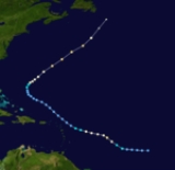
The 1963 Atlantic hurricane season was a below average Atlantic hurricane season
, with nine named storm
s. Although the season officially began on June 1, the first storm did not form until nearly a month later. Hurricane Cindy made landfall
in Texas before dissipating in the southern portion of the state. In late September, Hurricane Edith moved through the Windward Islands
and Greater Antilles
before dissipating east of the Bahamas, before causing ten fatalities, and leaving roughly $47 million (1963 USD) in damage in the Caribbean
. Following Edith was Hurricane Flora, a powerful hurricane that struck Haiti
and Eastern Cuba
in early October. Throughout its lifetime, Flora killed over 7,000 people, making the system the fifth or sixth deadliest Atlantic hurricane of all time. The final hurricane of the season, Ginny, was a tropical cyclone
that affected parts of North Carolina
in the middle of October. Three people were killed as a result of the storm, and damage totals reached $500,000.
The 1963 season as a whole was very destructive, with at least 7,225 fatalities, and $588.8 million in damage. However, not all storms affected land areas. Hurricane Beulah in late August formed east of the Lesser Antilles
and moved north, several hundred miles to the east of Bermuda
. In addition, Tropical Storm Three in the middle of September formed between the United States East Coast and Bermuda before dissipating well northeast of Newfoundland
.
on August 9, and, after reaching its peak of 100 mph (155 km/h) again that night, steadily weakened until it became extratropical on August 11. Arlene caused $300,000 (1963 USD, $ USD) in property damage in Bermuda, but no lives were lost.
moved northeastward, becoming a tropical depression on September 10. It was subtropical in nature, developing with the instability of cool and warm air, and became a tropical storm on September 11. This small storm reached its peak of 60 mph (95 km/h) on September 12, but a cold front to its west caused it to gradually lose tropical characteristics. The storm became extratropical on September 14, and was absorbed by the cold front on September 15.
rapidly developed into a tropical storm on September 16. Cindy reached hurricane strength the next day, but did not strengthen further prior to its landfall on High Island, Texas
. Cindy brought heavy rain to southeast Texas
as it drifted southwestward over the state. The hurricane dissipated on September 20, after causing $12.5 million (1963 USD, $ USD) in damage and three deaths.
developed a tropical depression on September 23, east of the southern Lesser Antilles
. It moved west-northwestward, quickly intensifying to a hurricane on September 24. It crossed through the Windward Islands
on September 25 as a 95 mph (145 km/h) hurricane, but upper level winds weakened it to a minimal hurricane prior to its Dominican Republic
landfall on September 27. The island ripped apart the circulation, and Edith dissipated on September 29. Edith killed ten in Martinique
, injured 50 across the Caribbean
, and caused $47 million (1963 USD, $ USD) in damage. It was a prelude to Hurricane Flora
just days later.
, and passing near Grenada
shortly afterwards. Flora then crossed the Caribbean Sea and strengthened to a Category 4 hurricane, peaking at 140 mph (220 km/h) winds.
Flora struck the southwest peninsula of Haiti on October 4 as a 140 mph (220 km/h) hurricane, causing heavy rains. Flora then hit southeast Cuba near Guantanamo Bay on the same day, but a high pressure system to its north and west caused it to drift over Cuba and nearby waters. During this time, intense driving rains caused catastrophic flooding, resulting in thousands of deaths and millions in crop damage. A shortwave trough
finally pulled Flora to the northeast, bringing the hurricane into the Atlantic Ocean on October 8. Flora strengthened over the open Atlantic, but posed a threat only to shipping, and became extratropical on October 12.
Hurricane Flora was the fifth or sixth deadliest Atlantic hurricane of all time, causing over 7,000 deaths and hundreds of millions of dollars in damage, mostly due to flooding from intense rains as it stalled over Cuba and the surrounding areas. Damage estimates (mostly crop losses) reached over $500 million (1963 USD, $ USD).
reported a cold-core system that day, but as Ginny became better organized, it warmed, becoming a hurricane on October 20 and having an official warm core on October 22. After looping off the coast of North Carolina
and moving southwestward, Ginny weakened to a tropical storm, but as it crossed over the Gulf Stream
again, it restrengthened to a hurricane. Ginny turned to the northeast on October 25, remaining offshore but coming close enough to cause rain and winds. The hurricane's intensity fluctuated as it headed northeastward, reaching its peak of 110 mph (175 km/h) on October 29. Ginny became extratropical due to the cooler waters and cooler air on October 29, just after making landfall on southwest Nova Scotia
.
Ginny was unusual as it is one of the latest hurricanes on record to make landfall near New England
, and was reported to have produced 18 in (457.2 mm) of snow
over Maine
. The hurricane caused a total of seven deaths and $300,000 in damage (1963 USD, $ USD).
. Helena's intensity fluctuated for the next three days, but upper level shear from Ginny and a low pressure surface trough caused it to dissipate on October 29. Though it was weak, Helena was able to cause five deaths and $500,000 (1963 USD, $ USD) in damage.
Atlantic hurricane season
The Atlantic hurricane season is the period in a year when hurricanes usually form in the Atlantic Ocean. Tropical cyclones in the North Atlantic are called hurricanes, tropical storms, or tropical depressions. In addition, there have been several storms over the years that have not been fully...
, with nine named storm
Tropical cyclone naming
Tropical cyclones have officially been named since 1945 and are named for a variety of reasons, which include to facilitate communications between forecasters and the public when forecasts, watches, and warnings are issued. Names also reduce confusion about what storm is being described, as more...
s. Although the season officially began on June 1, the first storm did not form until nearly a month later. Hurricane Cindy made landfall
Landfall (meteorology)
Landfall is the event of a tropical cyclone or a waterspout coming onto land after being over water. When a waterspout makes landfall it is reclassified as a tornado, which can then cause damage inland...
in Texas before dissipating in the southern portion of the state. In late September, Hurricane Edith moved through the Windward Islands
Windward Islands
The Windward Islands are the southern islands of the Lesser Antilles, within the West Indies.-Name and geography:The Windward Islands are called such because they were more windward to sailing ships arriving in the New World than the Leeward Islands, given that the prevailing trade winds in the...
and Greater Antilles
Greater Antilles
The Greater Antilles are one of three island groups in the Caribbean. Comprising Cuba, Jamaica, Hispaniola , and Puerto Rico, the Greater Antilles constitute almost 90% of the land mass of the entire West Indies.-Greater Antilles in context :The islands of the Caribbean Sea, collectively known as...
before dissipating east of the Bahamas, before causing ten fatalities, and leaving roughly $47 million (1963 USD) in damage in the Caribbean
Caribbean Sea
The Caribbean Sea is a sea of the Atlantic Ocean located in the tropics of the Western hemisphere. It is bounded by Mexico and Central America to the west and southwest, to the north by the Greater Antilles, and to the east by the Lesser Antilles....
. Following Edith was Hurricane Flora, a powerful hurricane that struck Haiti
Haiti
Haiti , officially the Republic of Haiti , is a Caribbean country. It occupies the western, smaller portion of the island of Hispaniola, in the Greater Antillean archipelago, which it shares with the Dominican Republic. Ayiti was the indigenous Taíno or Amerindian name for the island...
and Eastern Cuba
Cuba
The Republic of Cuba is an island nation in the Caribbean. The nation of Cuba consists of the main island of Cuba, the Isla de la Juventud, and several archipelagos. Havana is the largest city in Cuba and the country's capital. Santiago de Cuba is the second largest city...
in early October. Throughout its lifetime, Flora killed over 7,000 people, making the system the fifth or sixth deadliest Atlantic hurricane of all time. The final hurricane of the season, Ginny, was a tropical cyclone
Tropical cyclone
A tropical cyclone is a storm system characterized by a large low-pressure center and numerous thunderstorms that produce strong winds and heavy rain. Tropical cyclones strengthen when water evaporated from the ocean is released as the saturated air rises, resulting in condensation of water vapor...
that affected parts of North Carolina
North Carolina
North Carolina is a state located in the southeastern United States. The state borders South Carolina and Georgia to the south, Tennessee to the west and Virginia to the north. North Carolina contains 100 counties. Its capital is Raleigh, and its largest city is Charlotte...
in the middle of October. Three people were killed as a result of the storm, and damage totals reached $500,000.
The 1963 season as a whole was very destructive, with at least 7,225 fatalities, and $588.8 million in damage. However, not all storms affected land areas. Hurricane Beulah in late August formed east of the Lesser Antilles
Lesser Antilles
The Lesser Antilles are a long, partly volcanic island arc in the Western Hemisphere. Most of its islands form the eastern boundary of the Caribbean Sea with the Atlantic Ocean, with the remainder located in the southern Caribbean just north of South America...
and moved north, several hundred miles to the east of Bermuda
Bermuda
Bermuda is a British overseas territory in the North Atlantic Ocean. Located off the east coast of the United States, its nearest landmass is Cape Hatteras, North Carolina, about to the west-northwest. It is about south of Halifax, Nova Scotia, Canada, and northeast of Miami, Florida...
. In addition, Tropical Storm Three in the middle of September formed between the United States East Coast and Bermuda before dissipating well northeast of Newfoundland
Newfoundland and Labrador
Newfoundland and Labrador is the easternmost province of Canada. Situated in the country's Atlantic region, it incorporates the island of Newfoundland and mainland Labrador with a combined area of . As of April 2011, the province's estimated population is 508,400...
.
Hurricane Arlene
A cloud mass in the central Atlantic became a tropical depression on July 31. It headed to the west, becoming a tropical storm on August 2. Arlene rapidly intensified that day to become a 100 mph (155 km/h) Category 2 hurricane, but lack of outflow weakened Arlene to a tropical depression on August 4. For the next three days, a disturbed area of low pressure that may have had a circulation moved to the northwest. On August 8, while turning northeastward, conditions favored development again, and Arlene rapidly intensified to a hurricane that night. Arlene passed over BermudaBermuda
Bermuda is a British overseas territory in the North Atlantic Ocean. Located off the east coast of the United States, its nearest landmass is Cape Hatteras, North Carolina, about to the west-northwest. It is about south of Halifax, Nova Scotia, Canada, and northeast of Miami, Florida...
on August 9, and, after reaching its peak of 100 mph (155 km/h) again that night, steadily weakened until it became extratropical on August 11. Arlene caused $300,000 (1963 USD, $ USD) in property damage in Bermuda, but no lives were lost.
Hurricane Beulah
The precursor to Hurricane Beulah was a tropical wave moving across the tropical Atlantic. It was organized enough to be called a tropical depression on August 20, and it strengthened to tropical storm force the next day. Beulah moved northwestward, becoming a hurricane on August 22 and a major hurricane on August 24. The hurricane turned to the north, where the anticyclone that was favoring development to its south caused unfavorable conditions. Beulah weakened to a minimal hurricane, and raced to the northeast, maintaining hurricane strength until it became extratropical on August 28, 250 mi (402.33 km) east of Newfoundland.Tropical Storm Three
A weak circulation north of Puerto RicoPuerto Rico
Puerto Rico , officially the Commonwealth of Puerto Rico , is an unincorporated territory of the United States, located in the northeastern Caribbean, east of the Dominican Republic and west of both the United States Virgin Islands and the British Virgin Islands.Puerto Rico comprises an...
moved northeastward, becoming a tropical depression on September 10. It was subtropical in nature, developing with the instability of cool and warm air, and became a tropical storm on September 11. This small storm reached its peak of 60 mph (95 km/h) on September 12, but a cold front to its west caused it to gradually lose tropical characteristics. The storm became extratropical on September 14, and was absorbed by the cold front on September 15.
Hurricane Cindy
A trough of low pressure over the Gulf of MexicoGulf of Mexico
The Gulf of Mexico is a partially landlocked ocean basin largely surrounded by the North American continent and the island of Cuba. It is bounded on the northeast, north and northwest by the Gulf Coast of the United States, on the southwest and south by Mexico, and on the southeast by Cuba. In...
rapidly developed into a tropical storm on September 16. Cindy reached hurricane strength the next day, but did not strengthen further prior to its landfall on High Island, Texas
High Island, Texas
High Island is an unincorporated area located in the Bolivar Peninsula census-designated place, Galveston County, Texas, United States. The community is located in the extreme eastern part of the county on Bolivar Peninsula, less than one mile from Chambers County and less than two miles from...
. Cindy brought heavy rain to southeast Texas
Texas
Texas is the second largest U.S. state by both area and population, and the largest state by area in the contiguous United States.The name, based on the Caddo word "Tejas" meaning "friends" or "allies", was applied by the Spanish to the Caddo themselves and to the region of their settlement in...
as it drifted southwestward over the state. The hurricane dissipated on September 20, after causing $12.5 million (1963 USD, $ USD) in damage and three deaths.
Hurricane Debra
On September 19, a westward moving tropical wave became a tropical depression in the central tropical Atlantic. It became a tropical storm on September 21, and spared the islands as it turned northward. Debra became a hurricane on September 21, but as it moved northward, it was gradually absorbed by a large extratropical storm. Debra dissipated on September 24.Hurricane Edith
The Intertropical Convergence ZoneIntertropical Convergence Zone
The Intertropical Convergence Zone , known by sailors as The Doldrums, is the area encircling the earth near the equator where winds originating in the northern and southern hemispheres come together....
developed a tropical depression on September 23, east of the southern Lesser Antilles
Lesser Antilles
The Lesser Antilles are a long, partly volcanic island arc in the Western Hemisphere. Most of its islands form the eastern boundary of the Caribbean Sea with the Atlantic Ocean, with the remainder located in the southern Caribbean just north of South America...
. It moved west-northwestward, quickly intensifying to a hurricane on September 24. It crossed through the Windward Islands
Windward Islands
The Windward Islands are the southern islands of the Lesser Antilles, within the West Indies.-Name and geography:The Windward Islands are called such because they were more windward to sailing ships arriving in the New World than the Leeward Islands, given that the prevailing trade winds in the...
on September 25 as a 95 mph (145 km/h) hurricane, but upper level winds weakened it to a minimal hurricane prior to its Dominican Republic
Dominican Republic
The Dominican Republic is a nation on the island of La Hispaniola, part of the Greater Antilles archipelago in the Caribbean region. The western third of the island is occupied by the nation of Haiti, making Hispaniola one of two Caribbean islands that are shared by two countries...
landfall on September 27. The island ripped apart the circulation, and Edith dissipated on September 29. Edith killed ten in Martinique
Martinique
Martinique is an island in the eastern Caribbean Sea, with a land area of . Like Guadeloupe, it is an overseas region of France, consisting of a single overseas department. To the northwest lies Dominica, to the south St Lucia, and to the southeast Barbados...
, injured 50 across the Caribbean
Caribbean
The Caribbean is a crescent-shaped group of islands more than 2,000 miles long separating the Gulf of Mexico and the Caribbean Sea, to the west and south, from the Atlantic Ocean, to the east and north...
, and caused $47 million (1963 USD, $ USD) in damage. It was a prelude to Hurricane Flora
Hurricane Flora
Hurricane Flora is among the deadliest Atlantic hurricanes in recorded history, with a death total of over 7,000. The seventh tropical storm and sixth hurricane of the 1963 Atlantic hurricane season, Flora developed from a disturbance in the Intertropical Convergence Zone on September 26 while...
just days later.
Hurricane Flora
Hurricane Flora originated from a tropical depression which formed on September 26 in the Central Atlantic. The depression moved rapidly west-northwestward, and on September 29 it reached tropical storm status. It then rapidly intensified into a 120 mph (195 km/h) Category 3 hurricane by September 30. Flora moved through the Leeward Islands, first striking the island of TobagoTobago
Tobago is the smaller of the two main islands that make up the Republic of Trinidad and Tobago. It is located in the southern Caribbean, northeast of the island of Trinidad and southeast of Grenada. The island lies outside the hurricane belt...
, and passing near Grenada
Grenada
Grenada is an island country and Commonwealth Realm consisting of the island of Grenada and six smaller islands at the southern end of the Grenadines in the southeastern Caribbean Sea...
shortly afterwards. Flora then crossed the Caribbean Sea and strengthened to a Category 4 hurricane, peaking at 140 mph (220 km/h) winds.
Flora struck the southwest peninsula of Haiti on October 4 as a 140 mph (220 km/h) hurricane, causing heavy rains. Flora then hit southeast Cuba near Guantanamo Bay on the same day, but a high pressure system to its north and west caused it to drift over Cuba and nearby waters. During this time, intense driving rains caused catastrophic flooding, resulting in thousands of deaths and millions in crop damage. A shortwave trough
Shortwave (meteorology)
A shortwave or shortwave trough is an embedded kink in the trough / ridge pattern. This is the opposite of longwaves, which are responsible for synoptic scale systems, although shortwaves may be contained within or found ahead of longwaves and range from the mesocale to the synoptic scale...
finally pulled Flora to the northeast, bringing the hurricane into the Atlantic Ocean on October 8. Flora strengthened over the open Atlantic, but posed a threat only to shipping, and became extratropical on October 12.
Hurricane Flora was the fifth or sixth deadliest Atlantic hurricane of all time, causing over 7,000 deaths and hundreds of millions of dollars in damage, mostly due to flooding from intense rains as it stalled over Cuba and the surrounding areas. Damage estimates (mostly crop losses) reached over $500 million (1963 USD, $ USD).
Hurricane Ginny
A cold-core trough of low pressure existed over the Bahamas, leading to the development of a depression on October 16. The depression moved northward, reaching tropical storm force winds on October 19. Reconnaissance aircraftReconnaissance aircraft
A reconnaissance aircraft is a manned military aircraft designed, or adapted, to carry out aerial reconnaissance.-History:The majority of World War I aircraft were reconnaissance designs...
reported a cold-core system that day, but as Ginny became better organized, it warmed, becoming a hurricane on October 20 and having an official warm core on October 22. After looping off the coast of North Carolina
North Carolina
North Carolina is a state located in the southeastern United States. The state borders South Carolina and Georgia to the south, Tennessee to the west and Virginia to the north. North Carolina contains 100 counties. Its capital is Raleigh, and its largest city is Charlotte...
and moving southwestward, Ginny weakened to a tropical storm, but as it crossed over the Gulf Stream
Gulf Stream
The Gulf Stream, together with its northern extension towards Europe, the North Atlantic Drift, is a powerful, warm, and swift Atlantic ocean current that originates at the tip of Florida, and follows the eastern coastlines of the United States and Newfoundland before crossing the Atlantic Ocean...
again, it restrengthened to a hurricane. Ginny turned to the northeast on October 25, remaining offshore but coming close enough to cause rain and winds. The hurricane's intensity fluctuated as it headed northeastward, reaching its peak of 110 mph (175 km/h) on October 29. Ginny became extratropical due to the cooler waters and cooler air on October 29, just after making landfall on southwest Nova Scotia
Nova Scotia
Nova Scotia is one of Canada's three Maritime provinces and is the most populous province in Atlantic Canada. The name of the province is Latin for "New Scotland," but "Nova Scotia" is the recognized, English-language name of the province. The provincial capital is Halifax. Nova Scotia is the...
.
Ginny was unusual as it is one of the latest hurricanes on record to make landfall near New England
New England
New England is a region in the northeastern corner of the United States consisting of the six states of Maine, New Hampshire, Vermont, Massachusetts, Rhode Island, and Connecticut...
, and was reported to have produced 18 in (457.2 mm) of snow
Snow
Snow is a form of precipitation within the Earth's atmosphere in the form of crystalline water ice, consisting of a multitude of snowflakes that fall from clouds. Since snow is composed of small ice particles, it is a granular material. It has an open and therefore soft structure, unless packed by...
over Maine
Maine
Maine is a state in the New England region of the northeastern United States, bordered by the Atlantic Ocean to the east and south, New Hampshire to the west, and the Canadian provinces of Quebec to the northwest and New Brunswick to the northeast. Maine is both the northernmost and easternmost...
. The hurricane caused a total of seven deaths and $300,000 in damage (1963 USD, $ USD).
Tropical Storm Helena
Tropical Storm Helena formed from an easterly wave on October 25. It became a tropical storm that day, and reached its peak of 50 mph (85 km/h) before hitting the Lesser AntillesLesser Antilles
The Lesser Antilles are a long, partly volcanic island arc in the Western Hemisphere. Most of its islands form the eastern boundary of the Caribbean Sea with the Atlantic Ocean, with the remainder located in the southern Caribbean just north of South America...
. Helena's intensity fluctuated for the next three days, but upper level shear from Ginny and a low pressure surface trough caused it to dissipate on October 29. Though it was weak, Helena was able to cause five deaths and $500,000 (1963 USD, $ USD) in damage.
Storm names
The following names were used for named storms (tropical storms and hurricanes) that formed in the North Atlantic in 1963. Storms were named Ginny and Helena for the first time in 1963. Names that were not assigned are marked in .
|
|
Retirement
The name Flora was later retired.See also
- List of Atlantic hurricanes
- List of Atlantic hurricane seasons