

List of South America tropical cyclones
Encyclopedia
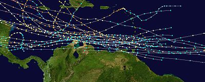
A South American cyclone is a tropical cyclone
Tropical cyclone
A tropical cyclone is a storm system characterized by a large low-pressure center and numerous thunderstorms that produce strong winds and heavy rain. Tropical cyclones strengthen when water evaporated from the ocean is released as the saturated air rises, resulting in condensation of water vapor...
that affects the continent of South America or its countries. The continent is rarely affected by tropical cyclones, though most storms to hit the area formed in the North Atlantic Ocean
Atlantic Ocean
The Atlantic Ocean is the second-largest of the world's oceanic divisions. With a total area of about , it covers approximately 20% of the Earth's surface and about 26% of its water surface area...
.
Venezuela
Venezuela , officially called the Bolivarian Republic of Venezuela , is a tropical country on the northern coast of South America. It borders Colombia to the west, Guyana to the east, and Brazil to the south...
and Colombia
Colombia
Colombia, officially the Republic of Colombia , is a unitary constitutional republic comprising thirty-two departments. The country is located in northwestern South America, bordered to the east by Venezuela and Brazil; to the south by Ecuador and Peru; to the north by the Caribbean Sea; to the...
have a 1 to 5% chance of a hurricane strike in any given year, while all locations south of 10° N have less than a 1% chance of a direct hit. A total of 38 tropical cyclones have affected the continent since 1588.
Storms in the South Atlantic
The South Atlantic Ocean is generally inhospitable to the formation of a tropical storm. Although rare, a growing number of subtropical cyclones have developed in the South Atlantic Ocean near BrazilBrazil
Brazil , officially the Federative Republic of Brazil , is the largest country in South America. It is the world's fifth largest country, both by geographical area and by population with over 192 million people...
, such as the unofficially-named Cyclone Catarina
Cyclone Catarina
Cyclone Catarina is one of several informal names for a South Atlantic tropical cyclone that hit southeastern Brazil in late March 2004. The storm developed out of a stationary cold-core upper-level trough on March 12...
of 2004 that made landfall as a Category 2. Since 2011, certain storms have official names, such as Subtropical Storm Arani
Subtropical Storm Arani
Subtropical Cyclone Arani was a subtropical cyclone that existed in March 2011 in the South Atlantic. Arani was the ninth recorded storm in South Atlantic history, fourth subtropical cyclone, third named storm, and first officially named subtropical storm....
. At least one storm has formed near the West Coast of Africa.
Pre-1900
- November 4–6, 1588 - Cartagena de Indias in ColombiaColombiaColombia, officially the Republic of Colombia , is a unitary constitutional republic comprising thirty-two departments. The country is located in northwestern South America, bordered to the east by Venezuela and Brazil; to the south by Ecuador and Peru; to the north by the Caribbean Sea; to the...
is affected by a hurricane. - September, 1672 - A hurricane affects CaracasCaracasCaracas , officially Santiago de León de Caracas, is the capital and largest city of Venezuela; natives or residents are known as Caraquenians in English . It is located in the northern part of the country, following the contours of the narrow Caracas Valley on the Venezuelan coastal mountain range...
, VenezuelaVenezuelaVenezuela , officially called the Bolivarian Republic of Venezuela , is a tropical country on the northern coast of South America. It borders Colombia to the west, Guyana to the east, and Brazil to the south...
. - October 22, 1683 - The island of CuraçaoCuraçaoCuraçao is an island in the southern Caribbean Sea, off the Venezuelan coast. The Country of Curaçao , which includes the main island plus the small, uninhabited island of Klein Curaçao , is a constituent country of the Kingdom of the Netherlands...
off Venezuela is impacted by a hurricane. - September, 1773 - A hurricane moves across Venezuela and later Colombia.
- December 13–22, 1822 - A hurricane traverses the southeastern Caribbean SeaCaribbean SeaThe Caribbean Sea is a sea of the Atlantic Ocean located in the tropics of the Western hemisphere. It is bounded by Mexico and Central America to the west and southwest, to the north by the Greater Antilles, and to the east by the Lesser Antilles....
and makes landfall on Venezuela. - October 13, 1847 - Venezuela is affected by a hurricane.
Saffir-Simpson Hurricane Scale
The Saffir–Simpson Hurricane Scale , or the Saffir–Simpson Hurricane Wind Scale , classifies hurricanes — Western Hemisphere tropical cyclones that exceed the intensities of tropical depressions and tropical storms — into five categories distinguished by the intensities of their sustained winds...
hurricane makes landfall on northern Venezuela, causing winds of up to 80 mph in Curaçao
Curaçao
Curaçao is an island in the southern Caribbean Sea, off the Venezuelan coast. The Country of Curaçao , which includes the main island plus the small, uninhabited island of Klein Curaçao , is a constituent country of the Kingdom of the Netherlands...
.
1900s
.jpg)
- September 5, 1911 - CuraçaoCuraçaoCuraçao is an island in the southern Caribbean Sea, off the Venezuelan coast. The Country of Curaçao , which includes the main island plus the small, uninhabited island of Klein Curaçao , is a constituent country of the Kingdom of the Netherlands...
experiences a westward moving tropical storm which passes near the northern coasts of VenezuelaVenezuelaVenezuela , officially called the Bolivarian Republic of Venezuela , is a tropical country on the northern coast of South America. It borders Colombia to the west, Guyana to the east, and Brazil to the south...
and ColombiaColombiaColombia, officially the Republic of Colombia , is a unitary constitutional republic comprising thirty-two departments. The country is located in northwestern South America, bordered to the east by Venezuela and Brazil; to the south by Ecuador and Peru; to the north by the Caribbean Sea; to the...
. - November 2–5, 1932 - A Category 2 hurricane parallels the north coast of Venezuela and Colombia 75 miles (120 km) offshore, causing some damage. Later, it passes to the northeast of Providencia IslandProvidencia IslandIsla de Providencia or Old Providence is a mountainous Caribbean island. Though it is closer to Nicaragua, it is part of the Archipelago of San Andres, Providencia and Santa Catalina, a department of Colombia, lying midway between Costa Rica and Jamaica...
, destroying 36 houses and ruining crops. - June 27, 1933 - A minimal hurricane moves through northeastern Venezuela. The hurricane destroys several houses, businesses, and fishing boats. Powerful winds cut telephonic and telegraphic communications for several days. The hurricane killed several people, and caused over $200,000 in damage (1933 USD, $3.3 million 2008 USD).
- October 8, 1954 - Hurricane HazelHurricane HazelHurricane Hazel was the deadliest and costliest hurricane of the 1954 Atlantic hurricane season. The storm killed as many as 1,000 people in Haiti before striking the United States near the border between North and South Carolina, as a Category 4 hurricane...
parallels the north coasts of Venezuela and Colombia around 100 miles (160 km) offshore as a Category 3 hurricane, though effects, if any, are unknown. - September 25, 1955 - Hurricane JanetHurricane JanetHurricane Janet was the most powerful hurricane of the 1955 Atlantic hurricane season and one of the strongest Atlantic hurricanes on record. It made landfall as a Category 5 hurricane on the Saffir-Simpson Hurricane Scale, causing catastrophic damage and at least 687 deaths in the Lesser...
parallels the north coasts of Venezuela and Colombia around 100 miles (160 km) offshore as a Category 4 hurricane, though effects, if any, are unknown. - July 20, 1961 - Hurricane Anna passes 75 miles (120 km) north of the coast of Venezuela, though effects, if any, are unknown.
- October 28, 1961 - Hurricane HattieHurricane HattieHurricane Hattie was the deadliest tropical cyclone of the 1961 Atlantic hurricane season, as well as the strongest, reaching a peak intensity equivalent to Category 5 hurricane intensity...
moves over San Andrés islandSan Andrés (island)San Andrés is a coral island among the Colombian islands in the Caribbean Sea; it is the largest island of the southern group of islands. Together with the nearby island of Providencia and some smaller islands of the southern group of the Colombian archipelago, San Andrés forms the department of...
with winds of 80 mph (130 km/h), causing 1 death, 15 injuries, and $300,000 in damage (1961 USD, $2.1 million 2008 USD). - October 1, 1963 - Hurricane FloraHurricane FloraHurricane Flora is among the deadliest Atlantic hurricanes in recorded history, with a death total of over 7,000. The seventh tropical storm and sixth hurricane of the 1963 Atlantic hurricane season, Flora developed from a disturbance in the Intertropical Convergence Zone on September 26 while...
strikes TobagoTobagoTobago is the smaller of the two main islands that make up the Republic of Trinidad and Tobago. It is located in the southern Caribbean, northeast of the island of Trinidad and southeast of Grenada. The island lies outside the hurricane belt...
and remains just offshore of Venezuela as it moves through the Caribbean Sea as a Category 3 hurricane. Damage in Venezuela, if any, is unknown. - September 7, 1971 - A tropical depression intensifies into Tropical Storm EdithHurricane EdithHurricane Edith was the strongest hurricane to form during the 1971 Atlantic hurricane season. It developed from a tropical wave on September 5 and quickly strengthened into a hurricane in the Caribbean Sea. Edith rapidly intensified on September 9 and made landfall on Cape Gracias a Dios as a...
near the north coast of Venezuela. The southern portion of the depression's circulation moves over the northeastern portion of the country. Effects are unknown. - September 16, 1971 - A tropical depression that later becomes Hurricane Irene crosses the island of Curaçao. Effects are unknown.
- August 14, 1974 - Tropical Storm Alma makes landfall on northeastern Venezuela and later dissipates over the mountainous country. Intense rain bands cause a passenger plane to crash on Isla MargaritaIsla MargaritaMargarita Island is the largest island of the state of Nueva Esparta in Venezuela, situated in the Caribbean Sea, off the northeastern coast of the country. The state also contains two other smaller islands: Coche and Cubagua. The capital city of Nueva Esparta is La Asunción, located in a river...
, resulting in 47 indirect deaths. Damage is unknown. - August 12, 1978 - Tropical Depression Cora dissipates near the island of Curaçao, causing no known impact.
- September 13, 1978 - A tropical depression that later becomes Hurricane GretaHurricane Greta-OliviaHurricane Greta–Olivia was a Category 4 hurricane that crossed over Central America, changing names upon reaching the Eastern Pacific during the 1978 Atlantic hurricane season and 1978 Pacific hurricane season. Striking Honduras on the fourth anniversary of Hurricane Fifi, the Greta threatened to...
forms near the northeastern coast of Venezuela, causing no known damage. - September 10–12, 1988 - Outflow bands from Hurricane GilbertHurricane GilbertHurricane Gilbert was an extremely powerful Cape Verde-type hurricane that formed during the 1988 Atlantic hurricane season and created widespread destruction in the Caribbean Sea and the Gulf of Mexico. It is the second most intense hurricane ever observed in the Atlantic basin behind only...
produce flash flooding in northern Venezuela. The flooding killed five people. - October 16–18, 1988 - Tropical Storm JoanHurricane Joan-MiriamHurricane Joan was a powerful hurricane that caused death and destruction in over a dozen countries in the Caribbean and Central America. Moving on a due west course for nearly two weeks in October 1988, Hurricane Joan caused widespread flooding and over 200 deaths after moving into Central America...
strikes northern Venezuela and Colombia. The storm produces flash flooding which kills 11 in Venezuela. In Colombia, rainfall from Joan kills 25, and leaves 27,000 homeless. - August 14, 1990 - Minimal Tropical Storm Fran dissipates over northeastern Venezuela, with no known impact.
- August 7–9, 1993 - Tropical Storm BretTropical Storm Bret (1993)Tropical Storm Bret was the second named storm of the 1993 Atlantic hurricane season. The third tropical cyclone of the season, Bret formed on August 4 from a westward moving, African tropical wave. Bret would later peak as a 60 mph tropical storm as it neared Trinidad...
moves across northern Venezuela and Colombia. In Venezuela, the storm drops at least 13.35 inches (339 mm) in GuanareGuanareGuanare is the capital city of Portuguesa State, Venezuela. It is where la Virgen de Coromoto is said to have appeared to a Coromoto Indian.Located at the edge of the Southwestern floodplains, near the Andes foothills, Guanare is in a region known for livestock and agricultural production...
. The rainfall causes mudslides, particularly near the city of Caracas, that cover many low-income housing units. Of the 173 deaths caused by Bret in Venezuela, most occur in the low-income areas near Caracas. Lack of preparation, including weather forecasters prematurely stating the worst of the storm is over, is part of the problem. In all, 10,000 are left homeless, and damaged totals $25 million (1993 USD, $37 million 2008 USD). In Colombia, Bret causes one death and one injury. - July 24–27, 1996 - Hurricane CesarHurricane Cesar-DouglasHurricane Cesar–Douglas was a devastating tropical cyclone that killed 122 people throughout Central and South America in late-July 1996. The Category 1 hurricane formed in late July in the Caribbean Sea and pounded Central America with rain, killing 67 people and causing local governments to deem...
moves westward across the southern Caribbean SeaCaribbean SeaThe Caribbean Sea is a sea of the Atlantic Ocean located in the tropics of the Western hemisphere. It is bounded by Mexico and Central America to the west and southwest, to the north by the Greater Antilles, and to the east by the Lesser Antilles....
and crosses over extreme northern Colombia and the San Andrés archipelago. Cesar kills 11 people in Colombia due to flooding and mudslides. - November 13–16, 1999 - Strong waves from Hurricane LennyHurricane LennyHurricane Lenny was the strongest November Atlantic hurricane on record. It was the twelfth tropical storm, eighth hurricane, and record-breaking fifth Category 4 hurricane in the 1999 Atlantic hurricane season. Lenny formed on November 13 in the western Caribbean Sea, and maintained an...
effect the Guajira PeninsulaGuajira PeninsulaGuajira Peninsula , is a peninsula in northern Colombia and northwestern Venezuela in the Caribbean Sea...
of Colombia, flooding 1,200 homes and businesses along the northern coastline. In addition, winds and rains from the hurricane causes severe crop damage in the country. The hurricane kills two in Colombia.
2000s
- September 25, 2000 - Hurricane Joyce dissipates just north of eastern VenezuelaVenezuelaVenezuela , officially called the Bolivarian Republic of Venezuela , is a tropical country on the northern coast of South America. It borders Colombia to the west, Guyana to the east, and Brazil to the south...
, causing no known damage. - September 14, 2002 - Hurricane IsidoreHurricane IsidoreHurricane Isidore was the ninth named storm and the second hurricane in the 2002 Atlantic hurricane season. Isidore was the fifth of eight named storms to occur in September. The tropical cyclone peaked as a Category 3 hurricane, causing damage as well as four fatalities in Jamaica, Cuba, Mexico,...
crosses over northeastern Venezuela as a tropical depression. Effects, if any, are unknown. - December 4, 2003 - Tropical Storm OdetteTropical Storm Odette (2003)Tropical Storm Odette was a rare off-season tropical storm that affected the Caribbean Sea in December 2003. The 15th tropical storm of the 2003 Atlantic hurricane season, Odette formed near the coast of Panama a few days after the official end of the Atlantic hurricane season, and ultimately made...
produces heavy rainfall of up to 8 inches (200 mm) in ColombiaColombiaColombia, officially the Republic of Colombia , is a unitary constitutional republic comprising thirty-two departments. The country is located in northwestern South America, bordered to the east by Venezuela and Brazil; to the south by Ecuador and Peru; to the north by the Caribbean Sea; to the...
. - January 20, 2004 - A possible tropical storm or depression in the South Atlantic Ocean hits eastern BrazilBrazilBrazil , officially the Federative Republic of Brazil , is the largest country in South America. It is the world's fifth largest country, both by geographical area and by population with over 192 million people...
, dropping heavy rainfall in the area. - March 28, 2004 - A cyclone, unofficially named Cyclone CatarinaCyclone CatarinaCyclone Catarina is one of several informal names for a South Atlantic tropical cyclone that hit southeastern Brazil in late March 2004. The storm developed out of a stationary cold-core upper-level trough on March 12...
, strikes southeastern Brazil with maximum recorded winds of 90 mph (145 km/h). The hurricane damaged more than 30,000 homes and left 1,900 people homeless. The storm also damaged 1,373 businesses and destroyed 50, including a hospital. The storm killed 3, injured 38, and caused up to $330 million in damage (2004 USD). - September 7–9, 2004 - Hurricane IvanHurricane IvanHurricane Ivan was a large, long-lived, Cape Verde-type hurricane that caused widespread damage in the Caribbean and United States. The cyclone was the ninth named storm, the sixth hurricane and the fourth major hurricane of the active 2004 Atlantic hurricane season...
parallels the north coast of Venezuela as a Category 4 hurricane. Ivan's strong winds forced the closure of several airports. The hurricane also produced heavy rainfall and strong waves. Ivan killed three in the country, though overall damage was minor. - July 14, 2005 - Hurricane EmilyHurricane Emily (2005)Hurricane Emily was a powerful, early season tropical cyclone that caused significant damage across the Caribbean Sea to Mexico. A Cape Verde-type hurricane, the storm formed on July 10, 2005, in the central Atlantic Ocean before passing through the Windward Islands on July 14...
passes just north of Venezuela as a strengthening hurricane, causing heavy rains and flooding in the northeastern portion of the country. 64 families were forced to leave their homes when rivers in eastern MonagasMonagasMonagas State is one of the 23 states of Venezuela.Monagas State covers a total surface area of 28,900 km² and, in June 30, 2010, had an estimated population of 908,626....
state overflowed their banks, but waters quickly receded. Ships were forced to remain at port while the hurricane passed to the country's north, though restrictions quickly lifted. - October 29, 2005 - Hurricane BetaHurricane Beta (2005)Hurricane Beta was a compact and intense tropical cyclone that impacted areas around the southwestern Caribbean Sea in late October 2005. Beta was the twenty-fourth tropical or subtropical storm, fourteenth hurricane, and seventh and final major hurricane of the record-breaking 2005 Atlantic...
hits the Colombian island of ProvidenciaProvidenciaProvidencia may refer to:* Providencia, Chile* Providencia District in Amazonas, Peru* Providencia Island, part of the San Andrés y Providencia Department district of Colombia in the Caribbean sea...
, and tears the roofs off of thousands of homes. High winds also shut down all airports and communications. - September 2, 2007 - Strong winds and waves from Hurricane Felix leave one person missing in the coastal city of Puerto CabelloPuerto CabelloPuerto Cabello is a city on the north coast of Venezuela. It is located in Carabobo State about 75 km west of Caracas. As of 2001, the city has a population of around 154,000 people. The city is the home to the largest port in the country and is thus a vital cog in the country's vast oil...
. - January 28, 2009 - A cold-core mid to upper-level trough in phase with a low-level warm-core low formed a system over Uruguay and Rio Grande do Sul state in Brazil and moved eastward into the South Atlantic. The system was eventually classified as a subtropical cyclone, making it the only subtropical cyclone on record to effect South America, and the second subtropical system ever recorded in the South Atlantic, with the first being a subtropical cyclone in 1974. Winds exceeded 54 kts on the coast of Uruguay and extreme southern Rio Grande do Sul, and the system produced 300 mm of rainfall or more in 24 hours in some locations of Rocha (Uruguay) and southern Rio Grande do Sul. Fourteen deaths and thousands of evacuees are attributed to the storm with an emergency declared in four cities.
- March 10, 2010 - Unofficially named (by private and public weather centers from Southern Brazil) Tropical Storm Anita (90Q)Tropical Storm Anita (2010)Tropical Storm Anita was the second tropical cyclone in the Southern Atlantic Ocean on record, following Cyclone Catarina in March 2004. Originating from an extratropical cyclone over southern Brazil, this system quickly moved offshore, entering a region favoring subtropical development...
affected the coast of southern Brazil. The cyclone develops out of a subtropical cyclone and is one of the rare tropical cyclones developed in South Atlantic Ocean waters. - Tropical Storm Tomas brings heavy rains to Curacao and South America.
Listed by month
39 tropical cyclones have affected South America in most months of the year.| Month | Number of recorded storms affecting South America |
|---|---|
| January | 2 |
| February | 0 |
| March | 1 |
| April | 0 |
| May | 0 |
| June | 1 |
| July | 3 |
| August | 4 |
| September | 14 |
| October | 8 |
| November | 3 |
| December | 3 |
Deadliest storms
Data from South American tropical cyclones is sparse and incomplete, though most tropical cyclones that struck the continent caused multiple deaths. Bret, Joan, Cesar, Gilbert, Catarina, and Ivan all caused their deaths through rainfall or flash flooding.| Name | Year | Number of deaths |
|---|---|---|
| Subtropical Cyclone of January 2009 | 2009 | 14 |
| Bret | 1993 | 174 |
| Joan | 1988 | 36 |
| Cesar | 1996 | 11 |
| Gilbert | 1988 | 5 |
| Catarina | 2004 | 3 |
| Ivan | 2004 | 3 |
| Lenny | 1999 | 2 |
| Hattie | 1961 | 1 |
| Unnamed | 1933 | "Several" |
| Alma | 1974 | 0 (47 indirect) |
Tropical cyclone warnings and watches
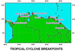
National Hurricane Center
The National Hurricane Center , located at Florida International University in Miami, Florida, is the division of the National Weather Service responsible for tracking and predicting weather systems within the tropics between the Prime Meridian and the 140th meridian west poleward to the 30th...
defines nine locations as tropical cyclone warning breakpoints
Tropical cyclone warnings and watches
Warnings and watches are two levels of alert issued by national weather forecasting bodies to coastal areas threatened by the imminent approach of a tropical cyclone of tropical storm or hurricane intensity. They are notices to the local population and civil authorities to make appropriate...
. The westernmost is the border between Panama
Panama
Panama , officially the Republic of Panama , is the southernmost country of Central America. Situated on the isthmus connecting North and South America, it is bordered by Costa Rica to the northwest, Colombia to the southeast, the Caribbean Sea to the north and the Pacific Ocean to the south. The...
and Colombia
Colombia
Colombia, officially the Republic of Colombia , is a unitary constitutional republic comprising thirty-two departments. The country is located in northwestern South America, bordered to the east by Venezuela and Brazil; to the south by Ecuador and Peru; to the north by the Caribbean Sea; to the...
, and the easternmost is Georgetown, Guyana
Georgetown, Guyana
Georgetown, estimated population 239,227 , is the capital and largest city of Guyana, located in the Demerara-Mahaica region. It is situated on the Atlantic Ocean coast at the mouth of the Demerara River and it was nicknamed 'Garden City of the Caribbean.' Georgetown is located at . The city serves...
, located at 6.82° N. In the eastern Pacific Ocean
Pacific Ocean
The Pacific Ocean is the largest of the Earth's oceanic divisions. It extends from the Arctic in the north to the Southern Ocean in the south, bounded by Asia and Australia in the west, and the Americas in the east.At 165.2 million square kilometres in area, this largest division of the World...
, tropical cyclone warning breakpoints extend eastward to the border of Panama and Colombia at 7.23° N. No Atlantic hurricane has existed south of 6.82° N, and no Pacific hurricane
Pacific hurricane
A Pacific hurricane or tropical storm is a tropical cyclone that develops in the northeastern part of the Pacific Ocean. For organizational purposes, the northern Pacific Ocean is divided into three regions: the eastern, , central , and western...
has existed east of 80° W, though in the event a tropical cyclone threatens a region of South America without warnings, additional warning sites can be selected. In addition to warnings on the mainland of South America, the National Hurricane Center defines the entire island of San Andres as a tropical cyclone warning breakpoint.
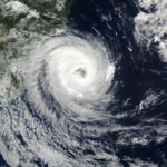
Intense Hurricane Flora
Hurricane Flora
Hurricane Flora is among the deadliest Atlantic hurricanes in recorded history, with a death total of over 7,000. The seventh tropical storm and sixth hurricane of the 1963 Atlantic hurricane season, Flora developed from a disturbance in the Intertropical Convergence Zone on September 26 while...
in 1963 prompted officials to declare gale warnings for two islands off the north coast of Venezuela. In 1974, the passage of Tropical Storm Alma warranted the issuance of Gale Warnings for the Paria
Paria Peninsula
Paria Peninsula is a large peninsula in Sucre State, northern Venezuela. It separates the Gulf of Paria and Caribbean Sea. Península de Paria National Park is located on the peninsula...
and Paraguaná Peninsula
Paraguaná Peninsula
The Paraguaná Peninsula is a peninsula in Venezuela, situated in the north of Falcón State. The island of Aruba lies 27 km to the north. Bonaire and Curaçao are slightly further away. The Paraguaná Peninsula is connected to the rest of the state by a natural isthmus of Médanos. The Peninsula...
s. Hurricane Joan in 1988, Tropical Storm Bret
Tropical Storm Bret (1993)
Tropical Storm Bret was the second named storm of the 1993 Atlantic hurricane season. The third tropical cyclone of the season, Bret formed on August 4 from a westward moving, African tropical wave. Bret would later peak as a 60 mph tropical storm as it neared Trinidad...
in 1993, Hurricane Cesar
Hurricane Cesar-Douglas
Hurricane Cesar–Douglas was a devastating tropical cyclone that killed 122 people throughout Central and South America in late-July 1996. The Category 1 hurricane formed in late July in the Caribbean Sea and pounded Central America with rain, killing 67 people and causing local governments to deem...
in 1996, and Hurricane Felix in 2007 resulted in tropical storm and hurricane watches and warnings for several locations in South America. The threat of Hurricane Ivan
Hurricane Ivan
Hurricane Ivan was a large, long-lived, Cape Verde-type hurricane that caused widespread damage in the Caribbean and United States. The cyclone was the ninth named storm, the sixth hurricane and the fourth major hurricane of the active 2004 Atlantic hurricane season...
prompted a hurricane watch and a tropical storm warning for the northern coast of Venezuela.
See also
- List of Atlantic hurricane seasons
- List of Atlantic hurricanes
- Tropical cycloneTropical cycloneA tropical cyclone is a storm system characterized by a large low-pressure center and numerous thunderstorms that produce strong winds and heavy rain. Tropical cyclones strengthen when water evaporated from the ocean is released as the saturated air rises, resulting in condensation of water vapor...
- Effects of Hurricane Ivan in the Lesser Antilles and South AmericaEffects of Hurricane Ivan in the Lesser Antilles and South AmericaThe effects of Hurricane Ivan in the Lesser Antilles and South America included 44 deaths and over $1 billion in damage , primarily in Grenada where it was considered the worst hurricane in nearly 50 years...