
.gif)
Channel (geography)
Encyclopedia
Physical geography
Physical geography is one of the two major subfields of geography. Physical geography is that branch of natural science which deals with the study of processes and patterns in the natural environment like the atmosphere, biosphere and geosphere, as opposed to the cultural or built environment, the...
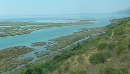
, a channel is the physical confine of a river
Stream channel
Stream channel is the physical confine of a stream consisting of a bed and stream banks.Stream channels exist in a variety of geometries. The stream channel development is controlled by both water and sediment movement. There is a difference between low gradient streams and high gradient streams...
, slough
River delta
A delta is a landform that is formed at the mouth of a river where that river flows into an ocean, sea, estuary, lake, reservoir, flat arid area, or another river. Deltas are formed from the deposition of the sediment carried by the river as the flow leaves the mouth of the river...
or ocean strait
Strait
A strait or straits is a narrow, typically navigable channel of water that connects two larger, navigable bodies of water. It most commonly refers to a channel of water that lies between two land masses, but it may also refer to a navigable channel through a body of water that is otherwise not...
consisting of a bed and banks.
A channel is also the natural or human-made deeper course through a reef
Reef
In nautical terminology, a reef is a rock, sandbar, or other feature lying beneath the surface of the water ....
, sand bar
Bar (landform)
A shoal, sandbar , or gravelbar is a somewhat linear landform within or extending into a body of water, typically composed of sand, silt or small pebbles. A spit or sandspit is a type of shoal...
, bay
Bay
A bay is an area of water mostly surrounded by land. Bays generally have calmer waters than the surrounding sea, due to the surrounding land blocking some waves and often reducing winds. Bays also exist as an inlet in a lake or pond. A large bay may be called a gulf, a sea, a sound, or a bight...
, or any shallow body of water. It is especially used as a Nautical term to mean the dredged and mar (See: Buoy
Buoy
A buoy is a floating device that can have many different purposes. It can be anchored or allowed to drift. The word, of Old French or Middle Dutch origin, is now most commonly in UK English, although some orthoepists have traditionally prescribed the pronunciation...
) lane of safe travel which a cognizant governmental entity guarantees to have a minimum depth across its specified minimum width to all vessels
Ship
Since the end of the age of sail a ship has been any large buoyant marine vessel. Ships are generally distinguished from boats based on size and cargo or passenger capacity. Ships are used on lakes, seas, and rivers for a variety of activities, such as the transport of people or goods, fishing,...
transiting a body of water. The term not only includes the deep-dredged
Dredge
Dredging is an excavation activity or operation usually carried out at least partly underwater, in shallow seas or fresh water areas with the purpose of gathering up bottom sediments and disposing of them at a different location...
ship-navigable parts of an estuary
Estuary
An estuary is a partly enclosed coastal body of water with one or more rivers or streams flowing into it, and with a free connection to the open sea....
or river leading to port
Port
A port is a location on a coast or shore containing one or more harbors where ships can dock and transfer people or cargo to or from land....
facilities, but also to lesser channels accessing boat
Boat
A boat is a watercraft of any size designed to float or plane, to provide passage across water. Usually this water will be inland or in protected coastal areas. However, boats such as the whaleboat were designed to be operated from a ship in an offshore environment. In naval terms, a boat is a...
port-facilities
Port
A port is a location on a coast or shore containing one or more harbors where ships can dock and transfer people or cargo to or from land....
such as marina
Marina
A marina is a dock or basin with moorings and supplies for yachts and small boats.A marina differs from a port in that a marina does not handle large passenger ships or cargo from freighters....
s. When dredged channels traverse bay mud
Bay mud
Bay mud consists of thick deposits of soft, unconsolidated silty clay, which is saturated with water; these soil layers are situated at the bottom of certain estuaries, which are normally in temperate regions that have experienced cyclical glacial cycles...
or sandy bottoms, repeated dredging is often necessary because of the unstable subsequent movement of benthic soils.
Responsibility for monitoring navigability conditions of navigation channels to various port facilities varies, and the actual maintenance work is frequently performed by a third party. Storms, sea-states, flooding, and seasonal sedimentation adversely affect navigability
Navigability
A body of water, such as a river, canal or lake, is navigable if it is deep, wide and slow enough for a vessel to pass. Preferably there are few obstructions such as rocks or trees to avoid. Bridges must have sufficient clearance. High water speed may make a channel unnavigable. Waters may be...
. In the U.S., navigation channels are monitored and maintained by the United States Army Corps of Engineers
United States Army Corps of Engineers
The United States Army Corps of Engineers is a federal agency and a major Army command made up of some 38,000 civilian and military personnel, making it the world's largest public engineering, design and construction management agency...
(USACE), although dredging operations are often carried out by private contractors (under USACE supervision). USACE also monitors water quality and some remediation. This was first established under the Rivers and Harbors Act of 1899
Rivers and Harbors Act of 1899
The Rivers and Harbors Appropriation Act of 1899 is the oldest federal environmental law in the United States. The Act makes it a misdemeanor to discharge refuse matter of any kind into the navigable waters, or tributaries thereof, of the United States without a permit; this specific provision is...
and modified under acts of 1913, 1935, and 1938, which are contained in chapter 33 of the US Code, "Navigation and Navigable Waters." For example, the USACE developed the Intracoastal Waterway
Intracoastal Waterway
The Intracoastal Waterway is a 3,000-mile waterway along the Atlantic and Gulf coasts of the United States. Some lengths consist of natural inlets, salt-water rivers, bays, and sounds; others are artificial canals...
, and has the Mississippi Valley Division
Mississippi Valley Division
The United States Army Corps of Engineers Mississippi Valley Division and the complementary Mississippi River Commission are responsible for maintaining the Mississippi River as a navigable waterway while preventing flooding. This includes the operation of harbor and lock and dam facilities up...
responsible for the Mississippi River
Mississippi River
The Mississippi River is the largest river system in North America. Flowing entirely in the United States, this river rises in western Minnesota and meanders slowly southwards for to the Mississippi River Delta at the Gulf of Mexico. With its many tributaries, the Mississippi's watershed drains...
from the Gulf to Cairo, Illinois
Cairo, Illinois
Cairo is the southernmost city in the U.S. state of Illinois. It is the county seat of Alexander County. Cairo is located at the confluence of the Mississippi and Ohio rivers. The rivers converge at Fort Defiance State Park, an American Civil War fort that was commanded by General Ulysses S. Grant...
, the North Atlantic Division
North Atlantic Division
The North Atlantic Division of the U.S. Army Corps of Engineers is one of nine division offices within the Corps. Made up of roughly 3,900 employees in six districts and a Division headquarters, the North Atlantic Division is a major subordinate command and serves to integrate the capabilities of...
for New York Harbor and Port of Boston
Port of Boston
The Port of Boston, , is a major seaport located in Boston Harbor and adjacent to the City of Boston...
, and the South Pacific Division
South Pacific Division
The United States Army Corps of Engineers South Pacific Division is an Army organization providing civil works and military water resource services/infrastructure...
for Port of Los Angeles
Port of Los Angeles
The Port of Los Angeles, also called Los Angeles Harbor and WORLDPORT L.A, is a port complex that occupies of land and water along of waterfront. The port is located on San Pedro Bay in the San Pedro neighborhood of Los Angeles, approximately south of downtown...
and Port of Long Beach
Port of Long Beach
The Port of Long Beach, also known as Long Beach’s Harbor Department, is the 2nd busiest container port in the USA. It adjoins the separate Port of Los Angeles. Acting as a major gateway for U.S.-Asian trade, the port occupies of land with of waterfront in the city of Long Beach, California...
. Waterways policing as well as some emergency spill response falls under United States Coast Guard
United States Coast Guard
The United States Coast Guard is a branch of the United States Armed Forces and one of the seven U.S. uniformed services. The Coast Guard is a maritime, military, multi-mission service unique among the military branches for having a maritime law enforcement mission and a federal regulatory agency...
jurisdiction, including inland channels serving port
Port
A port is a location on a coast or shore containing one or more harbors where ships can dock and transfer people or cargo to or from land....
s like Saint Louis
St. Louis, Missouri
St. Louis is an independent city on the eastern border of Missouri, United States. With a population of 319,294, it was the 58th-largest U.S. city at the 2010 U.S. Census. The Greater St...
hundreds of miles from any coast. The various state or local governments maintain lesser channels, for example former Erie Canal
Erie Canal
The Erie Canal is a waterway in New York that runs about from Albany, New York, on the Hudson River to Buffalo, New York, at Lake Erie, completing a navigable water route from the Atlantic Ocean to the Great Lakes. The canal contains 36 locks and encompasses a total elevation differential of...
.
In a larger nautical context, as a geographical place name, the term channel is another word for strait
Strait
A strait or straits is a narrow, typically navigable channel of water that connects two larger, navigable bodies of water. It most commonly refers to a channel of water that lies between two land masses, but it may also refer to a navigable channel through a body of water that is otherwise not...
, which is defined as a relatively narrow body of water that connects two larger bodies of water. In this nautical context, the terms strait, channel, sound, and passage are synonymous and usually interchangeable. For example, in an archipelago
Archipelago
An archipelago , sometimes called an island group, is a chain or cluster of islands. The word archipelago is derived from the Greek ἄρχι- – arkhi- and πέλαγος – pélagos through the Italian arcipelago...
, the water between island
Island
An island or isle is any piece of sub-continental land that is surrounded by water. Very small islands such as emergent land features on atolls can be called islets, cays or keys. An island in a river or lake may be called an eyot , or holm...
s is typically called a channel or passage. The English Channel
English Channel
The English Channel , often referred to simply as the Channel, is an arm of the Atlantic Ocean that separates southern England from northern France, and joins the North Sea to the Atlantic. It is about long and varies in width from at its widest to in the Strait of Dover...
is the strait between England and France.
See also
- Hydrology transport model
- Ship canalShip canalA ship canal is a canal especially constructed to carry ocean-going ships, as opposed to barges. Ship canals can be enlarged barge canals, canalized or channelized rivers, or canals especially constructed from the start to accommodate ships....
- Rivers and Harbors Act of 1899Rivers and Harbors Act of 1899The Rivers and Harbors Appropriation Act of 1899 is the oldest federal environmental law in the United States. The Act makes it a misdemeanor to discharge refuse matter of any kind into the navigable waters, or tributaries thereof, of the United States without a permit; this specific provision is...
- Rivers and Harbors ActRivers and Harbors ActRivers and Harbors Act may refer to one of many pieces of legislation and appropriations passed by the United States Congress since the first such legislation in 1824. At that time congress appropriated $75,000 to improve navigation on the Ohio and Mississippi rivers by removing sandbars, snags,...
s - Surge channelSurge channelA surge channel is a narrow inlet on a rocky shoreline. As waves strike the shore, water fills the channel, and drains out again as the waves retreat. The narrow confines of the channel create powerful currents that reverse themselves rapidly as the water level rises and falls.Surge channels can...
- Channel patternChannel patternFluvial processes form several channel patterns, including:*Straight, which are found in the most tectonically incised/active areas. This is more of a hypothetical end-member, and are not often found in nature...