
History of the San Fernando Valley to 1915
Encyclopedia
The history of the San Fernando Valley from its exploration by the 1769 Portola expedition
to the annexation of much of it by the City of Los Angeles in 1915 is a story of booms and busts, as cattle ranching, sheep ranching, large-scale wheat farming, and fruit orchards flourished and faded. Throughout its history, settlement in the San Fernando Valley
(usually called simply "The Valley") was shaped by availability of reliable water supplies and by proximity to the major transportation routes through the surrounding mountains.
measures of the 20th century, the location of human settlements in the San Fernando Valley was constrained by two forces: the necessity of avoiding winter flood
s and need for year-round water sources to sustain communities through the dry summer and fall months. In winter, torrential downpours over the western-draining watershed of the San Gabriel Mountains
entered the northeast Valley through Big Tujunga Canyon, Little Tujunga Canyon, and Pacoima Canyon. These waters spread over the Valley floor in a series of braided washes
that was seven miles wide as late as the 1890s, periodically cutting new channels and reusing old ones, before sinking into the gravelly subterranean reservoir
below the eastern Valley and continuing their southward journey underground. Only when the waters encountered the rocky roots of the Santa Monica Mountains
were they pushed to the surface where they fed a series of tule
marsh
es, slough
s, and the sluggish stream that is now the Los Angeles River
.
By the time the Spanish conquest of Mexico
reached Alta California
in 1769, successive groups of indigenous peoples, or Native Americans
, had inhabited the area for at least 7,000 years. These peoples tended to settle on well-watered and wooded areas at the Valley's margins. The Tongva, who spoke the Tongva language
, a Uto-Aztecan or Shoshonean language
, had a series of villages in the southern Valley along or near the river, including Totongna (near modern-day Calabasas
), Siutcanga (near Encino
) and Kawengna (which the Spanish would write as Cahuenga). In the north-central Valley was an apparently permanent village called Pasakngna, in the lower foothills of the mountains near natural springs and a tule marsh. Other characteristic place-names of Tongva origin in the Valley include Tujunga and Topanga
. The Tataviam
were established in the valleys to the north; Pacoima
is believed to be of Tataviam-Fernandeño
people's Tataviam language
origin.
The Hokan
-speaking Chumash people inhabited Malibu, the Santa Monica Mountains
, and the Simi Hills
in the western area of the Valley, and much of the coastal areas to the northwest. At Bell Creek
below the rocky outcropping called Escorpión Peak (Castle Peak), Chumash pictographs
and other artifacts have been identified by archeologists at a site, Hu'wam, which is thought to have been a meeting place and trading center for the Tongva-Fernandeño and Chumash-Venturaño. In the Simi Hills
the Burro Flats Painted Cave
pictographs are located on Rocketdyne's Santa Susana Field Laboratory
property, inaccessible but well protected. The Tataviam-Fernandeño
people inhabited the foothills of the Santa Susana Mountains
in the Valley (and north in the Santa Clara River
area). The Tongva-Fernandeño inhabited the Valley, along the tributaries to the Los Angeles River
.
led by explorer Gaspar de Portolà
reached the Los Angeles area of California overland from Baja California
. Accompanying him were two Franciscan Padres, Junípero Serra
and Juan Crespí
, who recorded the expedition and identified locations for a proposed network of missions, along which the royal highway (El Camino Real)
was eventually built.
After camping at and naming the location that would become the Pueblo de Los Angeles
, the expedition proceeded westward before turning north through the Sepulveda Pass
over the Santa Monica Mountains
on the feast day of Saint Catherine of Bologna.
The watering place was a pool fed by a perennial spring at what is now Encino, near the village of Siutangna. The name El Valle de Santa Catalina de Bononia de los Encinos refers to the encinos or evergreen Coast Live Oak
s that studded the area. The expedition proceeded northward, camping at a site in the northern Valley before crossing over the mountains into the Santa Clarita Valley
.
Father Crespí had identified a location along the Los Angeles River
that would be perfect for a settlement, possibly a mission, but in 1781, King Charles III of Spain
ordered that a pueblo
be built on the site, which would be the second town in Alta California after San José de Guadalupe
, founded in 1777. By royal edict, all of the waters of the river and its tributaries were reserved for the Pueblo de Los Angeles, a condition which would have a profound impact on development of the Valley.
 By the end of the century, Spain had issued two grazing concessions
north of the pueblo that included the southeastern corner of the Valley, Rancho San Rafael
and Rancho Portesuelo. Francisco Reyes
, alcalde
or mayor of Los Angeles from 1793–1795, had set up a grazing operation which he called Rancho Encino located in what is now Mission Hills
near the village of Pasakngna. Reyes's property had a substantial water supply from artesian wells and limestone for building, and was situated a day's walk from the existing missions San Gabriel and San Buenaventura
. In or shortly before 1797 he was persuaded to cede this land to the Franciscans to be the site of a new mission, receiving in exchange a square league (4460 acres (18 km²)) of land in the southern valley by the perennial spring where the Portola Expedition had first entered the Valley. This property he also called Rancho Encino
(also recorded as El Encino and Los Encinos).
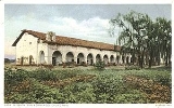
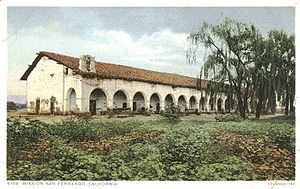
Mission San Fernando Rey de España
was founded at Reyes's original rancho site on September 8, 1797 by Father Fermín Lasuén
. The mission's grazing lands extended over the flatlands of the valley, and it also claimed jurisdiction over several smaller valleys to the north and west. From this time the valley began to be called after the mission.
The fathers were charged with "civilizing" the native peoples, which they named according to the mission which had jurisdiction over them. The native peoples associated with Mission San Fernando were called Fernandeños regardless of tribal affiliation or language, as those associated with Mission San Gabriel were called Gabrielinos. As the 19th century dawned, 541 Indians did the heavy work of the Mission San Fernando, tending the livestock and working the farmlands watered by irrigation from the mission's wells. The mission was famed for its red wine, and also grew pomegranate
s, figs and olives. By 1826, 56,000 longhorn cattle and 1,500 horses grazed on the mission lands of the valley floor.
In 1821, Mexico achieved its independence
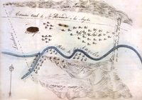
from Spain, and California came under control of the Mexican government. The 1824 Mexican Colony Law established rules for petitioning for land grants to individuals in California. Regulations enacted in 1828 attempted to break the monopoly of the missions and also made land grants easier to obtain. The procedure included a diseño - a hand drawn sketch map. The Mexican Governors of Alta California gained the power to grant state lands, and many of the earlier Spanish grazing concessions were subsequently patented under Mexican law.
Many Californio
s in the Los Angeles area wanted the mission's rich grazing lands to be made available to private citizens, while those in the north, including Mexican governor General Manuel Victoria
, preferred to keep the mission system intact. Late in 1831, the Californios rose in armed rebellion against the governor, who led a party of soldiers to the Valley to put down the rebellion. The southern ranchers rode into the Valley via the Cahuenga Pass
and the two armies faced off in a skirmish (Battle of Cahuenga Pass
) that left one man dead on either side. Although the rebels retreated to the pueblo, they were victorious in defeat; the wounded governor resigned and returned to Mexico. Popular pressure increased on the government to disestablish the missions, and laws were passed to secularize the missions on August 17, 1833.
In 1843, Don Vicente de la Osa (or del la Ossa) was granted one league of land along the Los Angeles River at the southeast corner of the Valley which he named Rancho Providencia
. The nearby Battle of Providencia
of February 20, 1845, was another face-off between Californios and an unpopular Mexican governor, Manuel Micheltorena
, who proposed to return the mission lands to the control of the church. The only reported fatalities in the day-long cannon battle along the river were two horses and a mule, but Governor Micheltorena was captured and summarily shipped back to Mexico. He was replaced by Pío Pico
, a native Californio, who would become the last Mexican governor of California.,
 California was "land rich but poor in every other way, lacking cash, gunpowder, and support from Mexico." Governor Pico prepared for the inevitable war with the United States, and in 1845 began dispersing the vast mission lands. A square of land at the west end of the Valley near the historic Chumash village Hu'wam was granted to three of the mission Indians under the name Rancho El Escorpión
. The majority of the mission's grazing lands and mission buildings were leased to the governor's brother Andrés Pico
. After the United States declared war on Mexico on May 13, 1846, Pico sold the mission property outright to Eulogio de Celis for much-needed cash; Celis graciously extended the terms of his friend Andrés Pico's lease. From this time the property was known as Rancho Ex-Mission San Fernando
.
On June 18, 1846 a small group of Yankee
s raised the California Bear Flag and declared independence from Mexico. United States
troops quickly took control of the presidio
s at Monterey
and San Francisco
and proclaimed the Conquest complete. In Southern California, the Mexicans, for a time, resisted American troops, but when defeat became inevitable, Pío Pico fled to Mexico. Don Andrés Pico arranged the peaceful surrender of Los Angeles to American forces under Lieutenant-Colonel John C. Frémont
. The Capitulation Agreement ending the hostilities in California was signed at an adobe owned by the Verdugo Family at Campo de Cahuenga
near the mouth of the Cahuenga Pass, at the southeast corner of the Valley, on January 13, 1847.
The Treaty of Guadalupe Hidalgo
, signed on February 2, 1848, ended the war and ceded California to the United States, paving the way for California statehood in 1850.
of 1849 created a near-insatiable demand for beef, which was raised on the ranchos of southern California, including those in the San Fernando Valley, and driven on the hoof to northern markets serving the gold fields. In the southern Valley, de la Osa sold Rancho La Providencia to David W. Alexander and acquired the Rancho Encino, successfully raising cattle on the property. De la Osa took formal title to the Rancho under California law in 1851.
Andrés Pico returned to his rancho in the Valley and made the former mission into "one of the most celebrated homes in the new California." After California became a state on September 9, 1850, Pico served as a state assemblyman and senator, and became a brigadier general in the state militia. In 1854, Andrés Pico's nine-year lease on the Rancho Ex-Mission San Fernando expired, and he purchased a half-interest in the property.
 In 1851 the Los Angeles Court of Sessions recognized two rights of way through the Cahuenga Pass that connected Los Angeles with the Valley. One followed the old El Camino Real
to Santa Barbara
via Rancho Encino. The other, Tulare Road, joined El Camino Viejo ("the old road") north via Mission San Fernando, over the San Fernando Pass (now the Newhall Pass) to the Santa Clarita Valley, and through the Tejon Pass
to the Central Valley and the gold fields beyond. In 1854, the Army established Fort Tejon
in the Grapevine Canyon
(La Cañada de las Uvas) near Tejon Pass. The Los Angeles County Board of Supervisors authorized funds to construct a 30 feet (9.1 m) deep cut to make the steep route north over the San Fernando Pass easier for stagecoach
traffic, and a group of businessmen raised funds by subscription to complete the work. Young entrepreneur Phineas Banning
's staging and shipping
partnership with County Supervisor David W. Alexander acquired the contract to supply Fort Tejon, and Banning drove the first stage run over the new cut in December 1854.
The Butterfield Overland Mail
stagecoach route between St. Louis, Missouri
and San Francisco, California
via Fort Yuma
and Los Angeles
made its first run in the fall of 1858. The original route entered the Valley through Cahuenga Pass
and traveled northwest to the San Fernando Pass with a stage stop at Lopez Station north of the mission.
In 1859, the California Legislature appropriated $15,000 (with additional funding provided by Los Angeles and Santa Barbara Counties) towards improving the old Santa Susana Pass
wagon road into a new stagecoach road, now known as the Old Santa Susana Stage Road. The road ran over the Simi Hills
between Santa Susana (now Chatsworth
) and the Simi Valley
. The precipitous portion of the route down from the summit on the San Fernando Valley side was called the Devil's Slide; horses were usually blindfolded and chains were used to augment brakes on the steep descent. Passengers debarked and walked.
Southern California's boom market in beef had begun to decline as early as 1855 as it became profitable to drive cattle and sheep to California from the Midwest and Texas
, and a drought
in 1856 increased the pressure on the ranchos. By 1859, with the cattle market in collapse and besieged by mounting debts, De la Osa converted his house at Rancho Encino into a roadside inn and began to charge patrons for his legendary Californio hospitality.
The outbreak of the Civil War
in 1861 disrupted mail service to California from the east via the old southerly "oxbow route". That year Butterfield obtained a new contract to deliver mail between Los Angeles and San Francisco via a route diverging from the old road at the southeast corner of the Valley and traveling via the former El Camino Real as far as Rancho Encino before striking northwest across the valley floor for Santa Barbara via the recently improved Santa Susana wagon road over the Santa Susana Pass
. This road became the main passenger route between Los Angeles and San Francisco, although traffic over the San Fernando Pass to the Central Valley continued.
 The devastation that ravaged the old rancho way of life between 1861 and 1865 had little to do with the Civil War raging to the east. The rains that started shortly before Christmas, 1861, continued for most of the following month. The flooding that followed drowned thousands of cattle and washed away fruit trees and vineyards. The Los Angeles Star reported that
No mail was received at Los Angeles for five weeks. After the floods abated, grazing lands were turned into lush meadows and cattle flourished on the abundant grass. Surveyor General Edward Fitzgerald Beale
had the damaged cut in the San Fernando Pass deepened to 90 feet (27.4 m) and named the slot-like roadway Beale's Cut. But the reprieve was only brief.
The flood of 1861–62 was followed by severe drought
s in 1863 and 1864. Cattle perished, or were slaughtered and sold for the salvage value of their hides and horn, and land values plummeted. Ravenous locusts and a major smallpox
epidemic
completed the devastation. The rancho economy of the Dons and the Californio way of life fell to a wave of overwhelming debt and unpaid taxes, never to rise again.
. Burbank combined his properties into a nearly 9000 acres (36.4 km²) cattle ranch.
That same year, De La Osa's widow sold Rancho Encino to James Thompson, who raised sheep on the rancho for two years. Thompson in turn sold the property to the Garnier brothers in 1869. The Garniers also raised sheep on the property, and were known for the fine quality of their fleece, but they in turn became overextended and lost the property to foreclosure in 1878.
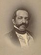
Eulogio de Celis had tried to sell his vast holdings in the Valley, but found no buyers. Squeezed by debt after the flood years, Andrés Pico had sold his half-interest in the Rancho ex-Mission San Fernando to his brother Pío Pico in 1862, retaining 2000 acres (8 km²) called the Pico Reserve around the old Mission. When De Celis died in 1869, Pío Pico, desperately in need of cash, sold his half-share to a group of investors assembled as the San Fernando Farm Homestead Association. The leading investor was Isaac Lankershim, a Northern California stockman and grain farmer, who was impressed by the Valley's wild oats and proposed to raise sheep on the property. Other investors included Levi Strauss
. To complete the sale, the Valley was split lengthwise, with the Association purchasing the southern half and the northern half devolving to De Celis's heirs. The line of demarcation was a ploughed furrow across the Valley floor near the route of today's Roscoe Boulevard. In 1873, Isaac Lankershim's son and future son-in-law, James Boon (J. B.) Lankershim and Isaac Newton Van Nuys
, moved to the Valley and took over management of the property. Van Nuys built the first wood-frame house in the Valley. Initially the two men raised sheep, changing the name of the company to the San Fernando Sheep Company. Van Nuys, however, thought the property could profitably grow wheat using the dryland farming
technique developed on the Great Plains
, and leased land from the Association to test his theories. After a drought destroyed the majority of the sheep in 1875, the remainder of the property was given over to raising wheat and barley. In time the Lankershim property, under its third name, the Los Angeles Farming and Milling Company, would become the world's largest wheat-growing empire.
 A 56000 acres (227 km²) parcel of De Celis's property north of the great furrow was purchased in 1874 by state senator Charles Maclay
of Santa Clara
and his partner, George K. Porter of San Francisco. Porter's cousin Benjamin F. Porter subsequently purchased portions of Porter and Maclay's interests. Most of the land except the parcel northeast of the mission was used for wheat farming. Ben Porter's portion to the west (now Porter Ranch
) remained one of the last parts of the Valley to be developed.
In the eastern section nearest the San Gabriel Mountains
, Maclay plat
ted the Valley's first town, San Fernando
, on September 15, 1874. The town plan included land for a station for Leland Stanford
's Southern Pacific Railroad from Los Angeles, which became the depot for the north Valley farmers to ship their wheat crops south to the port at Wilmington
. In 1876, Southern Pacific opened a tunnel through the pass at San Fernando and ran the first through train from the transcontinental railroad's western terminus in San Francisco to Los Angeles. From this time, rail travel superseded long distance travel by stagecoach in California.
 The world wheat market remained strong through the 1870s and early 1880s, but then supply began to exceed demand, and prices began to fall. When the rival Santa Fe Railroad reached Los Angeles in 1885, fare wars between the two transportation giants brought ever more settlers to Southern California, and pressure rose to subdivide the great ranches of the Valley. In 1886, David Burbank sold his ranch to Los Angeles land speculators who formed the Providencia Land, Water and Development Company, with Burbank as one of the directors. The land was surveyed and a business district was laid out, surrounded by residential lots. The outlying area was divided into small farms. They named the town Burbank
and opened the tract for sale on May 1, 1887.
In October 1887, J. B. Lankershim and eight other developers organized the Lankershim Ranch Land and Water Company, purchasing 12000 acres (49 km²) north of the Caheunga Pass from the Lankershim Farming and Milling Company. Lankershim established a townsite which the residents named Toluca
(later Lankershim, and now North Hollywood) along the old Tulare Road from Cahuenga Pass to San Fernando. On April 1, 1888, they offered ready-made small farms for sale, already planted with deep-rooted deciduous fruit and nut trees—mostly peaches, pears, and walnuts—that could survive the rainless summers of the Valley by relying on the high water table
along the Pacoima River (now the central or main branch of the Tujunga Wash
) rather than surface irrigation.
In 1888, Ben Porter sold a portion of his property near the base of Santa Susana Pass to the Porter Land and Water Company, which platted it as the community of Chatsworth Park
.
The land boom of the 1880s went bust by the 1890s, but despite another brutal drought cycle in the late 1890s, the fruit and nut farmers remained solvent for a time. The Toluca Fruit Growers Association was formed in 1894. The next year the Southern Pacific opened a branch line slanting northwest across the Valley to Chatsworth Park, which made one freight stop a day at Toluca, though the depot bore the new name of Lankershim. In 1896, under pressure from J. B. Lankershim, the post office at Toluca was renamed "Lankershim" after his father, although the new name of the town would not be officially recognized until 1905.
A new Santa Susana Pass wagon route bypassing the deteriorating Devil's Slide was opened in 1895 to the north. Initially called El Camino Nuevo (the New Road), it was later named the Chatsworth Grade Road, which continued in use until Santa Susana Pass Road (now Old Santa Susana Pass Road) was built in 1917. This was the first automobile route between the San Fernando and Simi Valleys. It also was the main northbound 'coast road' to Santa Barbara
and San Francisco, until the Conejo Grade in Ventura County between Conejo Valley
and the Oxnard Plain
on "Camino Real Viejo"
(the Old Royal Road, now U.S. Route 101
), was improved. Rail traffic through Toluca and Chatsworth Park to Ventura County and points north was made possible by the opening of the Santa Susana Tunnels in 1904, and the new route soon superseded the old rail route to San Francisco via the San Fernando Pass for passenger travel, as that route had superseded the stagecoach route via Santa Susana Pass in the 1870s.
Late in the decade the City of Los Angeles sued all the ranchers of the Valley, claiming the rights not only to the surface water of the Los Angeles River and its tributaries, but to the groundwater as well. In 1899, the California Supreme Court sided with the city. Without a reliable water supply, it became impossible to sell farm sites in the Valley.
. In 1904, Brand's syndicate incorporated as the San Fernando Mission Land Company, whose major shareholders included Los Angeles businessmen Harrison Gray Otis and Moses Sherman
. One day after the city water commission, on which Moses Sherman sat, approved a proposal to build an aqueduct
from the Owens Valley
, the Company quietly exercised its option to purchase Porter's land.
On July 29, 1905, the City announced its plans to bring water south from the Owens Valley—water that would only be made available to city residents. Construction began in 1908 and water from the Los Angeles Aqueduct
reached the San Fernando Valley in November, 1913.
 Real estate development once again boomed. In the "biggest land transaction ever recorded in Los Angeles County", a syndicate led by Harry Chandler
, business manager of the Los Angeles Times
, with Hobart Johnstone Whitley
, Isaac Van Nuys
, and James Boon Lankershim acquired "Tract 1000", the remaining 47500 acres (192 km²) of the southern half of the former Mission lands—everything west of the Lankershim town limits and south of the old furrow excepting the Rancho Encino. As the Los Angeles Suburban Homes company, they laid out plans for the towns of Van Nuys
, Marion
(now Reseda) and Owensmouth
(now Canoga Park
, West Hills
, and Winnetka
), a system of highways, and eventual incorporation into the city of Los Angeles. In the "Sale of the Century" in November 1910 they sold the remaining livestock and non-land assets of the Lankershim Farming and Milling Company at auction. The Los Angeles Times called the auction "the beginning of a new empire and a new era in the Southland".
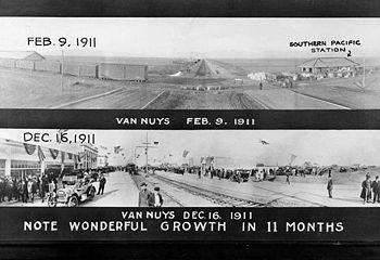
Times were indeed changing quickly. The City of Burbank was incorporated in 1911., and the Pacific Electric Railway
reached Van Nuys on December 16, 1911, Owensmouth on December 7, 1912, and San Fernando on March 22, 1913. In 1914, Carl Laemmle
broke ground on a permanent movie-making facility on the Oak Ridge Ranch in the hills east of the mouth of the Cahuenga Pass that would become Universal City
.
Portola expedition
250px|right|Point of San Francisco Bay DiscoveryThe Portolá Expedition was led by Gaspar de Portolá from July 14, 1769 to January 24, 1770. It was the first recorded Spanish land entry and exploration of present day California, United States...
to the annexation of much of it by the City of Los Angeles in 1915 is a story of booms and busts, as cattle ranching, sheep ranching, large-scale wheat farming, and fruit orchards flourished and faded. Throughout its history, settlement in the San Fernando Valley
San Fernando Valley
The San Fernando Valley is an urbanized valley located in the Los Angeles metropolitan area of southern California, United States, defined by the dramatic mountains of the Transverse Ranges circling it...
(usually called simply "The Valley") was shaped by availability of reliable water supplies and by proximity to the major transportation routes through the surrounding mountains.
Topography and early settlement
Before the flood controlFlood control
In communications, flood control is a feature of many communication protocols designed to prevent overwhelming of a destination receiver. Such controls can be implemented either in software or in hardware, and will often request that the message be resent after the receiver has finished...
measures of the 20th century, the location of human settlements in the San Fernando Valley was constrained by two forces: the necessity of avoiding winter flood
Flood
A flood is an overflow of an expanse of water that submerges land. The EU Floods directive defines a flood as a temporary covering by water of land not normally covered by water...
s and need for year-round water sources to sustain communities through the dry summer and fall months. In winter, torrential downpours over the western-draining watershed of the San Gabriel Mountains
San Gabriel Mountains
The San Gabriel Mountains Range is located in northern Los Angeles County and western San Bernardino County, California, United States. The mountain range lies between the Los Angeles Basin and the Mojave Desert, with Interstate 5 to the west and Interstate 15 to the east...
entered the northeast Valley through Big Tujunga Canyon, Little Tujunga Canyon, and Pacoima Canyon. These waters spread over the Valley floor in a series of braided washes
Tujunga Wash
Tujunga Wash is a stream in Los Angeles County, California. It is a tributary of the Los Angeles River, providing about a fifth of its flow, and drains about...
that was seven miles wide as late as the 1890s, periodically cutting new channels and reusing old ones, before sinking into the gravelly subterranean reservoir
Reservoir
A reservoir , artificial lake or dam is used to store water.Reservoirs may be created in river valleys by the construction of a dam or may be built by excavation in the ground or by conventional construction techniques such as brickwork or cast concrete.The term reservoir may also be used to...
below the eastern Valley and continuing their southward journey underground. Only when the waters encountered the rocky roots of the Santa Monica Mountains
Santa Monica Mountains
The Santa Monica Mountains are a Transverse Range in Southern California, along the coast of the Pacific Ocean in the United States.-Geography:...
were they pushed to the surface where they fed a series of tule
Tule
Schoenoplectus acutus , called tule , common tule, hardstem tule, tule rush, hardstem bulrush, or viscid bulrush, is a giant species of sedge in the plant family Cyperaceae, native to freshwater marshes all over North America...
marsh
Marsh
In geography, a marsh, or morass, is a type of wetland that is subject to frequent or continuous flood. Typically the water is shallow and features grasses, rushes, reeds, typhas, sedges, other herbaceous plants, and moss....
es, slough
Slough
Slough is a borough and unitary authority within the ceremonial county of Royal Berkshire, England. The town straddles the A4 Bath Road and the Great Western Main Line, west of central London...
s, and the sluggish stream that is now the Los Angeles River
Los Angeles River
The Los Angeles River is a river that starts in the San Fernando Valley, in the Simi Hills and Santa Susana Mountains, and flows through Los Angeles County, California, from Canoga Park in the western end of the San Fernando Valley, nearly southeast to its mouth in Long Beach...
.
By the time the Spanish conquest of Mexico
Mexico
The United Mexican States , commonly known as Mexico , is a federal constitutional republic in North America. It is bordered on the north by the United States; on the south and west by the Pacific Ocean; on the southeast by Guatemala, Belize, and the Caribbean Sea; and on the east by the Gulf of...
reached Alta California
Alta California
Alta California was a province and territory in the Viceroyalty of New Spain and later a territory and department in independent Mexico. The territory was created in 1769 out of the northern part of the former province of Las Californias, and consisted of the modern American states of California,...
in 1769, successive groups of indigenous peoples, or Native Americans
Native Americans in the United States
Native Americans in the United States are the indigenous peoples in North America within the boundaries of the present-day continental United States, parts of Alaska, and the island state of Hawaii. They are composed of numerous, distinct tribes, states, and ethnic groups, many of which survive as...
, had inhabited the area for at least 7,000 years. These peoples tended to settle on well-watered and wooded areas at the Valley's margins. The Tongva, who spoke the Tongva language
Tongva language
-Collected by C. Hart Merriam :Numbers# Po-koo /bo'kʰøː/# Wěh-hā /ʋɛj'χɒː/# Pah-hā /pa'χɒː/# Wah-chah /ʋa'ʃɒχ/# Mah-har /ma'χɒʁ/# Pah-vah-hā /pa'va'χɒː/# Wah-chah-kav-e-ah /ʋa'ʃa'kʰav̥eʲa/...
, a Uto-Aztecan or Shoshonean language
Uto-Aztecan languages
Uto-Aztecan or Uto-Aztekan is a Native American language family consisting of over 30 languages. Uto-Aztecan languages are found from the Great Basin of the Western United States , through western, central and southern Mexico Uto-Aztecan or Uto-Aztekan is a Native American language family...
, had a series of villages in the southern Valley along or near the river, including Totongna (near modern-day Calabasas
Calabasas, California
Calabasas is an affluent city in Los Angeles County, California in the western United States. It is located in the hills in the southwestern San Fernando Valley and the Santa Monica Mountains between Woodland Hills, Agoura Hills, West Hills, and Malibu, California. As of the 2010 census, the city...
), Siutcanga (near Encino
Encino, Los Angeles, California
Encino is a hilly district of the city of Los Angeles, California, United States. Specifically, it is located in the central portion of the southern San Fernando Valley and on the north slope of the Santa Monica Mountains...
) and Kawengna (which the Spanish would write as Cahuenga). In the north-central Valley was an apparently permanent village called Pasakngna, in the lower foothills of the mountains near natural springs and a tule marsh. Other characteristic place-names of Tongva origin in the Valley include Tujunga and Topanga
Topanga, California
Topanga is a census-designated place in western Los Angeles County, California, USA. It is located in the Santa Monica Mountains. Occupying Topanga Canyon, it is often referred to by that name. Topanga is bounded on three sides by State Park or conservancy lands, and on the south by the Pacific...
. The Tataviam
Tataviam
The Tataviam , were called the Alliklik by their neighbors the Chumash , are a Native American group in southern California...
were established in the valleys to the north; Pacoima
Pacoima, Los Angeles, California
Pacoima is a district in the San Fernando Valley region of the city of Los Angeles, California.It is bordered by the Los Angeles districts of Mission Hills on the west, Arleta on the south, Sun Valley on the southeast, Lake View Terrace on the northeast, and by the city of San Fernando on the north...
is believed to be of Tataviam-Fernandeño
Tataviam
The Tataviam , were called the Alliklik by their neighbors the Chumash , are a Native American group in southern California...
people's Tataviam language
Tataviam language
The Tataviam language was spoken by the Tataviam people of the upper Santa Clara River basin, Santa Susana Mountains, and Sierra Pelona Mountains in southern California. It had become extinct by 1916 and is known only from a few early records, notably a word list collected by the linguist John P...
origin.
The Hokan
Hokan languages
The Hokan language family is a hypothetical grouping of a dozen small language families spoken in California, Arizona and Mexico. In nearly a century since Edward Sapir first proposed the "Hokan" hypothesis, little additional evidence has been found that these families were related to each other...
-speaking Chumash people inhabited Malibu, the Santa Monica Mountains
Santa Monica Mountains
The Santa Monica Mountains are a Transverse Range in Southern California, along the coast of the Pacific Ocean in the United States.-Geography:...
, and the Simi Hills
Simi Hills
The Simi Hills are a low rocky mountain range of the Transverse Ranges, located in eastern Ventura County and western Los Angeles County, of southern California, United States.-Geography:...
in the western area of the Valley, and much of the coastal areas to the northwest. At Bell Creek
Bell Creek (Southern California)
Bell Creek is a tributary of the Los Angeles River, in the Simi Hills of Ventura County and the San Fernando Valley of Los Angeles County and City, in Southern California.-Route:...
below the rocky outcropping called Escorpión Peak (Castle Peak), Chumash pictographs
Pictogram
A pictograph, also called pictogram or pictogramme is an ideogram that conveys its meaning through its pictorial resemblance to a physical object. Pictographs are often used in writing and graphic systems in which the characters are to considerable extent pictorial in appearance.Pictography is a...
and other artifacts have been identified by archeologists at a site, Hu'wam, which is thought to have been a meeting place and trading center for the Tongva-Fernandeño and Chumash-Venturaño. In the Simi Hills
Simi Hills
The Simi Hills are a low rocky mountain range of the Transverse Ranges, located in eastern Ventura County and western Los Angeles County, of southern California, United States.-Geography:...
the Burro Flats Painted Cave
Burro Flats Painted Cave
Burro Flats Painted Cave is in the Burro Flats area of the Simi Hills, located between the Simi Valley, and West Hills and Bell Canyon, in Ventura County of Southern California, United States. It is a Cave containing Chumash Native American pictographs...
pictographs are located on Rocketdyne's Santa Susana Field Laboratory
Santa Susana Field Laboratory
The Santa Susana Field Laboratory is a complex of industrial research and development facilities located on a 2,668 acre portion of the Southern California Simi Hills in Simi Valley, California, used mainly for the testing and development of Liquid-propellant rocket engines for the United States...
property, inaccessible but well protected. The Tataviam-Fernandeño
Tataviam
The Tataviam , were called the Alliklik by their neighbors the Chumash , are a Native American group in southern California...
people inhabited the foothills of the Santa Susana Mountains
Santa Susana Mountains
The Santa Susana Mountains are a transverse range of mountains in southern California, north of the city of Los Angeles, in the United States. The range runs east-west separating the San Fernando Valley and Simi Valley on its south, from Santa Clara River Valley to the north, and Santa Clarita...
in the Valley (and north in the Santa Clara River
Santa Clara River (California)
The Santa Clara River is approximately long, located in southern California in the United States. It drains an area of the coastal mountains north of Los Angeles. The Santa Clara is one of the largest river systems along the coast of Southern California and one of only a few remaining river...
area). The Tongva-Fernandeño inhabited the Valley, along the tributaries to the Los Angeles River
Los Angeles River
The Los Angeles River is a river that starts in the San Fernando Valley, in the Simi Hills and Santa Susana Mountains, and flows through Los Angeles County, California, from Canoga Park in the western end of the San Fernando Valley, nearly southeast to its mouth in Long Beach...
.
Exploration
In 1769 the expeditionPortola expedition
250px|right|Point of San Francisco Bay DiscoveryThe Portolá Expedition was led by Gaspar de Portolá from July 14, 1769 to January 24, 1770. It was the first recorded Spanish land entry and exploration of present day California, United States...
led by explorer Gaspar de Portolà
Gaspar de Portolà
Gaspar de Portolà i Rovira was a soldier, governor of Baja and Alta California , explorer and founder of San Diego and Monterey. He was born in Os de Balaguer, province of Lleida, in Catalonia, Spain, of Catalan nobility. Don Gaspar served as a soldier in the Spanish army in Italy and Portugal...
reached the Los Angeles area of California overland from Baja California
Baja California
Baja California officially Estado Libre y Soberano de Baja California is one of the 31 states which, with the Federal District, comprise the 32 Federal Entities of Mexico. It is both the northernmost and westernmost state of Mexico. Before becoming a state in 1953, the area was known as the North...
. Accompanying him were two Franciscan Padres, Junípero Serra
Junípero Serra
Blessed Junípero Serra, O.F.M., , known as Fra Juníper Serra in Catalan, his mother tongue was a Majorcan Franciscan friar who founded the mission chain in Alta California of the Las Californias Province in New Spain—present day California, United States. Fr...
and Juan Crespí
Juan Crespi
Father Juan Crespí was a Majorcan missionary and explorer of Las Californias. He entered the Franciscan order at the age of seventeen. He came to America in 1749, and accompanied explorers Francisco Palóu and Junípero Serra. In 1767 he went to the Baja Peninsula and was placed in charge of the...
, who recorded the expedition and identified locations for a proposed network of missions, along which the royal highway (El Camino Real)
El Camino Real (California)
El Camino Real and sometimes associated with Calle Real usually refers to the 600-mile California Mission Trail, connecting the former Alta California's 21 missions , 4 presidios, and several pueblos, stretching from Mission San Diego de Alcalá in San Diego...
was eventually built.
After camping at and naming the location that would become the Pueblo de Los Angeles
Pueblo de Los Angeles
El Pueblo de Nuestra Señora la Reina de los Ángeles was the Spanish civilian pueblo founded in 1781, which by the 20th century became the American metropolis of Los Angeles....
, the expedition proceeded westward before turning north through the Sepulveda Pass
Sepulveda Pass
Sepulveda Pass is a mountain pass through the Santa Monica Mountains in Los Angeles.It connects the Los Angeles Basin to the San Fernando Valley via the San Diego Freeway and Sepulveda Boulevard and experiences heavy traffic on a regular basis, commonly experiencing major traffic slowdowns and...
over the Santa Monica Mountains
Santa Monica Mountains
The Santa Monica Mountains are a Transverse Range in Southern California, along the coast of the Pacific Ocean in the United States.-Geography:...
on the feast day of Saint Catherine of Bologna.
The watering place was a pool fed by a perennial spring at what is now Encino, near the village of Siutangna. The name El Valle de Santa Catalina de Bononia de los Encinos refers to the encinos or evergreen Coast Live Oak
Coast Live Oak
Quercus agrifolia, the Coast Live Oak, is an evergreen oak , native to the California Floristic Province. It grows west of the Sierra Nevada from Mendocino County, California, south to northern Baja California in Mexico. It is classified in the red oak section Quercus agrifolia, the Coast Live Oak,...
s that studded the area. The expedition proceeded northward, camping at a site in the northern Valley before crossing over the mountains into the Santa Clarita Valley
Santa Clarita Valley
The Santa Clarita Valley is the valley of the Santa Clara River in Southern California. It stretches through Los Angeles County and Ventura County. Its main population center is the city of Santa Clarita. The valley was part of the Rancho San Francisco Mexican land grant...
.
Father Crespí had identified a location along the Los Angeles River
Los Angeles River
The Los Angeles River is a river that starts in the San Fernando Valley, in the Simi Hills and Santa Susana Mountains, and flows through Los Angeles County, California, from Canoga Park in the western end of the San Fernando Valley, nearly southeast to its mouth in Long Beach...
that would be perfect for a settlement, possibly a mission, but in 1781, King Charles III of Spain
Charles III of Spain
Charles III was the King of Spain and the Spanish Indies from 1759 to 1788. He was the eldest son of Philip V of Spain and his second wife, the Princess Elisabeth Farnese...
ordered that a pueblo
Pueblo
Pueblo is a term used to describe modern communities of Native Americans in the Southwestern United States of America. The first Spanish explorers of the Southwest used this term to describe the communities housed in apartment-like structures built of stone, adobe mud, and other local material...
be built on the site, which would be the second town in Alta California after San José de Guadalupe
History of San Jose, California
-Site chosen by De Anza:For thousands of years before the arrival of European settlers, the area now known as San Jose was inhabited by several groups of Ohlone Native Americans...
, founded in 1777. By royal edict, all of the waters of the river and its tributaries were reserved for the Pueblo de Los Angeles, a condition which would have a profound impact on development of the Valley.
Mission San Fernando
Ranchos of California
The Spanish, and later the Méxican government encouraged settlement of territory now known as California by the establishment of large land grants called ranchos, from which the English ranch is derived. Devoted to raising cattle and sheep, the owners of the ranchos attempted to pattern themselves...
north of the pueblo that included the southeastern corner of the Valley, Rancho San Rafael
Rancho San Rafael
Rancho San Rafael was a Spanish land grant bordering the Los Angeles River and the Arroyo Seco in present day Los Angeles County, California, given in 1784 to Jose Maria Verdugo. The rancho includes the present day cities of Glendale, Eagle Rock, La Cañada, Montrose, and Verdugo City...
and Rancho Portesuelo. Francisco Reyes
Juan Francisco Reyes (soldier)
Juan Francisco Reyes , soldado de cuero on the 1769 Portola expedition, alcalde of the Pueblo de Los Angeles for three terms, and recipient of the Spanish land grant for Los Encino and later Lompoc.-Juan Francisco Reyes:In 1769 Francisco Reyes, left his home in Mexico to join the Spanish army...
, alcalde
Alcalde
Alcalde , or Alcalde ordinario, is the traditional Spanish municipal magistrate, who had both judicial and administrative functions. An alcalde was, in the absence of a corregidor, the presiding officer of the Castilian cabildo and judge of first instance of a town...
or mayor of Los Angeles from 1793–1795, had set up a grazing operation which he called Rancho Encino located in what is now Mission Hills
Mission Hills, Los Angeles, California
Mission Hills is a suburban community in the San Fernando Valley region of the city of Los Angeles, California.It is located near the northern junction of the Golden State Freeway and the San Diego Freeway . The Ronald Reagan Freeway bisects the neighborhood. Mission Hills is the northern...
near the village of Pasakngna. Reyes's property had a substantial water supply from artesian wells and limestone for building, and was situated a day's walk from the existing missions San Gabriel and San Buenaventura
Mission San Buenaventura
Mission San Buenaventura was founded on Easter Sunday, March 31, 1782 in Las Californias, part of the Spanish Viceroyalty of New Spain. Named for a Franciscan theologian, Saint Bonaventure, it was the last of the missions founded by Father Serra...
. In or shortly before 1797 he was persuaded to cede this land to the Franciscans to be the site of a new mission, receiving in exchange a square league (4460 acres (18 km²)) of land in the southern valley by the perennial spring where the Portola Expedition had first entered the Valley. This property he also called Rancho Encino
Rancho Los Encinos
Rancho Los Encinos was a Spanish grazing concession, and later Mexican land granted cattle and sheep rancho and travelers way-station on the El Camino Real in the San Fernando Valley, in present day Encino, Los Angeles County, California...
(also recorded as El Encino and Los Encinos).
Mission San Fernando Rey de España
Mission San Fernando Rey de España
Mission San Fernando Rey de España was founded on "The Feast of the Birth of Mary" , 1797. The settlement is located on the former Encino Rancho in the Mission Hills community of northern Los Angeles, near the site of the first gold discovery in Alta California.-History:Mission San Fernando Rey de...
was founded at Reyes's original rancho site on September 8, 1797 by Father Fermín Lasuén
Fermín Lasuén
Father Padre Fermín de Francisco Lasuén de Arasqueta was a Spanish missionary to Alta California, the second presidente and founder of the California Franciscan Mission Chain....
. The mission's grazing lands extended over the flatlands of the valley, and it also claimed jurisdiction over several smaller valleys to the north and west. From this time the valley began to be called after the mission.
The fathers were charged with "civilizing" the native peoples, which they named according to the mission which had jurisdiction over them. The native peoples associated with Mission San Fernando were called Fernandeños regardless of tribal affiliation or language, as those associated with Mission San Gabriel were called Gabrielinos. As the 19th century dawned, 541 Indians did the heavy work of the Mission San Fernando, tending the livestock and working the farmlands watered by irrigation from the mission's wells. The mission was famed for its red wine, and also grew pomegranate
Pomegranate
The pomegranate , Punica granatum, is a fruit-bearing deciduous shrub or small tree growing between five and eight meters tall.Native to the area of modern day Iran, the pomegranate has been cultivated in the Caucasus since ancient times. From there it spread to Asian areas such as the Caucasus as...
s, figs and olives. By 1826, 56,000 longhorn cattle and 1,500 horses grazed on the mission lands of the valley floor.
Ranchos
In 1821, Mexico achieved its independence
Mexican War of Independence
The Mexican War of Independence was an armed conflict between the people of Mexico and the Spanish colonial authorities which started on 16 September 1810. The movement, which became known as the Mexican War of Independence, was led by Mexican-born Spaniards, Mestizos and Amerindians who sought...
from Spain, and California came under control of the Mexican government. The 1824 Mexican Colony Law established rules for petitioning for land grants to individuals in California. Regulations enacted in 1828 attempted to break the monopoly of the missions and also made land grants easier to obtain. The procedure included a diseño - a hand drawn sketch map. The Mexican Governors of Alta California gained the power to grant state lands, and many of the earlier Spanish grazing concessions were subsequently patented under Mexican law.
Many Californio
Californio
Californio is a term used to identify a Spanish-speaking Catholic people, regardless of race, born in California before 1848...
s in the Los Angeles area wanted the mission's rich grazing lands to be made available to private citizens, while those in the north, including Mexican governor General Manuel Victoria
Manuel Victoria
Manuel Victoria was Governor of the Mexican territory of Alta California from January 1831 to 6 December 1831.The revolt leading to his twelve month abbreviated tenure and subsequent exile were due to his nullifying the order of his predecessor, José María de Echeandía, to secularize the missions...
, preferred to keep the mission system intact. Late in 1831, the Californios rose in armed rebellion against the governor, who led a party of soldiers to the Valley to put down the rebellion. The southern ranchers rode into the Valley via the Cahuenga Pass
Cahuenga Pass
The Cahuenga Pass is a mountain pass through the eastern end of the Santa Monica Mountains in the Hollywood district of the City of Los Angeles, California....
and the two armies faced off in a skirmish (Battle of Cahuenga Pass
Battle of Cahuenga Pass
The Battle of Cahuenga Pass of 1831 was fought near Los Angeles between the unpopular Mexican Governor of California , and local settlers. Two men, Pacheco on the one side and Avila on the other, were killed...
) that left one man dead on either side. Although the rebels retreated to the pueblo, they were victorious in defeat; the wounded governor resigned and returned to Mexico. Popular pressure increased on the government to disestablish the missions, and laws were passed to secularize the missions on August 17, 1833.
In 1843, Don Vicente de la Osa (or del la Ossa) was granted one league of land along the Los Angeles River at the southeast corner of the Valley which he named Rancho Providencia
Rancho Providencia
Rancho La Providencia was a Mexican land grant in present day Los Angeles County, California given by governor Juan B. Alvarado in 1843 to Vincente de la Osa. The majority of Rancho Providencia land north of the modern channel of the Los Angeles River is now part of Burbank. The street grid...
. The nearby Battle of Providencia
Battle of Providencia
Battle of Providencia took place in 1845 on Rancho Providencia in the San Fernando Valley of southern California....
of February 20, 1845, was another face-off between Californios and an unpopular Mexican governor, Manuel Micheltorena
Manuel Micheltorena
Manuel Micheltorena was a Brigadier General of the Mexican Army, Adjutant-General of the same, Governor, Commandant-General and Inspector of the Department of the California...
, who proposed to return the mission lands to the control of the church. The only reported fatalities in the day-long cannon battle along the river were two horses and a mule, but Governor Micheltorena was captured and summarily shipped back to Mexico. He was replaced by Pío Pico
Pío Pico
Pío de Jesús Pico was the last Governor of Alta California under Mexican rule.-Origins:...
, a native Californio, who would become the last Mexican governor of California.,
Mexican-American War
Rancho El Escorpión
Rancho El Escorpión was a Mexican land grant in present day Los Angeles County, California given in 1845 by Governor Pío Pico to three Chumash Native Americans - Odón Eusebia, Urbano, and Mañuel....
. The majority of the mission's grazing lands and mission buildings were leased to the governor's brother Andrés Pico
Andrés Pico
Andrés Pico was a Californio who became a successful rancher, served as a military commander during the Mexican-American War; and was elected to the state assembly and senate after California became a state, when he was also commissioned as a brigadier general in the state militia.-Early...
. After the United States declared war on Mexico on May 13, 1846, Pico sold the mission property outright to Eulogio de Celis for much-needed cash; Celis graciously extended the terms of his friend Andrés Pico's lease. From this time the property was known as Rancho Ex-Mission San Fernando
Rancho Ex-Mission San Fernando
Rancho Ex-Mission San Fernando was a Mexican land grant in present day Los Angeles County, California granted in 1846 by Governor Pío Pico to Eulogio de Celis...
.
On June 18, 1846 a small group of Yankee
Yankee
The term Yankee has several interrelated and often pejorative meanings, usually referring to people originating in the northeastern United States, or still more narrowly New England, where application of the term is largely restricted to descendants of the English settlers of the region.The...
s raised the California Bear Flag and declared independence from Mexico. United States
United States
The United States of America is a federal constitutional republic comprising fifty states and a federal district...
troops quickly took control of the presidio
Presidio
A presidio is a fortified base established by the Spanish in North America between the sixteenth and nineteenth centuries. The fortresses were built to protect against pirates, hostile native Americans and enemy colonists. Other presidios were held by Spain in the sixteenth and seventeenth...
s at Monterey
Monterey, California
The City of Monterey in Monterey County is located on Monterey Bay along the Pacific coast in Central California. Monterey lies at an elevation of 26 feet above sea level. As of the 2010 census, the city population was 27,810. Monterey is of historical importance because it was the capital of...
and San Francisco
San Francisco, California
San Francisco , officially the City and County of San Francisco, is the financial, cultural, and transportation center of the San Francisco Bay Area, a region of 7.15 million people which includes San Jose and Oakland...
and proclaimed the Conquest complete. In Southern California, the Mexicans, for a time, resisted American troops, but when defeat became inevitable, Pío Pico fled to Mexico. Don Andrés Pico arranged the peaceful surrender of Los Angeles to American forces under Lieutenant-Colonel John C. Frémont
John C. Frémont
John Charles Frémont , was an American military officer, explorer, and the first candidate of the anti-slavery Republican Party for the office of President of the United States. During the 1840s, that era's penny press accorded Frémont the sobriquet The Pathfinder...
. The Capitulation Agreement ending the hostilities in California was signed at an adobe owned by the Verdugo Family at Campo de Cahuenga
Campo de Cahuenga
The Campo de Cahuenga, near the historic Cahuenga Pass in present day Studio City, Los Angeles, California, was an adobe ranch-house on the Rancho Cahuenga where the Treaty of Cahuenga was signed between Lieutenant Colonel John C. Frémont and General Andrés Pico in 1847, ending hostilities in...
near the mouth of the Cahuenga Pass, at the southeast corner of the Valley, on January 13, 1847.
The Treaty of Guadalupe Hidalgo
Treaty of Guadalupe Hidalgo
The Treaty of Guadalupe Hidalgo is the peace treaty, largely dictated by the United States to the interim government of a militarily occupied Mexico City, that ended the Mexican-American War on February 2, 1848...
, signed on February 2, 1848, ended the war and ceded California to the United States, paving the way for California statehood in 1850.
Cattle boom
The California Gold RushCalifornia Gold Rush
The California Gold Rush began on January 24, 1848, when gold was found by James W. Marshall at Sutter's Mill in Coloma, California. The first to hear confirmed information of the gold rush were the people in Oregon, the Sandwich Islands , and Latin America, who were the first to start flocking to...
of 1849 created a near-insatiable demand for beef, which was raised on the ranchos of southern California, including those in the San Fernando Valley, and driven on the hoof to northern markets serving the gold fields. In the southern Valley, de la Osa sold Rancho La Providencia to David W. Alexander and acquired the Rancho Encino, successfully raising cattle on the property. De la Osa took formal title to the Rancho under California law in 1851.
Andrés Pico returned to his rancho in the Valley and made the former mission into "one of the most celebrated homes in the new California." After California became a state on September 9, 1850, Pico served as a state assemblyman and senator, and became a brigadier general in the state militia. In 1854, Andrés Pico's nine-year lease on the Rancho Ex-Mission San Fernando expired, and he purchased a half-interest in the property.
Stage stops and the overland mail
El Camino Real (California)
El Camino Real and sometimes associated with Calle Real usually refers to the 600-mile California Mission Trail, connecting the former Alta California's 21 missions , 4 presidios, and several pueblos, stretching from Mission San Diego de Alcalá in San Diego...
to Santa Barbara
Santa Barbara, California
Santa Barbara is the county seat of Santa Barbara County, California, United States. Situated on an east-west trending section of coastline, the longest such section on the West Coast of the United States, the city lies between the steeply-rising Santa Ynez Mountains and the Pacific Ocean...
via Rancho Encino. The other, Tulare Road, joined El Camino Viejo ("the old road") north via Mission San Fernando, over the San Fernando Pass (now the Newhall Pass) to the Santa Clarita Valley, and through the Tejon Pass
Tejon Pass
The Tejon Pass is a mountain pass at the southwest end of the Tehachapi Mountains linking Southern to Central California.-Geography:The apex of the pass is near the northwesternmost corner of Los Angeles County, north of Gorman...
to the Central Valley and the gold fields beyond. In 1854, the Army established Fort Tejon
Fort Tejon
Fort Tejon in California is a former United States Army outpost which was intermittently active from June 24, 1854, until September 11, 1864. It is located in the Grapevine Canyon area of Tejon Pass along Interstate 5, the main route through the mountains separating the Central Valley from Los...
in the Grapevine Canyon
Grapevine, California
Grapevine is an unincorporated community in Kern County, California. At an elevation of 1499 feet , the community is located at the foot of a road grade known as The Grapevine through the Grapevine Canyon to Tejon Pass in the Tehachapi Mountains at the southern end of the San Joaquin Valley along...
(La Cañada de las Uvas) near Tejon Pass. The Los Angeles County Board of Supervisors authorized funds to construct a 30 feet (9.1 m) deep cut to make the steep route north over the San Fernando Pass easier for stagecoach
Stagecoach
A stagecoach is a type of covered wagon for passengers and goods, strongly sprung and drawn by four horses, usually four-in-hand. Widely used before the introduction of railway transport, it made regular trips between stages or stations, which were places of rest provided for stagecoach travelers...
traffic, and a group of businessmen raised funds by subscription to complete the work. Young entrepreneur Phineas Banning
Phineas Banning
Phineas Banning was an American businessman, financier, and entrepreneur.Known as "The Father of the Port of Los Angeles," he was one of the founders of the town of Wilmington, which was named for his birthplace...
's staging and shipping
Shipping
Shipping has multiple meanings. It can be a physical process of transporting commodities and merchandise goods and cargo, by land, air, and sea. It also can describe the movement of objects by ship.Land or "ground" shipping can be by train or by truck...
partnership with County Supervisor David W. Alexander acquired the contract to supply Fort Tejon, and Banning drove the first stage run over the new cut in December 1854.
The Butterfield Overland Mail
Butterfield Overland Mail
The Butterfield Overland Mail Trail was a stagecoach route in the United States, operating from 1857 to 1861. It was a conduit for the U.S. mail from two eastern termini, Memphis, Tennessee and St. Louis, Missouri, meeting Fort Smith, Arkansas, and continuing through Indian Territory, New Mexico,...
stagecoach route between St. Louis, Missouri
St. Louis, Missouri
St. Louis is an independent city on the eastern border of Missouri, United States. With a population of 319,294, it was the 58th-largest U.S. city at the 2010 U.S. Census. The Greater St...
and San Francisco, California
San Francisco, California
San Francisco , officially the City and County of San Francisco, is the financial, cultural, and transportation center of the San Francisco Bay Area, a region of 7.15 million people which includes San Jose and Oakland...
via Fort Yuma
Fort Yuma
Fort Yuma is a fort in California that is located in Imperial County, across the Colorado River from Yuma, Arizona. It was on the Butterfield Overland Mail route from 1858 until 1861 and was abandoned May 16, 1883, and transferred to the Department of the Interior. The Fort Yuma Indian School and a...
and Los Angeles
Los Ángeles
Los Ángeles is the capital of the province of Biobío, in the commune of the same name, in Region VIII , in the center-south of Chile. It is located between the Laja and Biobío rivers. The population is 123,445 inhabitants...
made its first run in the fall of 1858. The original route entered the Valley through Cahuenga Pass
Cahuenga Pass
The Cahuenga Pass is a mountain pass through the eastern end of the Santa Monica Mountains in the Hollywood district of the City of Los Angeles, California....
and traveled northwest to the San Fernando Pass with a stage stop at Lopez Station north of the mission.
In 1859, the California Legislature appropriated $15,000 (with additional funding provided by Los Angeles and Santa Barbara Counties) towards improving the old Santa Susana Pass
Santa Susana Pass
The Santa Susana Pass is a Southern California mountain pass in the Simi Hills connecting the San Fernando Valley and town of Chatsworth, to the Simi Valley and city of Simi Valley.-Natural history:...
wagon road into a new stagecoach road, now known as the Old Santa Susana Stage Road. The road ran over the Simi Hills
Simi Hills
The Simi Hills are a low rocky mountain range of the Transverse Ranges, located in eastern Ventura County and western Los Angeles County, of southern California, United States.-Geography:...
between Santa Susana (now Chatsworth
Chatsworth, Los Angeles, California
Chatsworth is a district of Los Angeles, California, United States; in the northwestern San Fernando Valley. The district is bordered by the Santa Susana Mountains and unincorporated Los Angeles County lands to the north, Porter Ranch to the northeast, Northridge to the east, West Hills, Canoga...
) and the Simi Valley
Simi Valley
Simi Valley is a synclinal valley in Southern California in the United States. It is an enclosed or hidden valley surrounded by mountains and hills. It is connected to the San Fernando Valley to the east by the Santa Susana Pass & 118 freeway, and in the west the narrows of the Arroyo Simi and 118...
. The precipitous portion of the route down from the summit on the San Fernando Valley side was called the Devil's Slide; horses were usually blindfolded and chains were used to augment brakes on the steep descent. Passengers debarked and walked.
Southern California's boom market in beef had begun to decline as early as 1855 as it became profitable to drive cattle and sheep to California from the Midwest and Texas
Texas
Texas is the second largest U.S. state by both area and population, and the largest state by area in the contiguous United States.The name, based on the Caddo word "Tejas" meaning "friends" or "allies", was applied by the Spanish to the Caddo themselves and to the region of their settlement in...
, and a drought
Drought
A drought is an extended period of months or years when a region notes a deficiency in its water supply. Generally, this occurs when a region receives consistently below average precipitation. It can have a substantial impact on the ecosystem and agriculture of the affected region...
in 1856 increased the pressure on the ranchos. By 1859, with the cattle market in collapse and besieged by mounting debts, De la Osa converted his house at Rancho Encino into a roadside inn and began to charge patrons for his legendary Californio hospitality.
The outbreak of the Civil War
American Civil War
The American Civil War was a civil war fought in the United States of America. In response to the election of Abraham Lincoln as President of the United States, 11 southern slave states declared their secession from the United States and formed the Confederate States of America ; the other 25...
in 1861 disrupted mail service to California from the east via the old southerly "oxbow route". That year Butterfield obtained a new contract to deliver mail between Los Angeles and San Francisco via a route diverging from the old road at the southeast corner of the Valley and traveling via the former El Camino Real as far as Rancho Encino before striking northwest across the valley floor for Santa Barbara via the recently improved Santa Susana wagon road over the Santa Susana Pass
Santa Susana Pass
The Santa Susana Pass is a Southern California mountain pass in the Simi Hills connecting the San Fernando Valley and town of Chatsworth, to the Simi Valley and city of Simi Valley.-Natural history:...
. This road became the main passenger route between Los Angeles and San Francisco, although traffic over the San Fernando Pass to the Central Valley continued.
Civil War years
No mail was received at Los Angeles for five weeks. After the floods abated, grazing lands were turned into lush meadows and cattle flourished on the abundant grass. Surveyor General Edward Fitzgerald Beale
Edward Fitzgerald Beale
Edward Fitzgerald "Ned" Beale was a national figure in 19th century America. He was naval officer, military general, explorer, frontiersman, Indian affairs superintendent, California rancher, diplomat, and friend of Kit Carson, Buffalo Bill Cody and Ulysses S. Grant...
had the damaged cut in the San Fernando Pass deepened to 90 feet (27.4 m) and named the slot-like roadway Beale's Cut. But the reprieve was only brief.
The flood of 1861–62 was followed by severe drought
Drought
A drought is an extended period of months or years when a region notes a deficiency in its water supply. Generally, this occurs when a region receives consistently below average precipitation. It can have a substantial impact on the ecosystem and agriculture of the affected region...
s in 1863 and 1864. Cattle perished, or were slaughtered and sold for the salvage value of their hides and horn, and land values plummeted. Ravenous locusts and a major smallpox
Smallpox
Smallpox was an infectious disease unique to humans, caused by either of two virus variants, Variola major and Variola minor. The disease is also known by the Latin names Variola or Variola vera, which is a derivative of the Latin varius, meaning "spotted", or varus, meaning "pimple"...
epidemic
Epidemic
In epidemiology, an epidemic , occurs when new cases of a certain disease, in a given human population, and during a given period, substantially exceed what is expected based on recent experience...
completed the devastation. The rancho economy of the Dons and the Californio way of life fell to a wave of overwhelming debt and unpaid taxes, never to rise again.
New names on the land
In the decade after the Civil War, the majority of the old ranchos in the Valley changed hands. In 1867, David Burbank, a dentist and entrepreneur from Los Angeles, purchased Rancho Providencia and 4607 acres (19 km²) of the adjacent Rancho San RafaelRancho San Rafael
Rancho San Rafael was a Spanish land grant bordering the Los Angeles River and the Arroyo Seco in present day Los Angeles County, California, given in 1784 to Jose Maria Verdugo. The rancho includes the present day cities of Glendale, Eagle Rock, La Cañada, Montrose, and Verdugo City...
. Burbank combined his properties into a nearly 9000 acres (36.4 km²) cattle ranch.
That same year, De La Osa's widow sold Rancho Encino to James Thompson, who raised sheep on the rancho for two years. Thompson in turn sold the property to the Garnier brothers in 1869. The Garniers also raised sheep on the property, and were known for the fine quality of their fleece, but they in turn became overextended and lost the property to foreclosure in 1878.
Eulogio de Celis had tried to sell his vast holdings in the Valley, but found no buyers. Squeezed by debt after the flood years, Andrés Pico had sold his half-interest in the Rancho ex-Mission San Fernando to his brother Pío Pico in 1862, retaining 2000 acres (8 km²) called the Pico Reserve around the old Mission. When De Celis died in 1869, Pío Pico, desperately in need of cash, sold his half-share to a group of investors assembled as the San Fernando Farm Homestead Association. The leading investor was Isaac Lankershim, a Northern California stockman and grain farmer, who was impressed by the Valley's wild oats and proposed to raise sheep on the property. Other investors included Levi Strauss
Levi Strauss
Levi Strauss was a German-Jewish immigrant to the United States who founded the first company to manufacture blue jeans. His firm, Levi Strauss & Co., began in 1853 in San Francisco, California.-Origins:...
. To complete the sale, the Valley was split lengthwise, with the Association purchasing the southern half and the northern half devolving to De Celis's heirs. The line of demarcation was a ploughed furrow across the Valley floor near the route of today's Roscoe Boulevard. In 1873, Isaac Lankershim's son and future son-in-law, James Boon (J. B.) Lankershim and Isaac Newton Van Nuys
Isaac Newton Van Nuys
Isaac Newton Van Nuys was an American businessman, real estate developer, banker, and agricultural entrepreneur. He founded the community of Van Nuys in the San Fernando Valley of Southern California in 1911...
, moved to the Valley and took over management of the property. Van Nuys built the first wood-frame house in the Valley. Initially the two men raised sheep, changing the name of the company to the San Fernando Sheep Company. Van Nuys, however, thought the property could profitably grow wheat using the dryland farming
Dryland farming
Dryland farming is an agricultural technique for non-irrigated cultivation of drylands.-Locations:Dryland farming is used in the Great Plains, the Palouse plateau of Eastern Washington, and other arid regions of North America, the Middle East and in other grain growing regions such as the steppes...
technique developed on the Great Plains
Great Plains
The Great Plains are a broad expanse of flat land, much of it covered in prairie, steppe and grassland, which lies west of the Mississippi River and east of the Rocky Mountains in the United States and Canada. This area covers parts of the U.S...
, and leased land from the Association to test his theories. After a drought destroyed the majority of the sheep in 1875, the remainder of the property was given over to raising wheat and barley. In time the Lankershim property, under its third name, the Los Angeles Farming and Milling Company, would become the world's largest wheat-growing empire.
Railroads and boom towns
Charles Maclay
Charles Maclay was a California State Senator and the funder of the city of San Fernando, California in the San Fernando Valley.-History:Charles Maclay's heritage was from Ireland and Scotland...
of Santa Clara
Santa Clara, California
Santa Clara , founded in 1777 and incorporated in 1852, is a city in Santa Clara County, in the U.S. state of California. The city is the site of the eighth of 21 California missions, Mission Santa Clara de Asís, and was named after the mission. The Mission and Mission Gardens are located on the...
and his partner, George K. Porter of San Francisco. Porter's cousin Benjamin F. Porter subsequently purchased portions of Porter and Maclay's interests. Most of the land except the parcel northeast of the mission was used for wheat farming. Ben Porter's portion to the west (now Porter Ranch
Porter Ranch, Los Angeles, California
Porter Ranch is an affluent neighborhood in the northwest region of the San Fernando Valley region of the city of Los Angeles, California.It is bounded by Chatsworth on the south and west, Northridge on the south, and Granada Hills on the north and east. The Santa Susana Mountains, which separate...
) remained one of the last parts of the Valley to be developed.
In the eastern section nearest the San Gabriel Mountains
San Gabriel Mountains
The San Gabriel Mountains Range is located in northern Los Angeles County and western San Bernardino County, California, United States. The mountain range lies between the Los Angeles Basin and the Mojave Desert, with Interstate 5 to the west and Interstate 15 to the east...
, Maclay plat
Plat
A plat in the U.S. is a map, drawn to scale, showing the divisions of a piece of land. Other English-speaking countries generally call such documents a cadastral map or plan....
ted the Valley's first town, San Fernando
San Fernando, California
San Fernando is a city located in the San Fernando Valley, in northwestern region of Los Angeles, California, United States. The population was 23,645 at the 2010 census, up from 23,564 at the 2000 census.-History:...
, on September 15, 1874. The town plan included land for a station for Leland Stanford
Leland Stanford
Amasa Leland Stanford was an American tycoon, industrialist, robber baron, politician and founder of Stanford University.-Early years:...
's Southern Pacific Railroad from Los Angeles, which became the depot for the north Valley farmers to ship their wheat crops south to the port at Wilmington
Wilmington, Los Angeles, California
Wilmington is a district of Los Angeles, with industry as its primary economic activity. It lies adjacent to the Port of Los Angeles, San Pedro, and Harbor City. Wilmington is the site of Banning House and Drum Barracks, or Camp Drum, the only major American Civil War landmark in California. The...
. In 1876, Southern Pacific opened a tunnel through the pass at San Fernando and ran the first through train from the transcontinental railroad's western terminus in San Francisco to Los Angeles. From this time, rail travel superseded long distance travel by stagecoach in California.
Burbank, California
Burbank is a city in Los Angeles County in Southern California, United States, north of downtown Los Angeles. The estimated population in 2010 was 103,340....
and opened the tract for sale on May 1, 1887.
In October 1887, J. B. Lankershim and eight other developers organized the Lankershim Ranch Land and Water Company, purchasing 12000 acres (49 km²) north of the Caheunga Pass from the Lankershim Farming and Milling Company. Lankershim established a townsite which the residents named Toluca
North Hollywood, Los Angeles, California
North Hollywood is a district in the San Fernando Valley region of the city of Los Angeles, California, along the Tujunga Wash. It is bounded on the south by Moorpark Street and the Ventura Freeway, on the southwest by Burbank Blvd...
(later Lankershim, and now North Hollywood) along the old Tulare Road from Cahuenga Pass to San Fernando. On April 1, 1888, they offered ready-made small farms for sale, already planted with deep-rooted deciduous fruit and nut trees—mostly peaches, pears, and walnuts—that could survive the rainless summers of the Valley by relying on the high water table
Water table
The water table is the level at which the submarine pressure is far from atmospheric pressure. It may be conveniently visualized as the 'surface' of the subsurface materials that are saturated with groundwater in a given vicinity. However, saturated conditions may extend above the water table as...
along the Pacoima River (now the central or main branch of the Tujunga Wash
Tujunga Wash
Tujunga Wash is a stream in Los Angeles County, California. It is a tributary of the Los Angeles River, providing about a fifth of its flow, and drains about...
) rather than surface irrigation.
In 1888, Ben Porter sold a portion of his property near the base of Santa Susana Pass to the Porter Land and Water Company, which platted it as the community of Chatsworth Park
Chatsworth, Los Angeles, California
Chatsworth is a district of Los Angeles, California, United States; in the northwestern San Fernando Valley. The district is bordered by the Santa Susana Mountains and unincorporated Los Angeles County lands to the north, Porter Ranch to the northeast, Northridge to the east, West Hills, Canoga...
.
The land boom of the 1880s went bust by the 1890s, but despite another brutal drought cycle in the late 1890s, the fruit and nut farmers remained solvent for a time. The Toluca Fruit Growers Association was formed in 1894. The next year the Southern Pacific opened a branch line slanting northwest across the Valley to Chatsworth Park, which made one freight stop a day at Toluca, though the depot bore the new name of Lankershim. In 1896, under pressure from J. B. Lankershim, the post office at Toluca was renamed "Lankershim" after his father, although the new name of the town would not be officially recognized until 1905.
A new Santa Susana Pass wagon route bypassing the deteriorating Devil's Slide was opened in 1895 to the north. Initially called El Camino Nuevo (the New Road), it was later named the Chatsworth Grade Road, which continued in use until Santa Susana Pass Road (now Old Santa Susana Pass Road) was built in 1917. This was the first automobile route between the San Fernando and Simi Valleys. It also was the main northbound 'coast road' to Santa Barbara
Santa Barbara, California
Santa Barbara is the county seat of Santa Barbara County, California, United States. Situated on an east-west trending section of coastline, the longest such section on the West Coast of the United States, the city lies between the steeply-rising Santa Ynez Mountains and the Pacific Ocean...
and San Francisco, until the Conejo Grade in Ventura County between Conejo Valley
Conejo Valley
The Conejo Valley is a region spanning both southeastern Ventura County and northwestern Los Angeles County in Southern California, United States...
and the Oxnard Plain
Oxnard Plain
The Oxnard Plain is a large coastal plain in southwest Ventura County, California bounded by the Santa Monica Mountains, the Santa Susana Mountains, and Oak Ridge to the east, the Topatopa Mountains to the north, the Santa Clara River Valley to the northeast and the Pacific Ocean to the south and...
on "Camino Real Viejo"
El Camino Real (California)
El Camino Real and sometimes associated with Calle Real usually refers to the 600-mile California Mission Trail, connecting the former Alta California's 21 missions , 4 presidios, and several pueblos, stretching from Mission San Diego de Alcalá in San Diego...
(the Old Royal Road, now U.S. Route 101
U.S. Route 101
U.S. Route 101, or U.S. Highway 101, is an important north–south U.S. highway that runs through the states of California, Oregon, and Washington, on the West Coast of the United States...
), was improved. Rail traffic through Toluca and Chatsworth Park to Ventura County and points north was made possible by the opening of the Santa Susana Tunnels in 1904, and the new route soon superseded the old rail route to San Francisco via the San Fernando Pass for passenger travel, as that route had superseded the stagecoach route via Santa Susana Pass in the 1870s.
Late in the decade the City of Los Angeles sued all the ranchers of the Valley, claiming the rights not only to the surface water of the Los Angeles River and its tributaries, but to the groundwater as well. In 1899, the California Supreme Court sided with the city. Without a reliable water supply, it became impossible to sell farm sites in the Valley.
Development in the new century
In October 1903, George K. Porter sold an option to purchase his last 16200 acres (66 km²) of land in the north Valley to a syndicate led by Leslie C. Brand of GlendaleGlendale, California
Glendale is a city in Los Angeles County, California, United States. As of the 2010 Census, the city population is 191,719, down from 194,973 at the 2000 census. making it the third largest city in Los Angeles County and the 22nd largest city in the state of California...
. In 1904, Brand's syndicate incorporated as the San Fernando Mission Land Company, whose major shareholders included Los Angeles businessmen Harrison Gray Otis and Moses Sherman
Moses Sherman
Moses Hazeltine Sherman was a land developer who built the Phoenix Street Railway in Phoenix, Arizona, and later built other lines and owned property in the San Fernando Valley and Hollywood, California. He also served on the Los Angeles Water Board.At the junction of his streetcar lines west of...
. One day after the city water commission, on which Moses Sherman sat, approved a proposal to build an aqueduct
Aqueduct
An aqueduct is a water supply or navigable channel constructed to convey water. In modern engineering, the term is used for any system of pipes, ditches, canals, tunnels, and other structures used for this purpose....
from the Owens Valley
Owens Valley
Owens Valley is the arid valley of the Owens River in eastern California in the United States, to the east of the Sierra Nevada and west of the White Mountains and Inyo Mountains on the west edge of the Great Basin section...
, the Company quietly exercised its option to purchase Porter's land.
On July 29, 1905, the City announced its plans to bring water south from the Owens Valley—water that would only be made available to city residents. Construction began in 1908 and water from the Los Angeles Aqueduct
Los Angeles Aqueduct
The Los Angeles Aqueduct system comprising the Los Angeles Aqueduct and the Second Los Angeles Aqueduct, is a water conveyance system operated by the Los Angeles Department of Water and Power...
reached the San Fernando Valley in November, 1913.
Harry Chandler
Harry Chandler was an American newspaper publisher and investor who became owner of the largest real estate empire in the U.S.-Biography:...
, business manager of the Los Angeles Times
Los Angeles Times
The Los Angeles Times is a daily newspaper published in Los Angeles, California, since 1881. It was the second-largest metropolitan newspaper in circulation in the United States in 2008 and the fourth most widely distributed newspaper in the country....
, with Hobart Johnstone Whitley
Hobart Johnstone Whitley
Hobart Johnstone Whitley , also known as H.J. Whitley is the "Father of Hollywood", was a real estate developer who helped create the Hollywood subdivision in Los Angeles, Southern California. He and his wife, Margaret Virginia Whitley named the town while on their honeymoon in 1886...
, Isaac Van Nuys
Isaac Newton Van Nuys
Isaac Newton Van Nuys was an American businessman, real estate developer, banker, and agricultural entrepreneur. He founded the community of Van Nuys in the San Fernando Valley of Southern California in 1911...
, and James Boon Lankershim acquired "Tract 1000", the remaining 47500 acres (192 km²) of the southern half of the former Mission lands—everything west of the Lankershim town limits and south of the old furrow excepting the Rancho Encino. As the Los Angeles Suburban Homes company, they laid out plans for the towns of Van Nuys
Van Nuys, Los Angeles, California
Van Nuys is a neighborhood in the San Fernando Valley region of Los Angeles, California.-History:Look at the two photos of Van Nuys' first year—and then listen to what the Los Angeles Times wrote on February 23, 1911, the day after the Van Nuys town lot auction--"Between dawn and dusk, in the...
, Marion
Reseda, Los Angeles, California
Reseda is a San Fernando Valley district in the city of Los Angeles, California.-History:The area now known as Reseda was originally inhabited by Native Americans of the Tongva tribe that lived close to the Los Angeles River....
(now Reseda) and Owensmouth
Canoga Park, Los Angeles, California
Canoga Park is a district in the San Fernando Valley region of Los Angeles, California, United States about 25 miles northwest of Downtown Los Angeles....
(now Canoga Park
Canoga Park, Los Angeles, California
Canoga Park is a district in the San Fernando Valley region of Los Angeles, California, United States about 25 miles northwest of Downtown Los Angeles....
, West Hills
West Hills, Los Angeles, California
West Hills is an affluent community and district in the western San Fernando Valley region of Los Angeles, California, United States.West Hills is bordered by Chatsworth and the Chatsworth Reservoir to the north, Canoga Park to the east, Woodland Hills to the south, Hidden Hills to the southwest,...
, and Winnetka
Winnetka, Los Angeles, California
Winnetka is a district in the west-central San Fernando Valley in the City of Los Angeles.Winnetka is located next to Canoga Park on the west, Woodland Hills on the south, Chatsworth to the north, and Reseda to the east...
), a system of highways, and eventual incorporation into the city of Los Angeles. In the "Sale of the Century" in November 1910 they sold the remaining livestock and non-land assets of the Lankershim Farming and Milling Company at auction. The Los Angeles Times called the auction "the beginning of a new empire and a new era in the Southland".
Times were indeed changing quickly. The City of Burbank was incorporated in 1911., and the Pacific Electric Railway
Pacific Electric Railway
The Pacific Electric Railway , also known as the Red Car system, was a mass transit system in Southern California using streetcars, light rail, and buses...
reached Van Nuys on December 16, 1911, Owensmouth on December 7, 1912, and San Fernando on March 22, 1913. In 1914, Carl Laemmle
Carl Laemmle
Carl Laemmle , born in Laupheim, Württemberg, Germany, was a pioneer in American film making and a founder of one of the original major Hollywood movie studios - Universal...
broke ground on a permanent movie-making facility on the Oak Ridge Ranch in the hills east of the mouth of the Cahuenga Pass that would become Universal City
Universal City, California
Universal City is a community in the San Fernando Valley region of Los Angeles County, California, that encompasses the 415 acre property of Universal Studios...
.
Annexation
Valley farmers offered to buy the surplus aqueduct water, but the federal legislation that enabled the construction of the aqueduct prohibited Los Angeles from selling the water outside of the city limits. For the Valley communities, the choice was consent to annexation or do without. On March 29, 1915, by a vote of 681 to 25, residents of 108732 acres (440 km²) of the San Fernando Valley (excluding Rancho El Escorpión and the communities of Owensmouth, Lankershim, Burbank and San Fernando) voted to be annexed by the City of Los Angeles. Owensmouth was annexed in 1917, West Lankershim in 1919, Chatsworth in 1920, and Lankershim in 1923. Small remote portions of the north and west Valley were annexed piecemeal even later: most of Rancho El Escorpión in 1958 and the remainder of Ben Porter's ranch as late as 1965. Burbank and San Fernando remain independent cities to this day.See also
- Ranchos of CaliforniaRanchos of CaliforniaThe Spanish, and later the Méxican government encouraged settlement of territory now known as California by the establishment of large land grants called ranchos, from which the English ranch is derived. Devoted to raising cattle and sheep, the owners of the ranchos attempted to pattern themselves...
- History of Los Angeles
- List of Los Angeles Historic-Cultural Monuments in the San Fernando Valley
- California Water WarsCalifornia Water WarsThe California Water Wars were a series of conflicts between the city of Los Angeles, farmers and ranchers in the Owens Valley of Eastern California, and environmentalists. As Los Angeles grew in the late 1800s, it started to outgrow its water supply. Fred Eaton, mayor of Los Angeles, realized that...
- Rail transport in California