
Simi Hills
Encyclopedia
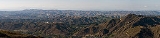
The Simi Hills are a low rocky mountain range
of the Transverse Ranges
, located in eastern Ventura County
and western Los Angeles County
, of southern California
, United States
.
. They run east-west and they extend 26 miles (41.8 km) east-west, and 7 mi (11.3 km) north-south. The Simi Hills are part of the Transverse Ranges
. They are almost entirely in Ventura County, the foothills in the south and east are part of Los Angeles County
. Simi Valley
lies to the north, and Chatsworth
lies to the east, over the border in Los Angeles city
and county
. The Conejo Valley
lies to the south. Nearby mountain ranges include: the higher Santa Susana
(north, across the Santa Susana Pass
); and Santa Monica
(south) mountains. The Simi Hills are the most critical habitat and wildlife corridor
linkage between the Santa Monica Mountains
and the Santa Susana Mountains
, Topatopa Mountains
, and San Gabriel Mountains
. Las Virgenes Creek, Bell Creek
, Dayton Creek, Runkle Canyon Creek, Woolsey Canyon Creek, and Arroyo Calabasas
are some of the watersheds in the Simi Hills.
y, mild winters. Snow
is rare in the Simi Hills, even in the highest areas. Summers are warm and dry and wildfire
s do occur here. Cool winds from the Pacific Ocean come from the Oxnard Plain
and blow into the inland areas through the Santa Clara River Valley
and the Conejo Valley
, though some low hills, such as Conejo Mountain, block these winds from the Conejo Valley. The Simi Hills further block these winds, which bring cool weather in both summer and winter from the San Fernando Valley
.
(2,403 ft (732 m)), Chatsworth Peak
(2,314 ft (700 m)), and Escorpión Peak
(aka: Castle Peak) (1,475 ft (450 m)).
s and oak
savanna. The northern rocky hills area is primarily Chaparral
shrubland
and oak woodlands
. The Simi Hills are part of the California chaparral and woodlands
ecoregion
. The Oaks (Quercus spp.) include: the evergreen
Coast Live Oak
(Quercus agrifolia), the deciduous
Valley Oak
(Quercus lobata), and the Scrub Oak
(Quercus dumosa). Riparian zone
plants include California Sycamores (Platanus racemosa) and Arroyo willow
s (Salix lasiolepis). Spring wildflower
s include the Redbush Monkey Flower
(Mimulus aurantiacus), Plummer's Mariposa Lily
(Calochortus plummerae), and Canyon Sunflower
(Encelia californica). Poison Oak (Toxicodendron diversilobum) is also an important member of the native plant habitat
community here.
with the inland Santa Susana Mountains
, Topatopa Mountains
, and San Gabriel Mountains
, all of the transverse ranges fauna community.
for settlements and hunting grounds. The Chumash had the established village of Hu'wam in Cañon del Escorpión (Bell Canyon). It was a multicultural 'crossroads' destination, where Chumash, Tongva, and Tataviam
peoples traded and lived beside Bell Creek
below Escorpión Peak
, at the present day Bell Canyon Park
. This peak in the Simi Hills (aka: Castle Peak) is one of nine alignment points in Chumash territory and is essential to maintaining the balance of the natural world. Upstream were healing springs and are rock outcrop 'grinding stones.' The Burro Flats Painted Cave
, an example of the Rock art of the Chumash people
, is nearby.
The Juan Bautista de Anza expedition passed through the area in 1769, being the first European sighting of the Simi Hills. The U.S. National Park Service
administers the Juan Bautista de Anza National Historic Trail
which enters at Moore Canyon in El Escorpión Park
and crosses across the southern Hills through Upper Las Virgenes Canyon Open Space Preserve
and Cheeseboro/Palo Comado Canyon Park to the Conejo Valley
. In 1845 the land grant
for Rancho El Escorpión
, beside the Peak and named for it, was issued to one Chumash and two Tongva people and a rare instance of Native Americans being grantees, by Mexican Governor Pío Pico
. The Rancho El Conejo
was to the west, and included that end of the Simi Hills.
In the first half of the 20th century there were four large movie ranch
es in the Simi Hills for filming motion pictures on location. The gated community of Bell Canyon
began development of geographic Bell Canyon in the 1968. To the north of U.S. 101, east of Thousand Oaks
, and west of Simi Valley
the early 1960s further suburban expansion of metropolitan Los Angeles brought small to significant parcels in the Simi Hills under development. Hillside subdivisions regraded natural contours into terraced lots, changing the Hills viewshed, drainage patterns, and habitats in those areas. The extensive planned new community projects at Jordan Ranch and Ahmanson Ranch were eventually stopped by local citizens and the Santa Monica Mountains Conservancy
keeping extensive Hills acreage natural in open space parks.
The Simi Hills were home of the Rocketdyne
Santa Susana Field Laboratory
(SSFL) for open-air testing of rocket engines from 1947 to 1990, and the site of an experimental nuclear reactor
experiments, one having meltdown accident in 1959. The groundwater under portions of the Simi Hills, contaminated with toxins and radionuclides that were also historically used at SSFL, has been and are a key concern in new development decisions and the SSFL property's future limited to parkland use after an impending cleanup, initiating preservation of more open space in the range.
The NPS Rim of the Valley Trail Corridor is in the planning stages and includes the Simi Hills open space parklands and proposed new areas.
Mountain range
A mountain range is a single, large mass consisting of a succession of mountains or narrowly spaced mountain ridges, with or without peaks, closely related in position, direction, formation, and age; a component part of a mountain system or of a mountain chain...
of the Transverse Ranges
Transverse Ranges
The Transverse Ranges are a group of mountain ranges of southern California, in the Pacific Coast Ranges physiographic region that runs along the Pacific coast from Alaska to Mexico in North America. The Transverse Ranges begin at the southern end of the California Coast Ranges and lie between...
, located in eastern Ventura County
Ventura County, California
Ventura County is a county in the southern part of the U.S. state of California. It is located on California's Pacific coast. It is often referred to as the Gold Coast, and has a reputation of being one of the safest populated places and one of the most affluent places in the country...
and western Los Angeles County
Los Angeles County, California
Los Angeles County is a county in the U.S. state of California. As of 2010 U.S. Census, the county had a population of 9,818,605, making it the most populous county in the United States. Los Angeles County alone is more populous than 42 individual U.S. states...
, of southern California
California
California is a state located on the West Coast of the United States. It is by far the most populous U.S. state, and the third-largest by land area...
, United States
United States
The United States of America is a federal constitutional republic comprising fifty states and a federal district...
.
Geography
The Simi Hills are located on the western edge of the San Fernando ValleySan Fernando Valley
The San Fernando Valley is an urbanized valley located in the Los Angeles metropolitan area of southern California, United States, defined by the dramatic mountains of the Transverse Ranges circling it...
. They run east-west and they extend 26 miles (41.8 km) east-west, and 7 mi (11.3 km) north-south. The Simi Hills are part of the Transverse Ranges
Transverse Ranges
The Transverse Ranges are a group of mountain ranges of southern California, in the Pacific Coast Ranges physiographic region that runs along the Pacific coast from Alaska to Mexico in North America. The Transverse Ranges begin at the southern end of the California Coast Ranges and lie between...
. They are almost entirely in Ventura County, the foothills in the south and east are part of Los Angeles County
Los Angeles County, California
Los Angeles County is a county in the U.S. state of California. As of 2010 U.S. Census, the county had a population of 9,818,605, making it the most populous county in the United States. Los Angeles County alone is more populous than 42 individual U.S. states...
. Simi Valley
Simi Valley, California
-2010:The 2010 United States Census reported that Simi Valley had a population of 124,237. The population density was 2,940.8 people per square mile...
lies to the north, and Chatsworth
Chatsworth, Los Angeles, California
Chatsworth is a district of Los Angeles, California, United States; in the northwestern San Fernando Valley. The district is bordered by the Santa Susana Mountains and unincorporated Los Angeles County lands to the north, Porter Ranch to the northeast, Northridge to the east, West Hills, Canoga...
lies to the east, over the border in Los Angeles city
Los Angeles, California
Los Angeles , with a population at the 2010 United States Census of 3,792,621, is the most populous city in California, USA and the second most populous in the United States, after New York City. It has an area of , and is located in Southern California...
and county
Los Angeles County, California
Los Angeles County is a county in the U.S. state of California. As of 2010 U.S. Census, the county had a population of 9,818,605, making it the most populous county in the United States. Los Angeles County alone is more populous than 42 individual U.S. states...
. The Conejo Valley
Conejo Valley
The Conejo Valley is a region spanning both southeastern Ventura County and northwestern Los Angeles County in Southern California, United States...
lies to the south. Nearby mountain ranges include: the higher Santa Susana
Santa Susana Mountains
The Santa Susana Mountains are a transverse range of mountains in southern California, north of the city of Los Angeles, in the United States. The range runs east-west separating the San Fernando Valley and Simi Valley on its south, from Santa Clara River Valley to the north, and Santa Clarita...
(north, across the Santa Susana Pass
Santa Susana Pass
The Santa Susana Pass is a Southern California mountain pass in the Simi Hills connecting the San Fernando Valley and town of Chatsworth, to the Simi Valley and city of Simi Valley.-Natural history:...
); and Santa Monica
Santa Monica Mountains
The Santa Monica Mountains are a Transverse Range in Southern California, along the coast of the Pacific Ocean in the United States.-Geography:...
(south) mountains. The Simi Hills are the most critical habitat and wildlife corridor
Wildlife corridor
A wildlife corridor or green corridor is an area of habitat connecting wildlife populations separated by human activities . This allows an exchange of individuals between populations, which may help prevent the negative effects of inbreeding and reduced genetic diversity that often occur within...
linkage between the Santa Monica Mountains
Santa Monica Mountains
The Santa Monica Mountains are a Transverse Range in Southern California, along the coast of the Pacific Ocean in the United States.-Geography:...
and the Santa Susana Mountains
Santa Susana Mountains
The Santa Susana Mountains are a transverse range of mountains in southern California, north of the city of Los Angeles, in the United States. The range runs east-west separating the San Fernando Valley and Simi Valley on its south, from Santa Clara River Valley to the north, and Santa Clarita...
, Topatopa Mountains
Topatopa Mountains
The Topatopa Mountains are a mountain range in Ventura County, California, north of Santa Paula. They are part of the Transverse Ranges of Southern California. The range lies in an east-west direction northeast of the community of Ojai, and west of the Sespe Condor Sanctuary. The ranges reaches an...
, and San Gabriel Mountains
San Gabriel Mountains
The San Gabriel Mountains Range is located in northern Los Angeles County and western San Bernardino County, California, United States. The mountain range lies between the Los Angeles Basin and the Mojave Desert, with Interstate 5 to the west and Interstate 15 to the east...
. Las Virgenes Creek, Bell Creek
Bell Creek (Southern California)
Bell Creek is a tributary of the Los Angeles River, in the Simi Hills of Ventura County and the San Fernando Valley of Los Angeles County and City, in Southern California.-Route:...
, Dayton Creek, Runkle Canyon Creek, Woolsey Canyon Creek, and Arroyo Calabasas
Arroyo Calabasas
Arroyo Calabasas is a tributary of the Los Angeles River, in the southwestern San Fernando Valley area of Los Angeles County in California.-Route:...
are some of the watersheds in the Simi Hills.
Climate
Because of its low elevation, the Simi Hills typically experience rainRain
Rain is liquid precipitation, as opposed to non-liquid kinds of precipitation such as snow, hail and sleet. Rain requires the presence of a thick layer of the atmosphere to have temperatures above the melting point of water near and above the Earth's surface...
y, mild winters. Snow
Snow
Snow is a form of precipitation within the Earth's atmosphere in the form of crystalline water ice, consisting of a multitude of snowflakes that fall from clouds. Since snow is composed of small ice particles, it is a granular material. It has an open and therefore soft structure, unless packed by...
is rare in the Simi Hills, even in the highest areas. Summers are warm and dry and wildfire
Wildfire
A wildfire is any uncontrolled fire in combustible vegetation that occurs in the countryside or a wilderness area. Other names such as brush fire, bushfire, forest fire, desert fire, grass fire, hill fire, squirrel fire, vegetation fire, veldfire, and wilkjjofire may be used to describe the same...
s do occur here. Cool winds from the Pacific Ocean come from the Oxnard Plain
Oxnard Plain
The Oxnard Plain is a large coastal plain in southwest Ventura County, California bounded by the Santa Monica Mountains, the Santa Susana Mountains, and Oak Ridge to the east, the Topatopa Mountains to the north, the Santa Clara River Valley to the northeast and the Pacific Ocean to the south and...
and blow into the inland areas through the Santa Clara River Valley
Santa Clara River Valley
The Santa Clara River Valley is a valley that runs from east to west through Ventura County and northwest Los Angeles County, California...
and the Conejo Valley
Conejo Valley
The Conejo Valley is a region spanning both southeastern Ventura County and northwestern Los Angeles County in Southern California, United States...
, though some low hills, such as Conejo Mountain, block these winds from the Conejo Valley. The Simi Hills further block these winds, which bring cool weather in both summer and winter from the San Fernando Valley
San Fernando Valley
The San Fernando Valley is an urbanized valley located in the Los Angeles metropolitan area of southern California, United States, defined by the dramatic mountains of the Transverse Ranges circling it...
.
Peaks
Peaks in this region include Simi PeakSimi Peak
Simi Peak is a peak in the Simi Hills in Southern California. It is the highest peak in the Simi Hills, at 2,403 feet .-Geography:Simi Peak is located in eastern Ventura County, California, near the cities of Simi Valley, California to the north, and Thousand Oaks, California to the west.-Nearby...
(2,403 ft (732 m)), Chatsworth Peak
Chatsworth Peak
Chatsworth Peak is a peak in the Simi Hills overlooking Chatsworth, California on the east. Is southwest of Santa Susana Pass and north of the Chatsworth Reservoir at an elevation of ....
(2,314 ft (700 m)), and Escorpión Peak
El Escorpion Park
El Escorpión Park is a three-acre park located in the Simi Hills of the western San Fernando Valley, in the West Hills district of Los Angeles, California...
(aka: Castle Peak) (1,475 ft (450 m)).
Flora
The southern lower hills are mostly covered in grasslandGrassland
Grasslands are areas where the vegetation is dominated by grasses and other herbaceous plants . However, sedge and rush families can also be found. Grasslands occur naturally on all continents except Antarctica...
s and oak
Oak
An oak is a tree or shrub in the genus Quercus , of which about 600 species exist. "Oak" may also appear in the names of species in related genera, notably Lithocarpus...
savanna. The northern rocky hills area is primarily Chaparral
Chaparral
Chaparral is a shrubland or heathland plant community found primarily in the U.S. state of California and in the northern portion of the Baja California peninsula, Mexico...
shrubland
Shrubland
Shrubland, scrubland, scrub or brush is a plant community characterized by vegetation dominated by shrubs, often also including grasses, herbs, and geophytes. Shrubland may either occur naturally or be the result of human activity...
and oak woodlands
California oak woodland
California oak woodland is a plant community found throughout the California chaparral and woodlands ecoregion of California in the United States and northwestern Baja California in Mexico...
. The Simi Hills are part of the California chaparral and woodlands
California chaparral and woodlands
The California chaparral and woodlands is a terrestrial ecoregion of lower northern, central, and southern California and northwestern Baja California , located on the west coast of North America...
ecoregion
Ecoregion
An ecoregion , sometimes called a bioregion, is an ecologically and geographically defined area that is smaller than an ecozone and larger than an ecosystem. Ecoregions cover relatively large areas of land or water, and contain characteristic, geographically distinct assemblages of natural...
. The Oaks (Quercus spp.) include: the evergreen
Evergreen
In botany, an evergreen plant is a plant that has leaves in all seasons. This contrasts with deciduous plants, which completely lose their foliage during the winter or dry season.There are many different kinds of evergreen plants, both trees and shrubs...
Coast Live Oak
Coast Live Oak
Quercus agrifolia, the Coast Live Oak, is an evergreen oak , native to the California Floristic Province. It grows west of the Sierra Nevada from Mendocino County, California, south to northern Baja California in Mexico. It is classified in the red oak section Quercus agrifolia, the Coast Live Oak,...
(Quercus agrifolia), the deciduous
Deciduous
Deciduous means "falling off at maturity" or "tending to fall off", and is typically used in reference to trees or shrubs that lose their leaves seasonally, and to the shedding of other plant structures such as petals after flowering or fruit when ripe...
Valley Oak
Valley Oak
Quercus lobata, commonly called the Valley oak, grows into the largest of North American oaks. It is endemic to California, growing in the interior valleys and foothills. Mature specimens may attain an age of up to 600 years. This deciduous oak requires year-round access to groundwater.Its thick,...
(Quercus lobata), and the Scrub Oak
Scrub Oak
Scrub Oak is a general name for several species of small, shrubby oaks, including the following species:*California Scrub Oak *Leather Oak *Coastal Scrub Oak...
(Quercus dumosa). Riparian zone
Riparian zone
A riparian zone or riparian area is the interface between land and a river or stream. Riparian is also the proper nomenclature for one of the fifteen terrestrial biomes of the earth. Plant habitats and communities along the river margins and banks are called riparian vegetation, characterized by...
plants include California Sycamores (Platanus racemosa) and Arroyo willow
Salix lasiolepis
Salix lasiolepis is a species of willow native to western and southwestern North America, in the United States from central and southern Washington and southwestern Idaho south to California and Texas, and in Mexico from the Baja California peninsula east to Coahuila and south to Jalisco. The name...
s (Salix lasiolepis). Spring wildflower
Wildflower
A wildflower is a flower that grows wild, meaning it was not intentionally seeded or planted. Yet "wildflower" meadows of a few mixed species are sold in seed packets. The term "wildflower" has been made vague by commercial seedsmen who are interested in selling more flowers or seeds more...
s include the Redbush Monkey Flower
Mimulus aurantiacus
Mimulus aurantiacus, the Sticky monkey-flower and Orange bush monkey-flower, is a flowering plant that grows in a subshrub form, native to southwestern North America from southwestern Oregon south through most of California...
(Mimulus aurantiacus), Plummer's Mariposa Lily
Calochortus plummerae
Calochortus plummerae is a species of mariposa lily known by the common name Plummer's mariposa lily. It is endemic to Southern California where it is found along the coast and inland hills. It is a member of the chaparral plant community. It produces thin, branching stems and a few long curling...
(Calochortus plummerae), and Canyon Sunflower
Encelia californica
Encelia californica is a species of flowering plant in the daisy family known by the common name California brittlebush. It is also commonly referred to as "California bush sunflower"....
(Encelia californica). Poison Oak (Toxicodendron diversilobum) is also an important member of the native plant habitat
California native plants
California native plants are plants that existed in California prior to the arrival of European explorers and colonists in the late 18th century...
community here.
Fauna
The Simi Hills is the principal, and much wider, of only two terrestrial wildlife corridors linking the coastal Santa Monica MountainsSanta Monica Mountains
The Santa Monica Mountains are a Transverse Range in Southern California, along the coast of the Pacific Ocean in the United States.-Geography:...
with the inland Santa Susana Mountains
Santa Susana Mountains
The Santa Susana Mountains are a transverse range of mountains in southern California, north of the city of Los Angeles, in the United States. The range runs east-west separating the San Fernando Valley and Simi Valley on its south, from Santa Clara River Valley to the north, and Santa Clarita...
, Topatopa Mountains
Topatopa Mountains
The Topatopa Mountains are a mountain range in Ventura County, California, north of Santa Paula. They are part of the Transverse Ranges of Southern California. The range lies in an east-west direction northeast of the community of Ojai, and west of the Sespe Condor Sanctuary. The ranges reaches an...
, and San Gabriel Mountains
San Gabriel Mountains
The San Gabriel Mountains Range is located in northern Los Angeles County and western San Bernardino County, California, United States. The mountain range lies between the Los Angeles Basin and the Mojave Desert, with Interstate 5 to the west and Interstate 15 to the east...
, all of the transverse ranges fauna community.
Human History
The Simi Hills were inhabited for over 8,000 years by Paleo-indians and Chumash-Venturaño Native AmericansNative Americans in the United States
Native Americans in the United States are the indigenous peoples in North America within the boundaries of the present-day continental United States, parts of Alaska, and the island state of Hawaii. They are composed of numerous, distinct tribes, states, and ethnic groups, many of which survive as...
for settlements and hunting grounds. The Chumash had the established village of Hu'wam in Cañon del Escorpión (Bell Canyon). It was a multicultural 'crossroads' destination, where Chumash, Tongva, and Tataviam
Tataviam
The Tataviam , were called the Alliklik by their neighbors the Chumash , are a Native American group in southern California...
peoples traded and lived beside Bell Creek
Bell Creek (Southern California)
Bell Creek is a tributary of the Los Angeles River, in the Simi Hills of Ventura County and the San Fernando Valley of Los Angeles County and City, in Southern California.-Route:...
below Escorpión Peak
El Escorpion Park
El Escorpión Park is a three-acre park located in the Simi Hills of the western San Fernando Valley, in the West Hills district of Los Angeles, California...
, at the present day Bell Canyon Park
Bell Canyon Park
Bell Canyon Park is a large open-space regional park located in the Simi Hills at the western end of the San Fernando Valley in West Hills and Bell Canyon, California. Bell Creek, a primary tributary to the Los Angeles River, flows through the park with riparian zone vegetation along its natural...
. This peak in the Simi Hills (aka: Castle Peak) is one of nine alignment points in Chumash territory and is essential to maintaining the balance of the natural world. Upstream were healing springs and are rock outcrop 'grinding stones.' The Burro Flats Painted Cave
Burro Flats Painted Cave
Burro Flats Painted Cave is in the Burro Flats area of the Simi Hills, located between the Simi Valley, and West Hills and Bell Canyon, in Ventura County of Southern California, United States. It is a Cave containing Chumash Native American pictographs...
, an example of the Rock art of the Chumash people
Rock art of the Chumash people
Chumash rock art is a genre of paintings on caves, mountains, cliffs, or other living rock surfaces, created by the Chumash people of southern California. Pictographs and petroglyphs are common through interior California, the rock painting tradition thrived until the 19th century...
, is nearby.
The Juan Bautista de Anza expedition passed through the area in 1769, being the first European sighting of the Simi Hills. The U.S. National Park Service
National Park Service
The National Park Service is the U.S. federal agency that manages all national parks, many national monuments, and other conservation and historical properties with various title designations...
administers the Juan Bautista de Anza National Historic Trail
Juan Bautista de Anza National Historic Trail
thumb|325px|MAP: [[Juan Bautista de Anza]] National Historic Trail routes in [[Arizona]] and [[California]].The Juan Bautista de Anza National Historic Trail is a National Park Service unit in the United States National Historic Trail and National Millennium Trail programs...
which enters at Moore Canyon in El Escorpión Park
El Escorpion Park
El Escorpión Park is a three-acre park located in the Simi Hills of the western San Fernando Valley, in the West Hills district of Los Angeles, California...
and crosses across the southern Hills through Upper Las Virgenes Canyon Open Space Preserve
Upper Las Virgenes Canyon Open Space Preserve
The Upper Las Virgenes Canyon Open Space Preserve is a large open space nature preserve owned and operated by the Santa Monica Mountains Conservancy spanning nearly in the Simi Hills of western Los Angeles County and eastern Ventura County....
and Cheeseboro/Palo Comado Canyon Park to the Conejo Valley
Conejo Valley
The Conejo Valley is a region spanning both southeastern Ventura County and northwestern Los Angeles County in Southern California, United States...
. In 1845 the land grant
Land grant
A land grant is a gift of real estate – land or its privileges – made by a government or other authority as a reward for services to an individual, especially in return for military service...
for Rancho El Escorpión
Rancho El Escorpión
Rancho El Escorpión was a Mexican land grant in present day Los Angeles County, California given in 1845 by Governor Pío Pico to three Chumash Native Americans - Odón Eusebia, Urbano, and Mañuel....
, beside the Peak and named for it, was issued to one Chumash and two Tongva people and a rare instance of Native Americans being grantees, by Mexican Governor Pío Pico
Pío Pico
Pío de Jesús Pico was the last Governor of Alta California under Mexican rule.-Origins:...
. The Rancho El Conejo
Rancho El Conejo
Rancho El Conejo was a Spanish land grant in California given in 1803 to Jose Polanco and Ygnacio Rodriguez that encompassed the area now known as the Conejo Valley in southeastern Ventura and northwestern Los Angeles Counties. El Conejo means "The Rabbit" in Spanish, and refers to the many...
was to the west, and included that end of the Simi Hills.
In the first half of the 20th century there were four large movie ranch
Movie ranch
A movie ranch is a ranch that is at least partially dedicated to being used as a site for the creation and production of motion pictures, and television productions...
es in the Simi Hills for filming motion pictures on location. The gated community of Bell Canyon
Bell Canyon, California
Bell Canyon is a census-designated place in Ventura County, California. Bell Canyon is a residential unincorporated community located near West Hills and the western San Fernando Valley in the Simi Hills. Although only minutes from the Los Angeles city limits, Bell Canyon is a Horse Community. ...
began development of geographic Bell Canyon in the 1968. To the north of U.S. 101, east of Thousand Oaks
Thousand Oaks, California
Thousand Oaks is a city in southeastern Ventura County, California, in the United States. It was named after the many oak trees that grace the area, and the city seal is adorned with an oak....
, and west of Simi Valley
Simi Valley, California
-2010:The 2010 United States Census reported that Simi Valley had a population of 124,237. The population density was 2,940.8 people per square mile...
the early 1960s further suburban expansion of metropolitan Los Angeles brought small to significant parcels in the Simi Hills under development. Hillside subdivisions regraded natural contours into terraced lots, changing the Hills viewshed, drainage patterns, and habitats in those areas. The extensive planned new community projects at Jordan Ranch and Ahmanson Ranch were eventually stopped by local citizens and the Santa Monica Mountains Conservancy
Santa Monica Mountains Conservancy
The Santa Monica Mountains Conservancy is an agency of the state of California in the United States founded in 1980 and dedicated to the acquisition of land for preservation as open space, for wildlife and California native plants habitat Nature Preserves, and for public recreation...
keeping extensive Hills acreage natural in open space parks.
The Simi Hills were home of the Rocketdyne
Rocketdyne
Rocketdyne was a Rocket engine design and production company headquartered in Canoga Park, California, United States. The company was related to North American Aviation for most of its history. NAA merged with Rockwell International, which was then bought by Boeing in December, 1996...
Santa Susana Field Laboratory
Santa Susana Field Laboratory
The Santa Susana Field Laboratory is a complex of industrial research and development facilities located on a 2,668 acre portion of the Southern California Simi Hills in Simi Valley, California, used mainly for the testing and development of Liquid-propellant rocket engines for the United States...
(SSFL) for open-air testing of rocket engines from 1947 to 1990, and the site of an experimental nuclear reactor
Sodium Reactor Experiment
The Sodium Reactor Experiment was a pioneering nuclear power plant built by Atomics International at the Santa Susana Field Laboratory, nearby Simi Valley, California. The reactor operated from 1957 to 1964...
experiments, one having meltdown accident in 1959. The groundwater under portions of the Simi Hills, contaminated with toxins and radionuclides that were also historically used at SSFL, has been and are a key concern in new development decisions and the SSFL property's future limited to parkland use after an impending cleanup, initiating preservation of more open space in the range.
The NPS Rim of the Valley Trail Corridor is in the planning stages and includes the Simi Hills open space parklands and proposed new areas.
Parks
- Upper Las Virgenes Canyon Open Space PreserveUpper Las Virgenes Canyon Open Space PreserveThe Upper Las Virgenes Canyon Open Space Preserve is a large open space nature preserve owned and operated by the Santa Monica Mountains Conservancy spanning nearly in the Simi Hills of western Los Angeles County and eastern Ventura County....
- (previously the Ahmanson Ranch Park), 3,000 acres (12 km²) Park in the southern Simi Hills, managed by the Santa Monica Mountains ConservancySanta Monica Mountains ConservancyThe Santa Monica Mountains Conservancy is an agency of the state of California in the United States founded in 1980 and dedicated to the acquisition of land for preservation as open space, for wildlife and California native plants habitat Nature Preserves, and for public recreation...
. - The Santa Susana Pass State Historic ParkSanta Susana Pass State Historic ParkSanta Susana Pass State Historic Park is a California State Park of approximately located on the boundary between Ventura and Los Angeles Counties, between the communities of Chatsworth and Simi Valley. Geologically, the park is located where Simi Hills meet the Santa Susana Mountains...
- with the Old Santa Susana Stage Road in the rocky northern Simi Hills. - Sage Ranch Park - higher in the hills, is near the Santa Susana Field LaboratorySanta Susana Field LaboratoryThe Santa Susana Field Laboratory is a complex of industrial research and development facilities located on a 2,668 acre portion of the Southern California Simi Hills in Simi Valley, California, used mainly for the testing and development of Liquid-propellant rocket engines for the United States...
, and has with trails and camping. - Cheeseboro/Palo Comado Canyon Park - in the Santa Monica Mountains National Recreation AreaSanta Monica Mountains National Recreation AreaThe Santa Monica Mountains National Recreation Area or SMMNRA, is a United States National Recreation Area containing many individual parks and open space preserves, located primarily in the Santa Monica Mountains of Southern California...
, western Simi Hills in Ventura CountyVentura County, CaliforniaVentura County is a county in the southern part of the U.S. state of California. It is located on California's Pacific coast. It is often referred to as the Gold Coast, and has a reputation of being one of the safest populated places and one of the most affluent places in the country...
. - El Escorpión ParkEl Escorpion ParkEl Escorpión Park is a three-acre park located in the Simi Hills of the western San Fernando Valley, in the West Hills district of Los Angeles, California...
and the Moore's Canyon Juan Bautista de Anza National Historic TrailJuan Bautista de Anza National Historic Trailthumb|325px|MAP: [[Juan Bautista de Anza]] National Historic Trail routes in [[Arizona]] and [[California]].The Juan Bautista de Anza National Historic Trail is a National Park Service unit in the United States National Historic Trail and National Millennium Trail programs...
segment; West Hills, Los Angeles - Bell Canyon ParkBell Canyon ParkBell Canyon Park is a large open-space regional park located in the Simi Hills at the western end of the San Fernando Valley in West Hills and Bell Canyon, California. Bell Creek, a primary tributary to the Los Angeles River, flows through the park with riparian zone vegetation along its natural...
with Bell CreekBell Creek (Southern California)Bell Creek is a tributary of the Los Angeles River, in the Simi Hills of Ventura County and the San Fernando Valley of Los Angeles County and City, in Southern California.-Route:...
; West Hills and Bell CanyonBell Canyon, CaliforniaBell Canyon is a census-designated place in Ventura County, California. Bell Canyon is a residential unincorporated community located near West Hills and the western San Fernando Valley in the Simi Hills. Although only minutes from the Los Angeles city limits, Bell Canyon is a Horse Community. ... - The museum at the Ronald Reagan Presidential LibraryRonald Reagan Presidential LibraryThe Ronald Reagan Presidential Library and Center for Public Affairs is the presidential library and final resting place of Ronald Wilson Reagan, the 40th President of the United States. Designed by Hugh Stubbins and Associates, the library is located in Simi Valley, California, about northwest of...
complex, Simi Valley, CaliforniaSimi Valley, California-2010:The 2010 United States Census reported that Simi Valley had a population of 124,237. The population density was 2,940.8 people per square mile... - Rocky Peak ParkRocky peakRocky Peak, located in Rocky Peak Park, is the third-highest point in the Santa Susana Mountains, and overlooks the San Fernando Valley and Chatsworth, the Simi Hills, and the Simi Valley in Southern California...
- adjacent above Santa Susana PassSanta Susana PassThe Santa Susana Pass is a Southern California mountain pass in the Simi Hills connecting the San Fernando Valley and town of Chatsworth, to the Simi Valley and city of Simi Valley.-Natural history:...
Nearby ranges
- Chalk HillsChalk HillsThe Chalk Hills are a north—south running low 'mountain' range in the San Fernando Valley perpendicular to and adjoining the Santa Monica Mountains. They are located in the Woodland Hills District of the City of Los Angeles in Southern California.-Environs:...
- Santa Susana MountainsSanta Susana MountainsThe Santa Susana Mountains are a transverse range of mountains in southern California, north of the city of Los Angeles, in the United States. The range runs east-west separating the San Fernando Valley and Simi Valley on its south, from Santa Clara River Valley to the north, and Santa Clarita...
- Santa Monica MountainsSanta Monica MountainsThe Santa Monica Mountains are a Transverse Range in Southern California, along the coast of the Pacific Ocean in the United States.-Geography:...
- Verdugo MountainsVerdugo MountainsThe Verdugo Mountains are a small, rugged mountain range of the Transverse Ranges system, located just south of the western San Gabriel Mountains in Los Angeles County, Southern California...
See also
- Burro Flats Painted CaveBurro Flats Painted CaveBurro Flats Painted Cave is in the Burro Flats area of the Simi Hills, located between the Simi Valley, and West Hills and Bell Canyon, in Ventura County of Southern California, United States. It is a Cave containing Chumash Native American pictographs...
- Bell CreekBell Creek (Southern California)Bell Creek is a tributary of the Los Angeles River, in the Simi Hills of Ventura County and the San Fernando Valley of Los Angeles County and City, in Southern California.-Route:...
- Rancho El EscorpiónRancho El EscorpiónRancho El Escorpión was a Mexican land grant in present day Los Angeles County, California given in 1845 by Governor Pío Pico to three Chumash Native Americans - Odón Eusebia, Urbano, and Mañuel....
External links
- Santa Monica Mountains Conservancy: Park-Finder interactive website.
- U.S.NPS-Santa Monica Mountains National Recreation Area: official NPS local Park-Finder interactive website.
- SMMC_Sage Ranch Park-NE Simi Hills Trails Map
- Ventura County Trails.org_Escorpión Peak (SE Simi Hills) Photos +trails map
- Ventura County Trails.org_Cheeseboro-Palo Commado (SW Simi Hills) Photos + trails maps
- Ventura County Trails.org_Wood+Lang Ranches-Regional Parks (NW Simi Hills) Photos + trails maps