
.gif)
Drainage system (Geomorphology)
Encyclopedia
In geomorphology
, a drainage system is the pattern formed by the stream
s, river
s, and lake
s in a particular drainage basin
. They are governed by the topography of the land, whether a particular region is dominated by hard or soft rocks, and the gradient of the land. Geomorphologists and hydrologists often view streams as being part of drainage basins. A drainage basin is the topographic region from which a stream receives runoff, throughflow, and groundwater flow. Drainage basins are divided from each other by topographic barriers called a watershed. A watershed represents all of the stream tributaries that flow to some location along the stream channel. The number, size, and shape of the drainage basins found in an area varies and the larger the topographic map
, the more information on the drainage basin is available.
and geology
of the land:
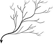

, dendrites, "of or pertaining to a tree") are the most common form of drainage system. In a dendritic system, there are many contributing streams (analogous to the twigs of a tree), which are then joined together into the tributaries of the main river (the branches and the trunk of the tree, respectively). They develop where the river channel follows the slope of the terrain. Dendritic systems form in V-shaped valleys; as a result, the rock types must be impervious and non-porous.
. Because of the steep slopes, the streams are swift and straight, with very few tributaries, and all flow in the same direction. This system forms on uniformly sloping surfaces, for example, rivers flowing southeast from the Aberdare Mountains in Kenya.
in North America.
s usually display excellent radial drainage. Other geological features on which radial drainage commonly develops are domes
and laccolith
s. On these features the drainage may exhibit a combination of radial and annular patterns.
s where there is no coherent pattern to the rivers and lakes. It happens in areas where there has been much geological disruption. The classic example is the Canadian Shield
. During the last ice age
, the topsoil was scraped off, leaving mostly bare rock. The melting of the glaciers left land with many irregularities of elevation, and a great deal of water to collect in the low points, explaining the large number of lakes which are found in Canada. The watersheds are young and are still sorting themselves out. Eventually the system will stabilize.
of South Dakota
.
Geomorphology
Geomorphology is the scientific study of landforms and the processes that shape them...
, a drainage system is the pattern formed by the stream
Stream
A stream is a body of water with a current, confined within a bed and stream banks. Depending on its locale or certain characteristics, a stream may be referred to as a branch, brook, beck, burn, creek, "crick", gill , kill, lick, rill, river, syke, bayou, rivulet, streamage, wash, run or...
s, river
River
A river is a natural watercourse, usually freshwater, flowing towards an ocean, a lake, a sea, or another river. In a few cases, a river simply flows into the ground or dries up completely before reaching another body of water. Small rivers may also be called by several other names, including...
s, and lake
Lake
A lake is a body of relatively still fresh or salt water of considerable size, localized in a basin, that is surrounded by land. Lakes are inland and not part of the ocean and therefore are distinct from lagoons, and are larger and deeper than ponds. Lakes can be contrasted with rivers or streams,...
s in a particular drainage basin
Drainage basin
A drainage basin is an extent or an area of land where surface water from rain and melting snow or ice converges to a single point, usually the exit of the basin, where the waters join another waterbody, such as a river, lake, reservoir, estuary, wetland, sea, or ocean...
. They are governed by the topography of the land, whether a particular region is dominated by hard or soft rocks, and the gradient of the land. Geomorphologists and hydrologists often view streams as being part of drainage basins. A drainage basin is the topographic region from which a stream receives runoff, throughflow, and groundwater flow. Drainage basins are divided from each other by topographic barriers called a watershed. A watershed represents all of the stream tributaries that flow to some location along the stream channel. The number, size, and shape of the drainage basins found in an area varies and the larger the topographic map
Topographic map
A topographic map is a type of map characterized by large-scale detail and quantitative representation of relief, usually using contour lines in modern mapping, but historically using a variety of methods. Traditional definitions require a topographic map to show both natural and man-made features...
, the more information on the drainage basin is available.
Types of drainage system
Drainage systems can fall into one of several categories, depending on the topographyTopography
Topography is the study of Earth's surface shape and features or those ofplanets, moons, and asteroids...
and geology
Geology
Geology is the science comprising the study of solid Earth, the rocks of which it is composed, and the processes by which it evolves. Geology gives insight into the history of the Earth, as it provides the primary evidence for plate tectonics, the evolutionary history of life, and past climates...
of the land:
Dendritic drainage system
Dendritic drainage systems (from GreekGreek language
Greek is an independent branch of the Indo-European family of languages. Native to the southern Balkans, it has the longest documented history of any Indo-European language, spanning 34 centuries of written records. Its writing system has been the Greek alphabet for the majority of its history;...
, dendrites, "of or pertaining to a tree") are the most common form of drainage system. In a dendritic system, there are many contributing streams (analogous to the twigs of a tree), which are then joined together into the tributaries of the main river (the branches and the trunk of the tree, respectively). They develop where the river channel follows the slope of the terrain. Dendritic systems form in V-shaped valleys; as a result, the rock types must be impervious and non-porous.
Parallel drainage system
A parallel drainage system is a pattern of rivers caused by steep slopes with some reliefTerrain
Terrain, or land relief, is the vertical and horizontal dimension of land surface. When relief is described underwater, the term bathymetry is used...
. Because of the steep slopes, the streams are swift and straight, with very few tributaries, and all flow in the same direction. This system forms on uniformly sloping surfaces, for example, rivers flowing southeast from the Aberdare Mountains in Kenya.
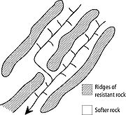
Trellis drainage system
The geometry of a trellis drainage system is similar to that of a common garden trellis used to grow vines. As the river flows along a strike valley, smaller tributaries feed into it from the steep slopes on the sides of mountains. These tributaries enter the main river at approximately 90 degree angles, causing a trellis-like appearance of the drainage system. Trellis drainage is characteristic of folded mountains, such as the Appalachian MountainsAppalachian Mountains
The Appalachian Mountains #Whether the stressed vowel is or ,#Whether the "ch" is pronounced as a fricative or an affricate , and#Whether the final vowel is the monophthong or the diphthong .), often called the Appalachians, are a system of mountains in eastern North America. The Appalachians...
in North America.
Rectangular drainage system
Rectangular drainage develops on rocks that are of approximately uniform resistance to erosion, but which have two directions of jointing at approximately right angles. The joints are usually less resistant to erosion than the bulk rock so erosion tends to preferentially open the joints and streams eventually develop along the joints. The result is a stream system in which streams consist mainly of straight line segments with right angle bends, and tributaries join larger streams at right angles.Radial drainage system
In a radial drainage system the streams radiate outwards from a central high point. VolcanoVolcano
2. Bedrock3. Conduit 4. Base5. Sill6. Dike7. Layers of ash emitted by the volcano8. Flank| 9. Layers of lava emitted by the volcano10. Throat11. Parasitic cone12. Lava flow13. Vent14. Crater15...
s usually display excellent radial drainage. Other geological features on which radial drainage commonly develops are domes
Dome (geology)
In structural geology, a dome is a deformational feature consisting of symmetrically-dipping anticlines; their general outline on a geologic map is circular or oval...
and laccolith
Laccolith
A laccolith is a sheet intrusion that has been injected between two layers of sedimentary rock. The pressure of the magma is high enough that the overlying strata are forced upward, giving the laccolith a dome or mushroom-like form with a generally planar base.Laccoliths tend to form at relatively...
s. On these features the drainage may exhibit a combination of radial and annular patterns.
Deranged drainage system
A deranged drainage system is a drainage system in drainage basinDrainage basin
A drainage basin is an extent or an area of land where surface water from rain and melting snow or ice converges to a single point, usually the exit of the basin, where the waters join another waterbody, such as a river, lake, reservoir, estuary, wetland, sea, or ocean...
s where there is no coherent pattern to the rivers and lakes. It happens in areas where there has been much geological disruption. The classic example is the Canadian Shield
Canadian Shield
The Canadian Shield, also called the Laurentian Plateau, or Bouclier Canadien , is a vast geological shield covered by a thin layer of soil that forms the nucleus of the North American or Laurentia craton. It is an area mostly composed of igneous rock which relates to its long volcanic history...
. During the last ice age
Ice age
An ice age or, more precisely, glacial age, is a generic geological period of long-term reduction in the temperature of the Earth's surface and atmosphere, resulting in the presence or expansion of continental ice sheets, polar ice sheets and alpine glaciers...
, the topsoil was scraped off, leaving mostly bare rock. The melting of the glaciers left land with many irregularities of elevation, and a great deal of water to collect in the low points, explaining the large number of lakes which are found in Canada. The watersheds are young and are still sorting themselves out. Eventually the system will stabilize.
Annular drainage pattern
In an annular drainage pattern streams follow a roughly circular or concentric path along a belt of weak rock, resembling in plan a ringlike pattern. It is best displayed by streams draining a maturely dissected structural dome or basin where erosion has exposed rimming sedimentary strata of greatly varying degrees of hardness, as in the Red Valley, which nearly encircles the domal structure of the Black HillsBlack Hills
The Black Hills are a small, isolated mountain range rising from the Great Plains of North America in western South Dakota and extending into Wyoming, USA. Set off from the main body of the Rocky Mountains, the region is something of a geological anomaly—accurately described as an "island of...
of South Dakota
South Dakota
South Dakota is a state located in the Midwestern region of the United States. It is named after the Lakota and Dakota Sioux American Indian tribes. Once a part of Dakota Territory, South Dakota became a state on November 2, 1889. The state has an area of and an estimated population of just over...
.