

Grand Staircase-Escalante National Monument
Encyclopedia
The Grand Staircase-Escalante National Monument contains 1.9 million acre
s (7,571 km2) of land in southern Utah
, the United States
. There are three main regions: the Grand Staircase
, the Kaiparowits Plateau
, and the Canyons of the Escalante
. President Bill Clinton
designated the area as a U.S. National Monument
in 1996 using his authority under the Antiquities Act
. In terms of land area, it is the largest of all U.S. National Monuments.
and Kanab, Utah
on the southwest, to the towns of Escalante
and Boulder
on the northeast. It is slightly larger in area than the state of Delaware
.
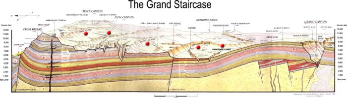
The western part of the Monument is dominated by the Paunsaugunt Plateau
and the Paria River
, and is adjacent to Bryce Canyon National Park
. This section shows the geologic progression of the Grand Staircase
.
 The center section is dominated by a single long ridge, called Kaiparowits Plateau
from the west, and called Fifty-Mile Mountain when viewed from the east. Fifty-Mile Mountain stretches southeast from the town of Escalante to the Colorado River
in Glen Canyon
. The eastern face of the mountain is a steep, 2200 foot (650 m) escarpment
. The western side (the Kaiparowits Plateau) is a shallow slope descending to the south and west.
East of Fifty Mile Mountain are the Canyons of the Escalante
. The Monument is bounded by Glen Canyon National Recreation Area
on the east and south. The most popular hiking and backpacking area is the Canyons of the Escalante
, shared with Glen Canyon National Recreation Area
. Highlights include the slot canyon
s of Peekaboo, Spooky and Brimstone Canyons
, and the backpacking areas of lower Coyote Gulch
and of Harris Wash
.
The Hole-in-the-Rock Road
extends southeast from the town of Escalante, along the base of Fifty Mile Mountain. It is important in the history of The Church of Jesus Christ of Latter-day Saints and the settlements of southeast Utah, including Bluff
, as well as providing access to the Canyons of the Escalante, and to the flat desert at the base of Fifty Mile Mountain that is actively used for grazing cattle.
rather than the National Park Service
. This was the first National Monument managed by the BLM. Visitor centers are located in Cannonville
, Big Water
, Escalante
, and Kanab
.
In 2002, a volunteer at Grand Staircase-Escalante discovered a 75 million-year-old dinosaur near the Arizona border. On October 3, 2007, the dinosaur's name, Gryposaurus monumentensis (hook-beaked lizard from the monument) was announced in the Zoological Journal of the Linnean Society
. G. monumentensis was at least 30 feet (9.1 m) long and 10 feet (3 m) tall, and has a powerful jaw with more than 800 teeth. Many of the specimens from the Kaiparowits Formation
are reposited at the Utah Museum of Natural History
.
Two ceratopsid (horned) dinosaurs, also discovered at Grand Staircase-Escalante, were introduced by the Utah Geological Survey
in 2007. They were uncovered in the Wahweap formation, which is just below the Kaiparowits formation where the duckbill was extracted. They lived about 80 million or 81 million years ago. The two fossils are called the Last Chance skull and the Nipple Butte skull. They were found in 2002 and 2001, respectively.
, somewhere around AD 500. Both the Fremont
and ancestral Puebloan people lived here; the Fremont hunting and gathering below the plateau and near the Escalante Valley, and the ancestral Puebloans farming in the canyons. Both groups grew corn, beans, and squash, and built brush-roofed pithouses and took advantage of natural rock shelters. Ruins and rock art
can be found throughout the Monument.
The first record of white settlers in the region dates from 1866, when Captain James Andrus led a group of cavalry to the headwaters of the Escalante River. In 1871 Jacob Hamblin of Kanab
, on his way to resupply the second John Wesley Powell
expedition, mistook the Escalante River for the Dirty Devil River
and became the first Anglo to travel the length of the canyon.
In 1879 the San Juan Expedition
crossed through the Monument on their way to a proposed Mormon colony in the far southeastern corner of Utah. Traveling on a largely unexplored route, the group eventually arrived at the 1200-foot (400 m) sandstone cliffs that surrounded Glen Canyon
. They found the only breach for many miles in the otherwise vertical cliffs, which they named Hole-in-the-Rock
. The narrow, steep, and rocky crevice eventually led to a steep sandy slope in the lower section and eventually down to the Colorado River
. With winter settling in, the company decided to go forward, down the crevice, rather than retreat. After six weeks of labor, including excavation and the use of explosives to shift rock, they rigged a pulley system to lower their wagons and animals down the resulting road and off the cliff. There they built a ferry, crossed the river and climbed back out through Cottonwood Canyon on the other side.
, and was controversial from the moment of creation. The declaration ceremony was held at Grand Canyon National Park
in Arizona
, and not in the state of Utah. The Utah congressional delegation and state governor were notified only 24 hours in advance. This was seen by many as a transparent political ploy to gain votes in the contested state of Arizona. That November, Clinton won Arizona by a margin of 2.2%, and lost Utah to Republican Bob Dole
by 21.1%.
Local officials and Congressman Bill Orton
(D - UT) objected to the designation of the Monument, questioning whether the Antiquities Act allowed such vast amounts of land to be designated. Monument designation also nixed the Andalex Coal Mine that was proposed for a remote location on the Kaiparowitz Plateau, and promised to generate jobs for the local economy.
Wilderness
designation for the lands in the Monument had long been sought by environmental groups; while designation of the Monument is not legally the same as Wilderness designation, for most practical purposes it is very similar. Bill Clinton significantly improved his standing with environmentalists by designating the Monument.
There are contentious issues peculiar to the state of Utah. Certain plots of land were assigned when Utah became a state (in 1896) as School and Institutional Trust Lands (SITLa, a Utah state agency), to be managed to produce funds for the state school system. These lands included scattered plots in the Monument that, critics claimed, could no longer be developed for the sake of Utah's school children. The SITLa plots within the Monument were exchanged for federal lands elsewhere in Utah, plus equivalent mineral rights and $13 million dollars cash by an act of Congress, the Utah Schools and Lands Exchange Act of 1998, supported by Democrats and Republicans, and signed into law as Public Law 105-335 on October 31, 1998.
A more difficult problem is the resolution of United States Revised statute 2477
(R.S. 2477) road claims. R.S. 2477 (Section 8 of the 1866 Mining Act) states: "The right-of-way for the construction of highways over public lands, not reserved for public uses, is hereby granted." The statute was repealed by the Federal Land Policy and Management Act
(FLPMA) of 1976, but the repeal was subject to valid existing rights. A process for resolving disputed claims has not been established, and in 1996, the 104th Congress passed a law which prohibited Clinton-administration RS2477 proposed resolution regulations from taking effect without Congressional approval. As of 2005, dirt roads in the Monument are highly disputed, with Kane County officials placing Kane County signs on roads they claim and occasionally applying bulldozers to grade claimed roads, while the BLM tries to exert control over the same roads. Resolution of this dispute is unlikely in the immediate future.
Acre
The acre is a unit of area in a number of different systems, including the imperial and U.S. customary systems. The most commonly used acres today are the international acre and, in the United States, the survey acre. The most common use of the acre is to measure tracts of land.The acre is related...
s (7,571 km2) of land in southern Utah
Utah
Utah is a state in the Western United States. It was the 45th state to join the Union, on January 4, 1896. Approximately 80% of Utah's 2,763,885 people live along the Wasatch Front, centering on Salt Lake City. This leaves vast expanses of the state nearly uninhabited, making the population the...
, the United States
United States
The United States of America is a federal constitutional republic comprising fifty states and a federal district...
. There are three main regions: the Grand Staircase
Grand Staircase
For the similarly named structure on the RMS Titanic, see Grand Staircase of the TitanicFor the stairs in the White House see Grand Staircase ...
, the Kaiparowits Plateau
Kaiparowits Plateau
right|Location of the Kaiparowits Plateau within UtahThe Kaiparowits Plateau is a large, elevated landform located in southern Utah, in the southwestern United States. Along with the Grand Staircase and the Canyons of the Escalante, it makes up a significant portion of the Grand...
, and the Canyons of the Escalante
Escalante River
right|Location of the Escalante River within UtahThe Escalante River is a tributary of the Colorado River. It is formed by the confluence of North and Birch Creeks near the town of Escalante in south-central Utah, and from there flows southeast for approximately before joining Lake Powell...
. President Bill Clinton
Bill Clinton
William Jefferson "Bill" Clinton is an American politician who served as the 42nd President of the United States from 1993 to 2001. Inaugurated at age 46, he was the third-youngest president. He took office at the end of the Cold War, and was the first president of the baby boomer generation...
designated the area as a U.S. National Monument
U.S. National Monument
A National Monument in the United States is a protected area that is similar to a National Park except that the President of the United States can quickly declare an area of the United States to be a National Monument without the approval of Congress. National monuments receive less funding and...
in 1996 using his authority under the Antiquities Act
Antiquities Act
The Antiquities Act of 1906, officially An Act for the Preservation of American Antiquities , is an act passed by the United States Congress and signed into law by Theodore Roosevelt on June 8, 1906, giving the President of the United States authority to, by executive order, restrict the use of...
. In terms of land area, it is the largest of all U.S. National Monuments.
Geography
The Monument stretches from the towns of Big Water, GlendaleGlendale, Utah
Glendale is a town in Kane County, Utah, United States. The population was 355 at the 2000 census. It was founded in 1862 by Mormon pioneers John and William Berry, abandoned in 1866 due to Indian attacks, and resettled in 1871.-Geography:...
and Kanab, Utah
Kanab, Utah
Kanab is a city in and the county seat of Kane County, Utah, United States. The area was first settled in 1864 and the town was founded in 1870 when ten Mormon families moved into the area. The population was 3,564 at the 2000 census...
on the southwest, to the towns of Escalante
Escalante, Utah
Escalante is a city in Garfield County, Utah, United States, along Utah Scenic Byway 12. As of the 2000 census, the city population was 818.The town was named after Silvestre Vélez de Escalante, a Franciscan missionary and the first European explorer in the region...
and Boulder
Boulder, Utah
Boulder is a town in Garfield County, Utah, United States, 27 miles northeast of Escalante on Utah Scenic Byway 12 at its intersection with the Burr Trail...
on the northeast. It is slightly larger in area than the state of Delaware
Delaware
Delaware is a U.S. state located on the Atlantic Coast in the Mid-Atlantic region of the United States. It is bordered to the south and west by Maryland, and to the north by Pennsylvania...
.
The western part of the Monument is dominated by the Paunsaugunt Plateau
Paunsaugunt Plateau
The Paunsaugunt Plateau is a dissected plateau, rising to an elevation of , in southwestern Utah in the United States. Located in northern Kane County and southwestern Garfield County, it is approximately wide, and extends southward from the Sevier Plateau approximately , terminating in the Pink...
and the Paria River
Paria River
The Paria River is a tributary of the Colorado River, approximately long, in southern Utah and northern Arizona in the United States. It drains a rugged and arid region northwest of the Colorado, flowing through roadless slot canyons along part of its course....
, and is adjacent to Bryce Canyon National Park
Bryce Canyon National Park
Bryce Canyon National Park is a national park located in southwestern Utah in the United States. The major feature of the park is Bryce Canyon which, despite its name, is not a canyon but a giant natural amphitheater created by erosion along the eastern side of the Paunsaugunt Plateau...
. This section shows the geologic progression of the Grand Staircase
Grand Staircase
For the similarly named structure on the RMS Titanic, see Grand Staircase of the TitanicFor the stairs in the White House see Grand Staircase ...
.
Kaiparowits Plateau
right|Location of the Kaiparowits Plateau within UtahThe Kaiparowits Plateau is a large, elevated landform located in southern Utah, in the southwestern United States. Along with the Grand Staircase and the Canyons of the Escalante, it makes up a significant portion of the Grand...
from the west, and called Fifty-Mile Mountain when viewed from the east. Fifty-Mile Mountain stretches southeast from the town of Escalante to the Colorado River
Colorado River
The Colorado River , is a river in the Southwestern United States and northwestern Mexico, approximately long, draining a part of the arid regions on the western slope of the Rocky Mountains. The watershed of the Colorado River covers in parts of seven U.S. states and two Mexican states...
in Glen Canyon
Glen Canyon
Glen Canyon is a canyon that is located in southeastern and south central Utah and northwestern Arizona within the Vermilion Cliffs area. It was carved by the Colorado River....
. The eastern face of the mountain is a steep, 2200 foot (650 m) escarpment
Escarpment
An escarpment is a steep slope or long cliff that occurs from erosion or faulting and separates two relatively level areas of differing elevations.-Description and variants:...
. The western side (the Kaiparowits Plateau) is a shallow slope descending to the south and west.
East of Fifty Mile Mountain are the Canyons of the Escalante
Canyons of the Escalante
The Canyons of the Escalante is a collective name for the erosional landforms created by the Escalante River and its tributaries, the Escalante River Basin. Located in southern Utah in the western United States, these sandstone features include high vertical canyon walls, water pockets, narrow...
. The Monument is bounded by Glen Canyon National Recreation Area
Glen Canyon National Recreation Area
Glen Canyon National Recreation Area is a recreation and conservation unit of the National Park Service that encompasses the area around Lake Powell and lower Cataract Canyon in Utah and Arizona, covering 1,254,429 acres of mostly desert...
on the east and south. The most popular hiking and backpacking area is the Canyons of the Escalante
Canyons of the Escalante
The Canyons of the Escalante is a collective name for the erosional landforms created by the Escalante River and its tributaries, the Escalante River Basin. Located in southern Utah in the western United States, these sandstone features include high vertical canyon walls, water pockets, narrow...
, shared with Glen Canyon National Recreation Area
Glen Canyon National Recreation Area
Glen Canyon National Recreation Area is a recreation and conservation unit of the National Park Service that encompasses the area around Lake Powell and lower Cataract Canyon in Utah and Arizona, covering 1,254,429 acres of mostly desert...
. Highlights include the slot canyon
Slot canyon
A slot canyon is a narrow canyon, formed by the wear of water rushing through rock. A slot canyon is significantly deeper than it is wide. Some slot canyons can measure less than one metre across at the top but drop more than 30 m to the floor of the canyon.Most slot canyons are formed in...
s of Peekaboo, Spooky and Brimstone Canyons
Coyote Gulch
Coyote Gulch is a tributary of the Escalante River, located in Garfield and Kane Counties in southern Utah, in the western United States. Over 25 miles long, it exhibits many of the geologic features found in the Canyons of the Escalante, including high vertical canyon walls, narrow slot canyons,...
, and the backpacking areas of lower Coyote Gulch
Coyote Gulch
Coyote Gulch is a tributary of the Escalante River, located in Garfield and Kane Counties in southern Utah, in the western United States. Over 25 miles long, it exhibits many of the geologic features found in the Canyons of the Escalante, including high vertical canyon walls, narrow slot canyons,...
and of Harris Wash
Harris Wash
right|Location of Harris Wash within UtahHarris Wash is a long tributary of the Escalante River located in Garfield County in southern Utah, in the western United States. Over 40 miles long, it exhibits many of the geologic features found in the Canyons of the Escalante, including high vertical...
.
The Hole-in-the-Rock Road
Hole in the Rock Road
The Hole in the Rock Trail is a historic road running west of the Escalante River in southern Utah in the western United States. Running almost from near Escalante to Bluff, it travels within the borders of the Grand Staircase-Escalante National Monument and the adjacent Glen Canyon National...
extends southeast from the town of Escalante, along the base of Fifty Mile Mountain. It is important in the history of The Church of Jesus Christ of Latter-day Saints and the settlements of southeast Utah, including Bluff
Bluff, Utah
Bluff is a census-designated place in San Juan County, Utah, United States. The population was 320 at the 2000 census.-Geography:Bluff is located at , in the scenic and very sparsely populated southeastern Utah canyonlands of the Colorado Plateau.According to the United States Census Bureau, the...
, as well as providing access to the Canyons of the Escalante, and to the flat desert at the base of Fifty Mile Mountain that is actively used for grazing cattle.
Management
The Monument is managed by the Bureau of Land ManagementBureau of Land Management
The Bureau of Land Management is an agency within the United States Department of the Interior which administers America's public lands, totaling approximately , or one-eighth of the landmass of the country. The BLM also manages of subsurface mineral estate underlying federal, state and private...
rather than the National Park Service
National Park Service
The National Park Service is the U.S. federal agency that manages all national parks, many national monuments, and other conservation and historical properties with various title designations...
. This was the first National Monument managed by the BLM. Visitor centers are located in Cannonville
Cannonville, Utah
Cannonville is a town in Garfield County, Utah, United States, along Utah Scenic Byway 12. In the 2000 census, the population was 148, a small increase over the 1990 figure of 131.-Geography:Cannonville is located at ....
, Big Water
Big Water, Utah
Big Water is a town in Kane County, Utah, United States. The population was 417 at the 2000 census, a modest increase over the 1990 figure of 326. It is located 17 miles north of Page, Arizona on US-89 near Lake Powell and the Glen Canyon Dam. It was originally called Glen Canyon City and housed...
, Escalante
Escalante, Utah
Escalante is a city in Garfield County, Utah, United States, along Utah Scenic Byway 12. As of the 2000 census, the city population was 818.The town was named after Silvestre Vélez de Escalante, a Franciscan missionary and the first European explorer in the region...
, and Kanab
Kanab, Utah
Kanab is a city in and the county seat of Kane County, Utah, United States. The area was first settled in 1864 and the town was founded in 1870 when ten Mormon families moved into the area. The population was 3,564 at the 2000 census...
.
Paleontology
Since 2000, numerous dinosaur fossils over 75 million years old have been found at Grand Staircase-Escalante.In 2002, a volunteer at Grand Staircase-Escalante discovered a 75 million-year-old dinosaur near the Arizona border. On October 3, 2007, the dinosaur's name, Gryposaurus monumentensis (hook-beaked lizard from the monument) was announced in the Zoological Journal of the Linnean Society
Zoological Journal of the Linnean Society
Zoological Journal of the Linnean Society is the scientific journal of the Linnean Society published by Wiley-Blackwell.According to EBSCOhost, it "[p]resents original papers on zoology with an emphasis on the diversity, systematics, interrelationships, and habits of animals both living and...
. G. monumentensis was at least 30 feet (9.1 m) long and 10 feet (3 m) tall, and has a powerful jaw with more than 800 teeth. Many of the specimens from the Kaiparowits Formation
Kaiparowits Formation
The Kaiparowits Formation is a sedimentary rock formation found in the Kaiparowits Plateau in Grand Staircase-Escalante National Monument, in the southern part of Utah in the western United States. It is over 2800 feet thick, and is Campanian in age...
are reposited at the Utah Museum of Natural History
Utah Museum of Natural History
The Natural History Museum of Utah is a museum located at the Rio Tinto Center on the campus of the University of Utah in Salt Lake City, Utah, United States. The museum shows exhibits of natural history subjects, specifically about Utah's natural history...
.
Two ceratopsid (horned) dinosaurs, also discovered at Grand Staircase-Escalante, were introduced by the Utah Geological Survey
Utah Geological Survey
The Utah Geological Survey is based in Salt Lake City, Utah, USA. It also has an office in Cedar City, Utah.It is a division of the Utah Department of Natural Resources and is an applied scientific agency, which creates, interprets, and provides information about Utah's geological environment,...
in 2007. They were uncovered in the Wahweap formation, which is just below the Kaiparowits formation where the duckbill was extracted. They lived about 80 million or 81 million years ago. The two fossils are called the Last Chance skull and the Nipple Butte skull. They were found in 2002 and 2001, respectively.
Human history
Humans didn't settle permanently in the area until the Basketmaker III EraBasketmaker III Era
The Basketmaker III Era, AD 500 to 750, also called the "Modified Basketmaker" period, was the third period in which Ancient Pueblo People were cultivating food, began making pottery and living in more sophisticated clusters of pit-house dwellings...
, somewhere around AD 500. Both the Fremont
Fremont
- Places :- Other uses :*The Fremont Bridge , in Portland, Oregon*The Fremont Bridge , in Seattle, Washington*Fremont River , a tributary of the Colorado River*Mount Fremont, Washington, in maximum elevation...
and ancestral Puebloan people lived here; the Fremont hunting and gathering below the plateau and near the Escalante Valley, and the ancestral Puebloans farming in the canyons. Both groups grew corn, beans, and squash, and built brush-roofed pithouses and took advantage of natural rock shelters. Ruins and rock art
Rock art
Rock art is a term used in archaeology for any human-made markings made on natural stone. They can be divided into:*Petroglyphs - carvings into stone surfaces*Pictographs - rock and cave paintings...
can be found throughout the Monument.
The first record of white settlers in the region dates from 1866, when Captain James Andrus led a group of cavalry to the headwaters of the Escalante River. In 1871 Jacob Hamblin of Kanab
Kanab, Utah
Kanab is a city in and the county seat of Kane County, Utah, United States. The area was first settled in 1864 and the town was founded in 1870 when ten Mormon families moved into the area. The population was 3,564 at the 2000 census...
, on his way to resupply the second John Wesley Powell
John Wesley Powell
John Wesley Powell was a U.S. soldier, geologist, explorer of the American West, and director of major scientific and cultural institutions...
expedition, mistook the Escalante River for the Dirty Devil River
Dirty Devil River
The Dirty Devil River is a long tributary of the Colorado River, located in the U.S. state of Utah. It flows through southern Utah from the confluence of Fremont River and Muddy Creek to the Colorado River.-Course:...
and became the first Anglo to travel the length of the canyon.
In 1879 the San Juan Expedition
San Juan Expedition
right|Route of the San Juan Expedition through UtahThe San Juan Expedition was a group of Mormon settlers intent on establishing a colony in what is now southeastern Utah, in the western United States...
crossed through the Monument on their way to a proposed Mormon colony in the far southeastern corner of Utah. Traveling on a largely unexplored route, the group eventually arrived at the 1200-foot (400 m) sandstone cliffs that surrounded Glen Canyon
Glen Canyon
Glen Canyon is a canyon that is located in southeastern and south central Utah and northwestern Arizona within the Vermilion Cliffs area. It was carved by the Colorado River....
. They found the only breach for many miles in the otherwise vertical cliffs, which they named Hole-in-the-Rock
Hole in the Rock (road)
Hole in the Rock is a narrow and steep crevice in the western rim of Glen Canyon, in southern Utah in the western United States. Together with another canyon on the eastern side of the Colorado River, it provided a route through what would otherwise be a large area of impassible terrain.In the...
. The narrow, steep, and rocky crevice eventually led to a steep sandy slope in the lower section and eventually down to the Colorado River
Colorado River
The Colorado River , is a river in the Southwestern United States and northwestern Mexico, approximately long, draining a part of the arid regions on the western slope of the Rocky Mountains. The watershed of the Colorado River covers in parts of seven U.S. states and two Mexican states...
. With winter settling in, the company decided to go forward, down the crevice, rather than retreat. After six weeks of labor, including excavation and the use of explosives to shift rock, they rigged a pulley system to lower their wagons and animals down the resulting road and off the cliff. There they built a ferry, crossed the river and climbed back out through Cottonwood Canyon on the other side.
Controversy
The Monument was declared in September 1996 at the height of the 1996 presidential election campaign by President Bill ClintonBill Clinton
William Jefferson "Bill" Clinton is an American politician who served as the 42nd President of the United States from 1993 to 2001. Inaugurated at age 46, he was the third-youngest president. He took office at the end of the Cold War, and was the first president of the baby boomer generation...
, and was controversial from the moment of creation. The declaration ceremony was held at Grand Canyon National Park
Grand Canyon National Park
Grand Canyon National Park is the United States' 15th oldest national park and is located in Arizona. Within the park lies the Grand Canyon, a gorge of the Colorado River, considered to be one of the Wonders of the World. The park covers of unincorporated area in Coconino and Mohave counties.Most...
in Arizona
Arizona
Arizona ; is a state located in the southwestern region of the United States. It is also part of the western United States and the mountain west. The capital and largest city is Phoenix...
, and not in the state of Utah. The Utah congressional delegation and state governor were notified only 24 hours in advance. This was seen by many as a transparent political ploy to gain votes in the contested state of Arizona. That November, Clinton won Arizona by a margin of 2.2%, and lost Utah to Republican Bob Dole
Bob Dole
Robert Joseph "Bob" Dole is an American attorney and politician. Dole represented Kansas in the United States Senate from 1969 to 1996, was Gerald Ford's Vice Presidential running mate in the 1976 presidential election, and was Senate Majority Leader from 1985 to 1987 and in 1995 and 1996...
by 21.1%.
Local officials and Congressman Bill Orton
Bill Orton
William "Bill" Orton was an American Democratic Congressman. He was a member of the United States House of Representatives from Utah from 1991 to 1997.-Early life and education:...
(D - UT) objected to the designation of the Monument, questioning whether the Antiquities Act allowed such vast amounts of land to be designated. Monument designation also nixed the Andalex Coal Mine that was proposed for a remote location on the Kaiparowitz Plateau, and promised to generate jobs for the local economy.
Wilderness
Wilderness
Wilderness or wildland is a natural environment on Earth that has not been significantly modified by human activity. It may also be defined as: "The most intact, undisturbed wild natural areas left on our planet—those last truly wild places that humans do not control and have not developed with...
designation for the lands in the Monument had long been sought by environmental groups; while designation of the Monument is not legally the same as Wilderness designation, for most practical purposes it is very similar. Bill Clinton significantly improved his standing with environmentalists by designating the Monument.
There are contentious issues peculiar to the state of Utah. Certain plots of land were assigned when Utah became a state (in 1896) as School and Institutional Trust Lands (SITLa, a Utah state agency), to be managed to produce funds for the state school system. These lands included scattered plots in the Monument that, critics claimed, could no longer be developed for the sake of Utah's school children. The SITLa plots within the Monument were exchanged for federal lands elsewhere in Utah, plus equivalent mineral rights and $13 million dollars cash by an act of Congress, the Utah Schools and Lands Exchange Act of 1998, supported by Democrats and Republicans, and signed into law as Public Law 105-335 on October 31, 1998.
A more difficult problem is the resolution of United States Revised statute 2477
Revised statute 2477
Revised Statute 2477 was enacted by the United States Congress in 1866 to encourage the settlement of the Western United States by the development of a system of highways...
(R.S. 2477) road claims. R.S. 2477 (Section 8 of the 1866 Mining Act) states: "The right-of-way for the construction of highways over public lands, not reserved for public uses, is hereby granted." The statute was repealed by the Federal Land Policy and Management Act
Federal Land Policy and Management Act
Federal Land Policy Management Act, or FLPMA , is a United States federal law that governs the way in which the public lands administered by the Bureau of Land Management are managed. The law was enacted in 1976 by the 94th Congress. Congress recognized the value of the public lands, declaring...
(FLPMA) of 1976, but the repeal was subject to valid existing rights. A process for resolving disputed claims has not been established, and in 1996, the 104th Congress passed a law which prohibited Clinton-administration RS2477 proposed resolution regulations from taking effect without Congressional approval. As of 2005, dirt roads in the Monument are highly disputed, with Kane County officials placing Kane County signs on roads they claim and occasionally applying bulldozers to grade claimed roads, while the BLM tries to exert control over the same roads. Resolution of this dispute is unlikely in the immediate future.
See also
- Ancient Pueblo PeoplesAncient Pueblo PeoplesAncient Pueblo People or Ancestral Pueblo peoples were an ancient Native American culture centered on the present-day Four Corners area of the United States, comprising southern Utah, northern Arizona, northwest New Mexico, and southern Colorado...
- Burr Trail Scenic BackwayBurr Trail Scenic BackwayThe Burr Trail Scenic Backway is a backcountry route extending from the town of Boulder, Utah, through Grand Staircase-Escalante National Monument into Capital Reef National Park and then to the community of Bullfrog in Glen Canyon National Recreation Area....
- Grand StaircaseGrand StaircaseFor the similarly named structure on the RMS Titanic, see Grand Staircase of the TitanicFor the stairs in the White House see Grand Staircase ...
- Grosvenor ArchGrosvenor ArchGrosvenor Arch is a unique sandstone double arch located within Grand Staircase-Escalante National Monument in southern Utah. It is named to honor Gilbert Hovey Grosvenor , a president of the National Geographic Society, publishers of the National Geographic Magazine.Located in northern Kane...
- Kodachrome Basin State ParkKodachrome Basin State ParkKodachrome Basin is a state park of Utah, USA. It is situated above sea level, south of Utah Route 12, and southeast of Bryce Canyon National Park. It is accessible from the north from Cannonville by a paved road and from the south by Road 400, a dirt road from the Page, Arizona area to...
- Road 400 - traverses a portion of the monument
- Silvestre Vélez de Escalante
External links
- Bureau of Land Management: Grand Staircase-Escalante NM
- Grand Staircase Escalante Partners support for public awareness, interpretive, educational, scientific, scenic, historical, and cultural activities.