

Glen Canyon National Recreation Area
Encyclopedia
National Park Service
The National Park Service is the U.S. federal agency that manages all national parks, many national monuments, and other conservation and historical properties with various title designations...
(USA) that encompasses the area around Lake Powell
Lake Powell
Lake Powell is a huge reservoir on the Colorado River, straddling the border between Utah and Arizona . It is the second largest man-made reservoir in the United States behind Lake Mead, storing of water when full...
and lower Cataract Canyon
Cataract Canyon
Cataract Canyon is a long canyon of the Colorado River located within Canyonlands National Park and Glen Canyon National Recreation Area in Utah. It begins on the upstream end at the confluence with the Green River and ends at the confluence of the Dirty Devil River...
in Utah
Utah
Utah is a state in the Western United States. It was the 45th state to join the Union, on January 4, 1896. Approximately 80% of Utah's 2,763,885 people live along the Wasatch Front, centering on Salt Lake City. This leaves vast expanses of the state nearly uninhabited, making the population the...
and Arizona
Arizona
Arizona ; is a state located in the southwestern region of the United States. It is also part of the western United States and the mountain west. The capital and largest city is Phoenix...
, covering 1,254,429 acres (5,076 km2) of mostly desert. The recreation area borders Capitol Reef National Park
Capitol Reef National Park
Capitol Reef National Park is a United States National Park, in south-central Utah. It is 100 miles long but fairly narrow. The park, established in 1971, preserves 378 mi² and is open all year, although May through September are the most popular months.Called "Wayne Wonderland" in the 1920s...
and Canyonlands National Park
Canyonlands National Park
Canyonlands National Park is a U.S. National Park located in southeastern Utah near the town of Moab and preserves a colorful landscape eroded into countless canyons, mesas and buttes by the Colorado River, the Green River, and their respective tributaries. The park is divided into four districts:...
on the north, Grand Staircase-Escalante National Monument
Grand Staircase-Escalante National Monument
The Grand Staircase-Escalante National Monument contains 1.9 million acres of land in southern Utah, the United States. There are three main regions: the Grand Staircase, the Kaiparowits Plateau, and the Canyons of the Escalante. President Bill Clinton designated the area as a U.S. National...
on the west, Vermilion Cliffs National Monument
Vermilion Cliffs National Monument
Vermilion Cliffs National Monument is located in Arizona, immediately south of the Utah state line. This National Monument, 294,000 acre in area, protects the Paria Plateau, Vermilion Cliffs, Coyote Buttes, and Paria Canyon...
and the northeasternmost reaches of Grand Canyon National Park
Grand Canyon National Park
Grand Canyon National Park is the United States' 15th oldest national park and is located in Arizona. Within the park lies the Grand Canyon, a gorge of the Colorado River, considered to be one of the Wonders of the World. The park covers of unincorporated area in Coconino and Mohave counties.Most...
on the southwest, and the Navajo Indian Reservation on the southeast.
The Glen Canyon NRA was established in 1972 "to provide for public use and enjoyment and to preserve the area's scientific, historic, and scenic features."
The stated purpose of Glen Canyon NRA is for recreation as well as preservation (whereas a national park
National park
A national park is a reserve of natural, semi-natural, or developed land that a sovereign state declares or owns. Although individual nations designate their own national parks differently A national park is a reserve of natural, semi-natural, or developed land that a sovereign state declares or...
may carry more emphasis on natural preservation). As such, the area has been developed for access to Lake Powell via 5 marinas, 4 camping grounds, two small airports, and houseboat
Houseboat
A houseboat is a boat that has been designed or modified to be used primarily as a human dwelling. Some houseboats are not motorized, because they are usually moored, kept stationary at a fixed point and often tethered to land to provide utilities...
rental concessions.
The southwestern end of Glen Canyon NRA in Arizona can be accessed via U.S. Route 89 and State Route 98
Arizona State Route 98
State Route 98 is a state highway in Coconino County in the U.S. state of Arizona.-Route description:It runs from its junction with US 89 just south of Page to its junction with US 160 to the southeast...
. State Route 95 and State Route 276 lead to the northeastern end of the recreation area in Utah.
The current Lake Powell lies above Glen Canyon
Glen Canyon
Glen Canyon is a canyon that is located in southeastern and south central Utah and northwestern Arizona within the Vermilion Cliffs area. It was carved by the Colorado River....
, which was flooded by the Glen Canyon Dam
Glen Canyon Dam
Glen Canyon Dam is a concrete arch dam on the Colorado River in northern Arizona in the United States, just north of Page. The dam was built to provide hydroelectricity and flow regulation from the upper Colorado River Basin to the lower. Its reservoir is called Lake Powell, and is the second...
, completed in 1966.
Recreation
Lake PowellLake Powell
Lake Powell is a huge reservoir on the Colorado River, straddling the border between Utah and Arizona . It is the second largest man-made reservoir in the United States behind Lake Mead, storing of water when full...
has nearly 2000 miles (3,218.7 km) of fish-holding shoreline and provides opportunity to fish for largemouth bass, smallmouth bass and striped bass that swim in the midst of the recreation area.
Lake Powell National Golf Course Championship is an 18-hole course sitting on a high mesa
Mesa
A mesa or table mountain is an elevated area of land with a flat top and sides that are usually steep cliffs. It takes its name from its characteristic table-top shape....
overlooking the Glen Canyon Dam
Glen Canyon Dam
Glen Canyon Dam is a concrete arch dam on the Colorado River in northern Arizona in the United States, just north of Page. The dam was built to provide hydroelectricity and flow regulation from the upper Colorado River Basin to the lower. Its reservoir is called Lake Powell, and is the second...
, Lake Powell, and Vermillion Cliffs.
Several local marinas provide houseboats, powerboats, jet skis, kayaks, fishing gear, and related equipment to visitors.
Geology
The Geology of the area is dominated by the Glen Canyon GroupGlen Canyon Group
The Glen Canyon Group is a geologic group of formations that is spread across the U.S. states of Nevada, Utah, northern Arizona, north west New Mexico and western Colorado. It is sometimes called the Glen Canyon Sandstone in Colorado and Utah. There are four formations within the group...
, consisting of the Navajo Sandstone
Navajo Sandstone
Navajo Sandstone is a geologic formation in the Glen Canyon Group that is spread across the U.S. states of northern Arizona, northwest Colorado, and Utah; as part of the Colorado Plateau province of the United States...
, Kayenta Formation
Kayenta Formation
The Kayenta Formation is a geologic layer in the Glen Canyon Group that is spread across the Colorado Plateau province of the United States, including northern Arizona, northwest Colorado, Nevada, and Utah. This rock formation is particularly prominent in southeastern Utah, where it is seen in the...
, and Wingate Sandstone
Wingate Sandstone
Wingate Sandstone is a geologic formation in the Glen Canyon Group that is spread across the Colorado Plateau province of the United States, including northern Arizona, northwest Colorado, Nevada, and Utah. This rock formation is particularly prominent in southeastern Utah, where it forms...
. The entire stratigraphic section included rocks dating from the Cretaceous
Cretaceous
The Cretaceous , derived from the Latin "creta" , usually abbreviated K for its German translation Kreide , is a geologic period and system from circa to million years ago. In the geologic timescale, the Cretaceous follows the Jurassic period and is followed by the Paleogene period of the...
to Pennsylvanian
Pennsylvanian
The Pennsylvanian is, in the ICS geologic timescale, the younger of two subperiods of the Carboniferous Period. It lasted from roughly . As with most other geochronologic units, the rock beds that define the Pennsylvanian are well identified, but the exact date of the start and end are uncertain...
.
Graffiti Removal and Intervention Team (GRIT)
With over one million visitors per year, it is inevitable that some will deface the rock faces of the canyon. The Glen Canyon NRA has implemented a voluntourism program wherein volunteers sign up for a five-day houseboat trip to remove graffiti from the canyon walls.See also
- Glen CanyonGlen CanyonGlen Canyon is a canyon that is located in southeastern and south central Utah and northwestern Arizona within the Vermilion Cliffs area. It was carved by the Colorado River....
- Glen Canyon DamGlen Canyon DamGlen Canyon Dam is a concrete arch dam on the Colorado River in northern Arizona in the United States, just north of Page. The dam was built to provide hydroelectricity and flow regulation from the upper Colorado River Basin to the lower. Its reservoir is called Lake Powell, and is the second...
- Glen Canyon InstituteGlen canyon instituteGlen Canyon Institute is a non-profit organization founded in 1996 dedicated to the restoration of the Colorado River through Glen Canyon, which is currently covered by Lake Powell, a reservoir created by Glen Canyon Dam...
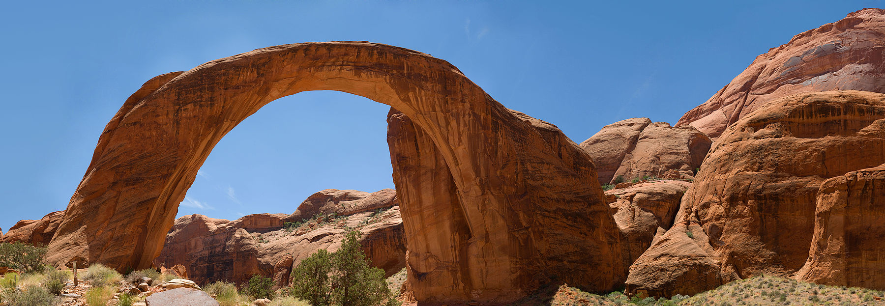
- Rainbow Bridge National MonumentRainbow Bridge National MonumentRainbow Bridge National Monument is administered by Glen Canyon National Recreation Area, southern Utah, USA. Rainbow Bridge is often described as the world's highest natural bridge. The span of Rainbow Bridge was reported in 1974 by the Bureau of Reclamation to be , but a laser measurement in...
External links
- Official National Park Service site
- Official National Park Service Concessionaire Site Lake Powell Resorts & Marinas, managed by ARAMARK, is an authorized concessioner of the National Park Service, Glen Canyon National Recreation Area.
- Glen Canyon Natural History Association
- Page Lake Powell Chamber of Commerce
- Lake Powell National Golf Course scenic 18-hole golf course
- Lake Powell Yacht Club to serve the interest of boat owners and water recreational enthusiasts