

Canyons of the Escalante
Encyclopedia
Escalante River
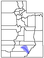
right|Location of the Escalante River within UtahThe Escalante River is a tributary of the Colorado River. It is formed by the confluence of North and Birch Creeks near the town of Escalante in south-central Utah, and from there flows southeast for approximately before joining Lake Powell...
and its tributaries, the Escalante River Basin. Located in southern Utah
Utah
Utah is a state in the Western United States. It was the 45th state to join the Union, on January 4, 1896. Approximately 80% of Utah's 2,763,885 people live along the Wasatch Front, centering on Salt Lake City. This leaves vast expanses of the state nearly uninhabited, making the population the...
in the western United States
United States
The United States of America is a federal constitutional republic comprising fifty states and a federal district...
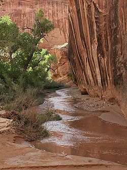
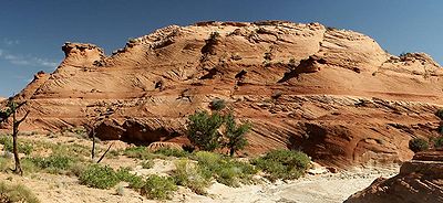
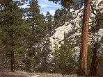
, these sandstone features include high vertical canyon walls, water pockets, narrow slot canyons, domes, pedestals, arches, and natural bridges. This area, extending over 1500 square miles (3900 km²) and rising in elevation from 3600 feet (1100 m) to over 11,000 feet (3350 m), is one of the three main sections of the Grand Staircase-Escalante National Monument
Grand Staircase-Escalante National Monument
The Grand Staircase-Escalante National Monument contains 1.9 million acres of land in southern Utah, the United States. There are three main regions: the Grand Staircase, the Kaiparowits Plateau, and the Canyons of the Escalante. President Bill Clinton designated the area as a U.S. National...
, is part of the Glen Canyon National Recreation Area
Glen Canyon National Recreation Area
Glen Canyon National Recreation Area is a recreation and conservation unit of the National Park Service that encompasses the area around Lake Powell and lower Cataract Canyon in Utah and Arizona, covering 1,254,429 acres of mostly desert...
, and borders the adjacent Capitol Reef National Park
Capitol Reef National Park
Capitol Reef National Park is a United States National Park, in south-central Utah. It is 100 miles long but fairly narrow. The park, established in 1971, preserves 378 mi² and is open all year, although May through September are the most popular months.Called "Wayne Wonderland" in the 1920s...
. It is an increasingly popular recreational destination in Utah's Canyon Country.
Geography
Aquarius Plateau
The Aquarius Plateau is a physiographic region within Garfield and Wayne counties in south-central Utah. The plateau, an uplift on the much larger Colorado Plateau, is the highest in North America...
, in Utah's Garfield County
Garfield County, Utah
Garfield County is a county located in the U.S. state of Utah. As of 2000 the population was 4,735. It was named for James A. Garfield, President of the United States in 1881. Its county seat and largest city is Panguitch.-Geography:...
, just west of the town of Escalante
Escalante, Utah
Escalante is a city in Garfield County, Utah, United States, along Utah Scenic Byway 12. As of the 2000 census, the city population was 818.The town was named after Silvestre Vélez de Escalante, a Franciscan missionary and the first European explorer in the region...
. North and Birch Creeks merge to form the official start of the river and, just below the town, is joined by the flow of Pine Creek. From there the river runs southeast for over 65 miles (130 km) before meeting the Colorado River
Colorado River
The Colorado River , is a river in the Southwestern United States and northwestern Mexico, approximately long, draining a part of the arid regions on the western slope of the Rocky Mountains. The watershed of the Colorado River covers in parts of seven U.S. states and two Mexican states...
, in Kane County
Kane County, Utah
As of the census of 2000, there were 6,046 people, 2,237 households, and 1,628 families residing in the county. The population density was 2 people per square mile . There were 3,767 housing units at an average density of 1 per square mile...
. The lower section of the river, southeast of Coyote Gulch
Coyote Gulch
Coyote Gulch is a tributary of the Escalante River, located in Garfield and Kane Counties in southern Utah, in the western United States. Over 25 miles long, it exhibits many of the geologic features found in the Canyons of the Escalante, including high vertical canyon walls, narrow slot canyons,...
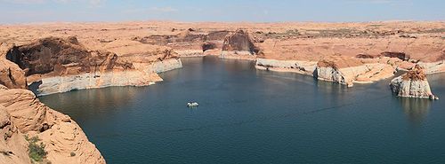
, is now beneath the surface of Lake Powell
Lake Powell
Lake Powell is a huge reservoir on the Colorado River, straddling the border between Utah and Arizona . It is the second largest man-made reservoir in the United States behind Lake Mead, storing of water when full...
.
Numerous side canyons also feed the main river, accounting for the large size of the basin. From the west, the major tributaries are Harris Wash
Harris Wash
right|Location of Harris Wash within UtahHarris Wash is a long tributary of the Escalante River located in Garfield County in southern Utah, in the western United States. Over 40 miles long, it exhibits many of the geologic features found in the Canyons of the Escalante, including high vertical...
, Twentyfive Mile Creek, Coyote Gulch, Fortymile Gulch
Fortymile Gulch
right|Location of Fortymile and Willow Gulches within UtahFortymile Gulch and Willow Gulch are tributaries of the Escalante River, located in Kane County in southern Utah, in the western United States...
, and Fiftymile Creek, along with the smaller Phipps, Fence, Scorpion, Davis, Clear, and Indian Creeks. Most of these larger creeks flow from the top of the Kaiparowits Plateau
Kaiparowits Plateau
right|Location of the Kaiparowits Plateau within UtahThe Kaiparowits Plateau is a large, elevated landform located in southern Utah, in the southwestern United States. Along with the Grand Staircase and the Canyons of the Escalante, it makes up a significant portion of the Grand...
or from the base of its eastern edge, the Straight Cliffs. An even greater number of tributaries flow in from the north and east, including Death Hollow and Calf Creeks, the combined Boulder and Deer Creeks, The Gulch, Wolverine and Silver Falls Creeks, and Choprock, Moody, Stevens, and Cow Canyons. Streams from the north flow from Boulder Mountain
Boulder Mountain (Utah)
Boulder Mountain in Utah, USA makes up half of the Aquarius Plateau of South Central Utah in Wayne and Garfield counties. The mountain rises to the west of Capitol Reef National Park and consists of steep slopes and cliffs with over 50,000 acres of rolling forest and meadowlands on the top...
, while those from the northeast originate in the Circle Cliffs area, near the Waterpocket Fold
Waterpocket Fold
The Waterpocket Fold is a geologic landform that defines Capitol Reef National Park in the western United States. This monoclinal fold extends for slightly over 100 miles in the desert of central Utah. It can be seen via three scenic routes in the park. One route leads to a famous landmark known as...
in Capitol Reef National Park
Capitol Reef National Park
Capitol Reef National Park is a United States National Park, in south-central Utah. It is 100 miles long but fairly narrow. The park, established in 1971, preserves 378 mi² and is open all year, although May through September are the most popular months.Called "Wayne Wonderland" in the 1920s...
.
Geology
The sandstone layers now exposed in the Canyons of the Escalante were deposited during the MesozoicMesozoic
The Mesozoic era is an interval of geological time from about 250 million years ago to about 65 million years ago. It is often referred to as the age of reptiles because reptiles, namely dinosaurs, were the dominant terrestrial and marine vertebrates of the time...
era, 180 to 225 million years ago , when this area was part of a large area of sand dunes. Near the end of the Cretaceous
Cretaceous
The Cretaceous , derived from the Latin "creta" , usually abbreviated K for its German translation Kreide , is a geologic period and system from circa to million years ago. In the geologic timescale, the Cretaceous follows the Jurassic period and is followed by the Paleogene period of the...
period, about 80 million years ago, the entire western section of North America entered an era of uplift and mountain-building, an event known as the Laramide orogeny
Laramide orogeny
The Laramide orogeny was a period of mountain building in western North America, which started in the Late Cretaceous, 70 to 80 million years ago, and ended 35 to 55 million years ago. The exact duration and ages of beginning and end of the orogeny are in dispute, as is the cause. The Laramide...
. More recently, additional uplift formed the Colorado Plateau
Colorado Plateau
The Colorado Plateau, also called the Colorado Plateau Province, is a physiographic region of the Intermontane Plateaus, roughly centered on the Four Corners region of the southwestern United States. The province covers an area of 337,000 km2 within western Colorado, northwestern New Mexico,...
province. These episodes of uplift raised the Aquarius Plateau
Aquarius Plateau
The Aquarius Plateau is a physiographic region within Garfield and Wayne counties in south-central Utah. The plateau, an uplift on the much larger Colorado Plateau, is the highest in North America...
to the extent that there were strong erosional forces acting on the Escalante River Basin. Wetter climates during the recent ice age
Ice age
An ice age or, more precisely, glacial age, is a generic geological period of long-term reduction in the temperature of the Earth's surface and atmosphere, resulting in the presence or expansion of continental ice sheets, polar ice sheets and alpine glaciers...
s of the Pleistocene
Pleistocene
The Pleistocene is the epoch from 2,588,000 to 11,700 years BP that spans the world's recent period of repeated glaciations. The name pleistocene is derived from the Greek and ....
period contributed to deep cutting of the canyon walls.
Additional details on the geology of the area can be found in the articles Geology of the Capitol Reef area
Geology of the Capitol Reef area
The exposed geology of the Capitol Reef area presents a record of mostly Mesozoic-aged sedimentation in an area of North America in and around Capitol Reef National Park. Nearly 10,000 feet of sedimentary strata are found in the Capitol Reef area, representing nearly 200 million years of...
and Geology of the Bryce Canyon area
Geology of the Bryce Canyon area
The exposed geology of the Bryce Canyon area in Utah shows a record of deposition that covers the last part of the Cretaceous Period and the first half of the Cenozoic era in that part of North America...
. Sandstone exposed in canyons nearer to the Colorado River are typically from the Glen Canyon Group
Glen Canyon Group
The Glen Canyon Group is a geologic group of formations that is spread across the U.S. states of Nevada, Utah, northern Arizona, north west New Mexico and western Colorado. It is sometimes called the Glen Canyon Sandstone in Colorado and Utah. There are four formations within the group...
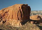
. The dark red cliffs of Coyote Gulch, for example, are composed of Navajo Sandstone
Navajo Sandstone
Navajo Sandstone is a geologic formation in the Glen Canyon Group that is spread across the U.S. states of northern Arizona, northwest Colorado, and Utah; as part of the Colorado Plateau province of the United States...
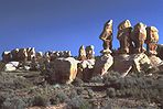
. The lighter sandstone domes of Dance Hall Rock and Sooner Rocks are formed from the higher Entrada sandstone
Entrada Sandstone
The Entrada Sandstone is a formation in the San Rafael Group that is spread across the U.S. states of Wyoming, Colorado, northwest New Mexico, northeast Arizona and southeast Utah...
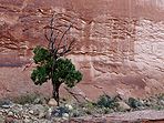
layer. Due to tilting of layers throughout the area, sandstone exposed at higher elevations near the town of Escalante (e.g. Deer Creek) may actually be from a lower layer, Wingate Sandstone
Wingate Sandstone
Wingate Sandstone is a geologic formation in the Glen Canyon Group that is spread across the Colorado Plateau province of the United States, including northern Arizona, northwest Colorado, Nevada, and Utah. This rock formation is particularly prominent in southeastern Utah, where it forms...
.
| |
||||||||
 |
 |
 |
 |
 |
||||
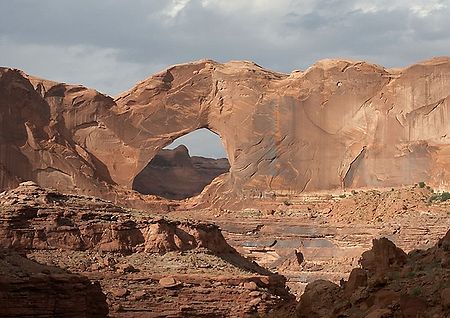
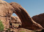
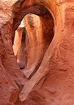
| Willow Gulch | Broken Bow Arch | Sandstone Dome | Deer Creek | Devil's Garden Hoodoos | ||||
 |
 |
 |
 |
 |
||||
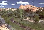
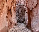
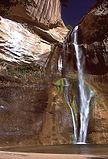
| Peek-a-Boo Gulch | Sooner Rocks | Dry Fork Narrows | Pine Creek | Calf Creek Falls Calf Creek Falls Calf Creek Falls is a perennial waterfall in the Grand Staircase-Escalante National Monument in Utah that totals . The lower tier is a cascade and is very popular, because it can be reached by an easy hike on a 5½ mile roundtrip trail. The upper tier is a plunge and is much less known, as it... |
||||
Sources and Further Reading
- Hiking the Escalante, by Rudi Lambrechtse (1985), ISBN 0-915272-27-X
- Canyon Hiking Guide to the Colorado Plateau, by Michael R. Kelsey (1995), ISBN 0-944510-11-6
- Canyons of the Escalante, Trails Illustrated Map (1994), ISBN 0-925873-98-5