
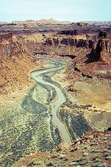
Dirty Devil River
Encyclopedia
Tributary
A tributary or affluent is a stream or river that flows into a main stem river or a lake. A tributary does not flow directly into a sea or ocean...
of the Colorado River
Colorado River
The Colorado River , is a river in the Southwestern United States and northwestern Mexico, approximately long, draining a part of the arid regions on the western slope of the Rocky Mountains. The watershed of the Colorado River covers in parts of seven U.S. states and two Mexican states...
, located in the U.S. state
U.S. state
A U.S. state is any one of the 50 federated states of the United States of America that share sovereignty with the federal government. Because of this shared sovereignty, an American is a citizen both of the federal entity and of his or her state of domicile. Four states use the official title of...
of Utah
Utah
Utah is a state in the Western United States. It was the 45th state to join the Union, on January 4, 1896. Approximately 80% of Utah's 2,763,885 people live along the Wasatch Front, centering on Salt Lake City. This leaves vast expanses of the state nearly uninhabited, making the population the...
. It flows through southern Utah from the confluence of Fremont River
Fremont River (Utah)
The Fremont River in Utah flows from the Johnson Valley Reservoir, which is located on the Wasatch Plateau near Fish Lake, southwest through Capitol Reef National Park to the Muddy Creek near Hanksville where the two rivers combine to form the Dirty Devil River, a tributary of the Colorado River...
and Muddy Creek
Muddy Creek (Utah)
Muddy Creek is a stream which drains portions of Emery and Wayne Counties in central Utah, in the western United States. It begins on the eastern slopes of the Wasatch Plateau at elevations above 10,500 feet . It turns southward near the town of Emery, then southeastward where it crosses under...
to the Colorado River
Colorado River
The Colorado River , is a river in the Southwestern United States and northwestern Mexico, approximately long, draining a part of the arid regions on the western slope of the Rocky Mountains. The watershed of the Colorado River covers in parts of seven U.S. states and two Mexican states...
.
Course
The Dirty Devil River is formed in Wayne CountyWayne County, Utah
Wayne County is a county located in the U.S. state of Utah. It was formed from Piute County in 1892. The county gets its name from a man who served as delegate to the constitutional convention, in honor of his son who was dragged to death by a horse. As of 2000 the population was 2,509, and by...
near Hanksville
Hanksville, Utah
Hanksville is a small town in Wayne County, Utah, United States, at the junction of State Routes 24 and 95. The town is just south of the confluence of the Fremont River and Muddy Creek, which together form the Dirty Devil River, which then flows southeast to the Colorado River...
at the confluence of the Fremont River
Fremont River (Utah)
The Fremont River in Utah flows from the Johnson Valley Reservoir, which is located on the Wasatch Plateau near Fish Lake, southwest through Capitol Reef National Park to the Muddy Creek near Hanksville where the two rivers combine to form the Dirty Devil River, a tributary of the Colorado River...
and Muddy Creek
Muddy Creek (Utah)
Muddy Creek is a stream which drains portions of Emery and Wayne Counties in central Utah, in the western United States. It begins on the eastern slopes of the Wasatch Plateau at elevations above 10,500 feet . It turns southward near the town of Emery, then southeastward where it crosses under...
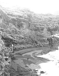
. It flows generally south through a 2000 feet (609.6 m) deep canyon in Wayne and Garfield
Garfield County, Utah
Garfield County is a county located in the U.S. state of Utah. As of 2000 the population was 4,735. It was named for James A. Garfield, President of the United States in 1881. Its county seat and largest city is Panguitch.-Geography:...
counties. Its lower 20 miles (32.2 km) flows through Glen Canyon National Recreation Area
Glen Canyon National Recreation Area
Glen Canyon National Recreation Area is a recreation and conservation unit of the National Park Service that encompasses the area around Lake Powell and lower Cataract Canyon in Utah and Arizona, covering 1,254,429 acres of mostly desert...
. It disembogues into Lake Powell
Lake Powell
Lake Powell is a huge reservoir on the Colorado River, straddling the border between Utah and Arizona . It is the second largest man-made reservoir in the United States behind Lake Mead, storing of water when full...
on the Colorado.
The canyon of the river is particularly isolated and is seldom visited compared to other natural areas in the region.
History
The Dirty Devil River was named during the 1869 Colorado River expeditionPowell Geographic Expedition of 1869
The Powell Geographic Expedition was a groundbreaking 19th century U.S. exploratory expedition of the American West, led by John Wesley Powell in 1869, that provided the first-ever thorough investigation of the Green and Colorado rivers, including the first known passage through the Grand Canyon...
led by John Wesley Powell
John Wesley Powell
John Wesley Powell was a U.S. soldier, geologist, explorer of the American West, and director of major scientific and cultural institutions...
.
The outlaw Butch Cassidy
Butch Cassidy
Robert LeRoy Parker , better known as Butch Cassidy, was a notorious American train robber, bank robber, and leader of the Wild Bunch Gang in the American Old West...
used tributary canyons of the Dirty Devil as a hideout
Robbers Roost
The Robbers Roost was an outlaw hideout in southeastern Utah used mostly by Butch Cassidy and his Wild Bunch gang in the closing years of the Old West....
in the 1890s.
Geology
The Dirty Devil River and its tributaries contribute approximately 150,000 tons of salt to the Colorado River, with the Muddy Creek tributary contributing an annual average of 86,000 tons by itself. The Fremont River tributary does not contribute significant amounts of salt. The Bureau of Reclamation has created a plan to reduce the salinity of the Dirty Devil River by collecting salty spring water and using deep-well injection to dispose of it. The plan, completed in 1987, has not been implemented due to its marginal cost effectiveness.Bridges
The river is spanned by a steel arch bridge on State Route 95State Route 95 (Utah)
State Route 95 or Bicentennial Highway is a state highway located in west-central San Juan, eastern Garfield, and central Wayne counties, in the southeast of the U.S. state of Utah. The highway received the name as its dedication coincided with the U.S. Bicentennial in 1976...
near milepost 45 in Garfield County
Garfield County, Utah
Garfield County is a county located in the U.S. state of Utah. As of 2000 the population was 4,735. It was named for James A. Garfield, President of the United States in 1881. Its county seat and largest city is Panguitch.-Geography:...
.