

Kaiparowits Plateau
Encyclopedia
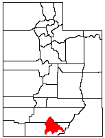
Utah
Utah is a state in the Western United States. It was the 45th state to join the Union, on January 4, 1896. Approximately 80% of Utah's 2,763,885 people live along the Wasatch Front, centering on Salt Lake City. This leaves vast expanses of the state nearly uninhabited, making the population the...
, in the southwestern United States
United States
The United States of America is a federal constitutional republic comprising fifty states and a federal district...
. Along with the Grand Staircase
Grand Staircase
For the similarly named structure on the RMS Titanic, see Grand Staircase of the TitanicFor the stairs in the White House see Grand Staircase ...
and the Canyons of the Escalante
Canyons of the Escalante
The Canyons of the Escalante is a collective name for the erosional landforms created by the Escalante River and its tributaries, the Escalante River Basin. Located in southern Utah in the western United States, these sandstone features include high vertical canyon walls, water pockets, narrow...
, it makes up a significant portion of the Grand Staircase-Escalante National Monument
Grand Staircase-Escalante National Monument
The Grand Staircase-Escalante National Monument contains 1.9 million acres of land in southern Utah, the United States. There are three main regions: the Grand Staircase, the Kaiparowits Plateau, and the Canyons of the Escalante. President Bill Clinton designated the area as a U.S. National...
. Its extension to the southeast, Fiftymile Mountain, runs nearly to the Colorado River
Colorado River
The Colorado River , is a river in the Southwestern United States and northwestern Mexico, approximately long, draining a part of the arid regions on the western slope of the Rocky Mountains. The watershed of the Colorado River covers in parts of seven U.S. states and two Mexican states...
and Lake Powell
Lake Powell
Lake Powell is a huge reservoir on the Colorado River, straddling the border between Utah and Arizona . It is the second largest man-made reservoir in the United States behind Lake Mead, storing of water when full...
, and is a prominent part of the northern skyline from the Glen Canyon National Recreation Area
Glen Canyon National Recreation Area
Glen Canyon National Recreation Area is a recreation and conservation unit of the National Park Service that encompasses the area around Lake Powell and lower Cataract Canyon in Utah and Arizona, covering 1,254,429 acres of mostly desert...
.
Geography
Escalante, Utah
Escalante is a city in Garfield County, Utah, United States, along Utah Scenic Byway 12. As of the 2000 census, the city population was 818.The town was named after Silvestre Vélez de Escalante, a Franciscan missionary and the first European explorer in the region...
in Garfield County
Garfield County, Utah
Garfield County is a county located in the U.S. state of Utah. As of 2000 the population was 4,735. It was named for James A. Garfield, President of the United States in 1881. Its county seat and largest city is Panguitch.-Geography:...
, to the south and southwest through Kane County
Kane County, Utah
As of the census of 2000, there were 6,046 people, 2,237 households, and 1,628 families residing in the county. The population density was 2 people per square mile . There were 3,767 housing units at an average density of 1 per square mile...
and nearly to the border with Arizona
Arizona
Arizona ; is a state located in the southwestern region of the United States. It is also part of the western United States and the mountain west. The capital and largest city is Phoenix...
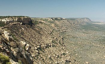
. At its southeastern end the plateau rises from Lake Powell nearly 4000 feet (1200 m) to an elevation of 7584 feet (2311 m). The northeastern edge of the plateau is defined by the Straight Cliffs, below which are the broad sandstone flats of the Escalante River
Escalante River
right|Location of the Escalante River within UtahThe Escalante River is a tributary of the Colorado River. It is formed by the confluence of North and Birch Creeks near the town of Escalante in south-central Utah, and from there flows southeast for approximately before joining Lake Powell...
. The western edge of the plateau is at the Paria River
Paria River
The Paria River is a tributary of the Colorado River, approximately long, in southern Utah and northern Arizona in the United States. It drains a rugged and arid region northwest of the Colorado, flowing through roadless slot canyons along part of its course....
, Cottonwood Canyon
Cottonwood Canyon (Utah)
Cottonwood Canyon in the U.S. state of Utah is a water-carved canyon that has eroded along weak locations in the Earth's crust at the joins between major geological regions...
, and the Cockscomb.
The southern end of the plateau is deeply dissected by tributaries of the Colorado River, including Rock, Last Chance, Warm, Wahweap, and Coyote Creeks. These canyons are now major side channels of Lake Powell. An extension of the plateau's high terrain is known as Smoky Mountain, location of one of the few roads on the plateau. The northwestern end of the plateau is less well defined, essentially merging with the Aquarius Plateau
Aquarius Plateau
The Aquarius Plateau is a physiographic region within Garfield and Wayne counties in south-central Utah. The plateau, an uplift on the much larger Colorado Plateau, is the highest in North America...
. Canaan Peak, just south of Highway 12 and the town of Escalante, rises to 9233 feet (2814 m). Overall, the plateau covers an area of approximately 1650 square miles (4225 km²), much of it covered by pinyon
Single-leaf Pinyon
The Single-leaf Pinyon, ', is a pine in the pinyon pine group, native to the United States and northwest Mexico. The range is in southernmost Idaho, western Utah, Arizona, southwest New Mexico, Nevada, eastern and southern California and northern Baja California.It occurs at moderate altitudes from...
-juniper woodland.
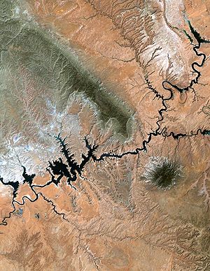
Navajo Mountain
Navajo Mountain is a peak in San Juan County, Utah, with its southern flank extending into Coconino County, Arizona. It holds an important place in the traditions of three local Native American tribes.-Geologic history:...
. The Kaiparowits Plateau is the darker area to the left, while the Escalante River Basin is the lighter area to the right. The Colorado River (as Lake Powell) runs across the bottom of the image, and at the upper right is the Aquarius Plateau and Boulder Mountain
Boulder Mountain (Utah)
Boulder Mountain in Utah, USA makes up half of the Aquarius Plateau of South Central Utah in Wayne and Garfield counties. The mountain rises to the west of Capitol Reef National Park and consists of steep slopes and cliffs with over 50,000 acres of rolling forest and meadowlands on the top...
.
Geology
During the later part of the CretaceousCretaceous
The Cretaceous , derived from the Latin "creta" , usually abbreviated K for its German translation Kreide , is a geologic period and system from circa to million years ago. In the geologic timescale, the Cretaceous follows the Jurassic period and is followed by the Paleogene period of the...
geologic period, the area that is now the Kaiparowits Plateau was located near the western shore of the Western Interior Seaway
Western Interior Seaway
The Western Interior Seaway, also called the Cretaceous Seaway, the Niobraran Sea, and the North American Inland Sea, was a huge inland sea that split the continent of North America into two halves, Laramidia and Appalachia, during most of the mid- and late-Cretaceous Period...
. The interior of the plateau was an area of peat
Peat
Peat is an accumulation of partially decayed vegetation matter or histosol. Peat forms in wetland bogs, moors, muskegs, pocosins, mires, and peat swamp forests. Peat is harvested as an important source of fuel in certain parts of the world...
swamps, while what is now the Straight Cliffs were at the shoreline. Further to the west was an area known as the Sevier Highlands. Erosion from the Highlands deposited approximately 1500 feet (500 m) of what is now known as the Straight Cliffs Formation, a layer of sandstone that makes up the base of the plateau. Remnants of the peat are now seen as beds of coal within this layer. Later deposits during the Cretaceous period formed higher sandstone layers, known as the Wahweap
Wahweap Formation
The Wahweap Formation of the Grand Staircase-Escelante National Monument is a geological formation in southern Utah and northern Arizona, around the Lake Powell region, whose strata date back to the Late Cretaceous...
and Kaiparowits
Kaiparowits Formation
The Kaiparowits Formation is a sedimentary rock formation found in the Kaiparowits Plateau in Grand Staircase-Escalante National Monument, in the southern part of Utah in the western United States. It is over 2800 feet thick, and is Campanian in age...
Formations. Further deposition during later epochs formed layers that are now seen at the surface of the plateau, including the limestone layers of the Wasatch Formation.
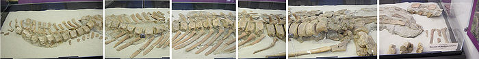
Fossils
The sandstone layers of the Kaiparowits Plateau have become a unique source of fossilized remains of the Late Cretaceous Period, vital to understanding the evolution of dinosaur and early mammalian species. These layers represent not only an unbroken sequence of the period between 70 and 82 million years ago, but have also preserved fine details of the bones, teeth, egg shells, and even the tracks of the animals that lived then. The skull of a ceratopsid, a horned dinosaur, was unearthed from the Wahweap Formation in 1998. A species of StruthiomimusStruthiomimus
Struthiomimus is a genus of ornithomimid dinosaur from the late Cretaceous of Alberta, Canada. It was a long-legged, ostrich-like dinosaur.The bipedal Struthiomimus stood about long and tall at the hips and weighed around...
, a toothless (yet carnivorous) dinosaur, was identified in the Kaiparowits Formation. As recently as 2007, the characterization of an unusual species of Gryposaurus
Gryposaurus
Gryposaurus was a genus of duckbilled dinosaur that lived about 83 to 75.5 million years ago, in the Late Cretaceous of North America...
, a duck-billed dinosaur, was announced.
Controversy
In 1965, the Southern California EdisonSouthern California Edison
Southern California Edison , the largest subsidiary of Edison International , is the primary electricity supply company for much of Southern California, USA. It provides 14 million people with electricity...
Company proposed the construction of a 3000 megawatt coal-fired generation plant within the Kaiparowits Plateau.
This plant was intended to be fed by large coal deposits in the plateau, which may have yielded up to 4 billion tons of fuel. The electricity produced would have gone to the growing populations near Los Angeles
Los Angeles, California
Los Angeles , with a population at the 2010 United States Census of 3,792,621, is the most populous city in California, USA and the second most populous in the United States, after New York City. It has an area of , and is located in Southern California...
, San Diego
San Diego, California
San Diego is the eighth-largest city in the United States and second-largest city in California. The city is located on the coast of the Pacific Ocean in Southern California, immediately adjacent to the Mexican border. The birthplace of California, San Diego is known for its mild year-round...
, and Phoenix
Phoenix, Arizona
Phoenix is the capital, and largest city, of the U.S. state of Arizona, as well as the sixth most populated city in the United States. Phoenix is home to 1,445,632 people according to the official 2010 U.S. Census Bureau data...
. Initially hailed as an economic boon to this isolated area of southern Utah, the proposal met with growing opposition from federal regulatory agencies and from environments groups
Sierra Club
The Sierra Club is the oldest, largest, and most influential grassroots environmental organization in the United States. It was founded on May 28, 1892, in San Francisco, California, by the conservationist and preservationist John Muir, who became its first president...
, who had only recently experienced the scenic canyons of the Colorado River and its tributaries being inundated by Lake Powell, behind the Glen Canyon Dam
Glen Canyon Dam
Glen Canyon Dam is a concrete arch dam on the Colorado River in northern Arizona in the United States, just north of Page. The dam was built to provide hydroelectricity and flow regulation from the upper Colorado River Basin to the lower. Its reservoir is called Lake Powell, and is the second...
. After ten years of dispute and facing rising construction costs, the proposal was abandoned in 1975.